

National Character Area 140
Yeovil Scarplands - Analysis: Ecosystem Services
Analysis supporting Statements of Environmental Opportunity
The following analysis section focuses on a selection of the key provisioning, regulating and cultural ecosystem goods and services for this NCA. These are underpinned by supporting services such as photosynthesis, nutrient cycling, soil formation and evapo-transpiration. Supporting services perform an essential role in ensuring the availability of all ecosystem services.
Bodiversity and geodiversity are crucial in supporting the full range of ecosystem services provided by this landscape. Wildlife and geologically-rich landscapes are also of cultural value and are included in this section of the analysis. This analysis shows the projected impact of Statements of Environmental Opportunity on the value of nominated ecosystem services within this landscape.
Further analysis on landscape attributes and opportunities for this NCA is contained in the Analysis: Landscape Attributes & Opportunities section.
Natural Capital
Further information on Natural Capital within this NCA is contained in the Natural Capital and Key Ecosystem Services section.
The Yeovil Scarplands NCA provides a wide range of benefits to society. Each is derived from the attributes and processes (both natural and cultural features) within the area. These benefits are realised through the ‘ecosystem services’ that flow from the ‘ecosystem assets’ or ‘natural capital’ of a place.
Natural capital means ‘the elements of nature that directly or indirectly produce value to people, including ecosystems, species, freshwater, land, minerals, the air and oceans, as well as natural processes and functions’ (Natural Capital Committee, 2017).
Ecosystem Services Main Beneficiaries
The below map displays the main beneficiaries of each ecosystem service identified within this NCA and neighbouring NCAs. These range from being of international importance to local importance. Some services have not been assessed within all NCAs, and therefore in some NCAs are displayed as “N/A” (not applicable).
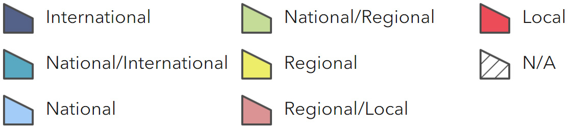
Main Beneficiaries Map
View Main Beneficiaries Map full screen in a new tab View Interactive Map HelpEcosystem service analysis
The following sections show the analysis used to determine key Ecosystem Service opportunities within the area. These opportunities have been combined with the analysis of landscape opportunities to create Statements of Environmental Opportunity. Please note that the following analysis is based upon available data and current understanding of ecosystem services. It does not represent a comprehensive local assessment. Quality and quantity of data for each service is variable locally and many of the services listed are not yet fully researched or understood. Therefore analysis and opportunities may change upon publication of further evidence and better understanding of the inter-relationship between services at a local level.
Note that numbers and figures in the body of the text are based on the 2014 profiles, unless otherwise stated.
Provisioning Services
Food provision
Assets/attributes: main contributors to service –
- Good arable soils in south-west part of the area
- Dairy products
- Beef, Lamb, Pigs, Poultry
State – Sixty-seven percent of the NCA’s agricultural area is under grass or uncropped land. This supports just over half the farms engaged in livestock production.
Arable production is found across the NCA, often in mixed systems, but where the light, fertile Yeovil Sands occur, arable, horticulture and fruit growing predominate.
Maize is grown as a fodder crop.
Soils are generally good with Grade 2 accounting for 12 percent and Grade 3 71 percent.
Main beneficiary – Regional
Analysis – Relative stability for a long period has seen the landscape adapted to pastoral, principally dairy, systems but with important numbers of mixed farms, and in the south-west part of NCA more arable.
More recent trends in the dairy industry have brought a reduction in the number of holdings (down 31 percent 2000-2009) but a possible intensification that has maintained production. Some of the dairy herds appear to have been replaced with grazing livestock (up 10 percent).
Specialist pig and poultry rearing is important in the area, up 11 and 49 percent respectively (2000-2009).
A decline in mixed farming of 39 percent from 2000-2009 is notable.
Intensive arable on the Yeovil Sands gives good harvests but is resulting in high levels of soil erosion and consequent siltation of rivers. Similarly, increased growing of fodder maize may be increasing soil compaction and vulnerability to erosion.
Root vegetables and fruit growing also declined sharply over the period 2000- 2009.
Opportunities – Work with farmers and land managers to maintain a balance between profitability and the long-term viability of food production levels, and the protection and enhancement of the natural and historic environment and sense of place.
Provide livestock farmers with encouragement and advice on integrating extensive beef production and sheep grazing with management of the semi- natural grasslands within the NCA.
Work with the farming community to ensure good soil and nutrient management, thereby securing a sustainable future for farming, protecting environmental features within the area, and supporting the supply of other ecosystem services.
Encourage management of remaining traditional orchards and sympathetic management of new orchards to maximise their benefits for biodiversity and their contribution to sense of place and culture.
Develop links between local food producers and local tourism, hotels, pubs, schools and others. Highlight links between the way in which food has been and is produced and the valued landscape it produces.
Principal services offered by opportunities –
- Food provision
- Regulating soil quality
- Regulating soil erosion
- Climate regulation
- Regulating water quality
- Sense of place/inspiration
- Sense of history
- Biodiversity
Timber provision
Assets/attributes: main contributors to service –
- Broadleaved woodland
- Well-timbered hedgerows
- Conifer plantation
State – Approximately 805 ha of conifer woodland with 628 ha of this Plantation on Ancient Woodland Sites (PAWS).
More than 3,000 ha of broadleaved woodland, much of this in small farm woods and 623 ha of Ancient Semi-natural Woodland.
Main beneficiary – Local
Analysis – It is unclear if the timber provision from this NCA is of any more than local importance.
Much of the broadleaved woodland is on steeper scarp slopes and within the deep goyles and therefore extraction would be uneconomic.
Much of the coniferous woodland is planted on Ancient Woodland Sites and, under current forestry policy, would be suitable and targeted for restoration to broadleaved woodland.
It is likely that some of the parkland and estate woodland could provide suitable trees for bespoke works.
Opportunities – When current crops are harvested from PAWS careful consideration needs to be given to restoring sites to broadleaved trees.
As with the loss of English elm in the 1970s, ash die-back may have an impact on current timber opportunities and future timber planting decisions.
Expansion of broadleaved woodland identified by the Forestry Commission for this area may provide enough ‘critical mass’ to promote a small-scale timber industry.
Principal services offered by opportunities –
- Timber provision
- Sense of place/inspiration
- Regulating water flow
- Regulating soil erosion
- Biodiversity
Water availability
Assets/attributes: main contributors to service –
- Rivers Brue, Yeo, Cary, Parrett, Isle and Axe
- Chard and Sutton Bingham reservoirs
State – The main rivers are the rivers Yeo, Brue and Parrett which drain into the Somerset Levels and Moors.
Sutton Bingham Reservoir is the public water supply for Yeovil, while the Chard Reservoir is a Local Nature Reserve, not supplying drinking water (Chard Reservoir was built to feed the Chard canal in 1842, not as a public water supply).
Groundwater resources are mainly from the limestones outside of the NCA.
According to the Catchment Abstraction Management Plan (Parrett, Brue and West Somerset Streams CAMS (Catchment Abstraction Management Plan), Environment Agency, December 2012) surface water is available for abstraction in the north of the NCA but is ‘not available’ in the centre and west of the NCA and is ‘over abstracted’ in the south around Sutton Bingham Reservoir. Groundwater generally has a ‘no water available’ status within the NCA and abstraction is ‘over licensed’ in the west.
Main beneficiary – Regional
Analysis – Water is abstracted throughout the whole NCA but while the NCA includes scarps of limestone (the Brue rises from these) and sand, interspersed with clay vales, the fragmented nature of the strata means that groundwater comes from aquifers outside the NCA.
Additional abstraction takes place from wells and boreholes in the Yeovil Sands, but yield and licensed volumes tend to be lower than in the more productive limestones.
Water is abstracted for fish farms and hydropower generation and then returned back to the watercourse downstream.
A much smaller quantity is abstracted for industrial and commercial use, agriculture, amenity and private water supply.
The Somerset Levels and Moors (SPA/Ramsar site) is downstream of the NCA. The impact of any water shortage in the NCA area could be felt in all or part of this internationally important site.
Opportunities – With Yeovil’s continued expansion and subsequent demand for water in an over abstracted area, every effort should be made to include water-saving and water-harvesting features in new and where possible existing housing.
Small-scale winter water capture and storage schemes could aid those areas where abstraction for agriculture and private water supply is now limited or denied.
These may also, in a small way, help alleviate high winter river flows and downstream flooding.
Principal services offered by opportunities –
- Water availability
- Food provision
- Biodiversity
Genetic diversity
Assets/attributes: main contributors to service –
- Relict commercial and farm orchards
State – Many scattered and neglected orchards are found across the NCA; survivors from a period when cider production was an important element of the local economy.
Main beneficiary – Local
Analysis – As well as being an important cultural legacy for the area, these orchards may contain useful genetic material in the form of old varieties of cider apple which can be used in modern cross-breeding to produce new strains.
Opportunities – Raise local awareness of orchards and apple varieties. Link owners of orchards with local fruit and cider producers and suppliers.
Encourage regeneration of existing orchards and new planting with local varieties.
Principal services offered by opportunities –
- Genetic diversity
- Biodiversity
- Sense of history
- Pollination
Biomass energy
Assets/attributes: main contributors to service –
- Broadleaved and coniferous woodland
- Hedgerow and streamside trees
State – Yield maps show that the majority of the NCA has the potential for a high yield of short rotation coppice, and a medium yield for miscanthus.
Main beneficiary – Local
Analysis – The total woodland cover of 6 percent offers limited opportunities for the production of biomass as a by- product of commercial forestry production and by bringing unmanaged woodlands back under management.
Short rotation coppice could be introduced without damaging character if carefully planned and located. Miscanthus can have a greater impact if thoughtlessly placed and can lead to soil compaction and erosion issues due to life and harvesting cycle.
For information on the potential landscape impacts of biomass plantings within the NCA, refer to the tables on the Natural England website.
Opportunities – Careful consideration will have to be given to the potential negative impacts of large-scale biomass production in this NCA.
If highly mechanised, short rotation coppice and miscanthus production can have adverse impacts on soil structure and levels of erosion that could exacerbate siltation.
Principal services offered by opportunities –
- Biomass energy
Regulating Services
Climate regulation
Assets/attributes: main contributors to service –
- Soils
- Grasslands
- Woodlands
State – Carbon storage in the soils is low throughout the NCA, ranging from 0 to 5 percent with occasional areas reaching 10 percent.
The soils underlying woodlands and permanent pasture are likely to be of higher carbon content.
The regularly tilled arable soils of the Yeovil Sands are likely to have very low carbon/organic content.
Main beneficiary – Local
Analysis – This NCA has a relatively low carbon storage potential as soils tend to be loamy clayey which do not have high carbon storage capacity.
However those underlying woodland and permanent grassland may have increased capacity and an ongoing sequestration role, especially if organic matter content is increased.
Some of the regularly tilled soils are principally mineral soils and have little or no organic material within them.
Woodlands, hedgerows and hedgerow trees will be good at capturing and storing carbon.
Opportunities – Carbon sequestration in the majority of the area’s soils can be increased by increasing organic matter inputs and/or by reducing the frequency/area of cultivation.
Increasing the area of woodlands (currently 6 percent) will also benefit climate regulation through ongoing sequestration of carbon.
Creation of wetland areas where peaty soils can form would also store carbon.
Principal services offered by opportunities –
- Climate regulation
- Biodiversity
- Biomass energy
- Timber provision
Regulating coastal erosion and flooding
No information available.
Regulating water quality
Assets/attributes: main contributors to service –
- Semi-natural habitats
- Grasslands Rivers
- Sutton Bingham Reservoir
State – For information regarding the current state of water quality within this NCA, refer to the Environment Agency (Draft river basin management plan maps).
Main beneficiary – Regional
Analysis – It is likely that shifts from traditional pastoral management to pig rearing and increasing areas of arable production in this NCA are creating conditions for increased erosion of farmland.
Increased cultivation on steeper slopes, crops that leave bare ground during periods of high rainfall and a reduction in the extent of pasture all contribute to erosion and sediment transport into watercourses.
Similarly, poor stock management, slurry management and fertiliser application can and have led to elevated levels of nitrate and phosphate in the area’s rivers.
Opportunities – Work with landowners to implement best practice approaches in water quality management including grazing regimes, stocking rates, applications of organic matter and fertilizer, maintenance of farm infrastructure, and cultivation and cropping activity.
Work with farmers and landowners to identify mechanisms for the lowering of application rates of fertiliser and pesticide.
Promote the use of contour ploughing and buffer strips to watercourses, the creation of woodlands and hedgerows and the creation of riparian semi-natural habitats.
Buffer strip creation will help reduce surface flows and will capture sediments.
Promote improvements in farm infrastructure and waste management.
Encourage positive management of vegetation along watercourses that maintains water flow, but helps trap sediments and nutrients.
Principal services offered by opportunities –
- Regulating water quality
- Regulating soil erosion
- Water availability
- Biodiversity
Regulating water flow
Assets/attributes: main contributors to service –
- Rivers
- Semi-natural habitats
State – Most of the NCA is either at little or no risk of flooding, with the area characterised by relatively small and steep watercourses that keep flooding to a minimum. There are pockets of higher risk, particularly in the north-west and central parts of the NCA, along the River Yeo, on various small streams with associated surface water and sewer flooding.
Yeovil is situated on a relatively high plateau, well above the flood plain of the adjacent River Yeo, but some communities, namely Crewkerne, Martock, South Petherton and Ilminster do have localised problems from the Upper Isle and the Upper Parrett and their tributaries, exacerbated (particularly in Crewkerne) by small culverted watercourses which are prone to blockage or are undersized.
In South Petherton flooding has been exacerbated by farming practices which have increased field run-off locally, contributing to localised flooding well outside of the fluvial flood plain area.
Main beneficiary – Regional
Analysis – The upper reaches of rivers are often affected by isolated flooding as a consequence of complex interactions of fluvial and surface water.
Yeovil, above the flood plain of the Yeo, is only minimally at risk.
While local solutions to small-scale flooding experienced within the NCA can be achieved through the actions identified within the River Parrett, and the North and Mid Somerset Catchment Flood Management Plans, these also need to be developed with a mind to reduce peak flows leaving this NCA and entering the Somerset Levels and Moors.
The nature of these rivers’ upper reaches and networks of tributaries means that effective placing of small but widespread measures could be the best approach.
Particular attention should be paid to land use patterns that aggravate both the mobilisation of sediment and the cross- surface flows of water at periods of highest flood risk (generally the winter).
Opportunities – Measures identified in the River Parrett, and the North and Mid Somerset Catchment Flood Management Plans (Parrett Catchment Flood Management Plan, Environment Agency, June 2012) should be implemented.
Work with the farming community to encourage best practice farming and soil management, paying particular attention to water/run-off management at a farm- scale and improvements in water quality.
Investigate mechanisms to slow water flows in strategic locations to both protect local communities and to slow the rate at which water enters the neighbouring Somerset Levels and Moors.
Principal services offered by opportunities –
- Regulating water flow
- Regulating water quality
- Biodiversity
- Sense of place/ inspiration
- Regulating soil erosion
- Biodiversity
Regulating soil quality
Assets/attributes: main contributors to service –
- Soil types
- Geomorphological processes
- Geodiversity
- Semi-natural habitats
- Groundwater levels
State – There are seven main soilscape types in this NCA:
- Slightly acid loamy and clayey soils with impeded drainage (26 percent).
- Lime-rich loamy and clayey soils with impeded drainage (23 percent).
- Freely draining slightly acid loamy soils (17 percent).
- Slowly permeable seasonally wet slightly acid but base-rich loamy and clayey soils (14 percent).
- Shallow lime-rich soils over limestone (13 percent).
- Freely draining lime-rich loamy soils (3 percent).
- Loamy and clayey flood plain soils with naturally high groundwater (3 percent).
Main beneficiary – Regional
Analysis – The slightly acid and lime-rich loamy and clayey soils with impeded drainage (26 and 23 percent respectively) are easily poached by livestock and compacted by machinery when the soil is wet. Weak topsoil structures can be easily damaged, with careful timing of activities required to reduce the likelihood of soil compaction.
Careful management of weak topsoil will help to maintain a good soil structure, with minimum tillage, such as direct drilling, working well on these soils.
The shallow lime-rich soils over limestone (13 percent) are typically shallow and droughty but due to their calcareous nature have a degree of natural resilience. These and the freely draining slightly acid loamy soils (17 percent) may, to a limited extent, be valuable for aquifer recharge, requiring the maintenance of good structural conditions to aid water infiltration and requiring the matching of nutrients to needs to prevent pollution of the underlying aquifer.
The slowly permeable seasonally wet slightly acid but base-rich loamy and clayey soils (14 percent) may suffer compaction and/or capping as they are easily damaged when wet. In turn this may lead to increasingly poor water infiltration and diffuse pollution as a result of surface water run-off.
All of the above soils have some potential for increased organic matter levels through management interventions.
Opportunities – Work with the farming community to encourage best practice management of their soils: to increase organic matter, judge best times to carry out operations, avoid compaction and poaching, and apply only required levels of fertiliser to the soil.
Promote the use of green manure crops and nitrogen fixing legumes to both enhance soil structure and fertility and maintain an erosion-resistant vegetation cover throughout the year.
Principal services offered by opportunities –
- Regulating soil quality
- Regulating water quality
- Regulating water flow
- Biodiversity
- Food provision
Regulating soil erosion
Assets/attributes: main contributors to service –
- Soil types
- Groundwater levels
- Soil management
- Semi-natural habitats
State – The majority of soils covering the NCA (82 percent) are at risk of erosion.
The Upper Parrett (whose upper tributaries rise within this NCA) and the Upper Brue have problems with sedimentation arising from soil erosion associated with surface water run-off in areas of intensive dairy, pig, poultry and maize production, especially on more vulnerable soils and on steep slopes (DEFRA catchment priorities identified under the England Catchment Sensitive Farming Project).
Main beneficiary – Regional
Analysis – The loamy and clayey soils are at risk from both capping and slaking in dry weather, and compaction, from either livestock or vehicle use, when soils are too wet.
Both increase the risk of soil erosion when water runs across the soil instead of percolating through it. This is especially so on steeper slopes and on intensively managed arable land where organic content binding the soil particles is at low density.
Careful management of vegetation cover and timing of operations is essential.
The freely draining slightly loamy soils have enhanced risk of erosion on moderately or steeply sloping land where cultivated or bare soil is exposed, often exacerbated where organic matter levels are low after continuous arable cultivation or where soils are compacted.
Opportunities – Ensure that agricultural operations are situated in locations where increased soil erosion is not a likely outcome.
Introduce measures to slow cross-field water flows, such as grass strips and beetle banks.
Maintain vegetation cover using the likes of winter stubbles and green manures.
Principal services offered by opportunities –
- Regulating soil erosion
- Regulating soil quality
- Regulating water quality
- Regulating water flow
- Water availability
Pollination
Assets/attributes: main contributors to service –
- Semi-natural habitats
- Orchards
- Arable crops
State – There are 650 ha of calcareous grassland and lowland meadows, a small number of relict orchards and an extensive network of hedgerows all potentially supporting populations of pollinating fauna.
Main beneficiary – Local
Analysis – Pollination services are patchily distributed around the NCA. Semi-natural habitats do provide islands of pollinator-friendly species, but as a network this is probably quite weak.
Pollination services for agriculture are probably in most demand in the arable areas around South Petherton; unfortunately it is in this area that semi- natural habitats (including hedgerows so characteristic of the rest of the NCA) are most poorly represented.
Opportunities – Manage the existing semi-natural grassland resource to maintain or restore its floristic diversity.
Identify areas where pollinator habitat is absent and introduce measures to restore and re-create floristically-rich habitats.
Create and manage flower-rich field margins to increase pollinator food sources.
Work with local communities and landowners to identify suitable locations for planting new orchards using local, traditional apple varieties.
Principal services offered by opportunities –
- Pollination
- Pest regulation
- Biodiversity
- Genetic diversity
- Food provision
Pest regulation
Assets/attributes: main contributors to service –
- Semi-natural habitats
State – There are 650 ha of calcareous grassland and lowland meadows, a small number of relict orchards and an extensive network of hedgerows.
Main beneficiary – Local
Analysis – As with pollination services above, the habitats and niches that are favoured by natural predators are patchily distributed across the NCA.
Opportunities – The same actions that benefit the pollinators above will have a beneficial effect upon species that provide important pest regulation services.
Principal services offered by opportunities –
- Pest regulation
- Pollination
- Biodiversity
- Genetic diversity
- Food provision
Cultural Services
Sense of place/inspiration
Assets/attributes: main contributors to service –
- Rolling scarp landform
- Hill forts
- Variety of limestone types used in local buildings
- Mansions, manors and parklands
- Long views over and out of the area
State – Sense of place is provided by the rolling landform of dramatic scarps and broken hills divided by broad valleys with slow moving, meandering rivers.
The area has a distinct rural character, with small irregular arable or pasture fields separated by species-rich hedgerows and numerous small woodlands.
Fragments of wet, marshy grassland in the flood plains and calcareous grasslands on the sculpted limestone scarps and hills are very characteristic.
This rural character is emphasised by hamlets and villages that are hidden from view at the foot-slopes of scarps or within small valleys, with older buildings built from the varied but unifying local stone.
Much of the higher ground has an open, almost downland-like character affording far-reaching views.
Abandoned quarries are distinctive in the landscape and provide access to important exposures of fossil- rich rocks and strata.
Strong literary association with T.S. Eliot, who is buried in the village church at East Coker.
Sense of inspiration and escapism are likely to be especially associated with the prominent hill forts at South Cadbury and Ham Hills, as well as the open ridgeline summits that afford far-reaching views over surrounding land.
The designed landscapes and gardens of Montacute, Barrington Court, Sherborne Park and numerous ‘gentry houses’.
Main beneficiary – Regional
Analysis – The physiographical features that provide a sense of place – scarp and vale landscape – are in good condition with character mostly intact. Villages and towns are still usually maintained within their vale settings, with only Yeovil starting to sprawl out and over its encircling scarps.
Farming patterns have changed somewhat with mixed farming showing a sharp decline. This may be having an impact on the scarp and vale landscape in terms of replacing the highly heterogeneous land use patterns with a more homogenised one. Similarly, the decline in dairy holdings may have knock-on effects in terms of land use and landscape character.
The characteristic building materials of the NCA are potentially available for repair and new build via a number of open quarries: Ham Hill stone will certainly remain available for many decades to come.
Most of the major historic houses and parklands are under positive management and contributing to the sense of place. However, many of the smaller houses and parks are in need of survey and some restorative actions.
Pressure for change is greatest around the southern half of the NCA, with Yeovil the main area of both economic and housing activity. However, towns like Crewkerne, Ilminster and, just outside the NCA, Wincanton are all expanding, creating an area of growth along the A303.
Tranquillity and sense of place are weakened or highly modified in these areas.
Opportunities – The ridge lines and hilltops that provide expansive views across the NCA should be maintained free of development.
Where appropriate farmers should be encouraged to maintain the mixed farming and land use systems that characterise large parts of the NCA.
Main opportunities lie with managing the growth of settlements along the A303. Ensuring use of green infrastructure principals and developments that work with the landform are employed.
Principal services offered by opportunities –
- Sense of place/inspiration
- Sense of history
- Tranquillity
- Biodiversity
- Recreation
- Geodiversity
Sense of history
Assets/attributes: main contributors to service –
- Prehistoric hill forts at South Cadbury and Ham Hill
- Roman remains at Ilchester and in the south
- Saxon burhs such as South Petherton, Crewkerne, and Bruton
- Moated sites and castles such as Castle Cary
- Field patterns reflect post- medieval enclosure of medieval strip fields
- 13 Registered Parks and Gardens covering 1,861 ha
- 74 Scheduled Monuments
- 4,317 Listed Buildings
State – Aspects of history likely to be most evident to the non-specialist include the prominent hill forts at South Cadbury and Ham Hill, the medieval castle remains such as at Castle Cary, the mansions and surrounding parklands such as Montacute, Barrington Court, Dillington House and Sherborne Park, and the older buildings of traditional local stone, most notably the distinctive Ham Hill stone.
Main beneficiary – Regional
Analysis – The current land uses, patterns of enclosure, location of towns, villages, historic houses and gardens all reflect and combine to give the NCA its sense of its history.
The assets are all generally in good condition and their ‘story’ is still legible. However, increasing urbanisation around some of the larger towns and changes in agricultural land use are eroding that sense and legibility. To some extent this is merely the continued ‘imprint’ of history being formed, but these changes can be made in ways that do not necessarily damage the existing assets.
Opportunities – Ensure that historic houses and gardens are in best possible management.
Avoid damage to buried archaeology and upstanding earthworks from agricultural activities.
Maintain the important suite of Listed Buildings and work to remove any that appear on the Heritage at Risk register.
Ensure that suitable quarries are able to provide stone for the various local built styles and traditions.
Ensure that land use patterns representing Medieval open field systems are not enclosed by new hedgerow or other boundary creation.
Maintain a sense of local vernacular in new buildings and the restoration of older buildings for new uses.
Principal services offered by opportunities –
- Sense of history
- Sense of place/inspiration
- Recreation
- Geodiversity
- Tranquillity
Tranquility
Assets/attributes: main contributors to service –
- Intimate rural landscapes
- Intricate network of rural highways and byways
- Long uninterrupted views from scarps over landscape
- Low levels of infrastructure away from larger towns
- Strong sense of local vernacular and historical continuity through large houses, churches and domestic buildings
State – The NCA is still tranquil and remote, away from the bustling A303 corridor.
The south of the NCA is less tranquil than the north, though areas such as those around Halstock and Corscombe in the Dorset part of the NCA are very tranquil.
Tranquillity has declined from 90 percent in the 1960s to around 50 percent in 2007.
Tranquillity ‘scores’ range between 36 and -66.
Main beneficiary – Local
Analysis – Tranquillity in this NCA is worth describing in terms of the contrast between the busy, built, expanding and noisy A303 corridor, which includes Yeovil, Sherborne, Crewkerne, Wincanton and Ilminster and the rural pastoral north around Bruton and the deeply remote- feeling area around Corscombe and Halstock.
Sensitive design of urban extensions, new roads and infrastructure and softening the edges of existing urban areas can all help to decrease the levels of intrusion.
Opportunities – Prevent increases over current levels of intrusion by keeping significant development within the currently intruded envelope.
Attempt to reduce negative impacts on tranquillity through measures to screen and soften hard urban edges, industrial and road infrastructure and reduce night-time light pollution.
Principal services offered by opportunities –
- Tranquillity
- Sense of place/inspiration
- Sense of history
- Biodiversity
Recreation
Assets/attributes: main contributors to service –
- 1,500-kilometre network of rights of way (at a density of 1.88 km/km2)
- MacMillan Way, Liberty Trail, Monarch’s Way, Celtic Way, Strawberry Line (National Cycle Network route 26)
- Ham Hill Country Park and Yeovil Country Park
- 663 ha of publicly accessible land (covering just 1 percent of the NCA).
- Sutton Bingham and Chard reservoirs
State – Yeovil Country Park is a 51 hectare urban fringe countryside site that wraps itself around the southern and eastern side of the town, is well used and holds a Green Flag award.
The 164 hectare Ham Hill Country Park has a wider catchment and also holds a Green Flag award.
Main beneficiary – Local
Analysis – Recreation is not a particular priority for this NCA. It has very little in terms of nationally recognised infrastructure, though National Cycle Route 26 runs from Portishead on the North Somerset Coast to Portland Bill in Dorset passing through this NCA via Yeovil.
The burgeoning urban population could usefully be provided with more opportunities for accessing some of the surrounding countryside as well as access to very local open space, probably doubling as green infrastructure and sustainable drainage systems.
Opportunities – More links directly from urban areas into the rural footpath network would be a useful addition to the recreational resource.
Principal services offered by opportunities –
- Recreation
- Sense of place/inspiration
- Sense of history
Biodiversity
Assets/attributes: main contributors to service –
- A scattered and sometimes sparse resource of semi-natural habitats
- Hedgerows
- Rivers and streams
- Woodlands
State – Priority habitats in this area cover 3,200 ha (4 percent of the NCA).
Ten biological SSSI, 2 SAC and 422 local wildlife sites.
Extensive hedgerow network and rivers and streams.
Main beneficiary – International
Analysis – Woodland is probably the most widespread biodiversity resource in the NCA with some 623 ha of ancient woodland and a further 628 ha of Plantations on Ancient Woodland Sites.
The grassland resource is made of lowland meadows (394 ha) and lowland calcareous grasslands (248 ha).
Ninety-six percent of SSSI are in favourable or recovering condition, with less than 1 percent actually declining.
The 2 SAC in the NCA are Bracket’s Coppice – a location for rare Bechstein’s bat – and the West Dorset Alderwoods which straddle the boundary with the Marshwood and Powerstock Vales NCA.
The area has not been a priority for biodiversity conservation work up to now, though a Somerset Wildlife Trust (SWT) Living Landscapes project is looking to carry out work to restore biodiversity across the old Selwood Forest area.
Historic parks and old deer parks are associated with many of the historic houses in the NCA. Many of these feature valuable wood pasture and parklands habitat types and host important assemblages of lichens and fungi, as for example at Melbury Park.
Opportunities – Existing semi-natural habitats should be brought into suitable management to maximise their biodiversity.
In the north of the area, the SWT Selwood Forest Living Landscape project should be supported to enhance biodiversity across the farmed and peri-urban landscape.
In the south of the NCA, work to link and buffer existing sites and create new habitat in and around Yeovil and the other expanding towns should focus on the provision of ecosystem services such as water flow regulation and soil erosion regulation.
Principal services offered by opportunities –
- Biodiversity
- Sense of place/inspiration
- Sense of history
- Pollination
- Pest regulation
- Regulating soil erosion
- Regulating water flow
- Water availability
- Regulating soil quality
- Regulating water quality
- Recreation
Geodiversity
Assets/attributes: main contributors to service –
- 21 geological SSSI
- 1 NNR (Horn Park Quarry)
- 31 Local Geological Sites
- Strong links to geodiversity through landscape form
- Very clear links to geological strata and local building stones
State – Ninety-six percent of SSSI are in favourable or recovering condition.
Several quarries are still active and thus present fresh, worked faces for study.
Landform is not obscured by inappropriate development or infrastructure, allowing interpretation.
A varied and interesting suite of buildings exist which display the range of building stones quarried in this area (and from beyond) and the particular uses to which they have been put.
Main beneficiary – National
Analysis – The exposures of Jurassic limestones and sandstones within the NCA are important for both their stratigraphical and building qualities.
Stratigraphically, there are several sites, all SSSI, where various strata are found in thin beds which allows whole sequences to be seen and studied. Sites such as Bruton Railway Cutting SSSI and Horn Park Quarry NNR offer valuable opportunities to study the rich fossil assemblages in order to unravel the complex stratigraphy of the Inferior Oolite Group of this area; an understanding of which facilitates the dating of rocks of a similar age elsewhere in England.
Architecturally, the great variety of stones found in a relatively small area has expressed itself in a series of localised vernaculars. Most important among these is the Ham Hill stone which adorns many high status buildings in this and adjacent NCAs. Many of the areas’ churches and manor houses are finished in this material, such as Montacute House.
Opportunities – Continue to make the geological resources of SSSI and NNR available to scientific research and for local schools to teach various aspects of geology, geomorphology and evolutionary principles, as well as for general interest and local studies.
Encourage the use of local stone, where feasible, in new structures to maintain a sense of the geological identity of the various villages in the NCA.
Produce high quality interpretive materials to explain and promote the area’s geodiversity.
Use the expertise of the Jurassic Coast World Heritage Site team to make links between these inland geological exposures and the exposures at the coast.
Principal services offered by opportunities –
- Geodiversity
- Sense of place/inspiration
- Sense of history
- Biodiversity