

National Character Area 59
Wirral - Analysis: Ecosystem Services
Analysis supporting Statements of Environmental Opportunity
The following analysis section focuses on a selection of the key provisioning, regulating and cultural ecosystem goods and services for this NCA. These are underpinned by supporting services such as photosynthesis, nutrient cycling, soil formation and evapo-transpiration. Supporting services perform an essential role in ensuring the availability of all ecosystem services.
Bodiversity and geodiversity are crucial in supporting the full range of ecosystem services provided by this landscape. Wildlife and geologically-rich landscapes are also of cultural value and are included in this section of the analysis. This analysis shows the projected impact of Statements of Environmental Opportunity on the value of nominated ecosystem services within this landscape.
Further analysis on landscape attributes and opportunities for this NCA is contained in the Analysis: Landscape Attributes & Opportunities section.
Natural Capital
Further information on Natural Capital within this NCA is contained in the Natural Capital and Key Ecosystem Services section.
The Wirral NCA provides a wide range of benefits to society. Each is derived from the attributes and processes (both natural and cultural features) within the area. These benefits are realised through the ‘ecosystem services’ that flow from the ‘ecosystem assets’ or ‘natural capital’ of a place.
Natural capital means ‘the elements of nature that directly or indirectly produce value to people, including ecosystems, species, freshwater, land, minerals, the air and oceans, as well as natural processes and functions’ (Natural Capital Committee, 2017).
Ecosystem Services Main Beneficiaries
The below map displays the main beneficiaries of each ecosystem service identified within this NCA and neighbouring NCAs. These range from being of international importance to local importance. Some services have not been assessed within all NCAs, and therefore in some NCAs are displayed as “N/A” (not applicable).
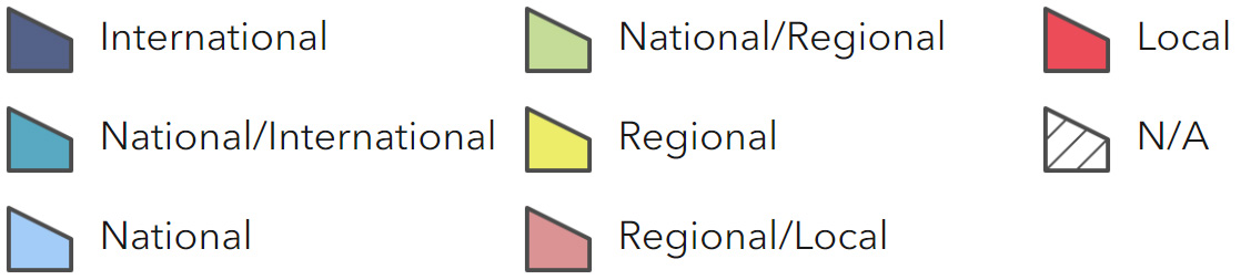
Main Beneficiaries Map
View Main Beneficiaries Map full screen in a new tab View Interactive Map HelpEcosystem service analysis
The following sections show the analysis used to determine key Ecosystem Service opportunities within the area. These opportunities have been combined with the analysis of landscape opportunities to create Statements of Environmental Opportunity. Please note that the following analysis is based upon available data and current understanding of ecosystem services. It does not represent a comprehensive local assessment. Quality and quantity of data for each service is variable locally and many of the services listed are not yet fully researched or understood. Therefore analysis and opportunities may change upon publication of further evidence and better understanding of the inter-relationship between services at a local level.
Note that numbers and figures in the body of the text are based on the 2014 profiles, unless otherwise stated.
Provisioning Services
Food provision
Assets/attributes: main contributors to service –
- Mixed agricultural land
- Soils
- Estuary
- Fisheries
State – In 2009 the total farm area was 10,764 ha. The dominant land use is grass and uncropped land accounting for 6,436 ha (60 per cent).
This is followed by cereals (1,690 ha or 16 per cent).
In 2009, 33 per cent of holdings were classed as ‘other types’ which includes holdings with only horses, with only grass or fodder crops or with only fallow land or buildings and holdings with unknown activity. This may be indicative of a high level of farm diversification.
Livestock numbers in 2009 were cattle (10,998), sheep (6,777) and pigs (247).
The Dee Estuary supports commercial fishing including an important cockle fishery.
Common or brown shrimp are caught in the shallow waters of the mouth of the Dee Estuary.
The Dee has been designated a ‘bass-nursery area’.
Main beneficiary – Regional
Analysis – Most farming is grass and uncropped land, with cattle being the most prominent livestock, followed by sheep. There are also pockets of arable land and market gardening. However, grazing by horses is also a major component of the landscape, reducing availability of land for agriculture.
Depending on soil types, warmer temperatures and reduced rainfall could lead to greater intensification and a move towards arable crops and root crops, which may lead to increased water demand and greater use of irrigation systems.
Temperature changes could affect the timing of planting and harvesting crops, for example, root crops may be left in the ground for longer.
The mosaic of both grassland and arable farmland is used by farmland birds and by waders for feeding.
Important commercial shellfish beds are found on the Dee Estuary. The cockle fishery is regulated by the Environment Agency.
Cockle harvesting is licensed, with allocation of licences for cockling determined by rules in the Dee Cockle Regulating Order. Most landing occurs on the more accessible English side of the estuary. Bass fishing is also restricted within the estuary.
Opportunities – Manage agricultural change to protect and support the landscape’s distinctive character and wildlife habitat.
Support initiatives to develop mixed agricultural systems which are economically and environmentally sustainable.
Ensure that horse paddocks are integrated into the agricultural landscape.
Provide mosaics of overwintered stubbles, spring sown cereals, buffer strips and extensively managed grass for year round bird habitat.
Conserve network of infield ponds, pond margins and pond landscapes.
Prevent agricultural nutrients and pesticides from polluting fresh water and other sources.
Sustainable management of the fisheries.
Principal services offered by opportunities –
- Food provision
- Regulating soil quality
- Regulating soil erosion
- Pollination
- Sense of place/inspiration
- Biodiversity
Timber provision
Assets/attributes: main contributors to service –
- Woodland
State – Woodland cover is relatively low at 856 ha (5 per cent). This includes 738 ha of broadleaf woodland, 53 ha of conifer woodland and 37 ha of mixed woodland.
Ancient semi-natural woodland covers 7 ha.
The Mersey Forest covers approximately half of the NCA.
Main beneficiary – Local
Analysis – Woodland cover is limited within this NCA. New woodland planting would increase opportunities for timber provision, however, planting would need to be sensitively carried out to maintain biodiversity and minimise conflict with food production.
Woodland planting is likely to be inappropriate around the mudflats and coastal salt marshes of the Dee Estuary, with the open nature of the designated area. There may be some opportunities to create small woodlands, for example, to buffer riparian zones in farmland and around appropriate urban and settlements such as playing fields, highway verges and derelict land.
There may also be opportunities to create new multi-purpose woodlands for the development of recreational links or the establishment of nature conservation areas.
Approximately half of the area is within the Mersey Forest, which has objectives to create sustainably managed community woodlands that benefit the education and health and wellbeing of communities and through the provision of woodland products.
Woodland regeneration has occurred on areas of former lowland heathland; consider woodland clearance and restoration of lowland heathland habitats in appropriate locations where this would contribute to biodiversity.
Opportunities – Seek opportunities for woodland planting in suitable locations such as to buffer riparian zones in farmland and around appropriate urban areas and settlements such as playing fields, highway verges and derelict land.
Encourage appropriate management of woodlands and the creation of new woodlands, prioritising planting to increase, buffer and link existing patches of habitat to provide multiple benefits including timber provision, sustainable wood products, wildlife conservation and recreation.
Principal services offered by opportunities –
- Timber provision
- Water availability
- Biomass energy
- Climate regulation
- Regulating water quality
- Tranquillity
- Recreation
- Biodiversity
Water availability
Assets/attributes: main contributors to service –
- Rivers and streams
- Sandstone aquifer
- Rainfall
State – The NCA overlays groundwater management units (GWMUs) consisting of major sandstone aquifers, with groundwater abstractions used for public water supply in the Mersey catchment. These have ‘restricted water available’. The only surface water resource within the NCA is Dibbinsdale Brook, which drains to the Mersey Estuary and is classed as having ‘water available’ (Lower Mersey and Alt Abstraction Licensing Strategy, Environment Agency, 2013).
The availability of surface water for abstraction in the area around the Dee Estuary has not been assessed in detail, however it is likely some surface water is available. There is no groundwater available (Dee Catchment Abstraction Licensing Strategy, Environment Agency Wales, 2013).
Main beneficiary – Regional
Analysis – The geology of the area is dominated by sandstones that are part of the Permo-Triassic sandstone aquifer. This important aquifer is used for public water supply, industrial and agricultural use.
The reason for the groundwater status ‘restricted water available’ in Wirral groundwater management units is saline intrusion, while the North West Wirral ground water unit is also over licensed. Due to a long history of heavy groundwater abstraction along the coast, saline intrusion from the Mersey Estuary is a major issue.
Opportunities – Promote the wise and efficient use of water.
Ensure that abstraction from water resources is sustainable. Conserve groundwater to prevent further saline intrusion.
Encourage new developments to incorporate permeable ground surfaces, sustainable urban drainage systems, water efficiency features and rainwater/grey water harvesting.
Principal services offered by opportunities –
- Water availability
- Regulating water quality
- Regulating water flow
- Biodiversity
Genetic diversity
Assets/attributes: main contributors to service –
- Back poplar
State – The native black poplar is a rare tree with representation in the Wirral NCA. Specimens can be found at Hallwood Farm Marl Pit Site of Special Scientific Interest (SSSI).
Main beneficiary – Local
Analysis – Historically the black poplar has been much used in hybridisation or propagated to produce, among others, the Manchester poplar, which was widely planted for its tolerance of air pollution.
The true native species, a plant of lowland flood plains, has declined through progressive clearance of habitat and surviving specimens are often isolated. Little or no seed is produced once the distance between remaining individual male and female black poplars has become too great.
Hallwood Farm Marl Pit SSSI contains one male and two female trees growing in close proximity which ensures a supply of fertile seed.
Opportunities – Consider a strategy for maintaining and increasing the population of native black poplar.
Principal services offered by opportunities –
- Genetic diversity
- Climate regulation
- Biodiversity
Biomass energy
Assets/attributes: main contributors to service –
- Farmland
- Woodland
- The Mersey Forest
State – In this NCA the existing woodland cover (5 per cent) offers low potential for the provision of biomass, either through bringing unmanaged woodland under management or as a by-product of commercial timber production.
The NCA has a predominantly medium potential yield for short rotation coppice, with some areas of low potential, while the potential miscanthus yield is predominantly high.
For information on the potential landscape impacts of biomass plantings within the NCA, refer to the tables on the Natural England website.
There are eight wood fuel boilers and one wood fuel supplier.
Main beneficiary – Local
Analysis – The Wirral has a unique character being a peninsula, with outward views from coast and sandstone ridges. Its physical characteristics lend themselves to limited biomass crop planting in low-lying areas. However, the countryside is small scale, highly valued by urban population and at the same time vulnerable to urban pressures and in practice, opportunities for planting without adverse impact in some respect, may be very limited.
Woodland regeneration has occurred on areas of former lowland heathland. Clearance and restoration of lowland heathland habitats in appropriate locations on these sites may provide small- scale opportunities for biomass.
There may be some opportunities to create small woodlands, for example, to buffer riparian zones in farmland and around appropriate urban and industrial areas and settlements such as playing fields, highway verges and derelict land. There may also be opportunities to create new multi- purpose woodlands for the development of recreational links or the establishment of nature conservation areas. Community
woodland partnerships, such as the Mersey Forest, are beginning to establish sustainable supply and demand for biomass.
Opportunities – Encourage better management of woodlands and the creation of new woodlands, prioritising planting to increase, buffer and link existing patches of habitat.
Explore opportunities for management of woodlands and scrub to produce surplus timber and biomass for local use, such as wood-fired boilers.
Seek opportunities to incorporate tree planting within farmland areas where it will improve ecosystem services underpinning food production.
Managing woodland/scrub regeneration on areas of former lowland heathland in appropriate locations may provide some biomass, while improving lowland heathland biodiversity.
Principal services offered by opportunities –
- Biomass energy
- Timber provision
- Climate regulation
- Biodiversity
Regulating Services
Climate regulation
Assets/attributes: main contributors to service –
- Soils
- Semi-natural habitats
State – In this NCA soil carbon levels are generally low, reflecting that 81 per cent of its area is covered by mineral soils which can be low in organic matter.
The area’s remaining soils, are:
- Salt marsh soils, 7 per cent of NCA.
- Sand dune soils, 4 per cent of NCA.
- Naturally wet very acid sandy and loamy soils 2 per cent of NCA.
- Loamy and clayey flood plain soils with naturally high groundwater, 3 per cent of NCA.
- Loamy and clayey soils of coastal flats with naturally high groundwater, 1 per cent of NCA.
Carbon storage is also provided to a limited extent by the area’s woodland cover (5 per cent of the NCA).
Main beneficiary – Local
Analysis – The salt marsh soils, sand dune soils, naturally wet very acid sandy and loamy soils, loamy and clayey flood plain soils with naturally high groundwater and loamy and clayey soils of coastal flats with naturally high groundwater are all likely to have organic-rich or peaty layers and can provide an important store of carbon. It is thus important to conserve these soils, especially where associated with areas of coastal and flood plain grazing marsh, lowland heathland and the Dee estuary’s intertidal mud and silts.
Any climatic changes that put soils under stress will impact on carbon storage potential. A switch from livestock to arable production will increase soil disturbance and will impact on carbon stores.
Carbon storage is also provided to a limited extent by the area’s woodland cover, especially where brought under sustainable management.
Opportunities – Seek opportunities to restore and expand semi- natural habitats such as coastal and flood plain grazing marsh and wetland and grassland habitats and bring them under sympathetic management to increase carbon storage.
Work with the farming community to ensure best practice in soil management, adopting cultivation practices that retain the organic content of soils, thereby facilitating carbon retention as well as reducing soil erosion.
Principal services offered by opportunities –
- Climate regulation
- Regulating soil quality
- Regulating soil erosion
- Biodiversity
Regulating coastal erosion and flooding
Assets/attributes: main contributors to service –
- Estuaries and associated habitats
- Wide sandy/muddy beaches
- Coastal cliffs
State – The coastal frontage of the Wirral peninsula is located between the River Mersey to the east and the Dee Estuary to the west, with the North Wirral coastline facing north-north-west into Liverpool Bay and the Irish Sea.
A number of public and privately maintained defences act to fix the position of the shoreline in some locations.
Much of the coastline of the Dee Estuary and North Wirral Foreshore are internationally designated as Special Area of Conservation (SAC), Special Protection Area (SPA) and Ramsar site to protect the extensive intertidal mudflats and sand flats and coastal salt marshes and the numerous waterfowl that use the habitat.
There are sections of eroding cliff near Thurstaton that are also designated Site of Special Scientific Interest (SSSI).
There is tidal flood risk at several locations around the Wirral peninsula, which can arise from high water levels and from wave action. There are tidal defences for many of the areas at risk.
Main beneficiary – Regional
Analysis – The main urban areas along the Dee Estuary frontage within this NCA are West Kirby, Heswall and Neston. The long-term plan is to continue to manage risks to commercial and industrial assets from flooding and erosion, but to also allow more natural evolution where appropriate. In order to mitigate the impacts of the defences on the evolution of the estuary in combination with expected long-term future sea level rise, a number of areas with potential for managed realignment have been identified. It was not, however, deemed appropriate to propose managed realignment as the headline policy in the Shoreline Management Plan in these locations in the short term until a suitable plan for delivering this realignment has been developed and all the potential options have been reviewed with stakeholders (North West England and North Wales Shoreline Management Plan SMP2 -main document and Mersey Estuary (Unit 11a 7), North West & North Wales Coastal Group, 2010).
The northern Wirral coastline is significantly influenced by the Dee and Mersey estuaries at either end of the frontage. Coastal sand dunes and the wide sandy foreshore have formed along the length of the frontage. Coastal sand dunes provide a natural barrier to sea flooding. They provide natural protection to coastal settlements, including Hoylake, Moreton and Leasowe within this NCA, as well as coastal recreational sites.
The whole frontage is currently defended, with the long term plan, subject to more detailed investigations, to continue to provide flood and erosion protection to the residential areas, infrastructure and low lying land along the frontage (North West England and North Wales Shoreline Management Plan SMP2 – main document and Mersey Estuary (Unit 11a 7), North West & North Wales Coastal Group, 2010).
Erosion of the soft cliffs is important to maintaining their geological, faunal and floral interest (including Dee Cliffs SSSI), but is viewed as unacceptable to some coastal landowners. The Red Rocks shoreline is currently accreting rapidly to form new salt marsh and sand dunes. Similar accretion along the North Wirral Foreshore is contentious in the local community, regarded by some as a problem and by others as an opportunity for new soft sea defences and habitat.
Opportunities – Promote research towards gaining a deeper understanding of coastal sedimentary systems to aid the prediction of the likely effects of sea-level rise.
Work with partners to find solutions that enable dynamic coastal processes to function as naturally as possible particularly where this supports and enhances natural flood defence mechanisms and allows for the conservation of important wildlife habitats, while taking into account the need to protect key facilities on the peninsula.
Work with local landowners to find ways of adapting to coastal change where maintaining defences is not sustainable.
Principal services offered by opportunities –
- Regulating coastal erosion and flooding
- Regulating soil erosion
- Sense of place/inspiration
- Recreation
- Biodiversity
- Geodiversity
Regulating water quality
Assets/attributes: main contributors to service –
- Rivers and streams
- Sandstone aquifer
- Rainfall
- Semi-natural habitats
State – For information regarding the current state of water quality within this NCA, refer to the Environment Agency (Draft river basin management plan maps).
Main beneficiary – Regional
Analysis – The Dee River Basin District covers an area of 2,251 km2, mainly in Wales but including a small area in England. Its source is in the mountains and lakes of the Snowdonia National Park. Chester and Wrexham are the major urban centres, but the land is mainly rural with rough grazing and forestry in the upper catchment and arable and dairy farming on the Cheshire Plain.
The main reasons why water bodies in the Dee River Basin District are not in a good condition relate to issues such as physical modifications and diffuse pollution from rural areas (Dee River Basin District: Challenges and choices – Facts and statistics, Natural Resources Wales, 2013). Excessive nutrients (especially phosphate) are identified as a particular problem in some lower tributaries of the Dee catchment, due to a combination of agricultural land practices associated with cattle farming and waste water discharges.
Use of buffer strips or tree planting in appropriate locations along watercourses and in the wider catchment could help to reduce diffuse pollution and sedimentation. Cockle gathering in the Dee estuary is susceptible to contamination from wastewater treatment discharges.
Water quality at a bathing water is dependent upon the type and area of land (the catchment) draining to the water and the activities undertaken in that catchment. Bathing water quality is sampled by the Environment Agency and is generally meeting or exceeding minimum standards.
Opportunities – Work with landowners and managers on water quality issues that have been identified. Possible approaches include fencing riverside zones to exclude livestock from rivers and capture diffuse sediment and nutrient pollution; adjusting numbers of livestock to reduce field erosion; promoting the use of cover crops to reduce erosion and retain soil nutrients; identifying and improving farmyard infrastructure (improving slurry storage, separating ‘clean’ and ‘dirty’ water); developing nutrient management plans that save money and protect the environment; and reducing reliance on chemical fertilisers, pesticides and herbicides.
Manage and extend areas of permanent grassland, scrub and woodland along watercourses where appropriate.
Work with water companies to reduce the level of nutrients and other pollutants discharged into watercourses and ensure sewage discharges are treated appropriately.
Principal services offered by opportunities –
- Regulating water quality
- Food provision
- Water availability
- Regulating water flow
- Recreation
- Biodiversity
Regulating water flow
Assets/attributes: main contributors to service –
- Rivers and streams
- Coast
- Estuary
- Rainfall
- Semi-natural habitats
State – This NCA is bounded to the north by Liverpool Bay and to the west by the Dee Estuary. Its north-eastern part contains some tributary streams that drain to the Mersey Estuary, including the River Birket, which creates some flood risk at Hoylake within the NCA.
The south-western part of the NCA contains streams draining to the Dee estuary, but these do not give rise to significant fluvial flood risk.
Tidal flood risk is covered below under ‘Regulating coastal erosion and flooding’.
Main beneficiary – Local
Analysis – Wetter winters and more severe storm events are likely to lead to increased surface water. This may be of particular concern in communities such as Holywell and Neston where such flooding is already an issue (River Dee Catchment Flood Management Plan, Environment Agency Wales, 2010).
Tidal levels can restrict the outflows from watercourses and drainage systems and exacerbate flooding behind defences.
Storing water or managing run- off can provide overall flood risk reduction or environmental benefits, locally or elsewhere in the catchment. This supports sustainability by reducing the risk from flooding to people and property, and in turn transferring the risk to locations where it can be beneficial. There are opportunities to create storage areas on the Wirral (both on and off line) in order to reduce flood risk in areas located downstream.
Sustainable land management practices can reduce the amount and rate of run-off and erosion.
Opportunities – Encourage the use of appropriately designed sustainable urban drainage systems (SUDS) to control run-off at source.
Look for opportunities to create flood water storage areas on the Wirral (both on and off line) in order to reduce flood risk in areas located downstream and provide other environmental benefits such as habitats for wildlife.
Encourage good management of agricultural soils to improve water infiltration rates, slow run-off and increase water-holding capacity.
Seek opportunities to restore and extend semi-natural habitats such as flood plain grassland and woodland to improve water storage capacity and infiltration and slow run-off while improving habitat networks and ecosystem resilience to climate change.
Encourage tree planting in appropriate locations and hedgerow restoration to help slow run-off into rivers.
Principal services offered by opportunities –
- Regulating water flow
- Water availability
- Regulating water quality
- Regulating soil quality
- Biodiversity
Regulating soil quality
Assets/attributes: main contributors to service –
- Soils
- Semi-natural habitats
State – There are eight main soilscape types in this NCA:
- Slowly permeable seasonally wet slightly acid but base-rich loamy and clayey soils, covering 50 per cent of the NCA.
- Slightly acid loamy and clayey soils with impeded drainage (16 per cent).
- Freely draining slightly acid sandy soils (15 per cent).
- Salt marsh soils (7 per cent).
- Sand dune soils (4 per cent).
- Loamy and clayey flood plain soils with naturally high groundwater (3 per cent).
- Naturally wet very acid sandy and loamy soils (2 per cent).
- Loamy and clayey soils of coastal flats with naturally high groundwater (1 per cent).
Main beneficiary – Local
Analysis – The slowly permeable seasonally wet slightly acid but base-rich loamy and clayey soils may suffer compaction and/or capping as they are easily damaged when wet. In turn this may lead to increasingly poor water infiltration and diffuse pollution as a result of surface water run- off. Management measures that increase organic matter levels can help reduce these problems.
Similarly, the slightly acid loamy and clayey soils with impeded drainage have a weak topsoil structure that can easily be poached by livestock and compacted by machinery when wet. Careful timing of activities is required to reduce this likelihood.
The freely draining slightly acid sandy soils allow water infiltration and have potential for increased organic matter levels through management interventions. They may be valuable for aquifer recharge, requiring the maintenance of good structural conditions to aid water infiltration and requiring the matching of nutrients to needs to prevent pollution of the underlying aquifer.
Opportunities – Work with the farming community to ensure best practice in soil management to improve structure and quality of soils. This may be achieved through actions such as using low pressure machinery and managing stock movements, where necessary fencing watercourses and providing drinking bays to prevent bankside erosion from livestock access.
Principal services offered by opportunities –
- Regulating soil quality
- Food provision
- Regulating water quality
- Regulating water flow
- Regulating soil erosion
Regulating soil erosion
Assets/attributes: main contributors to service –
- Soils
- Semi-natural habitats
- Geomorphological processes
State – There are eight main soilscape types in this NCA:
The slowly permeable seasonally wet slightly acid but base-rich loamy and clayey soils (50 per cent of the NCA), loamy and clayey flood plain soils with naturally high groundwater (3 per cent), and loamy and clayey soils of coastal flats with naturally high groundwater (1 per cent) are of low risk of erosion.
Soils at risk or erosion include slightly acid loamy and clayey soils with impeded drainage (16 per cent); freely draining slightly acid sandy soils (15 per cent); salt marsh soils (7 per cent); sand dune soils (4 per cent); and naturally wet very acid sandy and loamy soils (2 per cent).
Main beneficiary – Local
Analysis – Slightly acid loamy and clayey soils with impeded drainage are prone to capping/slaking, leading to increased risk of erosion. These soils are easily compacted by machinery or livestock if accessed when wet, increasing risks of water erosion. This is particularly an issue on the steeper land.
Freely draining slightly acid sandy soils are of enhanced risk of soil erosion especially on moderately or steeply sloping land where cultivated or bare soil is exposed. This is exacerbated where organic matter levels are low after continuous arable cultivation or where soils are compacted. There is also potential for wind erosion where these soils are cultivated or left bare especially in spring.
Factors affecting soil erosion are complex. The location of habitats and other land cover has an impact on the management of soil erosion. Measures may be beneficial where they retain water in situ, ensure good vegetative cover and avoid over-grazing/ trampling or damage by mechanised activities.
Coastal salt marsh can dissipate wave energy and reduce the level of flooding. Erosion and re-deposition processes in coastal salt marshes are necessary to maintain a succession of diverse habitats.
Sand dune soils are characteristically very droughty and unstable. Erosion and re-deposition processes in dunes are necessary to maintain a succession of diverse habitats. Younger less vegetated dunes constantly change shape.
Opportunities – Maintain good soil structural condition through well-timed cultivations and access onto land by machinery and stock to prevent compaction and poaching.
Consider use of buffer strips to prevent sediment polluting watercourses or impacting on adjoining land, particularly on the most vulnerable soils.
Encourage opportunities to manage and extend habitats including woodland and riparian habitats in appropriate locations, such as near watercourses to prevent or capture sediment run-off and improve infiltration.
Take measures to keep soil in-situ, such as contour ploughing where sloping. Where soils are eroding land use change may be necessary (for example, from arable to grass). Ensure good vegetative cover, avoiding over grazing/ trampling or damage from mechanised activities. On the most vulnerable soils consider use of windbreaks, rough seedbeds, nurse crops and planted straw to reduce wind erosion.
Understand soil changes that will take place in event of sea water rise/flooding and subsequent impact on land use and inland movement of the coastal salt marsh system.
Enable natural movement of coastal sand dune habitats.
Principal services offered by opportunities –
- Regulating soil erosion
- Regulating soil quality
- Food provision
- Regulating water flow
- Regulating water quality
- Regulating coastal erosion and flooding
- Biodiversity
Pollination
Assets/attributes: main contributors to service –
- Semi-natural habitats
- Farmland
State – The NCA contains relatively little high-quality habitat to support pollinating insects, with the exception of its lowland heathland. This will provide some nectar source for pollinating insects as do some boundary features such as the hedgerows and species-rich road verges.
Main beneficiary – Local
Analysis – Pollinators play a role in food provision, through pollinating crops such as oilseeds and fruit.
Heathland, woodland and grassland habitats provide habitats for pollinating insects and should be managed in good condition and expanded where possible to ensure this service continues effectively.
Providing suitable nectar sources and the habitat structures required for pollinating insects should help to enable pollination
Opportunities – Provide feeding, breeding and hibernation habitat for pollinators and beneficial predator species by maintaining, restoring and creating habitats, such as lowland heathland and species rich grassland.
Enhance management and restoration of boundary features such as hedgerows and provide species-rich road verges for nectar provision and vegetation structure for pollinators.
Principal services offered by opportunities –
- Pollination
- Food provision
- Sense of place/inspiration
- Biodiversity
Pest regulation
Assets/attributes: main contributors to service –
- Semi-natural habitats
- Farmland
State – The habitats in the area, such as hedgerows, grassland and lowland heathland can support a variety of species including predators of pest species.
Main beneficiary – Local
Analysis – There is some evidence to suggest that certain habitats (such as hedges and unimproved grassland) can support populations of beneficial predator species which can help control common agricultural pests (for example, ladybirds can control aphids) (Ecosystem Services from Environmental Stewardship that Benefit Agricultural Production, Natural England, 2012).
Opportunities – A stronger and wider network of semi natural habitats would bring benefit for pest regulation, as well as pollination and biodiversity services.
Principal services offered by opportunities –
- Pest regulation
- Food provision
- Pollination
- Biodiversity
Cultural Services
Sense of place/inspiration
Assets/attributes: main contributors to service –
- Semi-natural habitats
- Geology and local building materials
- Coast and estuary
State – Sense of place is supported both from the peninsula coastline and the small scale mosaic of fields and villages connected by a network of lanes lined with red sandstone houses and country estates.
Senses of inspiration and escapism, although constrained to some extent by urban development, are provided by the area’s coastline of coastal salt marshes, sand flats and coastal sand dunes, with Hilbre Island providing a particularly reflective location for those crossing a low tide.
In addition, the area’s picturesque sandstone outcrops, parkland and estates, and long views over the Dee and Mersey to surrounding NCAs.
Main beneficiary – Regional
Analysis – The coastal strip along the Dee estuary and north Wirral Foreshore is characterised by extensive areas of intertidal sand flats, mudflats, coastal salt marshes and coastal sand dunes. These areas are internationally important for populations of waterbirds.
Inland, the area is characterised by a mosaic of former large country estates, parks and mixed farmland, with areas of improved pasture, arable farming, market gardening and growth of nursery stock.
There are a series of country parks and Local Nature Reserves, including Hilbre Island, providing opportunities for people to enjoy the natural environment and landscape, while semi-natural habitats include extensive areas of lowland heathland and mixed woodland.
Many traditional buildings are of local red sandstone with some older structures in half timber.
In some locations there are expansive views across the landscape and towards the Welsh coastline.
Opportunities – Protect the distinctiveness of coast and estuary, with its internationally important habitats and species.
Improve public understanding and support for the many features and functions of the estuary and coast including the active geomorphological processes and wildlife value.
Seek opportunities to encourage appropriate access to natural environments, and to promote the calming and restorative effect that contact with tranquil, sensory and inspirational environments have on visitors’ health and wellbeing.
Provide networks of green infrastructure with accessible natural green spaces for people close to where they live and work.
Ensure that tourism and leisure activities are conducted in an environmentally sustainable manner, providing interpretative and educational material and facilities.
Maintain and enhance the mosaic of semi-natural habitats including lowland heathland and wetland habitats.
Respect local settlement patterns and building materials to avoid the loss of historic evidence in the landscape.
Maintain and enhance open and expansive views of the landscape.
Maintain and enhance the mosaic of semi-natural habitats including lowland heathland and wetland habitats.
Respect local settlement patterns and building materials to avoid the loss of historic evidence in the landscape.
Maintain and enhance open and expansive views of the landscape.
Principal services offered by opportunities –
- Sense of place/inspiration
- Sense of history
- Tranquillity
- Recreation
- Biodiversity
- Geodiversity
Sense of history
Assets/attributes: main contributors to service –
- Archaeological and historic features
- Geodiversity
- Cultural influences
State – Many historic field ponds, or ‘pits’ as they are often referred to locally, still remain as prominent features within the farmed landscape. Tower mills (a type of windmill) and the remains of mills (mill mounds) are quite a distinctive feature of the Wirral, reflecting a thriving arable economy in the 18th and 19th centuries.
The remains of early nucleated settlement and the vestiges of townfield agriculture can still be detected along the peninsula.
The former port at Parkgate was a principal producer of shrimps.
18th- and 19th-century development is prevalent, consisting of a mix of large country houses and estates bounded by red sandstone walls, and towns and villages which act as dormitory settlements to workers from adjacent industrial areas.
Country houses and estates including Burton Manor, Thornton Manor and Ness Botanic Gardens.
There are 5,000-year-old submerged remains of a post- glacial forest on the Meols foreshore.
Main beneficiary – Regional
Analysis – The history of the landscape is evident in the area’s strong links to livestock farming and fishing. Protecting links with the past and enhancing our understanding of these will help strengthen the character of the area.
Settlements and buildings are aspects of history that are likely to be particularly evident to the general public, as are the area’s country houses and estates, which developed in the early 19th century based on the wealth generated in Liverpool and aided by improved ferries and rail services.
There is evidence of settlement in the Roman period, while some place names indicate Norse presence in Wirral.
The 5,000-year-old submerged remains of a post-glacial forest on the Meols foreshore indicate that much of the Wirral at that time was some distance from the coast. Subsequent changes in sea level present the potential for the preservation of terrestrial landscapes beneath the extensive intertidal mudflats and sand flats of the Dee Estuary.
Deposits (especially those formed in the Dee estuary) have the potential to preserve a wide range of archaeological features and structures such as the remains of abandoned or wrecked boats or fish traps.
Opportunities – Opportunities to manage the NCA’s agricultural, coastal, estuarine and lowland heathland landscapes for the sense of history they provide.
Opportunities for sustainable recreation and tourism relating to history, ensuring that the area remains in suitable condition.
Record coastal archaeological sites that are at risk of loss through coastal erosion.
Seek to improve understanding of historic features and cultural heritage through improved interpretation and educational information, particularly associated with the development of the landscape.
Principal services offered by opportunities –
- Sense of history
- Regulating coastal erosion and flooding
- Sense of place/inspiration
- Tranquillity
- Recreation
- Biodiversity
- Geodiversity
Tranquility
Assets/attributes: main contributors to service –
- Long, distant sea views towards and from the coastline
- Semi-natural habitats
State – Tranquillity has declined significantly in the past 50 years, with the total area of the NCA classified as ‘undisturbed’ having decreased from just under 14 per cent in the 1960s to 1 per cent in 2007 (CPRE Intrusion Map, Campaign to Protect Rural England, 2007).
Main beneficiary – Local
Analysis – Only two small ‘undisturbed’ pockets remain, the first lying along the River Dee in the south-west corner of the NCA and the second east of Burton.
There are pockets of more tranquil landscapes often associated with open spaces.
A sense of tranquillity is likely to be associated with the area’s coastline of coastal salt marshes, sand flats and coastal sand dunes, as well as its small areas of mixed woodland, picturesque sandstone outcrops, parkland and estates.
The area around the M53 corridor provides break between the built-up areas of eastern and central Wirral. The highly urban areas of the Merseyside Conurbation and the Mersey Valley are adjacent to Wirral NCA. The close proximity of urban, rural and coastal landscapes leads to high public pressure on the coastal and rural areas, but also great need for the facilities they provide. However, visitor pressure can threaten sensitive habitats, species and landscape features and therefore needs to be managed appropriately.
Opportunities – Protect landscape features which contribute to sense of tranquillity, such as the area’s coastline of coastal salt marshes, sand flats and coastal sand dunes, as well as its small areas of mixed woodland, sandstone outcrops, parkland and estates.
Promote the calming and restorative effect that contact with tranquil and sensory environments has on peoples’ health and wellbeing.
Encourage sensitive development respecting long and open viewpoints and the character of the area.
Carefully ensure that light spill is minimised through lighting design in new developments to minimise the impact on dark skies.
Carefully manage recreation and access opportunities in a way that enables quiet enjoyment, while conserving habitats species and landscape features.
Principal services offered by opportunities –
- Tranquillity
- Sense of place/inspiration
- Recreation
- Biodiversity
Recreation
Assets/attributes: main contributors to service –
- Public rights of way network
- Wirral Way Country parks
- Local Nature Reserves
- Seaside resorts and coastline
State – Recreation is supported by the area’s 160-kilometre rights of way network (with a density of 0.97 km per km2), as well as 146 ha of open access land (just 0.9 per cent of the NCA), while a small proportion of the NCA (271 ha) forms part of The Mersey Forest.
Routes include the Wirral Way, which forms part of Wirral Country Park. This is a 19-kilometre path in Wirral and runs from West Kirby to Hooton. Recreation is also supported by the cycle route network, with Sustrans cycle routes and the Wirral Circular Trail.
Country parks (North Wirral Coastal Park, Royden Park, Arrowe Country Park and Wirral Country Park) and Local Nature Reserves (Burton Mill Wood, Heswall Dales, Thurstaston Common, Hilbre Islands).
The area is known for its coastal recreation, has several golf courses adjacent to coastal settlements and is of outstanding ornithological interest.
There are designated bathing beaches at West Kirby, Meols and Moreton.
Main beneficiary – Regional
Analysis – Coastal areas are popular visitor destinations. Local Nature Reserves and country parks provide opportunities for people to enjoy the natural environment.
The highly urban areas of the Merseyside Conurbation and the Mersey Valley are adjacent to Wirral NCA. The close proximity of urban, rural and coastal landscapes leads to high public pressure on the coastal and rural areas, but also great need for the facilities they provide. The provision of networks of green infrastructure, creating a high-quality environment can improve resilience to climate change, support biodiversity, provide recreational and educational opportunities, enhance the landscape, create local routes for walking and cycling, and provide accessible natural green spaces for people close to where they live and work.
There are recreational opportunities such as walking associated with the footpath network, including the Wirral Way. Appropriate access can enhance visitors experience, increase their understanding of the local environment and lead to improvements in health and wellbeing. However, visitor pressure can threaten sensitive habitats, species and landscape features if not managed appropriately.
The England Coast Path, a new National Trail, will give people the right of access around England’s entire open coast, including spreading room, where appropriate.
Wirral NCA and the Dee Estuary share a border with Wales. There are opportunities to ensure that cross-border links for pedestrians and cyclists are continuous.
The coastal and estuarine landscape offers opportunities for recreation associated with wildlife, such as birdwatching.
The archipelago of three islands, Little Eye, Middle Eye and Hilbre Island are located approximately 1 km from high water mark at the town of West Kirby, The islands are connected to the mainland at low tide, when they can be accessed by foot. This is a popular activity, especially in the summer months.
Recreational activities have the potential to disturb breeding birds and high tide roosting sites at which large bird populations concentrate.
Opportunities – Protect and enhance the quality of recreational facilities and access opportunities for users of all abilities, particularly at the coast, country parks and Local Nature Reserves, while seeking to minimise disturbance, particularly to bird populations and designated sites.
Seek opportunities to enhance the rights of way and cycle route network, promoting sustainable access routes that contribute to people’s health and wellbeing, improve people’s understanding of the area and link public footpaths and settlements while conserving the area’s sensitive habitats, species and landscape features.
Provide networks of green infrastructure to enable recreational and educational opportunities, enhance the landscape, create local routes for walking and cycling and provide accessible natural green spaces for people close to where they live and work.
Support the development of a successful England Coast Path that encourages better public access and is sensitive to the features that are found on or along the coast. Seek to provide the best and most continuous cross-border links for pedestrians and cyclists, in relation to the England Coast Path, the Welsh Coast Path and other routes.
Promote interpretation to help visitors and local people gain an improved awareness and understanding of the key nature conservation features within the area.
Ensure tourism and recreational activities are carried out in a sustainable manner, reducing recreational disturbance by careful management of activities.
Seek opportunities to improve water quality for the benefit of wildlife and recreational users in the area by working with water companies, industry, farmers, fishermen and local residents to minimise diffuse and point-source pollution.
Principal services offered by opportunities –
- Recreation
- Sense of place/inspiration
- Sense of history
- Tranquillity
- Biodiversity
- Geodiversity
Biodiversity
Assets/attributes: main contributors to service –
- Coast
- Habitats
- Species
- Rivers, ponds and wetlands
State – Priority habitats within the NCA include 469 ha of coastal and flood plain grazing mars, 286 ha broadleaved mixed and yew woodland (broad habitat), 106 ha of lowland heathland, 89 ha coastal sand dunes, 54 ha mudflats, 35 ha lowland meadows, 13 ha maritime cliff and slope, 9 ha reedbeds and 8 ha lowland dry acid grassland.
The NCA includes one Special Area of Conservation (SAC), two Special Protection Areas (SPAs) and two Ramsar sites, while 1,500 ha are nationally designated as Site of Special Scientific Interest (SSSI).
23 Local Wildlife Sites covering 140 ha.
The mosaic of farmland provides a feeding resource for birds.
The rural area supports wide- ranging species including bats, brown hare and barn owl.
Main beneficiary – International
Analysis – The coast and estuary is one of the NCA’s primary wildlife assets, with significant internationally, nationally and locally recognised wildlife and habitats.
The Dee Estuary and North Wirral Foreshore supports extensive areas of mudflats, sand flats, coastal salt marsh and coastal and flood plain grazing marsh, with internationally important numbers of wildfowl and waders. The coastal and flood plain grazing marshes bordering the Dee Estuary attract wetland birds in large numbers and represent important refuges for estuarine species at times of severe weather.
There are small fragments of coastal sand dunes. A diverse range of plant and animal communities occur including populations of natterjack toads.
The coastal habitats and species (SPA, SAC, Ramsar and SSSI) will be at risk from sea level rise. Natural regeneration/migration where appropriate and/or creating compensation habitats in areas of managed realignment will help ensure no net loss of habitat.
The Dee Estuary forms an essential part of the route of migratory fish species, which have their breeding grounds upstream in the River Dee (River Dee and Bala Lake SAC). Species present include Atlantic salmon, sea trout, smelt, twaite shad and eels as well as sea lamprey and river lamprey.
The coastal zone is dynamic. The salt marsh between Parkgate and Heswall is still accreting.
Cliff recession is a natural process. Maritime cliffs and slopes are sensitive to erosion caused by increased rainfall which could result in more vertical slopes and more rapid retreat of coastal soft cliffs.
Large tracts of lowland heathland occur on sandy hills in Wirral.
A great number of birds, particularly waders like curlew and pink-footed goose rely on both grass and arable farmland areas as a source of food. The key areas for wading bird use on the Wirral are located on and to the west of the mid-Wirral sandstone ridge.
These areas are also important for populations of farmland birds including skylark linnet, yellowhammer and tree sparrow.
Ponds and hedgerows may serve as habitat ‘stepping stones’ or corridors, assisting local wildlife migrations and increasing the variety of species on farmland and in urban areas.
Opportunities – Maintain biodiversity habitats and, where appropriate, enhance the extent, distribution and quality of the most important and characteristic types.
Promote the recovery of degraded habitats.
Ensure that coastal processes are allowed to function as naturally as possible allowing the formation of intertidal flats, coastal salt marshes and coastal sand dunes to proceed, thereby maintaining the coastal habitats and visiting bird populations of international importance.
Avoid any potential net loss of habitat from ‘coastal squeeze’ by seeking opportunities for habitat creation, including realignment schemes to create coastal habitats such as coastal salt marsh or other wetland habitats.
Ensure connecting links are provided between the estuary and inland areas. Maintain migratory routes for fish species such as sea and river lamprey, ensuring that their passage is unobstructed by physical barriers or poor water quality.
Redevelop the natural transitions between intertidal sand flats/mudflats, foreshore, coastal salt marsh, freshwater marsh, coastal sand dune, grassland and lowland heathland communities.
Introduce appropriate management to sustain lowland heathland communities, giving due regard to individual habitat features such as patches of bare ground which are required by some species.
Where feasible, re-establish habitat links between adjacent lowland heathland sites.
Maintain, restore or create lowland meadow, lowland heathland, acid grassland and other semi-natural and species-rich grassland.
Maintain, restore or create wet grassland habitat for breeding birds.
Maintain areas of grass and arable farmland for birds.
Conserve and restore network of infield ponds ‘marl pits’, pond margins and pond landscapes. Conserve and restore hedgerows.
Use nature reserves and other local green spaces, to encourage communities to become more involved in biodiversity close to where they live and work, taking part in biological recording through events such as bio-blitz, and by volunteering to be involved in site based conservation activities and in the future planning and management of these sites.
Principal services offered by opportunities –
- Biodiversity
- Water availability
- Climate regulation
- Regulating soil erosion
- Regulating coastal erosion and flooding
- Sense of place/inspiration
- Recreation
- Geodiversity
Geodiversity
Assets/attributes: main contributors to service –
- Geomorphological processes
- Geological exposures
State – Three geological Sites of Special Scientific Interest (SSSI) and nine Local Geological Sites.
The geology of the Wirral peninsula is dominated by glacial till overlying Triassic sandstone.
The eastern shore of the Dee Estuary is backed by a stretch of till cliffs between Heswall and Hoylake.
The cliffs are of geological and geomorphological importance for their sedimentary record and display of natural erosive processes. They are also of biological importance, particularly for their plant communities.
The Triassic sandstones have historically been quarried for building stone.
Main beneficiary – Regional
Analysis – Natural coastal erosion is prevalent on the soft cliffs and the presence of slumped material is common. Soft cliffs supply sedimentary material and therefore perform an important coastal processes role.
Geological sites provide opportunities to interpret the local geodiversity, helping to inform and educate visitors and increasing their understanding and enjoyment. These sites also allow continued research into the geodiversity of the NCA.
The relative isolation of the Wirral peninsula has ensured that pre 19th-century building stone had limited sources. The pink hues of the local red stone bring warmth to the landscape and provide a unifying theme in buildings, walls and bridges.
Opportunities – Allow the natural dynamic processes that affect both the estuary and coastline. Provide interpretation of the dynamic processes underway in the estuary and along the coast, to improve understanding and enjoyment.
Maintain the integrity of geological and landform features within the area and enhance their value for interpretation, education and visual amenity. Ensure that significant geological and landform features are sufficiently documented and protected to enable the continued study of Wirral’s geodiversity.
Provide access to sites of geological interest, where appropriate, and interpret the geological features, to improve understanding and enjoyment.
Maintain vernacular buildings and stone walls where possible to reinforce links with the underlying geology and strengthen sense of place.
Principal services offered by opportunities –
- Geodiversity
- Regulating coastal erosion and flooding
- Sense of place/inspiration
- Sense of history
- Tranquillity
- Recreation
- Biodiversity