

National Character Area 156
West Penwith - Analysis: Ecosystem Services
Analysis supporting Statements of Environmental Opportunity
The following analysis section focuses on a selection of the key provisioning, regulating and cultural ecosystem goods and services for this NCA. These are underpinned by supporting services such as photosynthesis, nutrient cycling, soil formation and evapo-transpiration. Supporting services perform an essential role in ensuring the availability of all ecosystem services.
Bodiversity and geodiversity are crucial in supporting the full range of ecosystem services provided by this landscape. Wildlife and geologically-rich landscapes are also of cultural value and are included in this section of the analysis. This analysis shows the projected impact of Statements of Environmental Opportunity on the value of nominated ecosystem services within this landscape.
Further analysis on landscape attributes and opportunities for this NCA is contained in the Analysis: Landscape Attributes & Opportunities section.
Natural Capital
Further information on Natural Capital within this NCA is contained in the Natural Capital and Key Ecosystem Services section.
The West Penwith NCA provides a wide range of benefits to society. Each is derived from the attributes and processes (both natural and cultural features) within the area. These benefits are realised through the ‘ecosystem services’ that flow from the ‘ecosystem assets’ or ‘natural capital’ of a place.
Natural capital means ‘the elements of nature that directly or indirectly produce value to people, including ecosystems, species, freshwater, land, minerals, the air and oceans, as well as natural processes and functions’ (Natural Capital Committee, 2017).
Ecosystem Services Main Beneficiaries
The below map displays the main beneficiaries of each ecosystem service identified within this NCA and neighbouring NCAs. These range from being of international importance to local importance. Some services have not been assessed within all NCAs, and therefore in some NCAs are displayed as “N/A” (not applicable).
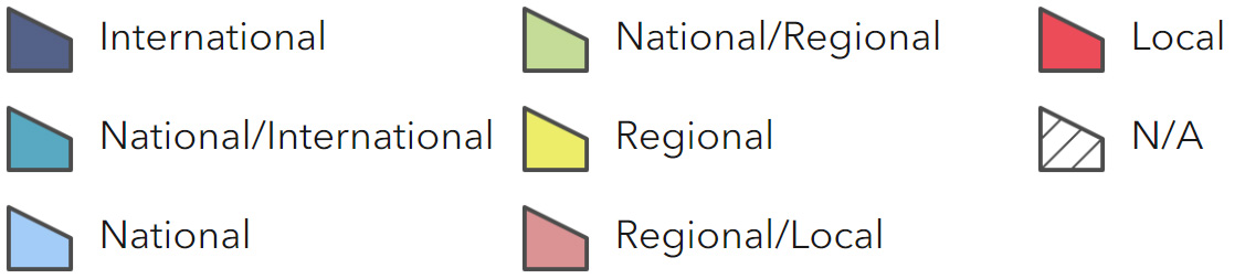
Main Beneficiaries Map
View Main Beneficiaries Map full screen in a new tab View Interactive Map HelpEcosystem service analysis
The following sections show the analysis used to determine key Ecosystem Service opportunities within the area. These opportunities have been combined with the analysis of landscape opportunities to create Statements of Environmental Opportunity. Please note that the following analysis is based upon available data and current understanding of ecosystem services. It does not represent a comprehensive local assessment. Quality and quantity of data for each service is variable locally and many of the services listed are not yet fully researched or understood. Therefore analysis and opportunities may change upon publication of further evidence and better understanding of the inter-relationship between services at a local level.
Note that numbers and figures in the body of the text are based on the 2014 profiles, unless otherwise stated.
Provisioning Services
Food provision
Assets/attributes: main contributors to service –
- Small dairy farms
- Specialist arable crops
- Fishing
State – Small dairy farms and an extensive range of meat products, some specialist arable crops (vegetables) are grown. Intensive early vegetable productions accounts for 10 per cent of the area producing potatoes, cauliflowers and other high-end value early crops.
The fishing industry still has a significant base within the NCA at Newlyn.
80 per cent of registered land is classified as used for grazing or un-cropped managed predominantly by cattle grazing.
Main beneficiary – Regional
Analysis – The wet and warm Atlantic climate is conducive to a long growing season which is reflected in the stock husbandry regime of animals being ‘out’ for a much greater proportion of the year.
A relatively small farm size and mixed agriculture system (beef, dairy and sheep) means that margins are very low and expansion is difficult.
Food production from a rough pastoral farming landscape is a key service in this area. The levels, type and quality of food produced reflect the area. The favourable climatic conditions allow the early production of vegetables.
Changes in climate and weather patterns may challenge the traditional outputs from the area, but new opportunities may also arise. Maintaining current high levels of outputs, particularly high value vegetables, will have an ongoing impact on soil structure and condition and may speed rates of soils erosion.
Food provision is intrinsically linked to the cultural and some tourist services of West Penwith underpinning and promoting a strong sense of place and the range of biodiversity in this area.
Opportunities – Work with the local farming/rural community to consider how to increase the overall productivity of agricultural systems within West Penwith, seeking to increase the commercial value of associated foodstuffs while avoiding adverse impacts within the NCA and on other ecosystem services.
Develop markets that reduce the export of landed fish.
Principal services offered by opportunities –
- Food provision
- Biodiversity
- Regulating soil erosion
- Regulating soil quality
- Regulating water quality
- Sense of place/inspiration
- Sense of history
Timber provision
Assets/attributes: main contributors to service –
- Small woodlands
State – Small oak and sycamore woodlands exist in the southern part of the NCA and in many of the valleys leading from the moor to the sea.
A mix of management is seen in these woods.
Main beneficiary – Local
Analysis – The area is not known for its timber resource and woodland is not a significant feature, only covering 4% of the NCA.
Many of the woodlands are showing signs of neglect and this is decreasing their value.
Opportunities – Opportunities should be considered to maximise the biodiversity and economic values of these woodlands through the introduction of sympathetic management.
An increase in woodland would contribute to soil quality and carbon storage but opportunities may be limited in the NCA.
Principal services offered by opportunities –
- Timber provision
- Biodiversity
- Regulating water quality
- Regulating water flow
- Sense of place/inspiration
- Regulating soil quality
- Climate regulation
Water availability
Assets/attributes: main contributors to service –
- Small rivers and streams
- Ponds
- Drift Reservoir
State – Small rivers and streams rise on the rough moorland areas and many flow through sections of unimproved pasture and pockets of woodland before reaching the sea.
While ponds are associated with some farms they are not common within the NCA. Drift Reservoir contains the largest area of open water (27 ha) in the NCA.
The combination of intensive vegetable growing, increased cattle numbers and high visitor pressure places significant burdens on the water supply for the area. With periods of drought leading to the need to import significant amount of water to meet demand.
Main beneficiary – Local
Analysis – High rainfall combined with impervious rocks mean that the NCA has few opportunities to provide storage of accessible water. The NCA’s short streams and rivers provide the water for much of West Cornwall, this is stored in Drift Reservoir, but additional ground water abstraction for public water supply and agriculture puts pressure on water availability.
Opportunities – Seek opportunities to maximise the availability of water by increasing the retention of the water flows through the area through the reinstatement of natural, meandering drainage patterns and channels and reinstating wet habitats to intercept and retain increased volumes of water within the landscape to account for less continuous rates of rainfall.
Encourage good environmental management of semi-natural habitats, and in particularly unimproved permanent grasslands, increasing the capacity of habitats to retain water.
Principal services offered by opportunities –
- Water availability
- Regulating water quality
- Food provision
Genetic diversity
No information available.
Biomass energy
Assets/attributes: main contributors to service –
- Hedge and woodland management
State – Small section wood from hedge and woodland management and the arisings from scrub management.
There is little standing, accessible biomass in the area with under-managed woodland restricted to mainly inaccessible areas such as steep slopes in valleys.
Main beneficiary – Local
Analysis – Re-instatement of traditional management may lead to the removal of areas of scrub and secondary woodland to expose grassland habitats and the management of hedges may generate some material suitable for local wood fuel, and would enhance the ecological network and connectivity of the area.
Biomass crop production, such as miscanthus and short rotation coppice, should only be considered where landscape and environmental impact can be suitably mitigated.
Opportunities – Ensure that opportunities are pursued which enhance the biodiversity of the area through appropriate management of scrub and that arisings from this are considered as an economic resource.
Management of vegetated Cornish hedgerows can supply a certain amount of wood for local use whilst enhance the longevity of these key features in the landscape.
Principal services offered by opportunities –
- Biomass energy
- Food provision
- Biodiversity
- Sense of place/inspiration
- Sense of history
Regulating Services
Climate regulation
Assets/attributes: main contributors to service –
- Carbon-rich soils
- Woodland
- Permanent grassland
State – Extensive areas of carbon rich peaty soils are present within the NCA’s moorlands. Valleys house many Small pockets of woodland and wet grassland habitat. These features all contribute to the regulation of climate.
Main beneficiary – Local
Analysis – Peaty soils have an important role to play in the storage of carbon. The intensive use of soil for vegetable production will rapidly reduce soil carbon storage, with additional impacts on soil structure, biodiversity and function. Use of nitrogen fertilisers on poorly structured soils is likely to release nitrous oxide gases.
Opportunities – Prevent drainage, disturbance or liming on peaty-topped soils and prevent damage by poaching or erosion by encouraging sustainable grazing regimes on permanent pasture and rough land.
Careful management of existing habitats and development of new habitats that can both provide links to the ecological network and play a role in climate regulation should be considered. These changes may also provide economic benefits due to reduced inorganic fertiliser use. Reducing the intensity of tillage and encouraging use of additional sources of organic matter on intensively managed soils, such as cover/catch crops and manures should help increase soil carbon and improve soil structure. This, with careful use of fertilisers, should help reduce nitrous oxide emissions.
Principal services offered by opportunities –
- Climate regulation
- Regulating water quality
- Regulating water flow
- Biodiversity
- Regulating soil quality
Regulating coastal erosion and flooding
Assets/attributes: main contributors to service –
- Granite cliffs
- Beaches and other coastal geomorphological features
State – Some of the small coastal communities associated with the coves on the south coast are vulnerable to flooding associated with extreme weather events, particularly the combination of high tides and high rainfall resulting in flash flooding.
Main beneficiary – Local
Analysis – Much of the coast of the area is formed from granite cliffs which are slowly eroding. The Shoreline Management Plan identifies many areas were no intervention is needed or proposed, and only small sections of coast where defences are to be actively maintained. Settlement along the coast has historically been located at sites which lay protected from the sea by natural formations and are less at risk from coastal flooding.
Opportunities – Work with communities and agencies to ensure the impact of increased flood events are realised and planned for. This may include considering the recreation of habitats such as mires and bogs in certain locations to retain water during high rainfall events.
Principal services offered by opportunities –
- Regulation of coastal flooding and erosion
- Biodiversity
- Sense of place/inspiration
- Sense of history
Regulating water quality
Assets/attributes: main contributors to service –
- Watercourse fencing
- Unimproved and semi- improved habitats
- Uncultivated areas on steep slopes
- Cross-field hedgerows (in arable)
State – For information regarding the current state of water quality within this NCA, refer to the Environment Agency (Draft river basin management plan maps).
Main beneficiary – Local
Analysis – Recent, localised agricultural intensification (crop type and management practices) and inappropriate management has reduced the soils ability to regulate water quality through compaction and panning.
Whilst some rivers have a ‘good’ ecological status, a number have ‘bad’ status due to pollution from the historic mining and from the acidic bedrock.
Opportunities – Increase amount of farmland managed under principles established under the Catchment Sensitive Farming initiative.
Opportunities for enhancements such as, infrastructure improvements, crop type, fencing watercourses and introducing cross-field hedges and buffer strips should be considered.
Principal services offered by opportunities –
- Regulating water quality
- Food provision
- Biodiversity
- Regulating soil erosion
Regulating water flow
No information available.
Regulating soil quality
No information available.
Regulating soil erosion
Assets/attributes: main contributors to service –
- Rough grassland and improved pastures
- Field systems and low intensity agricultural practices
State – Rough grassland and improved pastures located on slopes and in areas of sandy soils.
The small fields systems and low intensity agricultural practices provide some regulation of soil erosion. Soil erosion occurs principally in association with the production of vegetables on sandy and granitic soils in the southern section of the NCA and locally in association with livestock regimes
Main beneficiary – Regional
Analysis – Soil erosion from intensive cultivation can result in high rates of sedimentation and nutrient loss which impacts on adjacent watercourses and the overall reduction in soil quality. The selection of less well suited crop types, cropping patterns, and direction of cultivation can markedly increase the risk of soil erosion.
The intensive management of stock (dairy and beef) leads to soil compaction which provides an enhanced surface for soil erosion to occur.
Improving soil quality through increasing organic matter will have potential benefits in regulating soil erosion by increasing the particle size making it more stable and able to withstand heavy rainfall.
It may also contribute towards climate change regulation, storing more carbon dioxide though the capacity of these soils to make a significant contribution is limited.
Opportunities – Increase sward diversity to increase deposition of organic matter on improved grasslands.
Manage grazing regimes to reduce or minimise soil compaction and poaching. Also, manage the timing and frequency of grazing to allow; longer growing periods between grazings, increased root depth penetration, increased carbon storage and biological activity deeper in the soil, improving structure and stability.
Retaining and enhancing the network of Cornish hedges and the careful consideration and relocation of gateways to ensure soil is not lost from fields into water courses.
Promote good management of top soils and employ minimum tillage techniques in locations where it may help to maintain good soil structure. Introduce, where appropriate buffer strips across fields to help reduce soil migration on slopes
Where organic matter is low, increase organic matter inputs to improve soil structure.
Principal services offered by opportunities –
- Regulating soil erosion
- Regulating soil quality
- Regulating water quality
- Regulating water flow
Pollination
Assets/attributes: main contributors to service –
- Heathland/Moorland
- Meadows and other species rich grassland
- Hedge-banks
State – There are areas of heathland, species-rich grassland and meadows scattered across the area that provide an important nectar source for pollinating insects. The network of flower-rich hedge banks extending across the area also provides a valuable nectar source for pollinating insects.
Main beneficiary – Local
Analysis – The contribution of pollination services to food production in this NCA is currently limited. An increase in pollination may be required in order to provide greater options for future cropping.
Increases in the number and range of pollinators are also likely to be associated with an increase in biodiversity.
Opportunities – Further development of a network of flower-rich semi-natural habitats (including hedgerows) will provide a vector for the movement of natural pollinators through the landscape which will increase pollination potential for many crops.
Principal services offered by opportunities –
- Pollination
- Biodiversity
- Food provision
Pest regulation
No information available.
Cultural Services
Sense of place/inspiration
Assets/attributes: main contributors to service –
- Open and expansive area of undeveloped and farmed land
- Dramatic and varied coast of cliffs, coves, woodland and grassland
- Uninterrupted views
State – The western-most extremity of mainland England – Land’s End. Outstanding natural and scenic beauty, two-thirds of the area designated as AONB.
A combination of simplicity and wildness, intimacy, drama, terrestrial and maritime connections and cultural connections. The remote and isolated character and Atlantic influence makes this area significantly important.
A quiet, intensely rural quality contrasting with past industrial heritage and ancient features.
Main beneficiary – National
Analysis – The area has a strong sense of place resulting from spectacular, high cliffs, deep zawns and a rolling, high moorland ridge. The irregular, ancient field patterns and jumbled land use further contribute to a distinctive character. This rugged natural environment is contrasted and complemented by the squat granite farmsteads, villages and hamlets.
The area continues to be a major visitor destination and inspiration for artists, writers and photographers, drawn by the quality and character, drama and intense light of the landscape and coast.
Opportunities – Ensure that the important aspects and features that make up the unique character of the area are conserved and enhanced, whilst maintaining a vibrant, viable future use and occupation of the landscape.
Principal services offered by opportunities –
- Sense of place/inspiration
- Biodiversity
- Sense of history
- Tranquillity
- Recreation
Sense of history
Assets/attributes: main contributors to service –
- Burial mounds, hut circles and villages, stone circles and ancient field boundaries
- Internationally important mining heritage
State – Continued human occupation of the area since before the Bronze Age provides a wealth of important information and records about how people have occupied and used the landscape and adapted to changes in climate. The mining heritage illustrates technological evolution and the exploitation of natural resources, which had wide-reaching implications, and is now recognised as part of a World Heritage Site.
Main beneficiary – International
Analysis – The remote nature of the area has contributed to the preservation of a rich cultural heritage stretching back over 4,000 years. 240 Scheduled Ancient Monuments and many other non-designated sites represent one of the greatest concentrations of archaeological sites in Western Europe.
World Heritage Site status conferred on the mining heritage and landscapes of the area seeks to enhance the conservation, access and interpretation of the surviving assets.
The heritage assets within the area contribute significantly to the visitor and tourism-based business within the area. Continued protection and enhanced interpretation of the wealth of heritage present is essential.
Opportunities – Using traditional, locally sourced materials and vernacular design to inform new development will reinforce the character and locally distinctive nature of the area.
Continuing to conserve and enhance both the physical remains and access and interpretation of the internationally important historic environment will further compliment and contribute to the diversification of business opportunities across the area. It provides opportunities for increased access and recreation, learning and research and appropriately managed enhanced biodiversity interest.
Principal services offered by opportunities –
- Sense of history
- Sense of place/inspiration
- Recreation
- Biodiversity
Tranquility
Assets/attributes: main contributors to service –
- A remote and isolated place free from major development and infrastructure.
- Dark skies and uninterrupted views
State – West Penwith lacks major modern infrastructure and development, preserving a tranquil and undisturbed character. The majority of the area retains a deeply tranquil character, complemented by a wealth of historic and natural assets.
Main beneficiary – National
Analysis – The remoteness of the NCA ensures a high level of tranquillity enhanced by the rugged coastline and dominant sea views. The greatest impact on tranquillity results from the attractiveness of the area and the subsequent numbers of visitors to a comparatively small area.
Opportunities – Ensure that the sense of tranquillity is maintained by encouraging only appropriate levels of development.
Enhancement of the natural environment around the towns of St Ives, Penzance and St Just to minimise impacts on tranquillity and light pollution.
Increasing access to the natural and historic environment to help disburse concentrations of visitors to the area and maintain levels of tranquillity and overall visitor enjoyment.
Principal services offered by opportunities –
- Tranquillity
- Sense of place/inspiration
- Sense of history
Recreation
Assets/attributes: main contributors to service –
- Public rights of way network
- South West Coast Path National Trail
- Areas of open access
- Beaches and coves
- Minack Theatre and The Land’s End Experience
State – The area has an extensive network of trackways and lanes which provide access between both settlements and the farming communities and the coast and moorland areas.
There is a significant amount of open access land and 64 km of the South West Coast Path National Trail.
The coves, beaches and settlements throughout the area, as well as the wealth of historic features, provide for more traditional visitor recreation including rock pooling and surfing.
Main beneficiary – National
Analysis – The area benefits from a dense network of public rights of way many based on historic trackways and supply routes, which often serve to supplement the South West Coast Path. The area is a popular visitor and tourist destination with the ‘art villages’ of Mousehole, Lamorna and Newlyn being notable attractions. More traditional ‘beach holidays’ remain an important component of the recreational opportunities provided.
More dynamic and active recreation includes cliff climbing, sea kayaking and surfing. Local food produce, culture and tradition add to the overall experience of the area.
Opportunities – Maintain and improve the quality of recreational assets, including the South West Coast Path National Trail and other quiet recreational routes by supporting opportunities to connect and link with new multi-user routes, and sustainable transport schemes, particularly in areas close to where people live, to give more opportunities to more people to access the environment.
Principal services offered by opportunities –
- Recreation
- Sense of place/inspiration
- Tranquillity
Biodiversity
Assets/attributes: main contributors to service –
- A mosaic of habitats
State – The area includes 1 SPA and 800 ha of SSSI and over of priority habitats made up of 2,000 ha Lowland Heath, 1,000 ha of Maritime Cliff and slopes and small pockets of Purple Moor Grass and Rush pasture, fens and coastal sand dunes.
A mosaic of habitats include wet and dry heathland, coastal heath, maritime cliffs, unimproved and semi-improved grassland, woodland, streams and beach communities. There is a significant amount of habitat connectivity through the network of lanes and scrub valleys.
Main beneficiary – National
Analysis – Many Sites of Special Scientific Interest are in favourable biological condition (97 per cent); however, areas of priority habitat without designation are often degraded due to past attempts to improve the area for agricultural production.
The recent Environmentally Sensitive Area (ESA) scheme has seen a prolonged period of stability in the care and maintenance of many biodiversity and heritage assets across the area. The expiry of the ESA scheme, the changes in agri-environment scheme structures will place some of these important areas at risk.
Changes in cropping to flowers and potatoes has led to a reduction in the number and quality of sites and links within the area due to removal hedgerows and widening of gates to accommodate large machinery.
Opportunities – Projects should be developed that merge the high environmental credentials of the area with the economic prosperity to develop a sustainable business plan which both recognises and rewards sustainable management and enhancement.
Principal services offered by opportunities –
- Biodiversity
- Sense of place/inspiration
- Climate regulation
- Pollination
Geodiversity
Assets/attributes: main contributors to service –
- Mineral deposits underpinning the St Just area of the UNESCO Cornwall and West Devon Mining World Heritage site (World Heritage Site)
- Cliffs, caves and geological exposures
- Coastal geomorphology
State – The predominantly granite geology of the area underpins all aspects of the landscape. It contributes significantly to the sense of place, history, recreation and is a major attraction for visitors to the area. The geology is clearly expressed in both the cliffs and tors and through its use as a building material.
There are four geological SSSI and a further two including geological interest.
Main beneficiary – National/International
Analysis – The range and variety of geology and geodiversity across the area allows for the study and interpretation of earth sciences. The area provides a record of the earliest occupation of the landscape by man, the use of and response to natural resources, particularly mineral deposits, stone and soils.
The area provides examples of how mining has developed in the area and how the work in this area has impacted on a global scale recognised as a World Heritage Site.
Opportunities – Identify and realise opportunities for enhanced access to study and understand the internationally important geodiversity across this landscape.
Principal services offered by opportunities –
- Geodiversity
- Regulating coastal flooding and erosion
- Biodiversity
- Regulating soil quality
- Sense of place/inspiration
- Sense of history