

National Character Area 146
Vale of Taunton and Quantock Fringes - Analysis: Ecosystem Services
Analysis supporting Statements of Environmental Opportunity
The following analysis section focuses on a selection of the key provisioning, regulating and cultural ecosystem goods and services for this NCA. These are underpinned by supporting services such as photosynthesis, nutrient cycling, soil formation and evapo-transpiration. Supporting services perform an essential role in ensuring the availability of all ecosystem services.
Bodiversity and geodiversity are crucial in supporting the full range of ecosystem services provided by this landscape. Wildlife and geologically-rich landscapes are also of cultural value and are included in this section of the analysis. This analysis shows the projected impact of Statements of Environmental Opportunity on the value of nominated ecosystem services within this landscape.
Further analysis on landscape attributes and opportunities for this NCA is contained in the Analysis: Landscape Attributes & Opportunities section.
Natural Capital
Further information on Natural Capital within this NCA is contained in the Natural Capital and Key Ecosystem Services section.
The Vale of Taunton and Quantock Fringes NCA provides a wide range of benefits to society. Each is derived from the attributes and processes (both natural and cultural features) within the area. These benefits are realised through the ‘ecosystem services’ that flow from the ‘ecosystem assets’ or ‘natural capital’ of a place.
Natural capital means ‘the elements of nature that directly or indirectly produce value to people, including ecosystems, species, freshwater, land, minerals, the air and oceans, as well as natural processes and functions’ (Natural Capital Committee, 2017).
Ecosystem Services Main Beneficiaries
The below map displays the main beneficiaries of each ecosystem service identified within this NCA and neighbouring NCAs. These range from being of international importance to local importance. Some services have not been assessed within all NCAs, and therefore in some NCAs are displayed as “N/A” (not applicable).
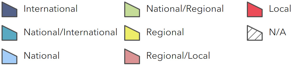
Main Beneficiaries Map
View Main Beneficiaries Map full screen in a new tab View Interactive Map HelpEcosystem service analysis
The following sections show the analysis used to determine key Ecosystem Service opportunities within the area. These opportunities have been combined with the analysis of landscape opportunities to create Statements of Environmental Opportunity. Please note that the following analysis is based upon available data and current understanding of ecosystem services. It does not represent a comprehensive local assessment. Quality and quantity of data for each service is variable locally and many of the services listed are not yet fully researched or understood. Therefore analysis and opportunities may change upon publication of further evidence and better understanding of the inter-relationship between services at a local level.
Note that numbers and figures in the body of the text are based on the 2014 profiles, unless otherwise stated.
Provisioning Services
Food provision
Assets/attributes: main contributors to service –
- Fertile soils
- Mixed agriculture with meat production, dairy and arable
- Orchards
State – The soils are fertile and versatile. 23 percent and 60 percent of soils are classified as Grade 2 or 3 soils respectively. 52 percent of the area is pasture or uncropped land. This supports dairying, sheep and cattle grazing, the largest agricultural interest in the area. This is followed by cereals which cover 25 percent of the area.
Miscanthus growing is increasing in the area, mainly used for animal bedding. Cider apple orchards are a notable feature, especially in the southern half of the area.
Main beneficiary – Regional
Analysis – The mild climate, good growing conditions and fertile soils mean this is an area long associated with food production evidenced by the numbers of manors dating from the 16th century built on the back of the wealth generated by farming.
Traditionally the area has been one of mixed farming, the lowlands associated with cereals and the Quantock and Exmoor fringes associated with animal grazing. Between 2000 and 2009 there has been a reduction in permanent grasslands, sheep and dairy cattle, loss of orchards, and increase in vegetable growing and miscanthus. Although there has been an overall reduction in livestock, particularly in sheep, there has been a shift from dairy to lowland cattle and meat production.
The area remains highly productive and trends suggest a shift in farming patterns in response to economic drivers, and potential intensification in some areas, for example more intensive grazing of rough pastures. Maintaining landscape setting and ensuring appropriate and beneficial soil and nutrient management, avoiding sedimentation and minimising diffuse pollution, will be essential both for the maintenance of food production levels and other services, notably soil quality, water quality, biodiversity and buried archaeology.
Orchards, primarily for cider production, used to be a feature of this area, most notably in the south. There has been a trend of orchard removal. In 2000, 388 ha of orchard remained and in 2009, 326 ha. Some replanting is occurring but this tends to be bush orchards which have a different character.
Opportunities – Work with farmers and land managers to maintain a balance between profitability and the long-term viability of food production levels, miscanthus growing and the protection and enhancement of the natural and historic environment and sense of place.
Support and advise livestock farmers on integrating extensive beef and lamb production with management of the semi-natural grasslands within the NCA.
Work with the farming community to ensure good soil and nutrient management, thereby securing a sustainable future for farming, protecting environmental features within the area, and supporting the supply of other ecosystem services.
Encourage management of traditional orchards and sympathetic management of new orchards to maximise their benefits for biodiversity and their contribution to sense of place and culture.
Develop links between local food producers and local tourism, hotels, pubs and schools. Highlight links between food production and the valued landscape.
Principal services offered by opportunities –
- Food provision
- Regulating soil quality
- Regulating soil erosion
- Regulating water quality
- Sense of place/inspiration
- Sense of history
- Biodiversity
Timber provision
Assets/attributes: main contributors to service –
- Scattered patches of broadleaved woodland
- In field, hedgerow and riverside trees
State – There are approximately 2,799 ha of woodland in the area which equates to 6 percent coverage of the total area.
Approximately 626 ha is ancient woodland.
Broadleaved woodland accounts for 1,383 ha and 502 ha are conifer.
Tree species include black poplar and willow, and in field trees such as oak are also present.
Main beneficiary – Local
Analysis – Timber production is of limited interest in this NCA. Tree cover is generally afforded by hedgerow and riverside trees. Small woodlands are found on slightly higher ground, and at the fringes of the NCA woodland particularly to the south. Woodlands were managed for timber for farm use and pheasant shooting.
High agricultural productivity, low woodland cover and a predominance of black poplar, willows and alder with some oak and ash mean timber quality is likely to be negligible, except for small local usage.
Small amounts of timber could possibly be obtained for bespoke items and local use from infield, hedgerow and riverside trees, although this is likely to be of a small scale.
There is some scope for planting to improve timber levels and woodland coverage, but this should be within landscape character and species should reflect current local patterns. Forestry Commission calculations indicate there is potential to for a further 1,500 ha of woodland approximately.
Opportunities – There is little opportunity for timber provision from this area.
Seek opportunities for small-scale expansion of local woodland in appropriate locations, to support increased biodiversity, reinforce landscape character around the fringes of the area, reduce rates of water flow and sedimentation from adjacent hills and potentially provide a local source of timber.
Principal services offered by opportunities –
- Timber provision
- Sense of place/inspiration
- Regulating water flow
- Regulating soil erosion
- Biodiversity
Water availability
Assets/attributes: main contributors to service –
- Main rivers flowing through area transporting water from surrounding uplands
- Bridgwater and Taunton Canal
- Hawkridge and Durleigh Reservoirs
State – The main rivers in the area are the Tone, Doniford Stream and its tributaries arising in the Quantocks and Brendon Hills; and many streams that drain off the Quantock dip-slopes and flow across the area into the River Parrett (just outside of the NCA in the Somerset Levels and Moors). In the north of the NCA there are several small coastal rivers such as the Pill River, the Kilve Stream and the River Aller.
The underlying geology of mudstone and sandstone is important locally for private and small-scale groundwater supplies and for producing springs to feed streams. To the south-west, the Quantock Hills and Upper Tone Valley are underlain by older rocks that are also strongly folded and faulted slates and shales and are classed as Minor Aquifer Units.
The NCA includes two major reservoirs at Hawkridge close to the eastern edge of the Quantocks supplying Bridgwater and Durleigh close to Bridgwater (now primarily managed for recreation and wildlife and water supply to Bridgwater).
The main abstractions in this NCA are for amenity use, fish farms, production of energy, industry and public water supply.
Main beneficiary – Regional
Analysis – The southern part of the NCA is classed as ‘over licensed’ for groundwater and surface water therefore has no further water available for abstraction; the north west mainly has ‘water available’ in relation to surface water while in the north east there is a small area of surface water that is ‘over abstracted’.
Other than the main settlements in the south of this NCA, Taunton and Wellington, this is a rural area with few urban areas and minimal demand on water resources. The proposed expansion of Taunton, Wellington and Bridgwater on the outskirts of the NCA may see an additional increase in demand for public water supply.
Changes in farming patterns and an increase in miscanthus may place an additional demand on water availability and consideration needs to be given to siting of miscanthus and water conservation methods.
Bridgwater and Taunton Canal, which supplies drinking water to Bridgwater, and reservoirs at Hawkridge and the numerous natural springs and flood plain and coastal grazing marsh associated with some of the rivers, are important wet habitats supporting a range of species, including the black poplar which prefers damp conditions.
Increasing drought conditions may be of concern in the future which may affect water availability, especially rivers in the south which flow into the Somerset Levels and Moors and care will be needed to ensure water remains available to support this adjoining NCA.
Opportunities – Seek opportunities to further increase areas of semi-natural habitats, especially flood plain grazing marsh to improve water infiltration and targeted water storage.
Promote water conservation initiatives to farmers and in new developments to ensure these have a limited impact on water availability.
Ensure careful siting of miscanthus to prevent undue impact on water availability.
Identify and support initiatives that further knowledge and understanding of the environmental and economic impacts of drought and the relationship to other ecosystem services.
Principal services offered by opportunities –
- Water availability
- Food provision
- Regulating water flow
- Regulating water quality
- Regulating soil quality
- Sense of place/inspiration
- Sense of history
- Biodiversity
- Climate regulation
Genetic diversity
Assets/attributes: main contributors to service –
- Local varieties of apple many associated specifically with the area
- Cider orchards
State – Many villages and farmsteads retain small traditional orchards preserving a number of locally important apple varieties, particularly local cider varieties. New bush orchards have also been planted.
Main beneficiary – Regional
Analysis – Although often severely decayed and containing only senescent trees, numerous farm orchards are found throughout the area. Cider varieties are of particular note and have a longstanding association with the area and varieties such as Dunnings Russet, Even Pearmain and Fairmaid of Taunton are recorded from this locality. Traditionally, agricultural workers in the area received part of their wages in cider.
It is important to maintain the genetic diversity of orchard fruit varieties in order to safeguard future food and drink provision, retain local distinctiveness and culture and afford increased resilience to climate change and disease.
New orchards have been planted in response to upsurge of interest in local cider. Many of these, however, are bush orchards which have a different character and often utilise more commonly found apple varieties. It is important now to plant older variety apples in more traditional orchards as part of local heritage and protection of the genetic resource.
Opportunities – Encourage regeneration of existing orchards and new planting with local varieties.
Raise awareness of local apple varieties and link owners of orchards with local fruit and cider producers and suppliers.
Principal services offered by opportunities –
- Genetic diversity
- Biodiversity
- Sense of place/inspiration
- Sense of history
- Food production
Biomass energy
Assets/attributes: main contributors to service –
- Fertile soils
- Woodland
- Dense hedgerow network
- Field and hedgerow trees
- Miscanthus
- Orchards
State – Good growing conditions and fertile versatile soils mean that short rotation coppice and miscanthus could be grown in this area. Miscanthus is already established in some parts of the NCA; however, this tends to be utilised for animal bedding.
The existing woodland cover and the large number of hedgerow trees and dense hedgerow network offers potential for small-scale biomass production.
Main beneficiary – Local
Analysis – Defra yield maps indicate that the majority of the NCA has the potential for a medium yield of short rotation coppice and a high yield of miscanthus. The lack of nearby facility to utilise this material means however that this is currently a limited opportunity.
Short rotation coppice may be accommodated within low lying enclosed landscapes where possible linked with willow clumps and within existing field patterns. Miscanthus is more suited to mixed farmland within the existing pattern of arable cropping and an enclosed landscape. Biodiversity, agricultural productivity and archaeological interests alongside soil and water quality may limit opportunity.
The existing woodland cover (6 percent of the NCA) offers limited potential for the production of biomass by bringing existing woodlands under management or as a by-product of commercial timber production. Small-scale woodland management for timber for use and pheasant shooting may yield some supply. Similarly hedgerow and orchard management may also bring small-scale biomass production potential.
Opportunities – Work with the farming community to identify suitable locations for the increase in net yield of miscanthus and short rotation coppice, avoiding locations that would be contrary to local landscape character, likely to impact on archaeological deposits or be in conflict with nature conservation opportunities.
Explore initiatives that make use of arisings from the management of woodland, orchards and hedgerows, as sources of biomass and biofuel.
Principal services offered by opportunities –
- Biomass energy
- Climate regulation
- Water availability
- Regulating water flow
- Biodiversity
Regulating Services
Climate regulation
Assets/attributes: main contributors to service –
- Mudflats along coastal fringe
- Woodland
- Areas of coastal flood plain grazing marsh
- Soils under pasture
State – Carbon storage in the soils is low, ranging from 0-5 percent with occasional areas reaching 10 percent in the south. There may also be pockets of higher carbon content in soils underlying remaining areas of coastal and flood plain grazing marsh and
in the soils of woodlands and pasture.
Main beneficiary – Local
Analysis – This NCA has a relatively low carbon storage potential as soils tend to be loamy clayey which do not have high carbon storage capacity. However, those underlying woodland, coastal and flood plain grazing marsh, mudflats and permanent pasture may have increased capacity and an ongoing sequestration role. This can be enhanced by increasing organic matter content, where appropriate and if conditions allow.
Some of the regularly tilled soils are principally mineral soils and have little or no organic material within them. Hedgerows and hedgerow trees will be good at capturing and storing carbon.
Opportunities – Carbon sequestration can be increased in soils by increasing organic matter inputs and/or by reducing the frequency or area of cultivation.
Explore potential for local woodfuel production, as a carbon neutral fuel and has a low carbon footprint in terms of harvest and transportation to end user. Consider potential to produce material through management of existing hedgerows, woodland and trees and through the appropriate planting of new hedgerows and woodland and trees.
Retain permanent pasture and consider restoration of permanent pasture and introduce or maintain sustainable grazing levels to reduce soil poaching and disturbance which will help carbon storage capacity of soils.
Principal services offered by opportunities –
- Climate regulation
- Food provision
- Water availability
- Regulating soil quality
- Regulating soil erosion
- Regulating water quality
- Regulating water flow
- Sense of place/inspiration
- Sense of history
- Biodiversity
Regulating coastal erosion and flooding
Assets/attributes: main contributors to service –
- Natural and dynamic cliff systems
- Intertidal sand and mudflats
- Limestone shelves
- Beaches
- Maritime cliff and slope
State – The coastline runs from Hinkley Point in the east to Minehead in the west, with the majority designated as SSSI, made up of the Blue Anchor to Lilstock geological SSSI and, to the east, the Bridgwater SSSI.
The Blue Anchor to Lilstock SSSI provides an example of a series of cliff sections through the uppermost Triassic rocks of the Penarth Group down to the lowermost part of the Jurassic (205-142 million years ago) Lias Group.
By contrast, the Bridgwater SSSI comprises a low-lying coastline with a succession of habitats with extensive intertidal mudflats, salt marsh, shingle beach and grazing marsh intersected by a complex network of freshwater and brackish ditches and supporting internationally and nationally important numbers of over-wintering and passage migrant waders and waterfowl.
Most of the coastline is undefended (The North Devon and Somerset Shoreline Management Plan, Environment Agency, 2010 & Severn Estuary Shoreline Management Plan, Environment Agency, 2000), although several sections have groynes and seawalls. The beach at Minehead was recharged in 1998: it is more or less stable with a slight tendency to erosion. The policy for this stretch of coast as set out in the Shoreline Management Plan 2 is to ‘hold the line’ until it is no longer economically and technically sustainable, and then to move to managed realignment.
There are areas of coastal and flood plain grazing marsh, maritime cliff and slope, intertidal sand and mudflats, fen, marsh habitats, vegetated shingle, coastal salt marsh which support this service.
Daw’s Castle at Watchet, which is a scheduled monument, is at high risk from coastal erosion. Other coastal or tidal archaeology to be noted includes the number of fish traps along the coast.
Main beneficiary – Regional
Analysis – The coastline is of mixed geology with both cliffed and low-lying areas. It is a dynamic coastline; the low lying cliffs are alternating layers of soft and harder geology with different erosion rates. Platforms of limestone can be found on beaches, especially in the Kilve area as a result. Because this section of coastline has nationally important geological features, including its dynamic geomorphology, improvements to coastal defences may pose a threat to these features.
In the area of Bridgwater SSSI the coastline fronts a low lying area susceptible to flooding, which will be exacerbated by sea level rise and with this, there is likely to be a narrowing of the inter-tidal zone, increasing the amount of energy reaching sea defences. Stolford, on the edge of the NCA, is threatened by flooding of homes, businesses and roads if the coast realigns and there are power lines running from Hinkley Point across this flood plain also in danger. Some areas of the coast are protected such as Hinkley Point power stations (protected by a sea wall and rock armour) but again the area is susceptible to sea level rise. The area of Bridgwater SSSI is also designated as an SAC, SPA and Ramsar site requiring considerable care when considering alternative flood alleviation measures. Extensive areas of mudflat and beaches do however also provide some level of protection where these are found.
Much of the coast is a popular tourist destination, the beaches widely used for leisure and recreation and inland areas occupied by caravan and holiday facilities. This increases the pressure on maintaining coastal defences and beaches. The Marine and Coastal Access Act 2009 make recommendations for extending the England Coast Path between Brean Down and Minehead. Proposals put forward in 2013 make provision for rollback of land to retain this access.
Opportunities – Intervene as little as possible in the natural coastal processes which dominate the coast of this NCA.
Avoid construction of new structures and infrastructure that would, in time, require coastal defences and implement new approaches to secure these features, and in particular caravan parks and other features.
Investigate new approaches to securing coastal assets rather than attempt to defend the receding cliff, including considering more appropriate siting of development, habitat restoration along cliff edges and roll back land.
Seek to implement findings of Shoreline Management Plans.
Ensure coastal access opportunities remain while adapting to a dynamic coastline through the provision of roll back land and information and advice to users.
Ensure historic assets are recorded and factored into any coastal works.
Principal services offered by opportunities –
- Regulating coastal erosion and flooding
- Geodiversity
- Biodiversity
- Sense of place/inspiration
- Sense of history
- Recreation
Regulating water quality
Assets/attributes: main contributors to service –
- Rivers
- Bridgwater and Taunton Canal
- Hawkridge and Durleigh Reservoirs
- Flood plain and coastal grazing marsh
- Riparian habitats
- Land management within the catchment
State – For information regarding the current state of water quality within this NCA, refer to the Environment Agency (Draft river basin management plan maps).
Main beneficiary – National
Analysis – Substantial problems with water quality have been identified in this catchment from soil erosion and run-off leading to increased nutrient loading and subsequent enrichment of water courses. Evidence suggests that there are a number of potential sources including, intensive dairy, outdoor pig, poultry and maize production as well as diffuse agricultural pollution. The area around Taunton and the Rivers Tone and Parrett are of particular concern as they then flow into the Somerset Levels and Moors, an internationally important wetland for birds and ditch flora and fauna.
Other threats to water quality include; sedimentation as a result of erosion and damage to the soils both in and outside of the area; diffuse water pollution from agriculture, particularly run-off of manure, fertiliser, poor stock management infrastructure and chemicals; soil erosion due to overgrazing and excessive stock access to watercourses resulting in severe bank side erosion.
Measures to reduce soil erosion, sedimentation and nutrient loading from crop and livestock management are essential.
Ensuring continued efforts to maintain beach water quality through investment by water companies in sewage treatment plants and infrastructure and land management-based initiatives such as those which seek to reduce soil erosion, slow down and store water during high rainfall, increase water quality and enhance biodiversity remain key to maintaining good water quality entering the Severn Estuary SPA and SAC.
Opportunities – Work with farmers and landowners to establish and maintain best practice in water quality management including; sustainable grazing regimes and stocking rates; applications of organic matter and fertilizer; maintenance of farm infrastructure; and cultivation and cropping activity.
Work with farmers and landowners to identify crops and cropping regimes which require lower applications of fertiliser and pesticide, to help protect watercourses from chemical run-off.
Promote the use of buffer strips to watercourses, and the creation of riparian semi-natural habitat, supported through agri-environment schemes; manage livestock near water to prevent access to and erosion of bank sides.
Promote improvements in farm infrastructure and waste management.
Encourage positive management of vegetation along rivers, stream and canal that maintains water flow while helping to trap sediments and nutrients; manage and continue to introduce pastures, wet woodland and other wetland habitats in the flood plain, that help to filter water.
Seek opportunities to maintain beach water quality through investment by water companies in sewage treatment plants and infrastructure and land management-based initiatives such as those which seek to reduce soil erosion, slow down and store water during high rainfall, increase water quality and enhance biodiversity.
Principal services offered by opportunities –
- Regulating water quality
- Regulating soil quality
- Regulating soil erosion
- Regulating water flow
- Climate regulation
- Biodiversity
- Sense of place/inspiration
- Sense of history
Regulating water flow
Assets/attributes: main contributors to service –
- Rivers, streams and ditches
- Flood plain and coastal grazing marsh
- Bridgwater and Taunton Canal
- Hawkridge and Durleigh Reservoirs
- Pasture and grassland habitats
- Geology
State – There is little risk of flooding across most of the area. However Taunton and Bridgwater on the fringes of this NCA are susceptible, affected by flooding events associated with the River Tone and the River Parrett respectively. The main Parrett does not flow through the NCA itself, but its north-west tributaries do. Flooding here has been limited to local surface water problems.
Coastal rivers in the north of this NCA transport a significant amount of shingle which, when deposited upstream of culverts, can reduce their capacity and increase the likelihood of flooding. Shingle traps are currently emptied on a regular basis. Tidal flooding can be an issue at Minehead.
Main beneficiary – Regional
Analysis – Recent flooding in the Tone and its tributaries has been strongly driven by local surface water problems, exacerbated by some farming practices which have increased field run-off locally. A flood protection scheme is in place for Taunton (Project Taunton). This scheme protects Firepool and other proposed development areas although any future development in both settlements will require flood risk management proposals.
Streams in the west are typically steep and fast-flowing, draining from the highlands of Exmoor and the Brendon and Quantock Hills and flowing northwards to the sea. Geology has a significant influence on the response to rainfall. The geology of West Somerset has low permeability; this contributes to the high level of overland flow and the rapid response of the rivers to rainfall. These watercourses carry material with them that can then cause local problems with capacity. Measures are in place to regularly empty shingle traps. Measures to reduce the amount of material entering these rivers should be put in place, alongside maintaining river channels to reduce blockage.
Opportunities – Ensure any new development in and around Bridgwater and Taunton includes flood risk management proposals.
Implement measures outlined in the Shoreline Management Plan and the Catchment Flood Management Plan.
Seek opportunities to expand areas of wetland habitats (such as grazing marsh) and riverside habitats to help reduce sedimentation and flow into watercourses.
Work with farmers and landowners to establish and maintain best practice in soils management including; grazing regimes and stocking rates; applications of organic matter and fertilizer; and cultivation and cropping activity to help reduce sediment flow into watercourses.
Maintain river channels, especially debris clearance to reduce risk of blockage.
Principal services offered by opportunities –
- Regulating water flow
- Regulating water availability
- Regulating water quality
- Regulating soil erosion
- Biodiversity
Regulating soil quality
Assets/attributes: main contributors to service –
- Soil types
- Semi-natural habitats and permanent pasture
- Mixed farming
State – The complex geology of the area is reflected in the different soils types found throughout. The Triassic mudstones and sandstones around the edge of the low vale produce light, freely draining soils. Calcareous clay and stagnogley soils are more common over the mudstones and clays and soils are generally slightly acid loams and clays with impeded drainage.
There are five main soilscape types in this NCA:
- Slightly acid loamy and clayey soils with impeded drainage, covering 46 percent of the NCA.
- Freely draining slightly acid loamy soils (35 percent).
- Lime-rich loamy and clayey soils with impeded drainage (7 percent).
- Slowly permeable seasonally wet slightly acid but base-rich loamy and clayey soils (5 percent).
- Loamy and clayey flood plain soils with naturally high groundwater (4 percent).
Main beneficiary – Regional
Analysis – Those soil types covering more than 10 percent of the NCA are described below.
The slightly acid loamy and clayey soils with impeded drainage (46 percent) are easily poached by livestock and compacted by machinery when the soil is wet. Weak topsoil structures can easily be damaged, and careful timing of activities is required to reduce the likelihood of soil compaction.
The freely draining slightly acid loamy soils (35 percent) have potential for increased organic matter levels through management interventions. They may be valuable for aquifer recharge, requiring the maintenance of good structural conditions to aid water infiltration and requiring the matching of nutrients to needs to prevent pollution of the underlying aquifer.
The versatile soils of the area have long supported food production; the numerous manor houses and farmsteads throughout testify to the wealth generated by agriculture. The main types of loamy clayey soils are typically versatile and support a range of uses including arable cropping and horticulture.
There is a risk with climate change that drought conditions may increase which may mean a reduced capacity to support grass systems.
Opportunities – Work with farmers and landowners to establish and maintain best practice in soils management including; grazing regimes and stocking rates; applications of organic matter and fertilizer; and cultivation and cropping activity.
Encourage restoration of and an expansion in the area of permanent pasture.
Seek and realise opportunities to improve farm infrastructure, particularly the location of feeders and drinkers, and the use of droves and farm tracks, to minimise localised compaction and, or poaching. Minimise machinery/vehicle movements on vulnerable wet soils.
Improve levels of organic matter in soils where appropriate through the use of green manure crops such as legumes to help fix nitrogen and improve soil structure.
Principal services offered by opportunities –
- Regulating soil quality
- Regulating soil erosion
- Regulating water quality
- Regulating coastal erosion
- Food provision
- Water availability
- Biodiversity
Regulating soil erosion
Assets/attributes: main contributors to service –
- Soil types
- Semi-natural habitats and permanent pasture
- Mixed farming
State – Vulnerable loamy clay soils make this area susceptible to soil erosion; however the main effects of this are felt in the neighbouring Somerset Levels and Moors NCA. The Upper Tone and tributaries of the Upper Parrett that run through this NCA form part of the Somerset Levels and Moors priority catchment (Defra priority catchments identified under the England Catchment Sensitive Farming Delivery Initiative).
The Triassic mudstones and sandstones around the edge of the low vale produce light, freely draining soils. Calcareous clay and stagnogley soils are more common over the mudstones and clays.
Main beneficiary – National
Analysis – The vast majority of soils covering the NCA (88 percent) are at risk of erosion. Many of the slightly acid loamy and clayey soils with impeded drainage (46 percent) are prone to capping/ slaking, leading to increased risk of erosion. These and the lime rich loamy and clayey soils with impeded drainage (7 percent) are easily compacted by machinery or livestock if accessed when wet, increasing the risks of soil erosion by surface water run-off, especially on steeper slopes. Soils need to be managed carefully to reduce risks with careful timing of cultivations and maintenance of vegetation cover.
The freely draining slightly acid loamy soils (35 percent) have enhanced risk of soil erosion on moderately or steeply sloping land where cultivated or bare soil is exposed, often exacerbated where organic matter levels are low after continuous arable cultivation or where soils are compacted. There is also potential for wind erosion on coarse textured variants.
The slowly permeable seasonally wet slightly acid but base- rich loamy and clayey soils (5 percent) and the loamy and clayey flood plain soils with naturally high groundwater (4 percent) have a low erosion risk.
The Upper Tone and tributaries of the Upper Parrett that run through this NCA form part of the Somerset Levels and Moors Priority Catchment and have problems of soil erosion associated with vulnerable soils on steep slopes in areas of high rainfall. This is exacerbated by compacted soils associated with intensive dairy production, bare soils associated with outdoor pig farming, and areas of open grown crops (maize, potatoes and miscanthus) which are highly susceptible to soil erosion. In turn, this eroded soil erosion is leading to the eutrophication of the wetlands of the Somerset Levels and Moors SPA, with the River Tone feeding Curry and Hay Moors SSSI which are in unfavourable condition.
Opportunities – Work with farmers and land managers to apply the principles of good soil management as advocated by initiatives such as Catchment Sensitive Farming.
Where opportunities arise and in particular alongside rivers, reinstate permanent pasture and introduce grassland margins to arable fields to help reduce soil erosion.
Encourage the use of green manure crops, such as nitrogen- fixing legumes, within arable systems to replace nutrients and bind soil, winter stubble options in agri-environment agreements, and limiting livestock access to watercourses in locations particularly prone to erosion, for example along the River Tone and its tributaries.
Principal services offered by opportunities –
- Regulating soil erosion
- Regulating soil quality
- Regulating water quality
- Biodiversity
Pollination
Assets/attributes: main contributors to service –
- Pastoral landscape with semi-natural grassland
- Dense hedgerow network
- Orchards
- Vegetable growing
State – The NCA has small areas of semi-natural grassland that can provide some sources of nectar for pollinating insects but the main sources are likely to be the dense pattern of hedgerows with their flower-rich hedgebanks and the large number of remnant traditional orchards.
Main beneficiary – Local
Analysis – This NCA provides a significant and well distributed source of nectar for pollinating insects. However, much of the remaining semi- natural grassland, while floristically quite diverse and still displaying many flowering plants, remains vulnerable to improvement, removal and under grazing with a subsequent risk of losing floristic diversity. These meadows in conjunction with the soft cliffs at the coast are likely to provide habitat for solitary mining bees and other invertebrates.
The current extent of pollinator friendly habitats in the NCA is relatively high and in particular the dense network of flower-rich hedgerows and scattered orchards provide the largest, if seasonal source of nectar. Intensive management of these features would reduce their benefit to pollinators.
Management regimes to achieve a favourable habitat condition would, in turn, promote greater densities of pollinating species. In particular sympathetic hedgerow management would maximise the benefits of this network.
Opportunities – Bring areas of semi-natural grassland into suitable grazing management, including areas of under grazed coastal grassland.
Sympathetically manage hedgerows and orchards to encourage floristic diversity and to enhance the habitat network for pollinators.
Seek opportunities to enhance the habitat network for pollinators and increase nectar provision in the farmed landscape by restoring and creating lowland meadows; planting field margins using floristically diverse species mixes where appropriate; enhancing road verge floristic diversity through management and planting; and taking advantage of new development to create habitat for pollinators.
Ensure management of soft rock exposures does not destroy mining bee and other invertebrate habitat opportunities.
Principal services offered by opportunities –
- Pollination
- Food production
- Biodiversity
- Sense of place/inspiration
- Pest regulation
Pest regulation
Assets/attributes: main contributors to service –
- Well-distributed semi-natural habitats providing habitat for pest predators
- Woodland
- Mixed farming
State – Pest regulation is currently supported by the existing spread of semi-natural habitat across the NCA. They provide habitat for natural predators which assist in controlling pest species, although there is little information on the exact contribution they make in this NCA.
Main beneficiary – Local
Analysis – The various habitats across the areas will support some level of natural predators of possible benefit to the areas orchards, vegetable growing and other cropping. Natural predators such as lesser horseshoe bats also rely on adequate sources of prey species to maintain viable populations. Measures to reconnect habitat linkages and improve habitat condition and extent will benefit this service.
Opportunities – Seek opportunities to enhance existing and create new semi-natural habitats to benefit natural predators.
Attempt to realise the full potential of the NCA’s farmed landscape for the suite of species that should be flourishing there through measures such as beetle banks.
Principal services offered by opportunities –
- Pest regulation
- Biodiversity
- Sense of place/inspiration
- Food production
- Pollination
Cultural Services
Sense of place/inspiration
Assets/attributes: main contributors to service –
- Wide expanse of coast and Bridgwater Bay
- Rich pastoral landscape fringed by hills
- Long views from the coast and more intimate settings across the rest of the NCA
- Well-wooded feel and tree- fringed rivers
- Rich physical and cultural heritage
- Local vernacular architecture and dispersed settlement pattern
State – The rich, gently rolling agricultural landscape of irregular fields enclosed by thick hedgerows, often on ancient hedge banks, with many narrow intersecting valleys and views to the surrounding hills of Exmoor and the Quantocks, and an open and windswept coast with low cliffs to the north, characterise this landscape and provide a sense of tranquillity and escapism although parts of the coastline can feel remote and rather bleak at times.
The area has a well wooded feel due to the extent of trees in hedges and scattered small woodlands, with large numbers of rare native black poplar found along the River Tone and its tributaries, while cider apple orchards are a characteristic but declining feature throughout the NCA.
A dispersed settlement pattern of hamlets and farmsteads linked by narrow winding lanes further defines the area, as does the diverse geology reflected in the local building materials of red sandstone, brown-grey Lias near the coast and occasional cob, and the mosaic of remnant semi-natural habitats ranging from wet woodland to calcareous and neutral grasslands.
The NCA (in combination with its surrounding landscape) has provided inspiration to poets and artists, most notably Coleridge who lived at Nether Stowey and wrote many of his most famous works here (including ‘Frost at Midnight’).
The adjoining features of Exmoor National Park (Quantock Hills Area of Outstanding Natural Beauty Blackdown Hills AONB contrast with this NCA, enhancing its lush pastoral nature and add to its sense of place and character.
Main beneficiary – Regional
Analysis – Pressure for change is most notable along the corridor of the M5 motorway and in places along the coast; for infrastructure and distribution, and tourism facilities respectively. Housing development around Taunton and Wellington and other larger settlements is also affecting a degree of change in the character of the area.
The pastoral character and wooded feel in contrast to surrounding uplands and an uncluttered windswept coast are the area’s most distinctive features. Changes in farming practice, removal of hedges and loss of orchards, pockets of meadows, parkland and hedgerow trees risk changing this character.
The landscape, and in particular its relationship with its surrounding uplands and the coast has and continues to provide inspiration for many people, the coast in particular providing a draw to visitors. The noteworthy geology at the coast, low lying cliffs and stark and generally uncluttered views across Bridgwater Bay are evocative and a draw to many visitors. Hinkley Point in the far north of the area punctuates the skyline adding a further dimension to this sometimes bleak coastline. Further development at this site and mitigation work will mean views will evolve and change over time.
Opportunities – Protect and enhance uncluttered and intimate views across and into this NCA and the distinctive features that characterise the area.
Land management practices, for example maintaining the balance of mixed farming, managing hedgerows with trees, in field trees, maintaining meadows, managing traditional orchards, should be sympathetic and enhance the biodiversity and rich cultural and geological heritage found here.
Opportunities exist to protect and restore hedgerows, trees, orchards, parkland and the vernacular architecture of settlements, manor houses and barns.
Ensure that development respects local settlement patterns and building materials, and avoid the loss of historical evidence through insensitive development.
Principal services offered by opportunities –
- Sense of place/inspiration
- Sense of history
- Tranquillity
- Biodiversity
Sense of history
Assets/attributes: main contributors to service –
- Hill forts and castles
- Field patterns and settlement patterns
- Geological record
- Strong surviving mixed agricultural landscape
- Manors and associated parkland such as Hestercombe and Nynhead
- Roman remains at Cannington
State – The history of the landscape is evident in iron-age, Roman, Saxon and medieval/post-medieval influence, including a predominantly irregular field pattern reflecting piecemeal enclosure of medieval strips, with prehistoric remains widespread and concentrations at the edges of the higher ground adjacent to Exmoor and the Quantocks.
Prominent features span the ages and act as a reminder of the wealth associated with the productive farmland of the area which has shaped and continued to shape the landscape; iron-age hill forts such as Cannington, the scatter of medieval motte and bailey castles beyond Taunton castle, and 18th-/19th-century mansions and parklands such as Hestercombe and Nynehead.
This sense of history is reinforced by the traditional buildings of local or imported stone and some thatched roofs, notably the sandstone churches that are a prominent feature of larger villages and typically feature a tall perpendicular tower, plus characteristic cider houses often incorporated within stabling.
Ridge and furrow still visible in fields giving a sense of long use of the farmed landscape.
The geological record and fossil finds at the coast provide an important record of past landscapes and environments. Coastal archaeology is present in the form of submerged forests, peat shelves, and medieval and later fish traps.
Recent research at Hinkley Point – a large-scale archaeological landscape investigation, comprising geophysical survey and excavation identified a variety of sites, including bronze-age occupation, iron-age and Romano British settlement and a rare Saxon settlement.
Main beneficiary – Regional
Analysis – It is the settlement patterns, and field patterns which reveal much of the story of this area as much as the remains of castles and manor houses. Long associated with versatile and fertile soils the area retains a strong sense of history associated with food production. The present pattern of settlement dates from late in the first millennium ad and is distinctive for its high density of dispersed farmsteads and hamlets. Many of these hamlets developed from small manorial centres. Later mansions and manor houses at the foot of Quantock Hills indicate an agriculturally prosperous area, which continues today. The erosion of field patterns, water meadows, ridge and furrow, loss of parkland and orchards and other landscape features such as hedgerows risk diluting this setting.
Maintaining the long-standing pastoral character of the area that contributes to the sense of history is dependent on sustainable livestock and farming regimes.
Inappropriately located development may also damage or result in the loss of both physical assets and the strong sense of history to be found.
Opportunities – Minimise disturbance and damage to archaeological sites resulting from cultivation through the use of methods such as shallow cultivation and in particular avoid changes to field patterns and removal of hedgerows. Protect features under permanent pasture where appropriate.
Work with landowners, farmers, local communities and local decision makers to safeguard heritage assets and the pervading sense of history, and identify and realise opportunities for the enhancement of the setting, interpretation and legibility of heritage assets.
Where opportunities for new development are proposed, use local vernacular architectural styles and settlement patterns to inform design solution that reinforce the existing sense of history. The restoration and conversion of vernacular buildings should be sympathetic, use local materials and preserve local distinctiveness.
Seek opportunities to re-plant and restore orchards and parkland to re-enforce landscape and historic setting.
Seek to continue and enhance interpretation of the many layers of historic evidence for educational and recreational purposes.
Maintain the built elements of the historic environment and where necessary find sympathetic and innovative uses for redundant historic buildings. Seek to retain the connection between rural buildings, such as farmstead, barns, manor and gentry’ houses and their surrounding landscapes.
Principal services offered by opportunities –
- Sense of history
- Sense of place/inspiration
- Biodiversity
- Food provision
- Tranquillity
- Geodiversity
Tranquility
Assets/attributes: main contributors to service –
- Pastoral landscape with small settlements linked by sunken lanes
- Largely undeveloped coastline
State – According to CPRE intrusion mapping tranquillity has declined significantly in the past 50 years, with the area of ‘undisturbed’ land having decreased from 74 percent in the 1960s to 40 percent in 2007. However, substantial areas of the NCA have remained sparsely populated and uncluttered by modern infrastructure and retain a sense of quiet and tranquillity.
The majority of intrusion into perceived tranquillity occurs along the M5 motorway corridor, around Taunton and Wellington and in places, such as Minehead associated with tourism along the coast.
Main beneficiary – Regional
Analysis – Tranquillity is an important feature of the NCA, and is closely associated with Exmoor National Park, Blackdown Hills AONB and Quantocks AONB which adjoin this NCA and have views out across it to the sea. Increased development along the M5 and A358 corridor, around Taunton, Wellington and Bridgwater on the edge of the NCA, and to a degree along the coast has increased disturbance in some areas. However, much of the area remains relatively sparsely populated, with small sunken lanes connecting settlements nestled in hedgerow rich farmland, giving a sense of remoteness and tranquillity.
Construction of Hinkley Point on the north eastern coast and associated development will increase localised disturbance for a time, although mitigation work in the long term could bring significant benefits to enhancing features associated with tranquillity.
The coastline, notably between Blue Anchor and Kilve remains largely tranquil, closely associated with the seascape of the Bristol Channel.
Opportunities – Seek to conserve remaining areas of tranquillity, the open uncluttered views and skylines and the strong pastoral character and the views close association it has with Exmoor National Park and two AONBs.
Seek to conserve areas of tranquillity associated with the coast, Bridgwater Bay and the Bristol Channel reflecting the strength of maritime character.
Seek opportunities for enhanced screening and mitigation of features around transport corridors, major developments and urban expansion which mitigate impacts on tranquillity and strengthen landscape character, contributing to biodiversity and sense of place.
Where possible infrastructure features such as power lines should be sensitively incorporated into the landscape.
Principal services offered by opportunities –
- Tranquillity
- Sense of place/inspiration
- Sense of history
- Biodiversity
Recreation
Assets/attributes: main contributors to service –
- 900 km rights of way network including South West Coast Path
- Canal towpath
- National Cycle Network
- Small amount of open access land
- Hawridge and Durleigh Reservoir and Bridgwater to Taunton Canal
- Beaches and coast
- West Somerset Railway
State – The area supports a number of opportunities to experience nature and the landscape. A good path network exists with around 900 km of rights of way (at a density of 1.85 km per km2) including the South West Coastal Path, the Channel-to- Channel Walk, Ride UK, Celtic Way, Quantock Greenway, MacMillan Way West, and the National Cycle Network.
There are also 380 ha of open access land covering 0.78 percent of the NCA. Hawkridge and Durleigh Reservoirs provide additional recreational opportunities in the eastern half of the NCA, including coarse fishing, sailing and bird- watching, while Exmoor and the Quantock Hills are notable recreational resources adjoining the area.
Main beneficiary – Regional
Analysis – Recreation is an important feature of this NCA, although most opportunities to access the natural environment are focused on the coast, around larger settlements such as Taunton and on the periphery to Exmoor National Park and Quantocks AONB. Coastal habitats and geological features are particularly sensitive so care is needed to balance the economic and health benefits of the areas recreation opportunities with maintaining and enhancing biodiversity, geological and heritage features.
Coastal tourism and recreational activities are notable. There are proposals to extend coastal access along 90 km of the coastline between Minehead and Brean Down under the Marine and Coastal Access Act 2009. This will extend rights of access to the coastline of this area and the shoreline.
Other features such as the areas two reservoirs and the West Somerset Railway offer different experiences of the landscape. Access and recreational activities, particularly close to where people live, brings mental and physical health benefits. A network of trails linking quality natural spaces and other visitor destinations can also provide significant benefits in terms of income from local visitors and tourists.
Expansion of the areas local communities, especially Taunton and Wellington may bring additional pressures and on footpaths, tow path and riverside walks and new routes and opportunities should be sought to enhance this network.
Opportunities – Further opportunities for enhancements to the public rights of way network should be realised.
Improved access should incorporate enhanced interpretation, particularly of natural and heritage assets and features.
Extend awareness of access and recreational opportunities available across the area, and particularly beyond the coast and adjoining National Park and AONB where possible.
Identify and realise opportunities to create new circular routes or links to existing rights of way, particularly around Taunton and Wellington and along major rivers taking all reasonable steps to prevent the spread of non-native invasive species.
Principal services offered by opportunities –
- Recreation
- Sense of place/inspiration
- Sense of history
- Tranquillity
- Biodiversity
- Geodiversity
Biodiversity
Assets/attributes: main contributors to service –
- Coastal and intertidal habitats including large areas of intertidal sand and mudflats and maritime cliff and slope, coastal and flood plain grazing marsh.
- Mix of woodland types
- Rare or notable species
- A number of designated sites or parts of designated SAC, SPAs,
- Ramsar and SSSI and local sites including areas of limestone grassland, fen, orchards, and lowland meadow
State – 6 percent of the NCA is covered by priority habitats including coastal and flood plain grazing marsh, covering 1,500 ha and 550 ha of woodland (wet woodland, lowland mixed deciduous and upland oakwoods).
1 percent of the area is designated SSSI covering 600 ha and there are 2 SPAs, 5 SAC and 2 Ramsar sites that part fall within this NCA. There are also 244 Local sites in Vale of Taunton & Quantock Fringes covering 2,039 ha which; 4 percent of the NCA.
A number of priority species are also present including (but not exhaustively) black poplar, lesser horseshoe bat, otters, small blue and Duke of Burgundy butterfly.
The wave cut platforms between Hinkley Point and Watchet create a significant rock reef system inhabited by a wide range of marine invertebrate.
Main beneficiary – National
Analysis – Habitats in the area are scattered and fragmented, except at the coast where the coastal strip is largely intact. Habitats such as coastal and flood plain grazing marsh, lowland calcareous grassland and lowland meadows are found in pockets throughout. However agricultural intensification, especially along the banks of the River Tone, and a small change in farming patterns, such as a change from pastoral to growing miscanthus, means sites are under threat of becoming more fragmented and inappropriately managed. Initiatives, such as the River Tone Living Landscapes Project, are helping to address these pressures.
A number of species, for example overwintering birds at the coast, such as curlew, will benefit from large areas of pastoral land if managed sensitively. Rivers provide a corridor through the landscape for some species such as bats, black poplars and otters.
97 percent of SSSI are in favourable or unfavourable recovering condition. A number of SAC, SPAs and Ramsar sites extend into the area from surrounding areas including the Severn Estuary SPA; Somerset Levels and Moors SPA; Exmoor Heaths SAC; Exmoor & Quantock Oakwoods SAC; Holme Moor & Clean Moor SAC and Severn Estuary SAC.
Overwintering birds such as wigeon, teal, turnstone and curlew are a feature. The area plays a key role in providing a network of smaller habitats to support and connect these designated sites and work could be completed to enhance this network.
Hestercombe House SAC sit wholly within the NCA and has been designated for lesser horse bats, which will use the network of hedges and woodland in the area as feeding and foraging ground.
Associated with the manors of the area are a number of wood pasture and parkland sites. Orchards are also a notable feature in the southern half of the NCA. Ensuring these remain in good condition with succession planting will be key to maintenance of both these features.
At the coast mudflats and other intertidal habitats are a key feature however, ‘coastal squeeze’ on intertidal habitats may be exacerbated in some areas as a result of a need to ‘hold the line’ of coastal defences in some stretches near to Minehead and Blue Anchor.
Opportunities – Improve the quality and increase the area of all priority habitats, notably flood plain and coastal grazing marsh, lowland meadows, wood pasture, orchards and arable habitats and connecting watercourses, looking to better connect, buffer, improve and create habitat patches, resulting in more coherent and resilient ecological networks to improve habitat resilience and enable necessarily responsive species movement.
Continue to use evidence to build a landscape scale approach to habitat management and restoration and to prioritise action on the ground, benefitting the strong sense of a special place and strengthening landscape character. In particular use all tools available, such as habitat mapping, to target appropriate action.
Protect and enhance designated sites aiming to achieve favourable condition on all sites and linking them, where appropriate (and where there is no risk of increasing the range of non- native invasive species), to the wider habitat network to further enhance their influence, functionality and resilience to climate change and other threats.
Identify and realise opportunities to protect, restore and manage coastal habitats and manage them appropriately to increase their adaptability to climate change and rising sea levels.
Principal services offered by opportunities –
- Biodiversity
- Regulating coastal erosion and flooding
- Regulating water quality
- Regulating water flow
- Regulating soil quality
- Food provision
- Sense of place/inspiration
- Climate regulation
Geodiversity
Assets/attributes: main contributors to service –
- Somerset Jurassic Coast
- Diverse geology with superb coastal exposures
- Important palaeontological resources
- Local vernacular
- Educational assets for outstanding geological interest
- One geological SSSI and local sites
- Hetangian/Sinemurian Global Stratotype Section and Point
- Geomorphology
State – The geology of the area is quite varied with a wide range of soil types. In the extreme west and south-west the underlying geology is Permo-Triassic pebble bed conglomerates breccias and sandstones. Rocks of this age extend north and east around the Quantock Hills and Taunton but here they are mudstones and marls.
In the far north of the area forming most of the cliffs and the intertidal zone are rocks of the upper Triassic and the lower Jurassic. The sequence consists of grey shales, mudstones and limestones which contain many fossils including marine vertebrates and invertebrates. Also expose along the coast are Quaternary periglacial loams, sands and gravels. Alluvium deposits also occur alongside the River Tone and its tributaries.
There is an isolated outcrop of Carboniferous limestone at Cannington Park.
The Blue Anchor to Lilstock Coast SSSI is in favourable condition.
Although there are quarries operating in the area these are limited for supplying local construction stone.
Main beneficiary – International
Analysis – The coastal geology of the area is of international importance for its Jurassic sequence and outstanding fossil finds; known as the Somerset Jurassic Coast. It is part of the same geology sequence exposed at the Dorset and East Devon World Heritage Site. The best sequence can be found between East Quantoxhead and Kilve. One particular cliff section near East Quantoxhead has been identified as a World Reference Point within the geological time scale and marks an internationally agreed division between two parts of the Lower Lias succession. This exposure, fossils, sedimentology and coastal geomorphological processes mean this whole stretch of coastline is designated a SSSI.
In 1916 some of the shales at Kilve were discovered to be bitumous and oil rich. Although there was some extraction of oil, production did not continue for long. Remains of this activity can still be seen in the car park at Kilve.
Of particular importance to this area is access to, interpretation of and the study, understanding and functioning of coastal geomorphological processes, palaeontology and its internationally important geology.
Managing fossil collecting activity is required to ensure responsible collecting and safety; cliffs of this sequence are liable to erosion and slumping. Maintaining the dynamic nature of the coastline is also a key part of the coastal geomorphology.
Local vernacular uses sandstone, Grey Lias and slate. Mansions and churches were generally constructed from imported stone. An isolated inlier of Carboniferous Limestone is quarried at Cannington near Bridgwater.
Permo-Triassic deposits, essentially comprising sandstones, mudstones and conglomerates, are worked on a minor scale only. Sand is available from the Triassic Pebble Beds and Conglomerate at Whiteball near Wellington. The Budleigh Salterton Pebble Beds are a source of building stone which is being worked at Capton near Williton. Clay from the Mercia Mudstone Group has been used for brick making at Poole to the east of Wellington. In earlier times, gypsum was mined near Watchet.
Opportunities – Ensure the importance of this coast’s geology and geomorphology is presented to both visitors and local people using interpretation of the highest quality.
Maintain and where appropriate enhance levels of access to the geodiversity assets of the coast.
Seek opportunities to allow coastal processes to take place unimpeded and maintain the current levels of unmodified geomorphological processes.
Ensure new developments in the area reflect the vernacular in high quality builds using local stone (and other materials where appropriate) and styles.
Investigate the ways in which marine geodiversity could be presented and interpreted, particularly in relation to the abundant marine biodiversity.
Seek to maintain and develop links with local research institutions, schools and higher education providers to raise awareness of and use of the site for research and education.
Principal services offered by opportunities –
- Geodiversity
- Biodiversity
- Sense of place/inspiration
- Regulating coastal erosion and flooding
- Regulating soil erosion
- Regulating water flow
- Regulating soil quality
- Tranquillity
- Recreation