

National Character Area 108
Upper Thames Clay Vales - Analysis: Ecosystem Services
Analysis supporting Statements of Environmental Opportunity
The following analysis section focuses on a selection of the key provisioning, regulating and cultural ecosystem goods and services for this NCA. These are underpinned by supporting services such as photosynthesis, nutrient cycling, soil formation and evapo-transpiration. Supporting services perform an essential role in ensuring the availability of all ecosystem services.
Bodiversity and geodiversity are crucial in supporting the full range of ecosystem services provided by this landscape. Wildlife and geologically-rich landscapes are also of cultural value and are included in this section of the analysis. This analysis shows the projected impact of Statements of Environmental Opportunity on the value of nominated ecosystem services within this landscape.
Further analysis on landscape attributes and opportunities for this NCA is contained in the Analysis: Landscape Attributes & Opportunities section.
Natural Capital
Further information on Natural Capital within this NCA is contained in the Natural Capital and Key Ecosystem Services section.
The Upper Thames Clay Vales NCA provides a wide range of benefits to society. Each is derived from the attributes and processes (both natural and cultural features) within the area. These benefits are realised through the ‘ecosystem services’ that flow from the ‘ecosystem assets’ or ‘natural capital’ of a place.
Natural capital means ‘the elements of nature that directly or indirectly produce value to people, including ecosystems, species, freshwater, land, minerals, the air and oceans, as well as natural processes and functions’ (Natural Capital Committee, 2017).
Ecosystem Services Main Beneficiaries
The below map displays the main beneficiaries of each ecosystem service identified within this NCA and neighbouring NCAs. These range from being of international importance to local importance. Some services have not been assessed within all NCAs, and therefore in some NCAs are displayed as “N/A” (not applicable).
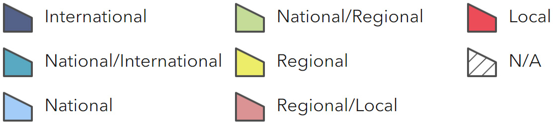
Main Beneficiaries Map
View Main Beneficiaries Map full screen in a new tab View Interactive Map HelpEcosystem service analysis
The following sections show the analysis used to determine key Ecosystem Service opportunities within the area. These opportunities have been combined with the analysis of landscape opportunities to create Statements of Environmental Opportunity. Please note that the following analysis is based upon available data and current understanding of ecosystem services. It does not represent a comprehensive local assessment. Quality and quantity of data for each service is variable locally and many of the services listed are not yet fully researched or understood. Therefore analysis and opportunities may change upon publication of further evidence and better understanding of the inter-relationship between services at a local level.
Note that numbers and figures in the body of the text are based on the 2014 profiles, unless otherwise stated.
Provisioning Services
Food provision
Assets/attributes: main contributors to service –
- Grade 1 and 2 agricultural land
- Orchards
- Livestock
State – A range of food is produced in this NCA. Grade 1 and 2 agricultural land is found over 16 percent of the NCA and allows for growing of cereals and, near Harwell for example, orchard fruit. Grade 3 land accounts for 45 percent and Grade 4 for 33 percent giving rise to considerable areas under grass managed largely for sheep. Dairy accounts for only 6 percent of farms.
Quaternary and alluvial deposits around the upper tributaries of the Thames, as for example in the west Oxfordshire district, and around the confluence of the Thame and Thames in south Oxfordshire make these areas fertile, freely draining and easily cultivated. Where these deposits are absent and consequently farming is directly on clay, agricultural land is not easily cultivated and is Grade 4. Grade 4 land is particularly concentrated in Aylesbury Vale and Cherwell districts.
Main beneficiary – Regional
Analysis – Some of the most productive soils are sandy brown-earths developed from the Greensand, which protrudes from beneath the Chalk scarp of the Chilterns. This is an important area for farming, contributing to employment, economy and maintenance of farmland habitats and landscape character.
Waterlogging and flooding of farmland is a significant impediment to farming in this NCA.
Agricultural activities and their sustainable management are closely linked to many of the cultural aspects of the area; the sense of place, biodiversity, sense of history and heritage assets.
Inappropriate agricultural activities can result in soil erosion and diffuse pollution, and reductions in soil quality and soil carbon storage. In some locations, well-managed production may have the capacity to increase outputs and given the close association between soil quality, water quality and stock rates and production.
Opportunities – Continue to work with the local farming community through environmental stewardship and other mechanisms to ensure sustainable production, avoiding adverse impacts on other ecosystem services such as soil and water quality.
Conserve soils and manage water storage in order to guard against widespread waterlogging and compaction. This will maintain productivity and also better regulate water flow.
Manage high-grade agricultural land under sustainable farming practices in order to maintain production in the long term and avoid negative impacts upon the environment.
Identify areas where reduced stocking rates or changed management techniques would positively influence water quality and reduce potential soil erosion along riverbanks, while maintaining viable levels of productivity.
Explore opportunities for arable reversion where this will increase the sustainability of food provision and secure benefits for regulating water flow and conserving soils.
Conserve traditional orchards in the interests of food provision, sense of place and nature conservation.
Principal services offered by opportunities –
- Food provision
- Regulating water flow
- Biodiversity
- Genetic diversity
- Regulating soil quality
- Regulating soil erosion
- Water availability
Timber provision
Assets/attributes: main contributors to service –
- Woodland
- Hedgerow trees
- Historic coppice
State – Woodland cover amounts to 3 percent or 6,300 ha of the NCA, although there is additional resource in the form of small woodlands or copses. Only 0.4 percent or 670 ha is coniferous plantation. Non- native poplar plantations are a feature in some parts of the NCA.
Hedgerow trees are a distinctive feature of Aylesbury Vale, for example, and so represent a potential timber resource.
Main beneficiary – Local
Analysis – Timber provision is limited by existing woodland cover and, in 2003, only 22 percent of woodland was managed under a woodland grant scheme. The timber resource is likely to be neglected as a minor land use. Remaining coppice stands are likely to be in poor condition.
Designation of the Great Western Community Forest across 14 percent of the NCA may stimulate tree planting in this area to boost timber provision.
Opportunities – There may be limited opportunities for woodland creation, helping to manage flows of water and limit soil erosion; however, their use for timber production will be limited. Sites supporting other semi-natural habitats, important species and heritage assets will need to be avoided.
Plant small woodlands as a connected network to realise opportunities relating to efficiency of forestry activities, to control of pests and diseases and to improve biodiversity.
Conserve trees of local provenance and encourage natural regeneration rather than planting in order to maximise resilience against pests and diseases. This will secure the timber resource and associated biodiversity and sense of place attributes.
Principal services offered by opportunities –
- Timber provision
- Biodiversity
- Pest regulation
Water availability
Assets/attributes: main contributors to service –
- Rivers and streams
- Chalk aquifers
- Aquifers based upon superficial deposits
- Reservoirs
State – There is a high density of watercourses and ditches and also reservoirs managed for public water supply, for example at Farmoor.
Across the clay, watercourses, ditches and associated wetland habitats are fed by surface water (Cherwell, Thame and Wye Catchment Abstraction Management Licencing Strategy, Environment Agency, 2012) and there is no baseflow supported by groundwater.
Principal aquifers associated with Chalk bedrock in the adjacent Chilterns and Berkshire Downs extend a little into this NCA. There are springlines along the base of the Chilterns and Berkshire Downs escarpments for example. The source of the NCA’s watercourses also originates from these aquifers and also the Cotswolds.
Secondary aquifers relating to deposits overlying the clays associated with watercourses are characteristic. Deposits are particularly widespread around the upper reaches of the Thames river system.
There are interconnections between the River Cherwell and the Oxford Canal (Cherwell, Thame and Wye Catchment Abstraction Management Licencing Strategy, Environment Agency, 2012). Water levels in these waterways are therefore interdependent.
Abstraction is predominantly for public water supply, with smaller volumes for agriculture. Surface water abstraction is dominated by supply to Farmoor Reservoir, which provides for Oxford, Banbury and Swindon in neighbouring NCAs (Thames Corridor Catchment Abstraction Management Strategy, Environment Agency, 2004). Farmoor Reservoir relies on the Cotswolds aquifer for 60 percent of its water. Water was also taken from the Thames for Didcot Power Station, but this has since closed. Elsewhere, abstraction is from groundwater.
Abstraction demands upon the Thames river system downstream of the NCA, including London, means that there is no water available for licensing at low flows in this NCA.
Main beneficiary – National
Analysis – Principal aquifers are largely absent, so groundwater is not stored within the NCA and rainwater flows out of it as surface water. Any type of reservoir, including the large reservoir at Farmoor, is important for storing water locally. Growth of settlements within the NCA such as Aylesbury and in adjacent NCAs such as Swindon will place new demands upon water availability.
The Thames Region is one of the driest regions in the UK. It receives an average of 690mm of rainfall each year compared to a national average of 897mm (Thames Corridor Catchment Abstraction Management Strategy, Environment Agency, 2004).
Public water supply demands across the wider Thames Region require that water use in the upper reaches takes account of supply needs downstream. Storage or transfers of water into this NCA have been considered by the water companies to secure adequate water supply locally and further downstream, including a proposal for a new reservoir near Abingdon.
Superficial deposits which function as secondary aquifers are also a focus of mineral extraction. Mineral operators have to manage against negative impacts upon hydrology.
Across the clay, rainfall has a direct and immediate impact upon surface waters, with ‘flash’ flooding possible.
Water availability is of significance to wetland habitats and species, including designated sites and legally protected species. Plant communities will alter where there is a change in water regime towards drier, wetter or more disturbed conditions. The Oxford Meadows SAC comprises grasslands that are seasonally flooded; a habitat which is very restricted nationally. Habitats are made more vulnerable by a history of drainage and their small size, for example, small fragments of fens.
Opportunities – Seek opportunities to store, hold and retain water for slower release and manage reservoirs and watercourses to allow sustainable water abstraction.
Encourage efficient water use and storage of water, for example farm reservoirs and water butts, among the general public and across the business sector within and beyond the NCA.
Work with land managers to promote good farming practices to improve the structure of soils, thereby improving infiltration of rainwater and reducing surface flow. For example, manage and create landscape features to slow flows of surface water, such as wet woodland and flood plain grassland. This guards against flash flooding, manages pollutants and enhances biodiversity.
Monitor and manage water levels in relation to water-dependent features, including Oxford Meadows SAC.
Principal services offered by opportunities –
- Water availability
- Regulating water flow
- Biodiversity
- Regulating water quality
Genetic diversity
Assets/attributes: main contributors to service –
- Oxford Sandy and Black pig
- Aylesbury duck
- Aylesbury prune
- Native black poplar
State – There are low numbers of the Oxford Sandy and Black pig in this NCA.
The area around Aylesbury has a history of duck rearing.
Aylesbury prune is included in the National Fruit collections at Brogdale.
Ancient oaks are found in Blenheim Park.
Native black poplars growing in Aylesbury Vale and the Cotswold Water Park Black are important for the genetic diversity and survival of this species.
Main beneficiary – Regional
Analysis – The Oxford Sandy and Black pig is one of the oldest British pig breeds in the country (RBST Fact Sheet: Oxford Sandy and Black, Rare Breed Survival Trust, 2012). The breed originated and developed in the Oxfordshire region.
It is likely that there are Aylesbury duck kept and bred in the NCA but the only commercial flock is located in the Chilterns, outside the NCA.
Local nurseries stock Aylesbury prune (a plum) and trees are found in remnant traditional orchards and hedgerows.
Some of the ancient, oak pollards of Blenheim Park may be direct lineal descendants of those recorded in the Domesday survey.
Work to conserve national populations of native black poplar centres upon the Aylesbury Vale.
Opportunities – Conserve traditional local breeds, including the Oxford Sandy and Black pig and Aylesbury duck for the benefit of genetic diversity, food provision and sense of place.
Conserve and restore traditional orchards and ancient hedgerows in order to secure local genetic material, particularly in relation to Aylesbury prune.
Seek biodiversity, sense of place, food provision and recreation benefits.
Conserve native black poplars for biodiversity and for sense of place.
Principal services offered by opportunities –
- Genetic diversity
- Food provision
- Sense of place/inspiration
- Biodiversity
Biomass energy
Assets/attributes: main contributors to service –
- Remnant coppice
- Existing woodland
State – This area has a woodland cover of 3 percent, meaning potential biomass from existing woodland sources is limited. Coppice is found in some woods, but is often neglected.
Main beneficiary – Local
Analysis – As a result of the varying underlying geology, potential miscanthus yield varies greatly across the area between medium and high. The potential yield for short rotation coppice is largely medium, but high in north-eastern areas between Oxford and Milton Keynes.
Planting short rotation coppice along watercourses and ditches may be feasible where this also contributes to managing floodwaters and enhances biodiversity. The restoration of gravel extraction areas may also allow for landscaping which accommodates short rotation coppice and miscanthus.
Planting short rotation coppice or miscanthus in those parts of the NCA where there are uninterrupted long views would alter sense of place. A long history of livestock farming and associated grassland management in many areas of the NCA makes planting of crops incongruous. Visual impacts from high ground in neighbouring NCAs should also be considered.
Opportunities – Explore opportunities to establish short rotation coppice in locations where it also manages floodwaters and enhances biodiversity, including mineral extraction areas, but does not impact negatively on sense of place or upon open habitats, including wet grassland supporting breeding waders.
Restore neglected coppice and introduce coppice management where this provides biomass and enhances biodiversity.
Principal services offered by opportunities –
- Biomass energy
- Regulating water flow
- Biodiversity
Regulating Services
Climate regulation
Assets/attributes: main contributors to service –
- Peat soils
- Long-term undisturbed/ uncultivated soils
- Wetland habitats
- Woodland
State – There are around 25 ha of peat in the NCA, comprising small areas of deep peat soils around Thame and a single area of deep peat near the River Evenlode.
Across almost all of the NCA there is a relatively low proportion of carbon stored in the top soil horizon (0-10 percent), with soil carbon content being generally slightly higher to the east of the NCA than to the west.
Soils that have not been cultivated, including areas of flood plain grassland, reedbed, fen and wet woodland, are long-standing carbon stores. There are approximately 7,200 ha flood plain grazing marsh, 1,700 ha wet woodland, 1,300 ha lowland meadow, 700 ha fen and 400 ha reedbed.
There are 6,300 ha of woodland or 3 percent cover. This low cover means that woodland carbon stores are limited.
Main beneficiary – Local
Analysis – The predominance of mineral soils limits carbon content, particularly where it is cultivated over the long term.
Storage capacity of soils is maximised where soils are undisturbed or uncultivated. Flood plain grasslands and other non-cultivated areas such as reedbed and wet woodland represent relatively intact carbon stores.
Drainage of wet soils, including peat soils and fen, leads to loss of carbon and a reduction in storage capacity. The change in land use can also lead to deterioration of carbon stores.
Woodland cover was higher in the past so woodland carbon stores have been lost.
Opportunities – Conserve areas of semi-natural wetland habitat, including flood plain grasslands, in order to maintain carbon stores, biodiversity and sense of place.
Maximise carbon content by conserving and boosting organic content in soils.
Protect peat soils and associated semi- natural habitat from damage.
Create new woodlands where it will increase carbon sequestration and storage capacity. Avoid new woodlands where it will impact negatively upon sense of place, valued views and
open habitats such as wet woodland supporting breeding waders.
Principal services offered by opportunities –
- Climate regulation
- Biodiversity
- Sense of place/inspiration
Regulating coastal erosion and flooding
No information available.
Regulating water quality
Assets/attributes: main contributors to service –
- Vegetated landcover, including grass strips and reedbed
- Low input grassland
- Semi-natural habitats including woodland, flood plain grazing marsh, and hedgerows
State – For information regarding the current state of water quality within this NCA, refer to the Environment Agency (Draft river basin management plan maps).
Main beneficiary – Regional
Analysis – With a clay-based geology, there is limited percolation of water into soils and so filtration of pollutants from surface water is also limited. Vegetation such as reedbed and wet woodland can trap pollutants in run-off. Bare cultivated areas and access tracks provide no filter. In particular, heavy rainfall will give rise to significant run-off. There is potential to greatly strengthen the ability of semi-natural habitats to filter run-off by linking or expanding existing fragmented habitat.
The entire NCA is a nitrate vulnerable zone. Water quality is regionally significant because the surface waters provide public water supply to major urban centres outside the NCA including Oxford, Swindon and downstream into London. Pollution of groundwater is a concern around Lechlade and along the southern border of the NCA in relation to principal aquifers of the Chilterns and Berkshire Downs. In the wider NCA, the nitrate vulnerable zone relates to surface waters.
In a nitrate vulnerable zone, land managers time their chemical applications carefully and avoid excessive use. Low input grasslands are beneficial to water quality in this NCA.
Despite features and land management practices to guard against water pollution, phosphates remain a problem. A large chlorinated solvents plume is also present in the groundwater body in the Vale of White Horse River Basin Management Plan – River Thames Basin District, Environment Agency, 2009).
There is also a bathing water beach at the Cotswold Water Park.
Opportunities – Implement catchment-wide water management plans to ensure a coordinated approach to reducing the impacts of pollution on water quality.
Maintain and create a network of features which slow and filter run-off, such as wet grassland, grass strips and reedbeds.
Create and manage buffer strips beside watercourses and ditches. This will regulate water quality and water flow, with consequent benefits for soils and biodiversity.
Encourage wider use of low input and efficient approaches relating to phosphate use such as precision farming. This will bring benefits for biodiversity.
Encourage adoption of sustainable land management practices to improve the soil structure through increasing organic matter, reducing compaction and promoting sustainable management to minimise the loss of sediments.
Principal services offered by opportunities –
- Regulating water quality
- Regulating water flow
- Regulating soil erosion
- Biodiversity
Regulating water flow
Assets/attributes: main contributors to service –
- Flood plain
- Ditches
- Locks and sluices
- Traditional flood meadows
- Monitoring stations
- Vegetated land cover
- Mineral extraction areas
State – Flood risk occurs along the course of the River Thames and its tributaries, and winter flooding is a regular event. Settlements in the flood plain and therefore at risk of flooding include Lechlade and Abingdon. Flood defences have been constructed to protect places such as Lechlade and Kidlington.
Watercourses have been modified across the NCA to regulate water flow. Water level management structures include locks, sluices and ditches. The few remaining traditional flood meadows retain historic water level management features. The Thames has a long history of monitoring stations. Surface run-off is slowed by features such as hedgerows, grass strips, woodland and reedbed. There are approximately 7,200 ha flood plain grazing marsh, 6,300 ha woodland, 1,300 ha lowland meadow, 700 ha fen and 400 ha reedbed.
Mineral workings offer opportunities to store and manage water.
Main beneficiary – National
Analysis – This is an area of low to medium flood risk. There is high potential for flooding from surface and river water but the density of settlement is low. Roads and railways are affected when adjacent ditches reach capacity. However, impact can be considerable as illustrated when widespread flooding occurred in 2007 and 2014 (Environment Agency, Thames Catchment Flood Management Plan – Summary Report, 2009).
The Thames Catchment Flood Management Plan proposes guarding against flood damage by storing water and managing run-off, rather than creating large-scale flood defences (Thames Catchment Flood Management Plan – Summary Report, Environment Agency, 2009).
Management of water flow in this NCA has implications downstream into London. This is significant as the River Thames corridor becomes more densely populated downstream, for example at Reading and Maidenhead.
In Aylesbury, urban growth has meant that many rivers are modified and straightened to improve their capacity to convey water. Aylesbury is also a focus for further development and there are properties at risk of flooding.
Features to slow run-off are important in this NCA where the clay-based geology facilitates rapid run-off. Management of run-off will be particularly important where it protects significant numbers of properties and key infrastructure including roads.
Restoring river channels, creating and managing riparian habitats as well as engineered schemes that store floodwater can provide long-term benefits for the regulation of water flow as well as river environment and wetland habitats.
Mineral workings modify local hydrology and can involve significant activities such as de-watering. Best practice guidance emphasises the importance of understanding and managing hydrological impacts. There are opportunities for storing water.
Opportunities – Encourage a catchment management approach through working with landowners, farmers, the Internal Drainage Boards, statutory agencies and conservation bodies to best manage the flow of water across the landscape. Ensuring floodwater is accommodated in areas where there is minimal impact on food production and maximum benefit for biodiversity is essential.
Review and realise flood-compatible land uses in the flood zone, seeking benefits for biodiversity and recreation where possible.
Maintain and create a network of semi- natural features which slow run-off. These features should also regulate water quality by filtering pollutants.
Conserve and restore historic flood meadows, locks and ditches so at water levels can be managed for the benefit of water flow, sense of history and biodiversity.
Continue to monitor water flow to understand change over time.
Manage mineral workings and restoration schemes to avoid negative impacts upon local hydrology. Seek to regulate water flow in a way which also provides wildlife habitat and safe recreation opportunities.
Principal services offered by opportunities –
- Regulating water flow
- Biodiversity
- Regulating water quality
- Sense of history
Regulating soil quality
Assets/attributes: main contributors to service –
- Grade 1 and 2 agricultural land
- Lime-rich soils
- Undisturbed soils, including established fen soils
- Permanent grassland
- Traditional flood meadows
State – There are nine main soilscape types in this NCA:
- There are nine main soilscape types in this NCA:
- Slowly permeable seasonally wet slightly acid but base-rich loamy and clayey soils, covering 45 percent of the NCA.
- Freely draining lime-rich loamy soils (16 percent).
- Loamy and clayey flood plain soils with naturally high groundwater (8 percent).
- Shallow lime-rich soils over limestone (8 percent).
- Loamy soils with naturally high groundwater (6 percent).
- Lime-rich loamy and clayey soils with impeded drainage (5 percent).
- Freely draining slightly acid but base-rich soils (5 percent).
- Freely draining slightly acid loamy soils (4 percent).
- Slightly acid loamy and clayey soils with impeded drainage (3 percent).
Grade 1 and 2 agricultural land is found over 16 percent of the NCA and allows for growing of cereals and, near Harwell for example, orchard fruit.
Grade 3 land accounts for 45 percent.
Main beneficiary – Local
Analysis – Soil damage associated with compaction is particularly relevant in this NCA since slowly permeable seasonally wet slightly acid but base-rich loamy and clayey soils cover approximately 45 percent and are prone to compaction and/ or capping when wet. Compaction also leads to increased run-off, leading to erosion and sediment transport. The freely draining lime-rich loamy soils (16 percent) are typically of moderate depth and droughty, but due to their calcareous nature they have a degree of natural resilience.
Drainage of fen has occurred in the past, leading to shrinkage of the resource. Drying of fen soils releases carbon and a change in land use may cause soil quality to deteriorate. Keeping some soils wet is important to retain their carbon content especially those with a high peat content in the river valleys.
Management that help to maintain a good soil structure such as increasing soil organic matter levels and the use of minimum tillage such as direct drilling will help improve soil quality, as well as reducing the potential for soil erosion in freely draining soils.
Much of the NCA is in agricultural use where maintaining and improving the soil quality will safeguard and retain productive food provision in the long term and increase the soils resilience to climatic change and extreme weather events. Retaining and increasing the amount of semi-natural habitat and tree cover in this NCA would help keep and improve soil condition. Well managed permanent grassland will also conserve soils where compaction is avoided.
Compared with other farming methods, traditional management of flood plain grassland and wetland habitats is low intensity and involves limited input of artificial chemicals – this supports natural soil processes. Such management continues on land designated the Oxford Meadows SAC which totals 276 ha.
Opportunities – Practice sustainable farming techniques so that soil quality is conserved while also maintaining food provision and other services.
Conserve permanent grassland and semi-natural habitat, including fen, in order to maintain soil quality and biodiversity and also guard against soil erosion and water pollution.
Maintain traditional management of historic grasslands in order to conserve soil quality, biodiversity and sense of history.
Promote cultivation with soils in mind – adopting Defra’s Code of Good Agricultural Practice (2009) and the Environment Agency’s Think Soils initiative (2008) to avoid compaction and maintain good soil structures.
Increase where possible the areas under woodland or permanent vegetation to stabilise the soil, increase quality with organic matter and soil fauna.
Principal services offered by opportunities –
- Regulating soil quality
- Food provision
- Regulating soil erosion
- Biodiversity
Regulating soil erosion
Assets/attributes: main contributors to service –
- Soils with high moisture content
- Semi-natural wetland habitat
- Well-managed pasture soils
- Woodland, hedgerows and areas of permanent pasture
State – Soils across approximately 60 percent of the NCA have a low risk of soil erosion. These soils are the slowly permeable seasonally wet slightly acid but base- rich loamy and clayey soils (45 percent), loamy and clayey flood plain soils with naturally high groundwater (8 percent) and loamy soils with naturally high groundwater (6 percent).
Undisturbed and vegetated soils associated with semi-natural habitats such as reedbed and wet woodland are associated with low erosion risk. Permanent grassland also retains a long-term protective vegetation cover reducing soil erosion as opposed to cultivate areas which have a higher risk.
The freely draining lime-rich loamy soils (16 percent), the shallow lime-rich soils over chalk or limestone (8 percent) and the freely draining slightly acid loamy soils (4 percent) are at risk of erosion only on sloping land where cultivated or bare soil is exposed (such as along footpaths and tracks or as a result of outdoor pig rearing in the case of the soils over chalk/ limestone).
Drainage is impeded across nearly 10 percent of the NCA, with these soils being susceptible to compaction. These are the slightly acid loamy and clayey soils with impeded drainage (3 percent) and the lime-rich loamy and clayey soils with impeded drainage (5 percent).
Main beneficiary – Local
Analysis – There is a predominance of soils with intrinsic low erosion risk in this NCA and there are also considerable areas where soils are protected by vegetation, including permanent grassland.
There are few steep slopes in the NCA to increase erosion risk but practices such as avoiding ploughing down a slope and managing run-off on access tracks remain relevant in this NCA. Slopes should be vegetated where possible to guard against erosion and rapid run-off.
Wet conditions are common across this NCA due to the high density of watercourses and clay-based geology. Compaction by machinery or livestock on wet soils may result in increased surface water run-off which leads to further damage.
Where soil loss is likely, whether by run- off or wind, the incorporation of organic matter will maintain or increase soil depth and improve soil structure, both of which combat soil loss.
Guarding against soil erosion will also regulate pollution of water by sediment.
Opportunities – Work with farmers and landowners to choose options within agri-environment schemes or adopt best practice that will help to regulate soil erosion by avoiding exposure of soils (for example by introducing and incorporating green cover crops, fallow rotations, overwintering stubble or reversion to permanent grassland).
Avoid activities causing compaction to conserve soils and consequently maintain food provision.
Careful timing of operations is essential to avoid damage under wet conditions.
Retain vegetation cover across slopes to guard against soil erosion and pollution of water by sediments.
Seek and realise opportunities for introducing permanent grassland, woodland and restoring field boundaries along valley sides in areas particularly prone to soil erosion or adjacent to main rivers and their tributaries.
Incorporate organic matter into soils that have a low organic content in order to combat soil erosion and boost carbon stores.
Principal services offered by opportunities –
- Regulating soil erosion
- Regulating water quality
- Food provision
- Climate regulation
Pollination
Assets/attributes: main contributors to service –
- Flower-rich grasslands
- Hedgerows Orchards
- Flower-rich farmland strips
State – Nectar sources and habitat for pollinating insects include 1,300 ha of species- rich lowland meadow, a few remnant orchards, a network of hedgerows incorporating flowering thorn species and limited areas of flower-rich margins across farmland.
Main beneficiary – Local
Analysis – Hedgerows and margins provide flower- rich habitat across the wider NCA. Insect pollinated crops grown in this NCA include rape.
Opportunities – Manage flower-rich habitats for the benefit of pollination, food provision and biodiversity.
Maintain a habitat network for pollinators across the NCA, recognising hedgerows and margins as key links in the network.
Principal services offered by opportunities –
- Pollination
- Food provision
- Biodiversity
Pest regulation
Assets/attributes: main contributors to service –
- Beetle banks
- Field corners
- Hedgerows
- Mixed land use
- Self-generated tree stock
State – Farmland incorporates features such as beetle banks, field corners and hedgerows, which can harbour natural predators of pests affecting crops.
At a landscape scale, the mixed agricultural landscape increases heterogeneity.
Local genetic diversity among tree species such as the ash as a result of self- generation increases resistance against pests and diseases.
Main beneficiary – Local
Analysis – The mixed agricultural landscape combined with the network of hedgerows and watercourses offers considerable heterogeneity that guards against widespread infection. However, the connectivity of this mosaic may facilitate spread of disease and pests.
Opportunities – Conserve local genetic stock of tree species for pest regulation, timber provision and biodiversity benefits.
Maintain mixed agricultural land uses and a network of hedgerows and watercourses to regulate pests affecting food provision.
Principal services offered by opportunities –
- Pest regulation
- Biodiversity
- Timber provision
- Food provision
Cultural Services
Sense of place/inspiration
Assets/attributes: main contributors to service –
- Wide flood plain landscape
- Straight field boundaries and routes
- Open water – watercourses, ditches, water-filled gravel pits
- Black poplars, willow
- River Thames
- Locks
- Pasture and traditional flood meadow
- Wet habitats – reedbed, fen, wet woodland
- Waders, particularly curlew
- Wintering wildfowl
- Snake’s head fritillary
- Settlements at river crossing points
- Historic buildings including castles and bridges
- Earthworks including ridge and furrow
- Traditional building materials including Cotswold stone and wichert
- Minerals extraction restoration
State – A relatively flat flood plain landscape with long views, large skies and water as a predominant feature. The straight lines of field boundaries and access routes emphasises long views. High ground of adjacent NCAs, such as the Chilterns, provides a backdrop.
Numerous watercourses, ditches, ponds and water-filled gravel pits exist around the upper reaches of the Thames tributaries. Reeds are often found growing in ditches and wet fields. Willows and, to the east in the Aylesbury Vale, black poplars, line the waterways.
The most significant watercourse is the Thames, with associated historic settlements, locks and bridges. The Thames Path mostly follows the watercourse and the river itself is popular for boating and fishing. More than 300 events are held on the Thames each Year mostly in the downstream sections, the upstream areas being relatively quiet. Famous writings are associated with the Thames including Jerome K. Jerome’s Three Men in a Boat.
Historic flood plain grasslands are restricted in number across the country and this NCA holds examples that are protected at a European level as SAC. The grasslands as well as other wetland habitats and watercourses attract birds, including snipe, curlew and lapwing. This area is one of only two lowland areas in England with a breeding curlew population. There are also nationally important numbers of wintering wildfowl. Livestock grazing pasture is a common sight.
Many settlements retain historic buildings. Wallingford is rich in historic remains in the form of city walls and a castle. Deserted medieval villages and nationally important examples of ridge and furrow are found in the countryside. Cotswold stone, ‘clunch’ and ‘wichert’ are traditional building materials that vary in use across the NCA. Brick, tile and thatch are used relatively consistently.
The availability of gravels and sands makes parts of this NCA a focus for mineral extraction. The Cotswold Water Park is a major feature, with over 100 lakes. Haulage vehicles drive through the area.
Main beneficiary – Regional
Analysis – Superficial deposits and resistant bedrock lie upon typically level clay bedrocks, giving rise to a gently undulating to flat landscape. Aylesbury Vale is largely absent of superficial deposits and so it is the least undulating. The small knoll of Wittenham Clumps rising out of the Vale is particularly well known since it inspired the painter Paul Nash as well as prehistoric man before him, in the building of a hill fort.
Waterside vegetation including trees and reeds emphasise the line of waterways. Thorn hedgerows define the straight boundaries of most fields and access routes as a result of planned enclosure. Some watercourses are relatively straight having been modified to improve conveyance of water and, when combined with drainage ditches, they dissect the landscape into regular shapes. Lewis Carroll was said to be inspired by the ‘chequerboard’ of Otmoor that existed when he was writing Alice in Wonderland.
Hedges, hedgerow trees, field trees, small woodlands and tree clumps create a more wooded feel in the Aylesbury Vale than elsewhere in the NCA, with numerous mature field oaks giving a ‘parkland’ feel to the landscape. The loss of hedgerow elms across this NCA has affected its once-wooded character.
The Thames is associated with a rich culture, history and archaeology. This river and the numerous other watercourses and wetlands attract wildlife and visitors. The Wildlife Trust, local authorities and others provide access to various places of natural and cultural interest. Visitors to the countryside can enjoy the sights and distinctive calls of curlew and lapwing as well as flower- rich grasslands and archaeology. Snake’s head fritillary is a striking flower growing in a minority of meadows in the area and is celebrated in an annual festival at Ducklington near Witney. Visitor pressure is relatively limited, except around major urban centres such as Wallingford.
Across the immediate flood plain and where there is a high density of watercourses, pasture dominates. Pasture preserves archaeological earthworks such as ridge and furrow and deserted medieval villages. The NCA is therefore nationally important for such archaeology.
Local clays give rise to historic brick buildings. In addition, the availability of different building materials from neighbouring NCAs has given rise to a variety of building materials being used across the NCA. Near to the Cotswolds, stone is a traditional building material while ‘clunch’ (chalk blocks) from the Chilterns was a rare building stone in the south-east.
Traditional buildings in the south are distinguished by a type of colour-washed plaster known as ‘wichert’ (a chalky marl mixed with straw or earth). Haddenham and Cuddington are examples of wichert. Thatch, both reed and straw, is found across the NCA.
Continued demand for aggregates will stimulate ongoing extraction of minerals in places such as the Lower Windrush and Cotswold Water Park. These areas are places of landscape change and their restoration schemes are significant in determining the landscape in the longer term.
Opportunities – Retain grassland as a distinctive land use and manage to minimise inputs, avoid soil disturbance, store floodwater and provide for flora and fauna. In doing so, seek to regulate water quality and flow and conserve soils, biodiversity and archaeology.
Conserve and restore traditional flood plain features such as ditches, semi-natural wetland habitat, historic flood meadows, black poplar, willow pollards and historic bridges to conserve sense of place and conserve biodiversity and sense of history.
Continue to promote and manage the River Thames as a nationally important corridor for people and wildlife and as a culturally significant landscape feature. Incorporate benefits across all ecosystem services.
Review and conserve nationally important examples of ridge and furrow and deserted villages. Engage the public in this heritage.
Promote ongoing use of traditional building materials. Draw on best practice examples from neighbouring AONB, seeking to strengthen sense of place and benefit geodiversity.
Manage and restore mineral extraction areas to positively reflect local landscape character, conserve biodiversity and provide a range of ecosystem services.
Principal services offered by opportunities –
- Sense of place/inspiration
- Regulating water flow
- Biodiversity
- Sense of history
- Geodiversity
Sense of history
Assets/attributes: main contributors to service –
- Blenheim Palace World Heritage Site
- Scheduled Ancient monuments
- Registered Parks and Gardens
- Archaeology of medieval villages
- Ridge and furrow
- Canals and locks
- Historic flood meadow
- River Thames settlements
- Historic rural settlement pattern
- 8,442 listed buildings
State – Blenheim Palace World Heritage Site is internationally recognised as being one of the greatest examples of naturalistic landscape design. The site is managed to conserve its Outstanding Universal Value and it has been open to visitors since at least 1950.
There are 245 Scheduled Monuments, ranging from prehistoric ditches and enclosures to medieval villages to bridges, abbeys and castles. Monuments on the At Risk Register include several Roman villas, a Second World War airfield, ring ditches and the castle mound at Abingdon. There are no Scheduled Monuments at risk in Aylesbury Vale, Oxford or North Wiltshire.
38 Registered Parks and Gardens, many associated with Oxford Colleges, and including Blenheim Palace World Heritage Site. There are four parks over 200 ha, with the largest being Eynsham at nearly 340 ha. There are vestiges of parks dating back to Saxon times, such as Bernwood, with veteran trees and ancient semi-natural woodland. There are no Registered Parks and Gardens on the At Risk Register although the condition of semi-natural interest such as veteran trees is not known.
Archaeology dates as far back as the Neolithic, with ancient field systems visible as cropmarks in the Thames gravels. Significant visible archaeological features include Roman roads such as Ermine Way and Saxon city defences at Wallingford and Cricklade. There are Saxon cemeteries and settlement at Fairford.
Ridge and furrow dating back to medieval times survives across the area and includes nationally important examples. Around Aylesbury, deserted medieval villages are significant historic landscape features.
On the upper reaches of the River Thames, at Sandford and Iffley, there are early examples of the first Pound Locks ever constructed in the British Isles. Radcot Bridge, north of Faringdon, is thought to be one of the oldest on the river and the site of a Civil War battle (Thames Corridor Catchment Abstraction Management Strategy, Environment Agency, 2004). Other historic bridges include Wallingford, Abingdon and Dorchester. Historic flood meadows and ditch systems remain in some areas.
Canal heritage includes locks and bridges, some of which have been restored.
Main beneficiary – International
Analysis – A sense of history is evident in the wealth of visible archaeological remains including major features such as Roman roads, castle remains and designed landscapes such as Blenheim.
Blenheim is managed according to a management plan agreed with partners including English Heritage. Visitors are managed to avoid negative impacts.
Scheduled monuments cluster noticeably around the River Thames and its upper tributaries near Lechlade, Standlake and Dorchester.
Pasture management has served to preserve earthworks including nationally important examples of ridge and furrow, enclosures and deserted villages.
Nationally important examples of ridge and furrow include those at West Hanney, Denchworth, Lodgershall, Hogshaw and Creslow. Deserted medieval villages include those at Quarrendon, Fleet Marston and Creslow.
Continuity of large estates has helped maintain at least the core of historic parkland and designed landscapes, including those at Blenheim and the Oxford colleges. At a large scale, there are embankments, ditches, ancient semi-natural woodland and veteran trees that are the vestiges of ancient Royal Hunting Forests (from north to south: Bernwood around Brill, Wychwood east of Witney and Braydon near Swindon).
Ploughing affects some scheduled monuments, including three Roman Villas in the Vale of White Horse and Cherwell districts as well as several ring ditches and settlement sites in South Oxfordshire and West Oxfordshire. Visitor erosion is a problem on the castle mound at Abingdon. Animal burrowing is affecting unmanaged monuments such as the airfield near Bicester and Dike Hills near Dorchester.
Despite the proximity of archaeology in Port Meadow to Oxford, this Scheduled Monument is not on the At Risk Register. There are several Scheduled Monuments in the vicinity of the Cotswold Water Park where mineral extraction continues to take place. Canals are a focus for restoration as part of urban regeneration. Navigability remains an issue.
As a rural area with limited development pressure, modern development has had little impact upon settlement pattern except near growth areas such as Aylesbury and Swindon.
Opportunities – Conserve and provide sustainable recreation to the Blenheim Palace World Heritage Site to maintain sense of history, sense of place and recreation interests.
Avoid ploughing damage to heritage assets, ideally by reversion to grass which helps conserve soils and increases the heterogeneity of land use for the benefit of biodiversity.
Review historic structures such as bridges and canals to secure management of water levels while also conserving sense of history.
Along the length of the Thames and canals, engage people in the historic and natural heritage of the area.
Conserve historic flood plain landscapes in order to preserve Scheduled Monuments located there and conserve species-rich historic flood plain grasslands. Manage water levels to avoid damage to natural and historic interests and soils, including during flood events and drought.
Conserve the natural and historic features of historic parklands. Seek to restore the mosaic of land uses of the ancient Royal Hunting Forests where this will maintain sustainable food provision and boost biodiversity, sense of history and recreation. Protect parkland trees from plough damage.
Principal services offered by opportunities –
- Sense of history
- Sense of place/inspiration
- Recreation
- Biodiversity
- Regulating water flow
- Regulating soil erosion
Tranquility
Assets/attributes: main contributors to service –
- Sparsely settled countryside
- Open water, including canals, rivers and water-filled gravel pits
- Urban green spaces
State – There has been significant decline in tranquillity since the 1960s – undisturbed areas have decreased from 71 percent in the 1960s to 37 percent in 2007.
Experience of tranquillity is low near major urban centres such as Witney, Bicester and Aylesbury but also where settlements in adjacent NCAs extend such as Swindon and Oxford.
The M4 and M40 are clearly corridors of noise but there are places where a dense network of A roads is negatively impacting upon tranquillity such as the Oxford-Kindlington-Bicester-Witney and Abingdon-Didcot-Wallingford-Thame- Aylesbury roads. Air traffic from Oxford Airport and military airfields just outside the NCA, for example Brize Norton and Fairford are also a source of noise.
Beyond the major roads and urban centres, North Wiltshire and Aylesbury Vale provide the largest continuous areas of high tranquillity.
The countryside offers opportunities to experience relative tranquillity for people living nearby in major urban centres such as Swindon, Oxford and Aylesbury. Within urban centres, green spaces including canals can offer relative tranquillity.
Recreation activities can detract from experiences of tranquillity on rivers and lakes, such as water-skiing.
Main beneficiary – Local
Analysis – Relative tranquillity is significant in this NCA, where the countryside and major urban centres such as Swindon and Oxford and motorway corridors are juxtaposed. There are recognised tourist destinations which increase vehicle and people traffic, for example, Thames and riverside settlements, Oxford Meadows, and Blenheim.
Long views, sparse settlement patterns and flowing water are likely to enhance feelings of tranquillity in this NCA. Large areas are not recognised or promoted as tourist or recreation destinations, offering experiences of solitude.
Opportunities – Provide tranquil green spaces and recreation routes, particularly for people in major urban centres.
Where possible, conserve the tranquillity of the river valleys and wetland as these are valuable tranquillity resources.
Manage recreation activities on rivers and lakes to avoid negative impacts upon tranquillity, particularly in relation to noisy activities and busy locations.
Ensure new development including transport infrastructure incorporates measures to minimise negative impact on tranquillity.
Principal services offered by opportunities –
- Tranquillity
- Biodiversity
- Recreation
- Regulating water flow
Recreation
Assets/attributes: main contributors to service –
- Rights of way
- National Nature Reserves
- Watercourses and waterbodies including the Thames
- Thames Path and The Ridgeway National Trails
- Common land and village greens
- Woodlands Canals
State – There are around 3,400 km of rights of way, at a density of 1.78 km per km2. The Thames Path passes through this NCA over nearly 120 km and also a small part of The Ridgeway National Trail. The Oxford Canal Walk links with the Oxfordshire Way and is part of European long-distance path E2.
There are two accessible NNRs – Chimney Meadows and North Meadow, Cricklade.
The total area of open access land is1,000 ha. Most is accessible to many people due to its location near Oxford. Around 320 ha of the NCA is common land and another 110 ha is designated village green. While not extensive, these green spaces are conveniently near to settlements. 43 ha is recognised a country park.
Forestry Commission funded agreements make a substantial contribution to publicly accessible greenspace, with around 2,000 ha being under Woods for People or Walkers Welcome agreements. The Great Western Community Forest plays a role in this.
There are informal access arrangements to many of the Oxford college grounds. Private estates open their grounds to paying visitors, for example Blenheim, which can also be accessed by public rights of way through it.
The non-tidal River Thames is one of the most intensively used waterways in Europe. It is a prime recreation and leisure resource with large populations living nearby and many visitors. It is home to many recreation and leisure clubs. Canoeing, rowing, fishing, walking and cruising are particularly popular (Thames Corridor Catchment Abstraction Management Strategy, Environment Agency, 2004).
The Oxford Canal and Grand Union Canal are recreation corridors providing for walkers, cyclists, anglers and boat users. The Wiltshire and Berkshire Canal is a focus for restoration and public access improvements.
There are also many geocache sites.
Water-filled gravel pits such as those in the Cotswold Water Park and in the Lower Windrush Valley offer a range of recreational opportunities
Main beneficiary – Regional
Analysis – There is a wide range of recreation opportunities available, with the rivers, canals and water-filled gravel pits providing numerous water-based leisure opportunities. For example, over 500,000 people a year visit the Cotswold Water Park to enjoy a range of activities including bird watching, angling, water sports, walking and cycling. The Thames is a particular focus, drawing visitors from great distances. The grounds of the Oxford colleges and Blenheim Palace are also key attractions.
Due to much of the countryside being managed for agriculture, there are few accessible green spaces and so recreation is very much restricted to linear routes, including footpaths and canals, which can offer a variety of opportunities. Woodland greenspace is significant in this NCA despite there being limited woodland cover.
The distribution and proximity of greenspace in relation to major settlements varies across the NCA. Aylesbury and Bicester, for example, have large populations not well-served by green spaces. Oxford benefits from the grounds of the Oxford colleges and Oxford Meadows is a within short walking distance of the city centre.
Major urban settlements such as Oxford, Swindon and Aylesbury as well as growing smaller towns such as Didcot, Witney and Bicester means that there is potential for high numbers of recreation users. This may give rise to deteriorating tranquillity, disturbance of wildlife and unsustainable erosion or trampling, for example, recreation has to be managed on the Oxford Meadows to avoid any negative impacts upon the SAC interest features.
Opportunities – Create green spaces within and around major urban centres, particularly where this dissipates visitor pressure away from the Oxford Meadows SAC. Design these to deliver multiple ecosystem services.
Maintain the diversity of recreation opportunities available, from walking to water sports. Engage people in their heritage to enhance sense of place and sense of history, particularly in relation to Blenheim Palace, Oxford colleges, canals and the Thames Path.
Continue to restore extraction pits to provide for sustainable recreation as well as geodiversity and biodiversity interests.
Continue to restore canals and maximise sustainable public access to them, particularly in the proximity of urban centres.
Principal services offered by opportunities –
- Recreation
- Biodiversity
- Sense of place/inspiration
- Sense of history
Biodiversity
Assets/attributes: main contributors to service –
- Designated sites
- Lowland meadow
- Snake’s head fritillary
- Wetland waders and waterfowl
- Marl lakes
- Native black poplar
- Black and brown hairstreak
State – Around 2,500 ha of the NCA is designated SSSI, comprising 1.3 percent of the NCA. Of this, 52 percent is in favourable condition and another 38 percent is unfavourable recovering. 400 ha are also designated at a European level as three Special Areas of Conservation (SAC), while two National Nature Reserves provide access to rich biodiversity across approximately 90 ha.
In addition, there are 355 Local Wildlife Sites amounting to 3 percent of NCA area. 67 ha is designated Local Nature Reserve.
This NCA has around 7,200 ha of flood plain grazing marsh, 1,700 ha of wet woodland and 1,300 ha of lowland meadows. Such habitats are restricted nationally. The reedbed at Otmoor is one of only 50 in the country greater than 20 ha. Rarer still are fens, of which this NCA contains 600 ha. There are also rich and extensive ditch systems around Otmoor, upper River Ray, and River Thames near Wallingford and in the Lower Windrush valley. There are significant pond complexes, for example in meadows adjacent to Farmoor Reservoir.
North Meadow in Oxford is considered to be one of the best examples of lowland hay meadows and has the largest concentration of snake’s head fritillary in the UK.
Wetland habitat attracts regionally important numbers of breeding and wintering birds including snipe, redshank, curlew, golden plover and lapwing. Nationally important wintering wildfowl are associated with water-filled gravel pits, such as pochard and smew at the Cotswold Water Park.
Nationally scarce marl lakes at the Cotswold Water Park support distinctive plant communities. The park provides a mosaic of open water, wetland and farmland habitats and supports a rich charophyte (stonewort) flora.
The Cotswold Water Park and Aylesbury Vale are national strongholds for native black poplar. The Vale is also a stronghold for black and brown hairstreak butterflies.
Main beneficiary – National
Analysis – In total, around 4 percent of the NCA is designated for its nature conservation interest. There are 77 SSSI with an average size of 33 ha including numerous fens and meadows that are small and fragmented across productive farmland, legacy of a history of agricultural improvement, including drainage.
Continued traditional management is carried out by the minority, including conservation organisations. There are, however, clusters of traditionally managed semi-natural grasslands along the river corridors which form the basis for a well- connected ecological network.
Woodlands are also small and scattered across the landscape. These function in association with hedgerows and as part of the farmland mosaic of habitats.
Water levels are more critical to wading birds than grassland species-richness so improved grasslands can have some biodiversity value if they are appropriately wet.
The clusters of semi-natural habitat; the corridors of hedgerows, watercourses and ditches, and the farmland habitat mosaic can support a range of wildlife.
Flowering meadows, particularly where the plants incorporate striking plants such as snake’s head fritillary, readily engage people in their local greenspace.
Opportunities – Manage the three SAC and National Nature Reserves according to best practice. Secure multiple ecosystem services where they are compatible with the SAC and NNR designation.
Manage historic grasslands, wetland and ancient woodlands to conserve soil structure and carbon content.
Create a resilient and connected ecological network or habitat mosaic, beginning with the clusters of habitats along the river corridors. Manage these networks to regulate water flow through the landscape and manage features to filter pollutants and conserve soils.
Manage recreation across green spaces so that people can engage sustainably with nature, especially in relation to avoiding disturbing breeding birds.
Restore mineral extraction sites to boost biodiversity, strengthen sense of place and deliver other ecosystem services.
Principal services offered by opportunities –
- Biodiversity
- Climate regulation
- Regulating water flow
- Regulating water quality
- Regulating soil quality
- Sense of place/inspiration
Geodiversity
Assets/attributes: main contributors to service –
- Designated sites
- Low-lying flood plains
- Extensive river system
- Undulating topography
- River gravel terraces
- Extraction pits
- Springline
- Marl lakes
- Traditional building materials
State – There are 11 geological SSSI and 27 Local Geological Sites.
Low-lying clay flood plains are drained by a dense network of shallow gradient watercourses and ditches.
Superficial deposits upon the clay create an undulating topography and comprise extensive river gravel terraces that evidence the evolution of the river system and contain ice age mammal remains and human artefacts. These deposits also represent a key minerals resource and there is a legacy of extraction pits, including over 100 lakes at the Cotswold Water Park.
There are springlines where the Chalk of the Chilterns, Berkshire Downs and Marlborough Downs meets the clay vale. Limestone gravels from the Cotswolds also give rise to nationally scarce marl lakes at the Cotswold Water Park.
Traditional building materials include Cotswold stone, ‘clunch’, brick and tile.
Main beneficiary – Regional
Analysis – Geological SSSI include extraction pits. Exposures in abandoned pits are vulnerable to scrubbing over. There are community groups and landowners working to conserve designated sites and engage the public in geodiversity in this NCA.
Wootton Bassett Mud Spring is a hydrogeological phenomenon represented by few other examples in Britain. The mechanism of the phenomenon has been studied in detail at this site.
Fossil hunting activities are offered at the Cotswold Water Park.
Local clay has given rise to brick as a local building material.
Chalk and limestone in neighbouring NCAs gives rise to springlines, a marl lake system and building materials of Cotswold stone and Chilterns ‘clunch’.
Opportunities – Manage and restore historic and new extraction pits to conserve geodiversity and provide traditional building materials, while also seeking to regulate water flow and enhance biodiversity.
Create publicly accessible greenspace which allows people to engage with geodiversity and realise a sense of place.
Support continued use of traditional building materials in order to celebrate local geodiversity and maintain sense of place.
Principal services offered by opportunities –
- Geodiversity
- Regulating water flow
- Biodiversity
- Recreation
- Sense of place/inspiration