

National Character Area 114
Thames Basin Lowlands - Analysis: Ecosystem Services
Analysis supporting Statements of Environmental Opportunity
The following analysis section focuses on a selection of the key provisioning, regulating and cultural ecosystem goods and services for this NCA. These are underpinned by supporting services such as photosynthesis, nutrient cycling, soil formation and evapo-transpiration. Supporting services perform an essential role in ensuring the availability of all ecosystem services.
Bodiversity and geodiversity are crucial in supporting the full range of ecosystem services provided by this landscape. Wildlife and geologically-rich landscapes are also of cultural value and are included in this section of the analysis. This analysis shows the projected impact of Statements of Environmental Opportunity on the value of nominated ecosystem services within this landscape.
Further analysis on landscape attributes and opportunities for this NCA is contained in the Analysis: Landscape Attributes & Opportunities section.
Natural Capital
Further information on Natural Capital within this NCA is contained in the Natural Capital and Key Ecosystem Services section.
The Thames Basin Lowlands NCA provides a wide range of benefits to society. Each is derived from the attributes and processes (both natural and cultural features) within the area. These benefits are realised through the ‘ecosystem services’ that flow from the ‘ecosystem assets’ or ‘natural capital’ of a place.
Natural capital means ‘the elements of nature that directly or indirectly produce value to people, including ecosystems, species, freshwater, land, minerals, the air and oceans, as well as natural processes and functions’ (Natural Capital Committee, 2017).
Ecosystem Services Main Beneficiaries
The below map displays the main beneficiaries of each ecosystem service identified within this NCA and neighbouring NCAs. These range from being of international importance to local importance. Some services have not been assessed within all NCAs, and therefore in some NCAs are displayed as “N/A” (not applicable).
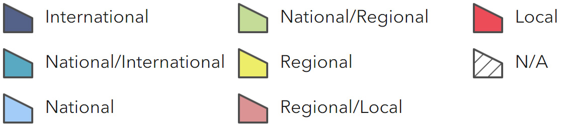
Main Beneficiaries Map
View Main Beneficiaries Map full screen in a new tab View Interactive Map HelpEcosystem service analysis
The following sections show the analysis used to determine key Ecosystem Service opportunities within the area. These opportunities have been combined with the analysis of landscape opportunities to create Statements of Environmental Opportunity. Please note that the following analysis is based upon available data and current understanding of ecosystem services. It does not represent a comprehensive local assessment. Quality and quantity of data for each service is variable locally and many of the services listed are not yet fully researched or understood. Therefore analysis and opportunities may change upon publication of further evidence and better understanding of the inter-relationship between services at a local level.
Note that numbers and figures in the body of the text are based on the 2014 profiles, unless otherwise stated.
Provisioning Services
Food provision
Assets/attributes: main contributors to service –
- Grasslands
- Mixed livestock farming
- Arable land
- Horticulture/ market gardening
- Allotments
State – The soils are moderate or poor with only about 1 percent being grades 1 or 2, 23 percent grade 3 and 9 percent grade 4. The remainder (67 percent) is either urban or non- agricultural.
In 2010, the farmed area is predominantly pastoral with 59 percent classified as grassland or uncropped land. 30 percent is cereals and 6 percent oilseed rape.
The commonest livestock is sheep (71 percent) followed by cattle (21 percent) and pigs (8 percent).
Main beneficiary – Local
Analysis – Historically the area had many mixed farms with wheat an important crop. However, now food production is not an important industry in the NCA. Only 20 percent of the land is farmed and the total farmed area declined between 2000 and 2009 by 9 percent.
Between 2000 and 2009 grass or uncropped land increased by 6 percent, probably reflecting an increased demand in the number of horse paddocks. Oilseeds increased in area by 51 percent while other arable crops fell by 64 percent and cereals by 35 percent. Livestock numbers fell during the same period; sheep by 4 percent but cattle and pigs quite dramatically by 77 percent and 75 percent respectively. This again probably reflects the difficulties of livestock farming on the edge of densely populated urban areas.
Allotment holdings are popular in the NCA providing a good source of cheap and sustainable food as well as opportunities for recreation and education. There is some potential for increasing agriculture but in order for this to be commercially viable specialisation would be necessary, such as rare breeds and niche food markets.
Opportunities – Encourage sustainable farming practices through implementation of soil, land and water best practice management to protect and maintain resources.
Promote the development of specialist food products and markets for locally produced food, especially those associated with rare breeds, low input and extensive livestock management systems. Seek to safeguard food provision through measures such as agri-environment schemes, which also enhance the landscape and biodiversity.
Support and extend where possible the provision of local allotments so that people can grow their own food sustainably and reinforce links between food sources and urban populations. Promote wildlife-friendly management of allotments.
Principal services offered by opportunities –
- Food provision
- Sense of place/inspiration
- Biodiversity
- Recreation
Timber provision
Assets/attributes: main contributors to service –
- Existing woodlands
- Ancient semi-natural woodland
State – Woodland cover is reasonably high at about 13 percent and made up of small woodlands, shaws and wet woodlands in the river valleys.
Woodland is privately owned; the Forestry Commission does not manage any plantations in the NCA. The majority of the woodland cover (89 percent) is broadleaved, of which 20 percent is classified as ancient semi-natural woodland.
Main beneficiary – Local
Analysis – Bringing woodlands back into sustainable active management through coppicing and pollarding would help to improve their biodiversity interest, recreational value and strengthen a sense of place and tranquillity while providing a long-term source of timber, especially hardwoods.
There is scope to extend timber provision within the area although this would probably be most successful linked to production of biomass or firewood provision particularly for local use.
Opportunities – Encourage and stimulate local markets for wood products, particularly around Guildford and north Surrey, such as charcoal, wood fuel and sustainable timber production.
Encourage the re-introduction of traditional management techniques such as pollarding and coppicing, especially in ancient semi-natural woodland and broadleaved woodlands to improve health and biodiversity, strengthen landscape and provide sustainable sources of local wood fuel.
Encourage and promote the planting of new woodlands, where beneficial, to link existing habitats or provide access to quality green space for urban populations.
Principal services offered by opportunities –
- Timber provision
- Biomass energy
- Biodiversity
- Sense of place/inspiration
- Tranquillity
Water availability
Assets/attributes: main contributors to service –
- Relatively low rainfall
- Aquifers, rivers and streams
- Wey Navigation canal
State – The rivers Mole, Hogsmill and Wandle are dependent on the chalk aquifers of the North Downs.
The River Wey is fed by the chalk aquifers of the Hampshire Downs.
Water is abstracted from the Mole and Wey within the NCA for domestic water supply.
The Mole, Hogsmill and Wandle in the NCA have water available for licensing at high and moderate flows. The Wey has water available for licensing only at high flows (London Abstraction Licensing Strategy, Environment Agency. February, 2013; Mole Abstraction Licensing Strategy, Environment Agency. February, 2013; Wey Abstraction Licensing Strategy, Environment Agency. December, 2012). A small portion of the Epsom North Downs aquifer underlies Sutton and Croydon. This is classified as having no water available.
Main beneficiary – Regional
Analysis – The rivers of the NCA are managed as part of the Thames catchment area, one of the driest areas in the country with only about three quarters of the national average rainfall but with the highest population.
All the rivers within the Thames catchment area are managed to protect the drinking water supply for London.
Leakage from water pipes is a particular problem within Greater London where it can be more difficult to access the infrastructure.
Managing demand through water efficiency measures such as water recycling and metering will help to ensure that water supplies are sustainable. All new development should be built to high water efficiency standards. Extending and improving the management of low-lying grasslands, particularly water meadows in the river valleys, would improve their capacity to absorb water.
Good land management practices such as adding organic matter to soils where levels are low could help improve infiltration and reduce diffuse pollution such as ground water run-off.
Increase in number of winter storage reservoirs on farmland would help to regulate seasonal water supplies for agriculture and reduce the need for abstraction.
Opportunities – Encourage the renewal and improvement ofpipe and sewer infrastructure to prevent water leakage.
Promote good soil, land and water management through the codes ofpractice, such as the addition of organic matter to soils where levels are low to assist infiltration, reduce surface water run-off and diffuse pollution.
Extend, link and improve the management ofsemi-natural habitats such as the water meadows and riparian habitats alongside the Wey, Mole and Hogsmillto aid infiltration and increase water storage capacity especially in winter.
Encourage the uptake ofwater saving measures such as best practice in harvesting and recycling rainwater, and greywater recycling, in new and existing developments.
Promote water efficiency and the use of water- efficient devices and water meters among all users; domestic, agricultural and commercial.
Ensure that all new development is built to the highest water efficiency standards as set out in the Code for Sustainable Homes (Code for Sustainable Homes, Department for Communities and Local Government, 2006).
Encourage the building ofwater storage reservoirs on agricultural land to reduce demand on water resources.
Principal services offered by opportunities –
- Water availability
- Regulating water flow
- Regulating water quality
- Climate regulation
- Regulating soil erosion
- Sense of place/inspiration
- Biodiversity
Genetic diversity
No information available.
Biomass energy
Assets/attributes: main contributors to service –
- Existing broadleaved woodlands
State – Existing woodland cover is around 13 percent the majority of which is broadleaved; around 3 percent is ancient semi-natural woodland.
There is currently no large-scale biomass provision within the NCA.
Main beneficiary – Local
Analysis – Existing broadleaved and ancient semi-natural woodland offers the best potential for biomass provision through improved management of woodlands. Potentially there is a large market for biomass and wood products locally.
Reintroduction of coppice management could increase biomass provision and benefit biodiversity and the character of ancient coppiced woodlands.
There is predominantly medium potential yield for short rotation coppice (SRC) throughout the NCA, except for a small patch of low potential around West Horsley and one of high potential around Effingham.
SRC plantations could link and contribute to woodland cover on the edge of existing woodlands and riparian habitats, where it does not disturb semi-natural vegetation.
Miscanthus plantations would probably be best placed in the urban fringe or used to break up views of visually intrusive developments.
Some heathlands and commons have secondary woodland growth from a lack of management or grazing. Restoring the open grassland habitat could provide a short term biomass source.
Opportunities – Encourage local initiatives and markets for wood fuel biomass.
Work with partners and woodland managers to promote and reinstate coppice management of woodlands for biomass and wood fuel. Encourage the planting of SRC along the banks of rivers where it is in keeping with the landscape character and will support biodiversity.
Encourage and support the restoration of open heathlands and commons through the removal of secondary woodland to provide short term biomass and benefit biodiversity landscape.
Principal services offered by opportunities –
- Biomass energy
- Climate regulation
- Biodiversity
- Sense of place/inspiration
- Timber provision
- Regulating water quality
- Regulating water flow
Regulating Services
Climate regulation
Assets/attributes: main contributors to service –
- Soils
- Broadleaved woodland
- Semi-natural vegetation
- Pasture and parkland
- Hedgerows
- Wetlands
- Street trees
- Private gardens
- Urban green space
State – The soils of the NCA generally have a low content (0 to 5 percent).
There are small areas of naturally very wet acid sandy and loamy soils (4 percent), some of the flood plain soils with naturally high groundwater (3 percent) and the freely- draining very acid soils (2 percent) which are peaty at depth or include some organic and peaty topsoils that provide a store of carbon.
Carbon storage is provided by over 3,000 ha of woodland within the NCA and its underlying humus-rich soils.
There are nearly 4,000 ha of grassland and uncropped land and nearly 1,000 ha of Registered Parks and Gardens.
Main beneficiary – Local
Analysis – The majority of the area’s soils are mineral soils that can be low in organic matter.
Carbon will be stored where soils have remained undisturbed for very long periods, including flood plain grasslands, parkland and permanent pasture.
A large proportion of the NCA is urban (59 percent) but still makes a contribution to climate regulation through its street trees, urban green space and private gardens. This can be increased by the installation of green roofs, additional planting of street trees (preferably native broadleaved) and by ensuring all new housing and other developments incorporate high quality greenspace.
Green roofs also make good insulators and can help reduce the need for heating or cooling. In addition they enhance the efficiency of solar panels (Benefits of Green Roofs, Environment Agency). All new development should be built to the highest energy efficiency, where possible meeting the Code for Sustainable Homes (Code for Sustainable Homes, Department for Communities and Local Government, 2006), the national standard for sustainable construction which aims to reduce carbon emissions.
The well-managed woodlands of the NCA are the most efficient at carbon sequestration. However, fragmentation limits their potential to adapt to climate change and store carbon.
Carbon sequestration could be increased in the majority of the area’s soils by increasing organic matter content and by reducing the frequency and extent of cultivations.
Opportunities – Encourage developers and planners to meet the highest energy efficiency standards in all new development, working to the Code for Sustainable Homes.
Promote and encourage planting of street trees, particularly native species, to act as carbon stores. Encourage the good management of existing street trees and urban greenspace.
Promote and encourage the installation and management of green roofs within urban areas to insulate and contribute to energy efficiency.
Support and encourage the reintroduction of active management to existing woodlands, shaws and hedgerows.
Support and encourage the planting of new woodlands, shaws and hedgerows to link and expand woodland cover to increase their resilience to climate change and their ability to sequester carbon and improve habitat connectivity, and strengthen landscape character.
Conserve, manage and restore wetlands, meadows and flood plain grazing.
Encourage farmers and landowners to adopt good land, water and soil management practices.
Encourage farmers to improve soil structure and potential to store carbon through an increase in soil organic matter content, introducing cover crops and restoring arable to permanent grassland where possible.
Principal services offered by opportunities –
- Climate regulation
- Water quality regulation
- Pollination
- Biodiversity
- Geodiversity
- Sense of place/inspiration
- Regulating soil erosion
- Regulating soil quality
Regulating coastal erosion and flooding
No information available.
Regulating water quality
Assets/attributes: main contributors to service –
- Rivers and streams
- Aquifers
- Wetlands, riparian habitats and aquatic vegetation
- Hedgerows, shaws and woodlands
- Soils
State – For information regarding the current state of water quality within this NCA, refer to the Environment Agency (Draft river basin management plan maps).
Main beneficiary – Regional
Analysis – All the rivers in the NCA suffer from high phosphate levels mostly as a result of effluent. The problem is exacerbated by misconnected homes and businesses discharging waste water directly into the rivers.
Run-off, particularly from roads and surface water from dense urban and hard surfaced areas, is another major source of pollution. Urban growth will increase demand on water resources but may also provide opportunities to improve the water environment through the incorporation of measures such as sustainable urban drainage systems (SUDS).
The hedgerow network in some parts of the NCA is in poor repair and has often been replaced by fencing. Restoring hedgerows where possible will help reduce overland flows and remove sediment and pollutants.
Semi-natural habitats including woodland, grasslands, wetlands, reedbeds and bankside vegetation can also act as effective filters of pollutants and sediment.
Opportunities – Encourage water authorities to increase the detection and correction of misconnections to reduce discharge of pollutants directly into rivers.
Encourage the identification of sources of pollution and seek and promote long-term solutions.
Encourage the adoption of Nitrate Vulnerable Zone measures where appropriate.
Work with land managers and partners at a catchment scale to coordinate implementation of measures such as buffering water courses, improving vegetation cover on banks, limiting stock access and restoring riparian habitats to filter effluents and pollutants and reduce sediment loss.
Encourage the restoration and good maintenance of the hedgerow network, particularly on slopes close to rivers, to capture run-off and help to filter out pollutants. Extend and improve the management of river meadows, wetlands and reedbeds so that they can trap and filter pollutants more effectively.
Encourage and support the planting of new native woodlands, shaws and field boundary trees to help filter pollutants.
Ensure all new development incorporates SUDS.
Principal services offered by opportunities –
- Regulating water quality
- Water flow
- Soil quality
- Soil erosion
- Biodiversity
Regulating water flow
Assets/attributes: main contributors to service –
- Rivers and streams
- Flood plains
- Wetlands
- Infrastructure
- Agricultural land
- Semi-natural habitats including hedgerows and woodlands
- Soils and geology
State – The rivers in the NCA form part of the larger Thames catchment and flood management area. They are fed by headwaters from the South, North and Hampshire Downs in the neighbouring NCAs.
There are several large centres of population in the NCA including Beddington, Cobham, Epsom, Guildford and Leatherhead which are potentially at risk of flooding from the rivers Mole, Wey and tributaries. This is mainly due to river flooding but in some places, for instance Croydon, surface water flooding is also an issue (Thames Catchment Flood Management Plan, Environment Agency Summary Report. December, 2009).
Main beneficiary – National
Analysis – The impermeable nature of the clay soils in the NCA means that little water infiltrates the ground and water levels rise quickly in response to rainfall. In addition, dense urban areas with extensive hard surfaces exacerbate rapid run-off.
Climate change may exacerbate problems of flooding through an increase in frequency and intensity of rainfall events.
All the rivers running through the area have been heavily modified. Restoration to a more natural state would help to reduce the risk of flooding while greatly enhancing their landscape character.
Development pressure is high in the NCA including on existing flood plains. A key element in alleviating or preventing future flood events will be avoiding inappropriate development on flood plains and managing them well so that they can function effectively.
Measures to improve flood plain capacity to absorb excess water could include restoring permanent flood plain grazing, extending wetlands and enhancing riparian habitats.
Creation of seasonal flood storage lagoons on farmland may help to alleviate flooding pressure.
Within urban areas prone to flooding the most effective defence can be to design buildings to be resilient or resistant to flooding. The Environment Agency’s preferred policy at Guildford is to encourage greater flood resilience within new development.
The Lower Mole Valley is currently defended through the Lower Mole flood alleviation scheme which includes the realignment of the eastern branch of the Mole, the Ember channel, to remove excess water swiftly. Future improvement in flood defences will focus on designing new development to minimise flood risk.
The urban environment can also be adapted to mitigate flooding through, for instance, installation of sustainable urban drainage systems including swales, rain gardens and green roofs as well as permeable pavements. Greenspace can help store and absorb excess water.
Opportunities – Work with local authorities to avoid inappropriate development on flood plains.
Work with partners to restore natural river channels, improve river morphology to slow fluvial flows and create flood storage and remove artificial barriers to reduce flood risk.
Where possible work with farmers, landowners and water authorities to reconnect rivers with their flood plains and extend and link flood plains to improve their capacity to absorb flood waters
Encourage farmers and landowners to manage and restore permanent grassland, hedgerows, shaws, woodland, wetlands and riparian habitats in good condition to improve infiltration and slow run-off, and seek opportunities to provide further flood storage capacity.
Support the creation of backwaters as a refuge for aquatic species in times of drought, allowing seasonal inundation of wetlands and flood plain pastures as part of flood alleviation measures, reflecting the policies of the Thames Catchment Flood Management Plan, as well as sustaining wetland habitats.
Promote the better management of existing green spaces to improve rates of absorbance of surface waters.
Promote urban greening measures such as rain gardens and green roofs where surface water flooding is identified as a significant risk to increase infiltration.
Encourage the installation of sustainable urban drainage systems in all new developments.
Principal services offered by opportunities –
- Regulating water flow
- Regulating water quality
- Regulating soil quality
- Regulating soil erosion
- Climate regulation
- Sense of place
- Biodiversity
- Pollination
- Geodiversity
Regulating soil quality
Assets/attributes: main contributors to service –
- Soils
- Semi-natural vegetation
State – There are eight soilscapes within the NCA.
The most significant is slowly permeable, seasonally wet, slightly acid but base-rich loamy and clayey soils, covering 52 percent of the area.
Other significant soil types are loamy soils with naturally high groundwater (15 percent), freely draining slightly acid but base-rich soils (11 percent) and freely draining slightly acid loamy soils (9 percent).
To the north-east of the NCA, within the Greater London Area, the area is very urban and the amount of exposed soil is limited.
Main beneficiary – Local
Analysis – The majority of the soils in the NCA, especially the slowly permeable, seasonally wet, slightly acid but base-rich loamy and clayey soils, are subject to problems of diffuse pollution. They are easily damaged when wet and may suffer from compaction and capping which in turn leads to poorer water infiltration and increased diffuse pollution from increased surface water run-off. This can be exacerbated by the application of manures during periods of flooding or high groundwater levels.
Compaction and capping can occur from machinery, intensive or insensitive livestock grazing or heavy recreational use.
Climate change may bring more intense rainfall events which are likely to increase diffuse pollution problems.
Good soil structure management will aid water infiltration thus improving aquifer recharge, and help to prevent pollution of groundwater.
Increasing permanent semi-natural vegetation cover can improve infiltration slow run-off and filter out sediments.
Opportunities – Encourage agricultural practices which reduce compaction and capping such as re-routing and limiting the use of heavy machinery, direct drilling, including fallow cropping in rotation, timely application of manures, careful control of livestock and managing grazing regimes to increase water infiltration and reduce diffuse pollution.
Encourage farmers and landowners to adopt catchment- wide landscape scale measures to improve soil structure, including increasing organic matter content and careful applications of nutrients, pesticides, herbicides and fertilizers.
Principal services offered by opportunities –
- Regulating soil quality
- Food provision
- Climate change
- Water availability
- Regulating water flow
- Regulating water quality
- Regulating soil erosion
- Biodiversity
- Geodiversity
Regulating soil erosion
Assets/attributes: main contributors to service –
- Soils
- Semi-natural vegetation including grasslands, hedgerows, shaws, woodlands
- Riparian habitats
State – Soil erosion is not a major problem for the NCA. The commonest soil type, slowly permeable, seasonally wet, slightly acid but base-rich loamy and clayey soils, accounting for 52 percent of the soilscape, is not very prone to soil erosion.
Some of the soils are prone to erosion but these tend to occur in urban areas where soil exposure is much reduced.
Main beneficiary – Local
Analysis – Maintenance of permanent ground cover and management of buffer strips, hedgerows, shaws and woodland, particularly adjacent to water courses, may help reduce cross- land water flows and subsequent erosion.
Opportunities – Encourage good land management practices to minimise erosion problems such as avoiding compaction, increasing organic matter content in soils and timely / reduced arable cultivations, to improve soil structure.
Encourage installation of buffer strips adjacent to rivers and water courses.
Restore and maintain hedgerows, manage and replant shaws, woodland and riparian habitats to control cross- land water flow and reduce soil erosion whilst improving wildlife habitat and sense of place.
Principal services offered by opportunities –
- Regulating soil erosion
- Regulating soil quality
- Food provision
- Regulating water quality
- Regulating water flow
- Biodiversity
- Sense of place/inspiration
Pollination
Assets/attributes: main contributors to service –
- Semi-natural habitats
- Parkland
- Woodland
- Roadside verges
- Hedgerows
- Field margins
- Gardens and urban green spaces
- Allotments
State – The semi-natural habitats and parklands of the NCA support a variety of pollinators, while gardens within the urban areas also make significant contributions.
Semi-natural vegetation provides a key source of pollen and nectar for pollination of commercial crops.
Main beneficiary – Local
Analysis – Pollinating insects are supported by a range of semi-natural habitats, particularly species-rich grassland in the river valleys, the field boundary network, shaws and broadleaved woodlands. Increasing these habitats and their management and connectivity will benefit pollinators. The hedgerow network is in poor condition over much of the NCA, increasing the isolation of habitats.
Pasture benefits from pollination to increase and support the sward variety and improve the quality of food for livestock. Clovers which are beneficial for the health of pasture rely on bee pollination. Allotments and home grown crops also rely on bees.
Use of agricultural pesticides and herbicides can have a detrimental impact on pollinators.
Urban green spaces, allotments, parks and gardens and road verges can all also provide a good refuge for pollinators with a wide variety of pollen and nectar often available.
Opportunities – Encourage conservation and restoration of semi-natural vegetation, such as species-rich pastures, meadows, verges and flood plain grazing, to connect fragmented habitats and support a wide variety of pollinators.
Promote the development of green roofs, urban parks and high quality green infrastructure to provide urban habitats for pollinators.
Encourage improved and timely management and the planting of verges with native nectar- rich flowers alongside major routes such as the M25, A3 and A247 to extend flowering times and support a wider range of pollinators.
Raise awareness of the importance of pollinators with all land and woodland managers and the wider public and help them identify and reduce threats to pollinating species.
Support the creation and restoration of the hedgerow network to support pollinators and provide links between habitats.
Principal services offered by opportunities –
- Pollination
- Food provision
- Sense of place/inspiration
- Pest regulation
- Biodiversity
Pest regulation
Assets/attributes: main contributors to service –
- Semi-natural habitats
- Hedgerows
- Road verges and field margins
State – Semi-natural vegetation and habitats support a variety of natural predatory species including invertebrates, birds and mammals.
Main beneficiary – Local
Analysis – In this predominantly urban NCA, fragmentation and breaks in the ecological network result in a lack of connectivity which inhibit the movement of predatory species. Extending the area and improving the connections between these habitats would allow pest predators to move more easily, for instance into areas of crops.
Opportunities – Encourage farmers and landowners to manage, improve and expand habitats and ecological networks, to aid the movement of predatory species through the landscape, thus increasing biodiversity and benefitting pest regulation and pollination.
Encourage creation and restoration of the hedgerow network to link habitats and strengthen the structure of the landscape.
Promote farming and gardening methods which reduce impact on beneficial species, such as organic pest control.
Promote the management of green space and local nature reserves for wildlife to encourage a greater range of invertebrates.
Principal services offered by opportunities –
- Pest regulation
- Food production
- Biodiversity
- Sense of place/inspiration
- Pollination
Cultural Services
Sense of place/inspiration
Assets/attributes: main contributors to service –
- River valleys
- Commons
- Historic parklands
- Ancient semi-natural and other woodland
- Urban greenspace
- Urban parks
State – The NCA is very urban but gets its sense of place in part from its semi-natural habitats such as the river valleys and commons.
The river valleys of the Mole and the Wey towards the west are more pastoral and tranquil with flood plain grasslands and riparian woodlands.
Main beneficiary – Local
Analysis – The woodlands, parklands, commons, fragmented farmland with scattered farmsteads, small traditional villages and pastoral river valleys provide an escape from the pressures of urban living for many residents of the NCA. However, the loss and poor maintenance of hedgerows have weakened the traditional field patterns.
Parklands are an important feature with their distinctive landscapes, avenues, and trees. However, several, such as Crystal Palace, are on the English Heritage at Risk register and others are now intensively farmed.
Commons, both urban and more rural, are valued by local residents and give the surrounding settlements a focus.
Land around the outskirts of London has been designated as Green Belt but it often has an untidy, unkempt feel. This is due to the urban fringe influences, a rise in non-agricultural use, – the conversion of fragmented agricultural land to poorly managed horse paddocks and neglected hedges, sometimes with gaps or replaced by wire fencing.
All the rivers have been heavily modified. Restoration to a more natural state would help to reduce the risk of flooding while greatly enhancing their landscape character.
Only a small portion of the NCA is designated as part of the Surrey Hills but the AONB does lie close to the boundary between Ash and Fetcham. Care should be taken to ensure that any development within the NCA does not impinge on the quality of the landscape of the AONB.
Within the London Boroughs, some remnants of the natural landscape, for instance commons or woodland, survive as described in London’s Natural Signatures (London’s Natural Signatures: the London Landscape Framework. Natural England, 2011). Improvement to the management of these features would make a direct and powerful contribution to the sense of place and local distinctiveness. For example, the Wandle has a natural signature of water meadows echoing the meandering course of the river, backed by bands of wet woodlands.
Opportunities – Where open to the public, encourage the management and restoration of landscaped parklands for their contribution to a sense of well-being and to protect their historical value.
Support and encourage the development of green infrastructure in urban / suburban areas in all new developments to enhance landscape character, link to the wider countryside and improve a sense of health and community cohesion. Encourage farmers and landowners to manage and restore hedgerows to strengthen historic field patterns, to support landscape character and improve wildlife habitat and connectivity.
Support and encourage the multifunctional use of Green Belt land around Greater London for recreation as well as for agriculture and woodland.
Encourage the re-introduction of traditional woodland management, such as coppicing and pollarding, to strengthen the landscape character and provide biodiversity and recreational benefits.
Plan, promote and encourage the improved grazing management of horse paddocks and the restoration of hedged field boundaries.
Encourage and support the implementation of the Surrey Hills AONB Management Plan.
Ensure that any development does not adversely affect the special qualities of the Surrey Hills AONB, including through light noise and air pollution.
Encourage the use of ‘natural signatures’ where possible for new developments within Greater London.
Principal services offered by opportunities –
- Sense of place/inspiration
- Biodiversity
- Sense of history
- Recreation
- Food provision
- Timber provision
- Geodiversity
Sense of history
Assets/attributes: main contributors to service –
- Industrial heritage
- Historic towns and villages
- Registered Parks and Gardens
- Listed buildings
- Scheduled Monuments
- Military defences
- Ancient woodland Commons
- Veteran trees
State – There are 25 Scheduled Monuments and 1,260 Listed Buildings within the NCA, along with historic market towns such as Guildford and smaller historic rural villages such as West Horsley and Ockham.
The 14 Registered Parks and Gardens and designed estates reflect the period of wealthy merchants and landed gentry moving out of London between the 17th and 19th centuries. Several buildings, parklands and Conservation Areas are considered ‘at risk’.
Within the settlements there are a number of traditional buildings, while on the rivers there are remnants of past industrial heritage.
Ashstead Common is a 200 ha ancient wood pasture site with over 2,300 ancient oak pollards. There is also a Roman Villa site on the Common. Although it is known that the Common was wooded since 1600, the heavy, difficult to work, clay soils make it likely that the woodland cover is far older.
Main beneficiary – Local
Analysis – The rivers in the NCA have a long industrial heritage. The Wey, Mole, Hogsmill and Wandle were all exploited for their water power; the Domesday Book records mills on the banks of the Hogsmill (Hogsmill Information Pack. Environment Agency, 2013).
Abandoned and derelict mills and water features are historical reminders of past land use. The most famous examples of mills are probably those on the Wandle at Colliers Wood where the remains of the Liberty Mills and William Morris’ dyeworks can still be seen.
Isolated farmsteads, market towns and small rural villages built in the vernacular style and local materials reflect historical land use.
Improved woodland management employing techniques such as coppicing and pollarding will ensure long-term wooded character and retain characteristic features.
Opportunities – Work with partners and local interest groups to seek opportunities to enhance the setting and interpretation of assets such as Liberty Mills, to increase public awareness and their enjoyment and appreciation of the local heritage.
Increase public awareness of the past industrial heritage of the rivers through improved interpretation such as educational trips and information boards and restoration and re-use of historic industrial buildings where appropriate. Encourage the conservation and restoration, including re use where appropriate, of historic parklands, Scheduled Monuments and landscape features, particularly those ‘At Risk’.
Work with partners to encourage respect for landscape character and use of traditional methods and materials in new development around villages.
Encourage the conservation, repair and restoration of historic buildings, including farmsteads, using local traditional materials to strengthen sense of history and landscape.
Encourage reintroduction of traditional woodland management techniques such as coppicing and pollarding to ensure long term viability and presence of trees in the landscape.
Promote and support grazing on historic commons, particularly using rare breeds typical of the area.
Principal services offered by opportunities –
- Sense of history
- Sense of place/inspiration
- Biodiversity
- Recreation
- Geodiversity
- Timber provision
Tranquility
Assets/attributes: main contributors to service –
- Woodlands
- Parklands and Commons
- River valleys
- Urban green spaces
- Farmland
State – According to 2007 Campaign for Rural Protection data, less than 1 percent of the NCA can be considered undisturbed. 60 percent is urban and over 39 percent is disturbed.
The west of the area is less densely populated. Generally tranquillity is to be found in pockets scattered across a heavily developed area such as in the parklands, on commons and in the river valleys.
Main beneficiary – Local
Analysis – Tranquillity is not a strong characteristic of the area. A large proportion of the NCA in the north- east is close to Greater London and is urban and heavily disturbed by development, housing, light pollution and noise / intrusion from major transport routes such as the M25 and A3.
Some small pockets of tranquillity, however, can still be found within the farmed landscape, the area’s commons, woodlands and pastoral river valleys, particularly between Guildford and Ash, and Guildford and Fetcham in the south-west.
The Surrey Hills AONB lies adjacent to the NCA along its northern boundary, and any future development here needs to be carefully considered, to avoid impacting on the special qualities of the AONB.
Opportunities – Enhance and maintain remaining tranquil areas by conserving and managing existing semi-natural habitats, particularly, woodlands, shaws, hedgerows, commons and farmed landscape.
Seek to improve tranquillity by incorporating features such as green spaces, hedgerows, ponds and woodland into new and existing development.
Retain the transport network within existing corridors and buffer and shield by tree planting and hedgerows to reduce intrusion/disturbance.
Ensure that tranquillity is taken into account when managing urban green spaces and parks within urban fringes and Greater London.
Promote and encourage the inclusion of high quality greenspace in all new developments to provide local pockets of tranquillity within urban areas to benefit the public and wildlife.
Ensure that new housing, development and its associated infrastructure, does not intrude upon the wider landscape and the special qualities of the Surrey Hills AONB (including light, noise and air pollution).
Principal services offered by opportunities –
- Tranquillity
- Sense of place/inspiration
- Sense of history
- Recreation
- Biodiversity
Recreation
Assets/attributes: main contributors to service –
- Rights of way Ashtead Common
- National Nature Reserve
- Registered Parks and Gardens, country parks
- Local Nature Reserves
- Commons Rivers and river valleys
- Urban parks and green space
State – The NCA is well provided with 400 km of rights of way and nearly 9 percent accessible land, including Open Access land on Commons, and woodlands.
The river valleys are well used for quiet recreation, the Wey for example being used for both walking and canoeing.
Main beneficiary – Local
Analysis – The NCA has good opportunities for recreation with footpaths, Commons, Local Nature Reserves, country parks and Ashtead Common National Nature Reserve al providing greatly valued assets.
Recreational facilities are usually low-key, associated with walking, cycling and horse-riding as well as fishing and canoeing on rivers.
However, access provision and recreational facilities are not evenly spread across the NCA. Croydon, Mitcham, New Malden, North Cheam, Sutton and Thornton Heath are all considered to be Areas of Deficiency as defined by the Greater London Authority.
Opportunities – Encourage greater provision where possible both of green space and rights of way for those areas within the NCA that are currently poorly provided for.
Maintain, promote and manage public rights of way, recreational facilities, historical and cultural sites, and natural heritage resources to provide benefit to local residents while maintaining intrinsic value.
Work with partners to support and implement the Surrey Rights of Way Improvement Plan.
Encourage all new developments to include high quality green infrastructure and open space for recreation.
Principal services offered by opportunities –
- Recreation
- Sense of place/inspiration
- Tranquillity
Biodiversity
Assets/attributes: main contributors to service –
- European and nationally designated sites
- Priority habitats and species
State – A tiny proportion (0.01 percent) of the NCA is designated as part of the Thames Basin Heaths Special Protection Area (SPA) for its breeding populations of Dartford warbler, nightjar and woodlark. Ashtead Common NNR is designated for its pollarded oaks and invertebrate assemblages. The 8 SSSI within the NCA cover about 900 ha, just under 3 percent of the area. 59 percent are deemed to be in favourable condition and 41 percent unfavourable but recovering due to improved management.
There are 855 ha of ancient semi-natural woodland mainly in central and western parts of the NCA. Other significant areas of priority habitats include lowland broadleaved woodland (5 percent) and fens (1 percent).
Main beneficiary – Regional
Analysis – The Thames Basin Heaths SPA is very fragmented and surrounded by a large population. This has led to disturbance of ground nesting birds and abandonment of nests. To ease recreational pressure on the SPA, developers and Local Planning Authorities have been asked to provide and develop suitable alternative natural green space (SANGS).
Ashtead Common NNR in the centre of the NCA near Epsom supports a rich mosaic of habitat types from rough grassland and ponds to woodland. Two ponds, the Stew Pond and Great Pond are medieval in origin. Several fine old pollards of pedunculate oak, characteristic of former wood pasture are of special importance for the rare insects and invertebrate assemblages associated with them.
Epsom and Ashtead Commons SSSI and Esher Common SSSI are former heaths and still retain patches of heather but suffer from a lack of grazing management and bracken, scrub and secondary woodland is encroaching.
20 percent of the woodland is classed as ancient semi-natural woodland. It is in a highly fragmented state and undermanaged but could be strengthened by linking through hedgerows or new plantations of native trees and bringing woodland back into coppice management.
Other semi-natural habitats such as grassland and lowland meadows are highly fragmented and thus species movement is constrained, particularly as a result of major transport routes and urban sprawl. Improving the condition and extent of hedgerows, shaws and broadleaved woodland, as well as maintaining Local Nature Reserves and other local sites in good condition will help to improve connectivity, strengthen the ecological network and benefit the landscape.
There has been considerable work to clean up the rivers of the NCA in recent years, in particular the Hogsmill and Wandle. However, the prevalence of invasive species, for example Himalayan balsam and signal crayfish remains as issues.
All the rivers within the NCA have been heavily modified often to provide power to water mills and also for flood prevention but their morphologies are now detrimental to wildlife. For instance, migrating fish can be hindered by obstacles such as weirs.
Opportunities – Promote awareness among the wider public locally of the importance of the Thames Basin Heaths SPA for rare birds such as the Dartford warbler, nightjar and woodlark and their susceptibility to disturbance.
Work with Local Planning Authorities and developers to provide SANGS for recreation locally to reduce disturbance pressure on the SPA.
Encourage the restoration and good management of ponds, grassland and hedgerows, particularly where they link ancient semi-natural woodland or other semi-natural habitat, to improve connectivity for wildlife and strengthen landscape character.
Encourage good management for all SSSIs, Local Nature Reserves and other local wildlife sites so that they can act as steppingstones for wildlife between fragmented sites within the NCA
Manage pollarded trees on Ashtead Common NNR and support the re-introduction of pollarding techniques as part of active woodland management to benefit biodiversity and increase landscape and historic interest.
Promote the use of the best practice guidance provided by the Surrey County Council for the management of horse pasture (Surrey County Council).
Encourage the restoration and good management of heathland on Ashstead and Esher Commons through improved grazing regimes, bracken control, clearance of scrub and removal of secondary woodland to enhance biodiversity interest and strengthen landscape character.
Encourage the re-introduction of active management of ancient semi- natural woodland and broadleaved woodlands to improve age structure, diversity, supply timber products / wood fuel locally, as well as provide benefits for biodiversity, landscape and recreation.
Plan and create new woodlands, shaws and field boundary trees to link fragmented woods and buffer developments to increase biodiversity, landscape character and tranquillity.
Raise awareness among nurseries and the wider public of the problems caused by the introduction of non- native invasive species, particularly to rivers and ponds.
Support improvements to the morphology of the local rivers, restoring them to more natural courses, to benefit wildlife.
Principal services offered by opportunities –
- Biodiversity
- Sense of place/inspiration
- Regulating water quality
- Regulating soil erosion
- Recreation
- Climate regulation
Geodiversity
Assets/attributes: main contributors to service –
- Geology
- Soils
State – The NCA does not have high national geological interest with only one mixed national and no local geological sites. The geological interest of the mixed site lies outside the NCA.
Main beneficiary – Local
Analysis – The area does not have a lot of exposed geological interest. However a local geology site to explain the geological processes that formed the area, for instance the change in course of the river Wey after the last ice age and the development of river terraces, could help to encourage greater interest in geodiversity and foster a sense of place.
Opportunities – Explore the possibility of creating a new local geological site for educational purposes to raise awareness of the role of geological processes locally.
Principal services offered by opportunities –
- Geodiversity
- Sense of place/inspiration
- Sense of history