

National Character Area 47
Southern Lincolnshire Edge - Analysis: Ecosystem Services
Analysis supporting Statements of Environmental Opportunity
The following analysis section focuses on a selection of the key provisioning, regulating and cultural ecosystem goods and services for this NCA. These are underpinned by supporting services such as photosynthesis, nutrient cycling, soil formation and evapo-transpiration. Supporting services perform an essential role in ensuring the availability of all ecosystem services.
Bodiversity and geodiversity are crucial in supporting the full range of ecosystem services provided by this landscape. Wildlife and geologically-rich landscapes are also of cultural value and are included in this section of the analysis. This analysis shows the projected impact of Statements of Environmental Opportunity on the value of nominated ecosystem services within this landscape.
Further analysis on landscape attributes and opportunities for this NCA is contained in the Analysis: Landscape Attributes & Opportunities section.
Natural Capital
Further information on Natural Capital within this NCA is contained in the Natural Capital and Key Ecosystem Services section.
The Southern Lincolnshire Edge NCA provides a wide range of benefits to society. Each is derived from the attributes and processes (both natural and cultural features) within the area. These benefits are realised through the ‘ecosystem services’ that flow from the ‘ecosystem assets’ or ‘natural capital’ of a place.
Natural capital means ‘the elements of nature that directly or indirectly produce value to people, including ecosystems, species, freshwater, land, minerals, the air and oceans, as well as natural processes and functions’ (Natural Capital Committee, 2017).
Ecosystem Services Main Beneficiaries
The below map displays the main beneficiaries of each ecosystem service identified within this NCA and neighbouring NCAs. These range from being of international importance to local importance. Some services have not been assessed within all NCAs, and therefore in some NCAs are displayed as “N/A” (not applicable).
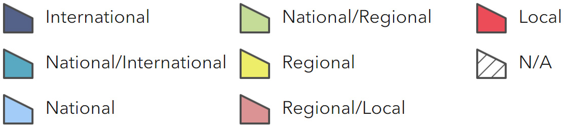
Main Beneficiaries Map
View Main Beneficiaries Map full screen in a new tab View Interactive Map HelpEcosystem service analysis
The following sections show the analysis used to determine key Ecosystem Service opportunities within the area. These opportunities have been combined with the analysis of landscape opportunities to create Statements of Environmental Opportunity. Please note that the following analysis is based upon available data and current understanding of ecosystem services. It does not represent a comprehensive local assessment. Quality and quantity of data for each service is variable locally and many of the services listed are not yet fully researched or understood. Therefore analysis and opportunities may change upon publication of further evidence and better understanding of the inter-relationship between services at a local level.
Note that numbers and figures in the body of the text are based on the 2014 profiles, unless otherwise stated.
Provisioning Services
Food provision
Assets/attributes: main contributors to service –
- Soils
- Agricultural crops (arable and grassland)
- Semi-natural habitats (limestone and neutral grassland)
State – This is a productive arable area. The majority of farmland soils are Grade 2 (36 per cent) or Grade 3 (59 per cent). There are also mixed and livestock farms, particularly on heavier soils to the east.
In 2009 cereals were the primary crop, taking up almost half of agricultural land, but oilseeds (12 per cent of the NCA) and cash roots (9 per cent) were also significant. Grassland and uncropped land accounted for a further 17 per cent of agricultural land.
Grazing land occurs on the heavier soils to the east and in 2009 supported sheep (15,100) and cattle (3,300). 9,200 pigs were kept on a mixture of outdoor and indoor pig units.
Main beneficiary – Regional
Analysis – This is a productive area for agriculture, producing cereals, oilseeds, root crops, pigs and poultry, contributing to employment, the local economy and supporting local services. The potential to increase food production is good, depending on advances in crop varieties, soil and water management and agricultural technology.
The opportunities to increase the efficiency of food production is also good; farms are of a scale where investment in new technology, such as precision farming equipment, and infrastructure, such as rainwater harvesting systems and renewable energy, is likely to be financially viable.
Improvements in soil quality are likely to be particularly important in this area in terms of improving productivity and environmental efficiency of farming. The free-draining nature of the underlying geology makes it particularly important to maximise organic matter and protect soil Structure, to aid water retention and sustain crop growth during dry spells.
Good soil structure and high organic matter content could also help to limit soil erosion, particularly wind erosion to which the open, windswept, larger fields on higher ground can be prone. Green manures could be beneficial in helping to build organic matter on farms without livestock, and by providing cover over winter to reduce erosion.
As even good condition soils on the plateau are likely to be prone to drying out, having reliable on-farm sources of water will also be important and climate change may increase the demand for on-farm reservoirs and water storage tanks. Farms should implement ways of saving and re-using greywater and rainwater, to limit use of treated mains water and water abstracted from ground and surface sources. (See also text under water availability below.)
The Renewable Energy Plant at Sleaford plans to re-use the ash from burning straw in the plant as fertiliser on agricultural land. Trials to establish the benefits and impacts of this could be a really useful contribution from this area to inform food production in other parts of the country.
Opportunities – Provide information, advice, training and other support to help farmers use new technology, such as precision farming, that reduces the negative environmental impacts of food production. Specific measures could include facilitating machinery rings, demonstration sites and farmer-to-farmer knowledge exchange.
Provide information, advice, training and other support to help farmers enhance soil structure and organic matter (through best practice and measures such as minimum tillage, controlled farm traffic and green manures) thereby minimising soil erosion, run-off, drought damage to crops and need for water abstraction.
Provide information, advice, training and other support to help farmers minimise water use and capture and re-use greywater and rainwater, thereby improving food production and reducing the need for water abstraction.
Support research into the benefits and impacts of applying ash from straw-fired power plants to agricultural land, and disseminate to the agriculture industry in other areas.
Principal services offered by opportunities –
- Food provision
- Water availability
- Climate regulation
- Regulating water quality
- Regulating water flow
- Regulating soil quality
- Regulating soil erosion
- Biodiversity
Timber provision
Assets/attributes: main contributors to service –
- Soils
- Woodland
State – Woodland cover is very low in this NCA at only 2,136 ha (approximately 4 per cent of the NCA). Where woodland does occur it tends to be in small blocks and shelterbelts and is generally not actively managed for timber. There are no major sawmills in the NCA.
Main beneficiary – Local
Analysis – Existing woodland occurs mostly in small, isolated fragments. Much of it does not receive active management and could benefit from some management for timber extraction.
The potential to increase timber production is limited by the sensitivity of the open landscape to new woodland planting. However, consideration should be given to planting of new woodlands in appropriate places that help reinforce landscape character and provide ‘stepping stones’ to help wildlife move through an otherwise quite impermeable landscape. Such tree planting could provide timber on a small-scale.
Opportunities – Explore opportunities for tree planting in locations where it will produce viable timber while helping to reduce wind erosion of agricultural soil, intercept run-off from agricultural land, connect isolated fragments of woodland and/or provide stepping-stones for woodland species.
Principal services offered by opportunities –
- Timber provision
- Climate regulation
- Regulating water quality
- Regulating soil erosion
- Regulating soil quality
- Sense of place/inspiration
- Tranquillity
- Biodiversity
Water availability
Assets/attributes: main contributors to service –
- Watercourses
- Limestone aquifer
- Soils
- Farm reservoirs
State – The Limestone Edge forms a watershed between the major river basins of the Trent to the west and Anglian rivers to the east.
The Lincolnshire Limestone aquifer is regionally important and large demands are placed upon it to meet domestic, industrial and agricultural water supplies, as well as supporting base flows to rivers and supporting local surface water features.
The Lincolnshire Limestone can be up to 40 m thick, and groundwater movement within the aquifer is generally west to east. In the west of the area the limestone outcrops at the ground surface allowing rainfall to recharge the aquifer. The limestone becomes confined as it is overlain by younger deposits to the east. Although abstraction takes place mainly from the confined region, the aquifer becomes too deep and the quality is considered to be too poor to exploit more than a few kilometres east of the outcrop area.
The main rivers in the NCA are the River Slea in the south of the NCA and the River Witham and Fossdyke Canal in the far north of the NCA. In the Lower Witham channel (and associated tributaries) and Lower Bain there is water available for abstraction at high and medium flows, restricted water available at medium/ low flows, but no water available for abstraction at low flows. Upstream of Leasingham there is no water available for abstraction except at very high flows (Witham Catchment Abstraction Management Strategy, Environment Agency, 2013).
The Witham catchment benefits from the Trent Witham Ancholme River Transfer Scheme, a key infrastructure link for managing water resources, to maintain summer water levels and meet abstraction needs (River Basin Management Plan Anglian River Basin District, Environment Agency, 2009).
Main beneficiary – Regional
Analysis – Quarry operators are encouraged to maximise the amount of groundwater recharge they provide so that water is retained locally.
Rainwater harvesting is currently actively promoted, particularly amongst the agriculture and industrial sectors. A suite of booklets has been produced by the Environment Agency, Natural England, Cranfield University, NFU, and the UK Irrigation Association which cover many aspects of water use in the agriculture sector.
Spray irrigators are provided with advice on water efficiency and irrigation scheduling. There are various agricultural water efficiency projects underway. Water security groups have been set up and consist of regional and area Environment Agency staff. The approach is to encourage farmers to improve water security. For example, letters have been sent to farmers including information on extending the irrigation season, the impact of climate change, sharing resources and high flow reservoirs (Witham Catchment Abstraction Management Strategy, Environment Agency, 2013).
New development should be planned and existing development adapted to incorporate sustainable urban drainage systems and water-saving features, to minimise demand on water from treatment plants.
Opportunities – Continue to work with quarry operators, agricultural contractors, farmers and other businesses to support implementation of water-saving measures, capture and re-use of greywater and rainwater and reduce demand for abstraction.
Plan new development and adapt existing development to incorporate sustainable urban drainage systems and water-saving features.
Provide information and advice for householders on how to minimise water consumption.
Principal services offered by opportunities –
- Water availability
- Food provision
- Climate regulation
- Regulating water quality
- Regulating water flow
- Regulating soil quality
- Regulating soil erosion
- Biodiversity
Genetic diversity
No information available.
Biomass energy
Assets/attributes: main contributors to service –
- Soils
- Woodland
- Biomass crops
State – A 38MW straw-fired power plant was established in Sleaford in 2013. It is anticipated it will burn 240,000 tonnes of straw per year, sourced primarily from farms within a 50-kilometre radius. The intention is to recycle the ash as crop fertiliser (Sleaford).
There are two large capacity biomass boilers, supplying 312 kWH (Forestry Commission, 2011).
The NCA has a generally medium potential for short rotation coppice (SRC). The potential miscanthus yield in the NCA varies between high potential yield to the immediate north, east and south of Sleaford to a band of low potential yield to the west of Sleaford running north to Lincoln. There are also a few areas of medium potential yield, for example around Waddington in the north-west of the NCA (For information on the potential landscape impacts of biomass plantings within the NCA, refer to the tables on the Natural England website).
In 2010 the East Midlands had the highest levels of biomass production on farms in England – with 52 per cent of farms producing biomass to produce biogas, and 54 per cent of farms producing other forms of biomass (Diversification and Renewable Energy Production on Farms in England – 2010 Dataset, Defra, 2013).
Main beneficiary – Regional
Analysis – Existing woodland occurs mostly in small, isolated fragments. Much of it does not receive active management. Management for wood fuel extraction would, in some cases, be beneficial for wildlife.
The potential to increase wood fuel production is limited by the sensitivity of the open landscape to new woodland planting. However, consideration should be given to planting of new woodlands in appropriate places that help to reinforce landscape character and provide ‘stepping stones’ to help wildlife move through the landscape. The most appropriate parts of the NCA for new woodland planting include the eastern edge, the escarpment and the south-west corner.
There could be opportunities to include tree planting for biomass in new developments, where it could achieve multiple objectives of screening new developments, providing shade to help keep buildings cool during hotter summers and providing a renewable fuel to heat houses, offices and industrial buildings.
Opportunities – Explore opportunities for production of woody biomass from existing woodlands, where this is compatible with or beneficial to nature conservation objectives.
Explore opportunities for new woodland planting to produce woody biomass, particularly along the eastern edge and south-west corner of the NCA.
Explore opportunities to incorporate tree planting into new developments to provide a local source of fuel while also screening new development and providing shade to help regulate temperatures inside buildings.
Principal services offered by opportunities –
- Biomass energy
- Food provision
- Climate regulation
Regulating Services
Climate regulation
Assets/attributes: main contributors to service –
- Soils
- Woodland
- Other semi-natural habitats (unimproved/ semi-improved grassland)
State – The mineral soils over most of the NCA have a low carbon content (0-5 per cent) with carbon levels likely to be particularly low in areas of continuous arable cultivation. There are scattered pockets of soils with a higher carbon content associated with small areas of naturally wet very acid sandy and loamy soils (covering 2 per cent of the NCA) which contain organic topsoils and the loamy and sandy soils with naturally high groundwater and a peaty surface (also covering 2 per cent). These are likely to be found in river valleys.
Higher soil carbon levels will be found under the small areas of existing woodland, heathland and semi-natural grassland, but due to the small areas involved this will make a limited contribution to climate regulation.
Main beneficiary – Local
Analysis – Small increases in the carbon sequestration and storage potential of the area could appropriately be gained through small- scale woodland planting and increasing the organic matter content of agricultural soils. An increase in woodland and tree cover would also help with adaptation to climate change by reducing wind and water erosion of soils, reducing run-off and therefore water pollution and flooding, and by providing shade for livestock.
Creation of permanent grassland, heathland and arable reversion to grassland could help increase carbon sequestration and storage and could be targeted towards areas of marginal arable production and where it could help to reduce soil erosion, flooding and water pollution, such as on sloping ground and along watercourses.
There are good opportunities to reduce the carbon emissions associated with agriculture by using more efficient machinery and techniques, and by using waste straw which is not needed for increasing soil organic matter, for energy production in Sleaford Renewable Energy Plant.
Opportunities – Encourage measures to increase organic matter in agricultural soils.
Explore opportunities for tree planting in places where it will help to reduce erosion, flooding and heat stress to livestock, and will not detract from landscape character.
Explore opportunities to increase carbon storage and sequestration by creating areas of heathland and grassland where this will not affect the most productive arable land and will help to reduce soil erosion, water pollution and flooding.
Provide information, advice, training and other support to help farmers reduce the carbon dioxide emissions associated with farming.
Principal services offered by opportunities –
- Climate regulation
- Food provision
- Timber provision
- Biomass energy
- Water availability
Regulating coastal erosion and flooding
No information available.
Regulating water quality
Assets/attributes: main contributors to service –
- Geology
- Aquifer
- Precipitation
- Semi-natural habitats
State – For information regarding the current state of water quality within this NCA, refer to the Environment Agency (Draft river basin management plan maps).
Main beneficiary – Regional
Analysis – All farms within the NVZ are required to comply with regulations around the application of organic and manufactured manures, including rates of application and provision of adequate storage of livestock manures. These regulations are to ensure that water quality is not affected by the application of nutrients.
Water resources in the area are potentially vulnerable to diffuse pollution from agriculture and discharges from water treatment plants.
Measures to address water quality include matching nutrient inputs to the needs of the crops; establishing strips of unfertilised permanent grassland alongside watercourses to help to trap sediments, nutrients and chemicals before they can enter the water system; and careful planning of times to spread organic and artificial fertilisers to ensure optimum take- up by crops.
Summer droughts and more frequent and more intense rainfall events may arise from climate change. These are likely to have adverse impacts on the quality of watercourses, for instance by reducing the oxygen content of the water, or by increasing the amount of sediment entering streams and rivers.
Opportunities – Provide information, advice, training and other support to help farmers reduce diffuse and point-source pollution through best practice, updated infrastructure, using new and innovative techniques and by creating features such as buffer strips, settlement ponds or silt traps and riparian woodland.
Provide information, advice, training and other support to help farmers enhance soil structure and organic matter content (through measures such as minimum tillage, controlled farm traffic and green manures) thereby minimising soil erosion, run-off, drought damage to crops and need for water abstraction.
Provide training for agricultural contractors and sprayer operators on protection of water resources.
Work with water companies to reduce discharge of pollutants from water treatment works.
Principal services offered by opportunities –
- Regulating water quality
- Food provision
- Water availability
- Climate regulation
- Regulating water flow
- Regulating soil quality
- Regulating soil erosion
- Recreation
- Biodiversity
Regulating water flow
Assets/attributes: main contributors to service –
- Geology
- Topography
- Precipitation
- Soils
- Semi-natural habitats
State – The main catchment in the NCA is that of the River Witham. The Environment Agency flood risk map indicates that for much of the NCA flooding is not a major issue. There has been some flooding from the River Witham along the northern boundary of the NCA, particularly in Lincoln just outside the NCA to the north. The probability of river flooding has been reduced in Lincoln by the construction of a major flood storage reservoir (the Till Washland flood alleviation scheme and the Witham/Brant Washland flood alleviation scheme upstream of Lincoln (outside the NCA), and the construction of concrete flood walls in the city (River Witham Catchment Flood Management Plan Summary Report, Environment Agency, December 2009).
Sleaford is vulnerable to flooding from the River Slea, and parts of the town and the surrounding area could be susceptible to groundwater flood risk (River Witham Catchment Flood Management Plan Summary Report, Environment Agency, December 2009).
The rivers Witham and Slea suffer from low flows at times (River Basin Planning: Summary of significant management issues – Anglian River Basin District, Environment Agency, 2007), but the Witham catchment benefits from the Trent Witham Ancholme River Transfer Scheme, a key infrastructure link for managing water resources, to maintain summer water levels and meet abstraction needs (River Basin Management Plan Anglian River Basin District, Environment Agency, 2009).
Main beneficiary – Regional
Analysis – To manage the risk of flooding in Sleaford from the River Slea, extensive maintenance work along the rivers in this area has been carried out and concrete flood walls have been constructed in Sleaford. The Catchment Flood Management Plan states that there is a need to develop a surface water and groundwater study for Sleaford to investigate ways to manage flood risk (River Witham Catchment Flood Management Plan Summary Report, Environment Agency, December 2009).
Improved infiltration of rainwater on agricultural land could help to limit rates of run-off down the dip slope.
Measures to improve soil structure and organic matter content will help to improve infiltration and slow run-off and also increase slow release of water to surface water bodies, thereby helping to maintain summer flow levels. Other measures on farms that could help to slow run-off and flow into rivers include buffer strips, hedgerow planting, water storage ponds and creation of riparian woodland and wetlands.
New development should incorporate sustainable urban drainage systems to minimise run-off and stagger water release into watercourses. Measures such as permeable ground surfaces should also be incorporated into urban areas.
Opportunities – Explore opportunities to limit groundwater and surface water flooding in Sleaford.
Provide information, advice and training for farmers on enhancing soil structure and organic matter content, to improve infiltration rates and slow run-off.
Encourage farmers to create features and habitats that slow run-off into watercourses.
Plan new developments to incorporate sustainable urban drainage systems and retrofit measures to existing development and urban areas.
Principal services offered by opportunities –
- Regulating water flow
- Food provision
- Timber provision
- Biomass energy
- Water availability
- Climate regulation
- Regulating water quality
- Regulating soil erosion
- Regulating soil quality
- Biodiversity
Regulating soil quality
Assets/attributes: main contributors to service –
- Geology
- Soil
- Soil flora and fauna
- Semi-natural habitats
State – There are six main soilscape types in this NCA:
- Shallow lime-rich soils over limestone (covering 41 per cent of the NCA);
- Slowly permeable seasonally wet slightly acid but base-rich loamy and clayey soils (27 per cent);
- Freely draining lime-rich loamy soils (23 per cent);
- Loamy soils with naturally high groundwater (3 per cent);
- Naturally wet very acid sandy and loamy soils (2 per cent); and
- Loamy and sandy soils with naturally high groundwater and a peaty surface (2 per cent).
Main beneficiary – Local
Analysis – Maintaining and increasing organic matter is of particular importance to the free-draining loess soils on higher ground, to help sustain plant growth during droughts, maintain structure and reduce soil erosion and run-off. Techniques such as controlled farm traffic and minimum tillage can help to maintain good soil structure and reduce compaction.
The heavier less permeable soils on lower ground are more vulnerable to structural problems such as poaching, compaction, panning and smearing. On these soils it will be particularly important to optimise timing of field operations to avoid waterlogged conditions as far as possible. Careful management of grazing regimes will also help to reduce poaching and compaction.
Opportunities – Provide information, advice, training and other support to help farmers enhance soil structure and organic matter (through best practice and measures such as minimum tillage, controlled farm traffic and green manures) thereby improving soil quality and minimising soil erosion, run-off, drought damage to crops and need for water abstraction.
Principal services offered by opportunities –
- Regulating soil quality
- Food provision
- Water availability
- Regulating water quality
- Regulating water flow
- Regulating soil erosion
- Climate regulation
- Biodiversity
Regulating soil erosion
Assets/attributes: main contributors to service –
- Soils
- Soil flora and fauna
- Watercourses
- Vegetation (particularly grassland, any ground cover in winter, hedgerows and woodland)
State – The shallow lime-rich soils over limestone, (covering 41 per cent) and light textured/shallow variants of the freely draining lime- rich loamy soils (covering 23 per cent) are particularly at risk of erosion on sloping cultivated ground or where soil is exposed along footpaths/tracks or as a result of outdoor pig-rearing.
The naturally wet very acid sandy and loamy soils (covering 2 per cent) are at risk of wind erosion and are also easily eroded if heavily trafficked or after heavy rain. Likewise, the loamy and sandy soils with naturally high groundwater and a peaty surface (covering 2 per cent) are at high risk of wind erosion (blowing) and peat erosion and carbon loss through peat wastage.
The slowly permeable seasonally wet slightly acid but base-rich loamy and clayey soils and the loamy soils with naturally high groundwater (together covering some 30 per cent of the NCA) are not prone to erosion.
Trees, hedgerows and walls play an important role in limiting wind erosion of lighter soils.
Main beneficiary – Regional
Analysis – Soil erosion is a particular issue here, and is likely to be exacerbated by climate change which will bring more frequent and more intense rainfall and storm events, and also potentially longer periods of drought.
The lighter soils on the free-draining plateau are vulnerable to wind erosion, particularly where fields are very large and lack protection from field boundaries or adjacent woodland. On sloping ground these soils are vulnerable to water erosion at times of heavy rainfall, particularly if without cover over winter.
Hedgerows can help to reduce both wind and water erosion, so should be protected where they still occur and reinstated where possible.
Enhancing organic matter and ensuring vegetative cover can also be beneficial, with green manures helping to achieve both, particularly on farms with no livestock and therefore no manure.
Opportunities – Provide information, advice, training and other support to help farmers enhance soil structure and organic matter (through best practice and measures such as minimum tillage, controlled farm traffic and green manures) thereby minimising soil erosion, run-off, drought damage to crops and need for water abstraction.
Provide information, advice and training on measures to reduce soil erosion such as: planting of hedgerows or woodland; creation of buffer strips, infield grass strips or beetle banks; and establishing vegetative cover, particularly green manures, over winter.
Principal services offered by opportunities –
- Regulating soil erosion
- Food provision
- Water availability
- Regulating water quality
- Regulating water flow
- Regulating soil quality
- Biodiversity
- Geodiversity
Pollination
Assets/attributes: main contributors to service –
- Semi-natural habitats (especially limestone grassland and meadow)
- Agricultural plant varieties
- Gardens and allotments
- Wild pollinator species
State – Pollination will be important for the oilseed crops that, in 2009, covered 12 per cent of the agricultural land.
Nectar sources for pollinators will include the small fragments of limestone grassland and meadow, and the few hedgerows that have not been cut annually.
Environmental Stewardship agreements between 2005 and 2014 included 42 ha of nectar flower mix, specifically designed to provide a long-lasting source of nectar for pollinators and other nectar-feeding insects.
Main beneficiary – Regional
Analysis – Provision of nectar sources in primarily arable parts of the NCA will help to support pollinator populations. Valuable sources of nectar in arable areas could include hedgerows cut every two years or less often, flower-rich buffer strips, headlands and field corners, and specially sown nectar flower mix.
Uncultivated areas with tall grass are important as over-wintering areas for pollinators. Existing areas of calcareous grassland, particularly along road and track verges will be an important habitat, providing not only food and habitat but also helping pollinators to move through the agricultural landscape.
Insecticides can seriously harm pollinator populations so appropriate and economical use is very important. Measures such as integrated crop management, regular crop monitoring, and the use of biological and cultural controls can all help to minimise the use of insecticides.
Opportunities – Encourage farmers, particularly in primarily arable areas, to provide or leave flower-rich habitats as a nectar-source for pollinators and areas of rough grass for over-wintering.
Provide information, advice and training for farmers on alternative measures for insect pest management and control.
Provide training for sprayer operators on best practice to avoid harm to pollinator populations.
Principal services offered by opportunities –
- Pollination
- Food provision
- Sense of place/inspiration
- Biodiversity
Pest regulation
Assets/attributes: main contributors to service –
- Semi-natural vegetation
- Beneficial predator species
State – Hedgerows, unimproved and semi-improved grassland, heathland and woodland may all support beneficial predator species in this NCA. Flower-rich, infrequently cut road and track verges may be particularly valuable as habitats to support beneficial predator species and provide a pest control function as these are often adjacent to arable fields.
Main beneficiary – Regional
Analysis – There is evidence to suggest that certain habitats such as hedgerows, flower- rich buffer strips and unimproved grassland can support populations of beneficial predator species which can help control common agricultural pests (for example ladybirds controlling aphids) (Ecosystem Services from Environmental Stewardship that Benefit Agricultural Production, Natural England, 2012). Habitats which provide a nectar source, shelter and additional prey species all have the potential to increase beneficial predator numbers.
Studies suggest that hedgerows cut every year have less value for invertebrates, so less frequent cutting of hedgerows in this area could help support higher numbers of beneficial predators. Appropriate cutting regimes for road and track-side verges may be equally important.
Where pest regulation services are provided by semi-natural habitats and associated species, this could reduce the need for pesticides, thereby affording benefits for water quality, soil quality, pollinators and wider biodiversity.
If the approach could be perfected for this area, to maximise the agronomic benefits, it could play a valuable role in terms of increasing production of arable crops while reducing negative impacts on the environment.
Opportunities – Support research into the potential for and value of natural pest control services in this NCA and disseminate useful findings to local farmers and agricultural contractors.
Encourage less frequent cutting of hedgerows and appropriate cutting regimes for road and trackside verges.
Encourage creation of beetle banks, buffer strips and areas of pollen and nectar mix on arable farms.
Principal services offered by opportunities –
- Pest regulation
- Food provision
- Pollination
- Sense of place/inspiration
- Biodiversity
Cultural Services
Sense of place/inspiration
Assets/attributes: main contributors to service –
- Geology
- Topography
- Archaeology (particularly prehistoric burial sites and Roman routeways)
- Cultivated land
- Field boundaries
- Parkland and woodland
State – The high slopes of the ridge with its distinctive ‘cliff’ or western facing scarp edge, long views and open rural character with a lack of tree cover, contribute to a strong and distinctive sense of place, which is shared with the Northern Lincolnshire Edge and Coversands NCA to the north.
At Lincoln on the northern boundary of this NCA the River Witham breaches the limestone ridge to flow to the Wash while between Grantham and the A17 the ‘cliff’ takes the form of a two-tier scarp where there is a second outer scarp of ironstone closer to the Trent.
The higher areas are relatively open and dominated by arable farmland with large fields either lacking defined boundaries or with a mixture of limestone walls, discontinuous, tightly-trimmed hedgerows and shelter belts. To the east smaller, irregular hedgerow-bound fields are more common and combine with small areas of parkland.
The ridgetops are sparsely settled with smaller villages associated with a springline along the foot of the western scarp and larger settlements, including Sleaford and Metheringham, located to the east of the dip slope.
Main beneficiary – Regional
Analysis – Some of the key components of sense of place are vulnerable to lack of management, inappropriate management, deterioration and damage, such as stone walls, traditional buildings, archaeological earthworks and woodlands. Hedgerows are vulnerable to overly frequent and severe cutting, and conversely lack of management such as gapping-up and laying, becoming sparse, gappy and stunted as a result.
Some of the historic routes, green lanes and their flower-rich verges are vulnerable to damage from off-road vehicles and fly-tipping.
Development can have a negative impact on character where it is unsympathetic to existing features and styles.
Opportunities – Encourage and support positive management and protection of characteristic features of rural landscapes such as stone walls, hedgerows, woodlands and archaeology.
Protect historic linear routes and seek ways to minimise vehicular damage and secure positive management to maintain flower- rich grassland.
Provide information, advice and training to property owners and tradesmen in the maintenance and restoration of old buildings using appropriate materials and techniques.
Encourage the use of local stone for building and walling.
Provide high quality interpretation material using a range of media to increase understanding and appreciation of the landscape and its evolution.
Protect far-reaching views.
Principal services offered by opportunities –
- Sense of place/inspiration
- Sense of history
- Tranquillity
- Recreation
- Biodiversity
- Geodiversity
Sense of history
Assets/attributes: main contributors to service –
- Prehistoric burial mounds
- Roman routeways
- Medieval sites
- Ridge and furrow
- Traditional field boundaries
- Historic buildings
- Traditional villages
State – A sense of history is evident in the prehistoric burial mounds, remains of bronze-age linear routes and triple ditch system at Honington, and remains of Roman roads and tracks and a later dyke or canal, Car Dyke, surviving in visible form near Potterhanworth and Martin.
The large fields forming part of today’s elevated open farmlands are a reminder of enclosure in the 18th and 19th centuries.
More recent history is evident in the 20th- century RAF airfield at Waddington and RAF base at Cranwell.
Aspects of history that are likely to be particularly evident to the general public include estate parklands and manor houses including Belton – north of Grantham and considered the crowning achievement of restoration country house architecture (1685-88) and at Rauceby, Leadenham and Fillingham.
Sleaford is home to the largest industrial building on English Heritage’s at risk register – Bass Maltings. It is a large and dramatic complex of Grade II* red brick industrial buildings. It was built in the first decade of the 1900s, to designs by Bass, Ratcliff and Gretton’s chief engineer and architect, H.A. Couchman. It is possibly the largest malting house ever built (Strategy for the Historic Industrial Environment Report No. 1 – Maltings in England, Amber Patrick for English Heritage, 2004). Recent plans to develop the centre and save the iconic and historically important buildings had not yet come to fruition in early 2014.
Main beneficiary – National
Analysis – Conservation and management of historic routeways, particularly Ermine Street, is important for maintaining an important historic feature and the context of the surrounding landscape which has evolved in association with these routes. It also represents a valuable opportunity to preserve and enhance wildlife corridors of flower-rich limestone grassland which could be particularly valuable for nectar- feeding insects.
The ground features of prehistoric and medieval times are at risk of being lost through cultivation. Key sites should be identified and protected by the establishment of permanent grassland.
The distinctive long straight roads dating from Roman times form the basis of the current road networks.
Airfields provide a strong sense of more recent history. New development on disused airfields should be designed and executed in such a way as to retain the footprint of existing structures as closely as possible and to limit visual intrusion and the loss of surrounding landscape features. Original features of the airfields should be retained as far as possible and interpreted to serve as a reminder of the role this area played in the World Wars.
Opportunities – Protect and manage key prehistoric, Roman and medieval archaeological sites, particularly Ermine Street, Car Dyke, deserted medieval villages, ridge and furrow and moated sites.
Encourage developers to plan and execute redevelopment of disused airfields in ways that retain the essence and some of the features of the original airfield.
Facilitate sympathetic restoration and future use of key disused historic buildings such as Bass Maltings.
Provide high-quality interpretation using a range of media to improve understanding of the area’s history.
Principal services offered by opportunities –
- Sense of history
- Sense of place/inspiration
- Tranquillity
- Recreation
Tranquility
Assets/attributes: main contributors to service –
- Topography
- Watercourses
- Parkland
- Semi-natural habitats, particularly woodland
State – CPRE has given the NCA an average tranquillity score of 3 (highest value 42 and lowest -66). 52 per cent of the NCA is considered undisturbed, 45 per cent disturbed and 2 per cent urban. The highest levels of disturbance are along major transport routes and around the larger settlements such as Sleaford. More remote rural areas on the cliff edge and the more enclosed lowlands to the east and south-west offer the highest levels of tranquillity.
Main beneficiary – Local
Analysis – Screening of new transport routes and development with tree planting could help to reduce visual intrusion and light and noise pollution. Efforts should be made to preserve the tranquillity of existing undisturbed areas.
Hedgerows, trees and woodland can all help to limit noise pollution and should be maintained or introduced in strategic locations.
Opportunities – Ensure appropriate location and design of new development and transport routes to minimise disturbance.
Preserve the tranquillity of existing undisturbed areas.
Seek opportunities to use hedgerow and tree planting to screen new developments and transport routes, and protect existing hedgerows and trees where these serve to reduce noise pollution.
Principal services offered by opportunities –
- Tranquillity
- Sense of place/inspiration
- Sense of history
- Recreation
- Biodiversity
Recreation
Assets/attributes: main contributors to service –
- Rights-of-way network
- Long-distance routes and historic trackways
- Nature reserves
State – There are 522 km of public rights of way (a density of 0.9 km per km2) and 311 ha of publicly accessible land.
The area lacks any country parks or National Nature Reserves, but has some publicly accessible parklands and long-distance routes such as the Viking Way and routes along historic trackways such as Ermine Street. Routes along the edge of the escarpment give dramatic views over the Trent and Belvoir Vales.
Main beneficiary – Local
Analysis – The density of public rights of way is lower than in many NCAs. But what the area lacks in quantity it somewhat makes up for by the high quality of some of the routes alongside dramatic ancient trackways, with colourful flower-rich verges of calcareous grassland and dramatic views into the vales below the scarp and down the dip slope.
Restoration of disused quarries presents a valuable opportunity to provide new access routes and open access land with high- quality restored habitats and interpretation.
Opportunities – Ensure that restoration of disused extraction sites incorporates open access and opportunities for quiet recreation where possible.
Provide high quality interpretation, using a range of media, to explain the context and significance of paths along historic routeways.
Create more links between urban populations and the surrounding countryside, finding links between existing accessible sites and semi-natural habitats, especially woodlands, for use by walkers, cyclists and horse riders.
Explore opportunities to improve access to parklands and estates, where appropriate.
Principal services offered by opportunities –
- Recreation
- Sense of place/inspiration
- Sense of history
- Tranquillity
Biodiversity
Assets/attributes: main contributors to service –
- Soils
- Waterbodies
- Semi-natural habitats (especially native woodland, unimproved grassland and hedgerows)
- Cultivated land
State – There are over 955 ha (just under 2 per cent of the NCA area) of priority habitats within the NCA including 770 ha of broadleaved mixed and yew woodland, 85 ha of lowland meadows and smaller areas of lowland calcareous grassland, reedbeds and lowland heathland.
There are eight SSSI covering 118 ha (0.2 per cent of the NCA), 30 per cent of which are in favourable condition, 21 per cent are unfavourable recovering and 49 per cent are unfavourable no change. There are also 152 local sites covering 2,130 ha (4 per cent of the NCA). There are no sites with European or international nature conservation designations.
The area is a hotspot for farmland birds. The NCA was considered by Natural England specialists to be one of the top five in the country for skylark and one of the top ten for song thrush, in 2012. In the Witham target area (in the north-east of the NCA) Higher Level Stewardship prioritised measures that would benefit arable birds (particularly lapwing, grey partridge, yellow wagtail, tree sparrow, turtle dove and corn bunting) and bird species associated with wet grassland (particularly lapwing, snipe, redshank, curlew and yellow wagtail) (HLS Target Area Statement EM16: Witham Target Area, Natural England, 2008).
Threats to biodiversity in the area include invasive non-native species, for example white- clawed crayfish are under threat from signal crayfish in the River Witham (River Basin Planning: Summary of significant management issues – Anglian River Basin District, Environment Agency, 2007).
Main beneficiary – National
Analysis – Habitats are highly fragmented in this landscape, leaving many species vulnerable to the impacts of genetic isolation and lack of habitat and food. The extent of fragmentation will also make sites and species more vulnerable to climate change.
There is a really important role for habitat network creation in this area, building on the existing value of flower-rich verges, hedgerows and small patches of semi-natural habitats (calcareous and neutral grassland, heathland and woodland). Efforts Should be made to plan effective networks of interconnecting habitats, buffers and ‘stepping-stone’ habitats and work with landowners to identify cost-effective ways of achieving them with minimal impact on food production.
The restoration of disused quarries should include the establishment of priority habitats (heathland, grassland, woodland) along with open water and other freshwater habitats where groundwater levels are high enough.
The rivers are a valuable wildlife resource and riparian habitats have good potential to act as wildlife refuges and movement corridors, as well as slowing the flow of water and protecting rivers from water pollution.
Arable land is important for the farmland birds it supports. Management of arable land can have a big impact on its value for farmland birds and measures such as overwintered stubbles, fallow nest plots, wild bird seed mix and less-frequent hedgerow cutting can all be beneficial.
Opportunities – Seek opportunities to buffer and connect existing priority habitats, particularly calcareous and neutral grassland, woodland and heathland, in ways that minimise the impact on food production.
Seek opportunities to restore riparian habitats such as woodland and wetlands, to protect water quality, reduce flooding and benefit biodiversity.
The restoration of sites where minerals have been extracted should include the establishment of priority habitats (particularly heathland, grassland and woodland) along with open water and other freshwater habitats where groundwater levels are high.
Encourage farmers to implement measures that are beneficial for farmland birds, such as overwintered stubbles, fallow nest plots, wild bird seed mix and less- frequent hedgerow cutting.
Principal services offered by opportunities –
- Biodiversity
- Water availability
- Regulating water quality
- Regulating water flow
- Regulating soil quality
- Regulating soil erosion
- Sense of place/inspiration
- Tranquillity
- Sense of history
- Recreation
Geodiversity
Assets/attributes: main contributors to service –
- Geology
- Topography
- Soils
- Disused extraction sites
State – Elevated, gently sloping plateau with a sharply defined north-south scarp of Jurassic Limestone to the west of the NCA.
The area has one geological SSSI (Metheringham Heath Quarry) and one mixed interest SSSI (Copper Hill), both designated for their exposures of the Aalenian-Bajocian Stage boundary.
There are 13 Local Geological Sites.
There are good exposures of limestone at some points along the cliff and at disused mineral extraction sites.
Main beneficiary – Regional
Analysis – The resources of limestone, ironstone and aggregates have been exploited over time, and disused quarries and extraction sites now provide geological exposures and geomorphological features that contribute to scientific research and understanding, as well as offering opportunities for interpretation, wider education and awareness-raising.
Restoration of disused mineral sites should retain exposures that illustrate geological processes, as well as providing for the establishment of priority habitats and access where appropriate.
Vernacular buildings, including farmhouses, barns, village houses, walls and churches are built with local limestone, making evident the links between underlying geology and historic development.
Opportunities – Provide high quality interpretation using a range of media at key geological sites to convey the origins of the geology and its importance to the area.
Improve access to key geological sites, particularly for educational visits, where appropriate.
Facilitate the recording and sampling of temporary sections and excavations exposing geological features.
Ensure that restoration of disused mineral extraction sites retains exposures that illustrate geological processes.
Maintain and restore field boundaries constructed from limestone rubble.
Use local building materials and techniques when restoring vernacular buildings.
Principal services offered by opportunities –
- Geodiversity
- Sense of place/inspiration
- Sense of history
- Recreation
- Biodiversity