

National Character Area 126
South Coast Plain - Analysis: Ecosystem Services
Analysis supporting Statements of Environmental Opportunity
The following analysis section focuses on a selection of the key provisioning, regulating and cultural ecosystem goods and services for this NCA. These are underpinned by supporting services such as photosynthesis, nutrient cycling, soil formation and evapo-transpiration. Supporting services perform an essential role in ensuring the availability of all ecosystem services.
Bodiversity and geodiversity are crucial in supporting the full range of ecosystem services provided by this landscape. Wildlife and geologically-rich landscapes are also of cultural value and are included in this section of the analysis. This analysis shows the projected impact of Statements of Environmental Opportunity on the value of nominated ecosystem services within this landscape.
Further analysis on landscape attributes and opportunities for this NCA is contained in the Analysis: Landscape Attributes & Opportunities section.
Natural Capital
Further information on Natural Capital within this NCA is contained in the Natural Capital and Key Ecosystem Services section.
The South Coast Plain NCA provides a wide range of benefits to society. Each is derived from the attributes and processes within the area. These benefits are realised through the ‘ecosystem services’ that flow from the ‘ecosystem assets’ or ‘natural capital’ of a place.
Natural capital means ‘the elements of nature that directly or indirectly produce value to people, including ecosystems, species, freshwater, land, minerals, the air and oceans, as well as natural processes and functions’ (Natural Capital Committee, 2017).
Ecosystem Services Main Beneficiaries
The below map displays the main beneficiaries of each ecosystem service identified within this NCA and neighbouring NCAs. These range from being of international importance to local importance. Some services have not been assessed within all NCAs, and therefore in some NCAs are displayed as “N/A” (not applicable).
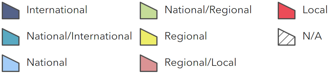
Main Beneficiaries Map
View Main Beneficiaries Map full screen in a new tab View Interactive Map HelpEcosystem service analysis
The following sections show the analysis used to determine key Ecosystem Service opportunities within the area. These opportunities have been combined with the analysis of landscape opportunities to create Statements of Environmental Opportunity. Please note that the following analysis is based upon available data and current understanding of ecosystem services. It does not represent a comprehensive local assessment. Quality and quantity of data for each service is variable locally and many of the services listed are not yet fully researched or understood. Therefore analysis and opportunities may change upon publication of further evidence and better understanding of the inter-relationship between services at a local level.
Note that numbers and figures in the body of the text are based on the 2014 profiles, unless otherwise stated.
Provisioning Services
Food provision
Assets/attributes: main contributors to service –
- Soils
- Climate – relatively high temperatures and long growing season
- Market gardening
- Dairy, sheep and pigs
- Arable
- Vineyards
- Poultry
- Fish
State – High proportion (38 per cent) of Grade 1 and 2 land in between large urban centres.
This is a fertile area which supports intensive arable farming and horticulture, with some dairy, beef and poultry. Areas of medium- quality agricultural land where soils are shallow, stony and poorly drained often support good quality permanent grassland such as on the Arun flood plain.
Fish, and particularly shellfish, are widely harvested from the harbour areas. The Selsey crab is a particular delicacy.
Main beneficiary – Regional
Analysis – The western part of the NCA falls into an area known as ‘highlight zone’ – south- facing landscape reflecting light off Solent and protected by Isle of Wight creates ideal conditions, particularly for fruit. Vineyards are increasing in popularity and there have been experiments with other more exotic crops such as olives.
County food group Hampshire Fare is a not-for-profit community interest company established in 1991, representing around 200 producers, hospitality venues, shops and cookery schools, which campaigns to heighten the awareness and consumption of Hampshire’s quality produce.
Goodwood Farm achieved full organic status in 2004, becoming the largest lowland organic farm in the UK. Milk and cream from the Dairy Shorthorn herd are processed at the farm, including being made into traditional cheeses. Produce is sold locally or used in facilities on site or during events.
During the oyster fishing season of 2007/08, 58 tons of oysters were harvested from Chichester Harbour.
Seven charter fishing boats operate within Chichester Harbour. Deterioration in water quality in the harbours would threaten this service.
Opportunities – Support safeguarding high-quality agricultural land and encourage land management practices which protect soil assets and the benefits they provide.
Manage the agricultural landscape in sustainable ways to improve soil and water regulation and improve long-term viability of agriculture and yields, protecting the natural assets of the area.
There is a need to safeguard soils and high quality agricultural land when planning development.
Crop diversity within the farming system could also be beneficial for maintaining soil quality.
Opportunities to enhance the agricultural landscape through creation of habitat mosaics where forage and nesting sites are provided for pollinators such as conservation headlands, arable field margins and wildflower mixes.
Support measures to protect and improve water quality to the harbours such as modifications to water treatment works and control of agricultural run-off through the catchment sensitive farming scheme to allow the harvesting of seafood to continue. Support sustainable harvest of native oysters.
Principal services offered by opportunities –
- Food provision
- Regulating soil quality
- Regulating water flow
- Regulating water quality
- Biodiversity
- Sense of place/inspiration
Timber provision
Assets/attributes: main contributors to service –
- Parkland
- Woodland
State – Woodland cover for this NCA is 5 per cent, covering a strong network of small and medium sized broadleaf woodlands.
Main beneficiary – Local
Analysis – This NCA is sparsely wooded and there are few suitable locations to extend woodland.
Opportunities – There are limited opportunities to improve management of broadleaf woodlands in this NCA to produce more timber.
Principal services offered by opportunities –
- Timber provision
Water availability
Assets/attributes: main contributors to service –
- Chichester aquifer
- Rivers
- Chalk streams
State – Public water supply relies upon surface water abstractions and groundwater from the Lower Greensand aquifer and the Worthing and Chichester chalk blocks.
Most of the area overlies post- Carboniferous rock, although there are small areas to the east that overlie an important chalk aquifer.
Water supply is under pressure throughout the area, with the River Meon in the west mostly classed as over-abstracted, and most of the remaining area classed as over-licensed or no water available (including the groundwater units around Portsmouth and North Hayling).
The Chichester chalk aquifer supports baseflows to spring fed rivers such as the rivers Ems and Lavant.
Main beneficiary – Regional
Analysis – The main abstractions in the Arun and West Sussex Streams are for public water supply followed by industry and agriculture while in the west, it is for public water supply followed by fish farming and watercress growth. Consequently, summer flows are naturally low.
Exploitation of the aquifer to supply potable water is seriously threatening this natural resource of chalk rivers and spring fed fens and fen-grasslands that are dependent upon the continual supply of unpolluted chalk spring water. This is likely to be an increasing problem as drought caused by climate change and increasing population put extra pressure on water supply.
Opportunities – Action to reduce demand would ease pressure on supplies that, in some case, are already fully exploited in dry years.
Encourage the incorporation of sustainable drainage systems into all new developments.
Ensure that sufficient water levels are maintained in ecologically sensitive and important streams and rivers.
Seek opportunities to restore natural river geomorphology, bringing rivers back into continuity with their flood plains and re- creating backwaters as a refuge for aquatic species in times of drought.
Encourage cultivation practices that reduce demand for water for irrigation of crops.
Principal services offered by opportunities –
- Water availability
- Regulating water quality
- Regulating soil quality
- Biodiversity
Genetic diversity
Assets/attributes: main contributors to service –
- Traditional breeds
- Local varieties
State – The Home Farm of the Goodwood Estate favours rare breeds such as Dairy Shorthorn and Sussex cattle, Southdown sheep and Tamworth and Saddleworth pigs.
Main beneficiary – Regional
Analysis – The pedigree Southdown sheep are also shown locally, continuing a tradition long held by the dukes of Richmond.
Opportunities – Opportunities exist to build on the Hampshire Fare campaign to promote more use of traditional breeds to produce high-quality produce.
Principal services offered by opportunities –
- Genetic diversity
- Food production
- Sense of history
- Sense of place/inspiration
Biomass energy
Assets/attributes: main contributors to service –
- Fertile soils
- Woodland
State – 5 per cent of the area is woodland and biomass from existing woodland sources will be limited.
Main beneficiary – Local
Analysis – Potential miscanthus yield is predominantly high as a result of the fertility of the soil, with areas of low/medium potential around Portsmouth and Chichester harbours and the urban areas to the east, while short rotation coppice yields may be restricted close to the coast due to prevailing salt laden winds.
For information on the potential landscape impacts of biomass plantings within the NCA, refer to the tables on the Natural England website.
Opportunities – There are potential opportunities for both short rotation coppice and miscanthus to be accommodated but these would need to be located appropriately within the landscape.
Principal services offered by opportunities –
- Biomass energy
Regulating Services
Climate regulation
Assets/attributes: main contributors to service –
- Soils
- Wetlands, including grazing marsh
- Woodland
State – The soils in this NCA predominantly have low levels of soil carbon (0-5 per cent). However, there are some very small patches, in the west, that reach carbon levels of up to 20-50 per cent.
2,000 ha of grazing marsh contribute significantly to carbon sequestration.
Main beneficiary – Regional
Analysis – The relatively large areas of flood plain grazing marsh have additional locked up carbon stores, as do the small areas of woodland.
Realignment schemes, such as Medmerry, can increase the extent of wetland habitats which will help compensate for the effects of climate change.
Opportunities – Where habitats are lost to coastal squeeze, compensation habitats have to be sought where natural regeneration is not possible or practical.
There is potential to increase organic matter levels on arable land.
Improvements in soil structure will also help improve water quality.
Principal services offered by opportunities –
- Climate regulation
- Regulating soil quality
- Regulating water quality
- Regulating soil erosion
Regulating coastal erosion and flooding
Assets/attributes: main contributors to service –
- Coastal vegetated shingle
- Intertidal sand and mudflats
- Coastal sand dunes
- Shingle beaches
- Hard sea defences
- Estuaries
State – A complex stretch of coastline including river estuaries and shingle beaches. Much of the coastal frontage is developed, with the major settlements including Portsmouth, Worthing and Bognor Regis.
Large lengths of this shoreline are in an unnatural form and the reclamation of extensive areas of former coastal lowland for development has produced many areas where the shoreline is artificially seaward of its natural position.
The clay headland of Selsey Bill shelters the coastline to the immediate east from the predominant south-westerly storms; sea defences are in place to protect the vulnerable cliffs from erosion.
Main beneficiary – Regional
Analysis – The relevant shoreline management plans are pursuing an overall policy of ‘holding the line’ and ‘managed realignment’ (South Downs Shoreline Management Plan, South Downs Coastal Group) such as the scheme at Medmerry which was the first of its kind on the open coast (Medmerry managed realignment scheme, Environment Agency, 2012).
Some of the coastal features are highly valued for their geodiversity and the rare plants and animals they support. Because it is highly developed, limited sections of the shoreline are free to erode naturally meaning that there is little material going into the system.
Changing climatic patterns are likely to result in increased weathering of coastal cliffs and more extreme weather events, which will test coastal defences. As a result of higher water levels ‘coastal squeeze’ will occur. This will lead to beaches, intertidal areas and amenity value being reduced or lost. This is particularly threatening to low lying tidal mudflats and salt marshes in areas of conservation importance, especially Chichester and Pagham harbours that are internationally designated as an SPA and Ramsar site, supporting bird populations that are highly dependent on the habitats provided by the intertidal areas.
An issue of special interest to local residents and boat owners in the AONB is the continued erosion of East Head.
Proposals for the medium to long-term management of East Head are contained within the Pagham to East Head Coastal Defence Strategy (Pagham to East Head Coastal Defence Strategy, Environment Agency, 2009). This is a complex problem as any major defence works would undermine the area’s character and the reasons for its nature conservation designations. The Strategy proposes a scheme of Adaptive Management that seeks to respond to change and to preserve the social, economic, environmental and amenity value of East Head for the 100-year life of the Strategy. The emphasis will not necessarily be on trying to lock the feature into its present size, shape and orientation.
Opportunities – Opportunities to create compensation habitats for those lost to ‘coastal squeeze’, aiming to ensure no net loss of habitat, benefiting biodiversity and the regulation of coastal erosion and flooding.
Ensure that realignment sites are managed to develop their full potential to support and enhance the biodiversity interest and characteristic landscape.
Principal services offered by opportunities –
- Regulating coastal erosion and flooding
- Recreation
- Biodiversity
Regulating water quality
Assets/attributes: main contributors to service –
- Rivers and chalk streams
- Estuaries
- Aquifers
- Treatment works
State – For information regarding the current state of water quality within this NCA, refer to the Environment Agency (Draft river basin management plan maps).
Main beneficiary – Regional
Analysis – The area is heavily urbanised and intensive agriculture, recreational activities and transport systems all add to pressures on water quality. These are likely to increase with further planned development and effects of climate change such as drought causing low flows and more frequent storm events leading in increased run-off.
As well as recreational sailing in the harbours, the area includes part of one of the world’s busiest shipping lanes and there are resulting problems with litter disposal as well as the constant danger of serious pollution incidents (and the ‘clean-up’ operations which follow them and may also be damaging) all of which can impact upon water quality and threaten the fragile ecology of the designated sites.
The River Arun suffers from the effects of diffuse agricultural pollution largely arising in the wider catchment outside this NCA, forming part of the Arun and Western Rother Defra Priority Catchment. Equally the River Meon and the catchments of Chichester and Pagham harbours are vulnerable to diffuse agricultural pollution arising from outside the NCA. This is of particular concern given the international designations of these harbours as SPAs.
Many of the rivers are heavily modified.
In 2008, a £29m nitrogen removal scheme to improve the quality of the treated wastewater returned to the environment at Peel Common was completed.
Serious concerns have been raised at the ability of waste water treatment facilities to cope with current and future housing development.
The quality of water in Chichester Harbour is not statutorily assessed as bathing water and is not therefore monitored in accordance with the EC Bathing Water Directive by the regulator. However, the discharge of sewage into the Harbour may have environmental health implications particularly for people enjoying activities on the water such as sailing and kayaking.
There have been a number of efforts to improve water quality in this area including Portsmouth Water’s Downs and Harbours Clean Water Partnership.
The Arun and Rother Connections project (ARC), is a HLF funded project to improve water quality and flow in the catchments and encourage local people to appreciate the services provided by their river. It involves major works to ease fish passage, river and chalk stream restoration, surveys and removal of non-native invasive aquatic plant species, wetland habitat restoration (fen, reedbed, species rich flood plain meadow and wet woodland) and heath restoration as well as engaging communities and landowners and improving access and interpretation.
Opportunities – Work with water companies to investigate and implement innovative solutions to point source pollution and untreated waste water.
Consider reviewing ecological designations for the area’s chalk streams.
Work with partners to expand areas of semi-natural habitat in chalk stream flood plains, within the NCA and upstream, to act as pollution filtration.
Provide information about chalk stream ecology and the negative impacts of unsustainable water use.
Reduce the amount of nutrients entering the harbours from domestic and industrial sources by engaging with the planning process to ensure that new developments incorporate the best possible measures for reducing problems from waste, including sustainable drainage systems (SuDS).
Promote the installation of holding tanks for recreational vessels and seek to provide the necessary infrastructure to pump out holding tanks. Ensure adequate reception facilities for vessel landed waste and maintain a Maritime and Coastguard Agency-compliant Port Waste Management Plan.
Increase the amount of farmland in and upstream of this NCA managed under principles established by the Catchment Sensitive Farming Programme or its water company equivalent.
Buffer watercourses with semi-natural vegetation – permanent grassland, scrub, woodland – to intercept diffuse pollution by sediment run-off and nutrients, particularly upstream beyond the borders of the NCA.
Seek opportunities to restore natural river geomorphology, bringing rivers back into continuity with their flood plains.
Expand and link lowland meadows, flood plain grazing marsh and other wetland habitats found on the flood plains of the rivers and chalk streams.
Work with the Solent Water Quality Association and other partners to achieve the highest water quality and achieve the aims of the Water Framework Directive.
Control the amount of nutrients entering the harbours from agricultural sources by encouraging catchment initiatives that engage and challenge farmers to reduce nutrient leaching, pesticide contamination and soil erosion.
Principal services offered by opportunities –
- Regulating water quality
- Regulating soil quality
- Regulating soil erosion
- Biodiversity
- Recreation
Regulating water flow
Assets/attributes: main contributors to service –
- Rivers
- Flood plains
- Wetland
- Harbours
- Coast
State – The Arun has a wide flood plain with slow river flows, although much of this flood storage capacity has been lost through drainage of marshlands and conversion to intensive agriculture both within and upstream of this NCA.
The Meon runs over chalk, rainfall soaks into the ground here instead of running off into the river. A tidal sluice on the Lower Meon maintains the freshwater marsh of Titchfield Haven, with storage of water identified as being important to both long-term flood alleviation and wetland conservation.
There are also several chalk fed streams that run in this NCA such as the Lavant and the Bosham stream. Settlements within the NCA, such as Arundel and Littlehampton, are protected by flood banks. The River Lavant has a long history of flooding in Chichester.
Main beneficiary – Regional
Analysis – Significant flood events have occurred several times in the last 40 years in the Arun and Western streams catchments and river banks need repair and maintenance. The River Lavant Flood Alleviation Scheme is designed to divert flows away from Chichester and then safely discharge them into Pagham Harbour.
Policies to reduce flood risk in Worthing, Shoreham and Brighton include the storage of water within the Adur catchment on
the South Downs (outside this NCA) and encouraging the adoption of Sustainable Urban Drainage Systems.
Major dredging work has begun in Portsmouth Harbour to enable it to accommodate new 65,000-tonne aircraft carriers.
Opportunities – Explore and where appropriate implement water retention measures to help maintain water levels in rivers during periods of drought.
Seek opportunities to restore natural river geomorphology, bringing rivers back into continuity with their flood plains and re- creating backwaters as a refuge for aquatic species in times of drought.
Incorporate sustainable drainage systems (SuDS) in all new development, including features such as porous surfaces, swales, green roofs and more green space.
Plan for and manage for the effects of coastal change by allowing the operation of natural coastal processes and the creation of new habitats to reduce flooding to built- up areas.
Ensure that realignments are managed so that intertidal habitats can develop and expand effectively.
Principal services offered by opportunities –
- Regulating water flow
- Regulating water quality
- Biodiversity
Regulating soil quality
Assets/attributes: main contributors to service –
- Soils
- Rivers
- Coastal salt marshes
- Harbours
State – High proportion (38 per cent) of Grade 1 and 2 land in between large urban centres.
There are nine main soilscape types in this NCA:
- Freely draining slightly acid loamy soils, covering 43 per cent of the NCA.
- Loamy soils with naturally high groundwater (33 per cent).
- Loamy and clayey soils of coastal flats with naturally high groundwater (7 per cent).
- Slowly permeable seasonally wet slightly acid but base-rich loamy and clayey soils (7 per cent)
- Loamy and clayey flood plain soils with naturally high groundwater (2 per cent).
- Shallow lime-rich soils over chalk or limestone (1 per cent).
- Sand dune soils (1 per cent).
- Freely draining slightly acid but base-rich soils (1 per cent).
- Freely draining very acid sandy and loamy soils (1 per cent).
Main beneficiary – Regional
Analysis – The freely draining slightly acid loamy soils may be valuable for aquifer recharge, requiring the maintenance of good structural conditions to aid water infiltration and requiring the matching of nutrients to needs to prevent pollution of the underlying aquifer.
The loamy soils with naturally high groundwater have a low bearing strength where groundwater remains high and are therefore at increased risk of soil compaction from mechanised operations, stock grazing or recreational use in wetter conditions.
Diffuse pollution (such as from applied manures and very fine sediments) is also possible as a result of run-off due to persistently high groundwater levels or from local flooding. Both of these soils may have potential, especially under arable cropping, for increased organic matter levels through management interventions.
The large urban centres and transport links surrounding agricultural land mean that pollution of soils via run-off from roads is a constant problem.
Maintaining quality of soils will help safeguard future yields and wider ecosystem service provision
Opportunities – Continue to apply the principles and best practices employed through initiatives such as Catchment Sensitive Farming.
Identify areas where soils are most at risk of damage from cultivation and work with landowners and farmers to adopt sensitive soil management practices as appropriate.
Work to improve treatment of waste water and prevent run-off from roads by promoting measures such as extending verges and hedgerows.
Maintain salt marsh and other intertidal habitats as a buffer between the sea and agricultural land and to protect against saline intrusion.
Seek to keep the highest quality soils in agricultural production.
Principal services offered by opportunities –
- Regulating soil quality
- Food provision
- Regulating soil erosion
- Biodiversity
- Regulating water quality
Regulating soil erosion
Assets/attributes: main contributors to service –
- Soils
- Rivers
State – The River Arun forms part of the Arun and Western Rother Defra Priority Catchment under the England Catchment Sensitive farming and suffers from sedimentation largely as a result of soil erosion higher in the catchment outside this NCA.
Many parts of the area are susceptible to flooding.
Main beneficiary – Local
Analysis – The lighter soils make up just under half of the NCA (dominated by freely draining slightly acid loams), and have enhanced risk of soil erosion on moderately or steeply sloping land where cultivated or bare soil is exposed, often exacerbated where organic matter levels are low after continuous arable cultivation or where soils are compacted.
There is also the potential for wind erosion on some coarse textured cultivated variants of the freely draining slightly acid loams. Sand dune soils are very droughty and unstable, with the extent of erosion depending on the degree to which vegetation has stabilised the dune system.
A few of the component soils of the freely draining base-rich soils (just 1 per cent of the NCA) may be susceptible to capping and slaking, increasing the risk of soil erosion, and these soils need to be managed carefully to reduce risks with careful timing of cultivations and maintenance of vegetation cover. The remaining soils have a low risk of soil erosion, except where coarser textured variants of loamy soils with naturally high groundwater occur on sloping or uneven ground.
The light soils of the coastal plain may be susceptible to wind erosion in the future under climate change.
Coastal flooding can damage soils and cause erosion.
Opportunities – Continue to apply and extend the reach of tried and tested techniques for reducing soil erosion resulting from agriculture that are being promoted among the farming community by projects such as Catchment Sensitive Farming.
Opportunity to create areas of semi-natural habitat and low-input grasslands (including grassland buffer strips) to minimise soil compaction, allow dense vegetation to improve water retention to minimise soil run-off and improve water quality.
Promote the retention of mudflats, coastal salt marshes and sand dunes to provide a cost effective defence against soil erosion and prevent saline intrusion from damaging soils.
Principal services offered by opportunities –
- Regulating soil erosion
- Regulating water quality
- Regulating soil quality
- Regulating water flow
Pollination
Assets/attributes: main contributors to service –
- Grassland parks and gardens
- Hedges
- Heathland
State – With nearly 2,000 ha of grassland, this area provides important sources of nectar for pollinating insects. Gardens and allotments within urban areas also provide food sources for pollinating insects.
Main beneficiary – Regional
Analysis – In a productive agricultural area, including soft fruit, pollinators are critical for the future of insect dependent crops and increases in this service may be required in order to provide greater options for future cropping.
This service could be increased by restoration of wetland habitats, and the creation of conservation headlands and arable field margins. This could have a beneficial impact on biodiversity by linking habitats and creating network of habitats in close proximity
Opportunities – Opportunities to enhance the agricultural landscape through creation of habitat mosaics where forage and nesting sites are provided for pollinators such as conservation headlands, arable field margins and wildflower mixes providing additional environmental benefits.
Seek opportunities to increase field margins, species-rich hedgerows and beetle banks to encourage a network of habitats and food sources for pollinating insects close to areas of agricultural production.
Principal services offered by opportunities –
- Pollination
- Food production
- Biodiversity
Pest regulation
Assets/attributes: main contributors to service –
- Grassland
- Wetland
- Woods
- Rivers
- Field margins
- Parks and gardens
State – The semi-natural habitats adjacent to arable farmland support populations of pest regulating invertebrate, bird and mammal species.
Main beneficiary – Local
Analysis – This service could be increased by restoration of wetland habitats, verges, conservation headlands and arable field margins creating connecting networks of habitats.
Opportunities – Opportunities for a landscape scale approach which provides the necessary connectivity and extent of habitats to sustain populations of predators and enable them to move between sites.
Manage semi-natural habitats to increase diversity of structure and composition and increase populations of pest-regulating species.
Seek opportunities to increase field margins, species-rich hedgerows and beetle banks to encourage a network of habitats for pest regulating species close to areas of agricultural production.
Principal services offered by opportunities –
- Pest regulation
- Food production
- Biodiversity
Cultural Services
Sense of place/inspiration
Assets/attributes: main contributors to service –
- Coastal landscape
- Harbours
- Views of Isle of Wight and the South Downs
State – Sense of place is provided by the sea and intricately indented shoreline of the exposed coastal landscape, and notably the natural harbours of Chichester and Pagham. Across the Solent, the Isle of Wight forms a distinctive backdrop.
There are also a few surviving traditional settlements displaying a unifying local vernacular of timber frame, flint, cob and thatch. This is further supported by the pattern of large rectilinear fields enclosed by drainage ditches, remnant tracts of valley meadow and coastal heath.
Main beneficiary – Regional
Analysis – In such an urban area, sense of place is achieved primarily by views of the sea, which are possible from most places within the NCA. Eric Coates was inspired to write ‘Sleepy Lagoon’, the theme tune for Desert Island Discs, while watching the sea from Selsey.
Portsmouth, with its importance as a major route to the continent and military connections, was a frequent inspiration to artists and writers during the 19th century. In Jane Austen’s novel Mansfield Park, Portsmouth is the hometown of the main character Fanny Price, Dickens’ Nicholas Nickleby joins a theatre troupe in the town and Gilbert and Sullivan’s HMS Pinafore is set in the harbour. Oscar Wilde wrote The Importance of Being Earnest during a visit to Worthing.
Spinnaker Tower is a 170-metre tower opened in 2005 as part of the redevelopment of Portsmouth harbour. It is visible from miles around and affords 360-degree views of the surrounding area, including from the Manhood Peninsula and Isle of Wight.
Opportunities – Encourage a strategic approach to the planning of land use around Chichester and Langstone harbours and the Manhood Peninsula to address the pressures of climate change and development, ensuring that natural processes continue to function and the comparatively wild and tranquil character is retained.
Ensure that realignment sites are managed to develop their full potential to support and enhance the characteristic landscape.
Principal services offered by opportunities –
- Sense of place/inspiration
- Tranquillity
- Sense of history
- Biodiversity
Sense of history
Assets/attributes: main contributors to service –
- Roman sites
- Historic buildings
- Naval defences
- Harbour settlements
- Traditional buildings
- Parkland
State – Several important Roman sites and medieval buildings.
Small flint villages, isolated dwellings and farm buildings.
Military sites and structures from all periods.
About 68 per cent of historic farm buildings remain unconverted. About 93 per cent are intact structurally.
The Heritage Lottery Funded 2004 Archaeological Research Framework and accompanying 2007 research synthesis provide a comprehensive baseline of the archaeological resource of the AONB.
There are 10 registered parks and gardens within the NCA covering 427 ha.
Main beneficiary – Interational
Analysis – Archaeological and historical features include Roman villa sites such as Fishbourne Roman Palace, Chichester cathedral set within the historic city of Chichester and a post-medieval abbey at Titchfield. Picturesque harbourside settlements such as Bosham and isolated hamlets in rural areas provide additional historic context. There are also numerous historic naval associations at Portsmouth including Napoleonic fortifications such as the distinctive line of round Napoleonic forts that march out across the Solent guarding its eastern entrance and the entrance to Portsmouth Harbour, locally known as Palmerston’s Follies.
The area also has strong associations with aerial combat, with Goodwood Aerodrome, Shoreham Airport and Lee-on-Solent still operational. The former First World War, Second World War and Cold War airfield at Tangmere now houses an aviation museum. Displays include the aircraft in which world air speed records were achieved in 1946 and 1953 along the coast at Littlehampton. Shoreham is the oldest licensed airfield in the UK and has a Grade II* listed Art Deco style terminal building.
The rich arable lands combined with access to local urban markets and London allowed many farmers to re-build their farmsteads, particularly in the 18th and 19th centuries. This re-building means that there are very few pre-1750 farm buildings.
Buildings for cattle are predominantly 19th century. Earlier cattle buildings would be considered important.
Traditional building materials are of timber frame, flint, cob and thatch that all contribute to the area’s sense of place. Many villages have retained their attractive medieval and late medieval core.
A number of historic settlements and heritage assets now subsumed into the larger conurbation are considered at risk of losing their identity and historical context.
The HLF programme developed a strong archaeology partnership through a steering group that continues to oversee research within the AONB which informs engagement with local schools, visitors, landowners and residents within the AONB to help develop a wider understanding and appreciation of the historical value.
Opportunities – Opportunities should be sought to enhance the setting, interpretation and condition of the remaining assets.
The restoration and conversion of vernacular buildings should be sympathetic to local distinctiveness and use local materials where possible.
Encourage partners to use the results of the Archaeological Framework when prioritising and commissioning research both within and around the AONB, to guide the management of the historic environment.
Encourage and support communities to seek funding to develop local heritage projects and initiatives.
Encourage interpretation to improve understanding of the area’s heritage including internationally recognised assets such as Portsmouth historic dockyard, Fishbourne Roman Villa and Chichester Cathedral. Support initiatives to improve sustainable transport links between these sites.
Principal services offered by opportunities –
- Sense of history
- Recreation
- Sense of place/inspiration
Tranquility
Assets/attributes: main contributors to service –
- Harbours
- Coastline
- Woodland
State – Only 7 per cent of the area is classed as undisturbed, down from 28 per cent in the 1960s; 35 per cent of the area is classified as urban.
The main areas of low level tranquillity are around the major towns – Portsmouth, Chichester, Fareham, Bognor Regis and Worthing and along road corridors such as the A27, M27 and the M275
Main beneficiary – Local
Analysis – Tranquillity is a scarce resource within this heavily urbanised NCA. Pockets of tranquillity are associated with the central rural areas and undeveloped harbours, including parts of Chichester Harbour. Tranquillity is also associated with the edges of remoter ancient woodlands at the foothills of the South Downs.
Opportunities – Encourage a strategic approach to the planning of land use around Chichester and Langstone harbours and the Manhood Peninsula to address the pressures of climate change and development, ensuring that natural processes continue to function and the comparatively wild and tranquil character is retained.
Principal services offered by opportunities –
- Tranquillity
- Sense of place/inspiration
- Biodiversity
Recreation
Assets/attributes: main contributors to service –
- Coastline
- Harbours
- Rights of way
- Open access land
- One National Nature Reserve (NNR)
- Parks and gardens
- Historic attractions
- Wildlife
State – Recreation is dominated by the seaside resorts of the urban east (such as Worthing and Bognor Regis) as well as the caravan parks, ribbon development and harbourside tourism that characterise much of the rest of the coast. There is a 670 km rights of way network at a density of 1.29 km per km² and 230 ha of open access land, covering 0.45 per cent of the NCA.
Titchfield Haven NNR is managed by Hampshire County Council.
Water-borne recreation is popular in this NCA. Chichester Harbour with 28 km2 of water, 27 km of well marked and lit channels and with easy access to the Solent is an ideal water recreation centre. The Harbour has over 5,200 moorings and marina berths, and 16 sailing clubs.
Chichester Harbour AONB has approximately 1.5 million people visiting each year.
The internationally designated wildlife sites make this a popular area for birdwatching.
In response to concerns over the impact of recreational pressure on birds within protected areas in the Solent, the Solent Disturbance and Mitigation Project was initiated to determine visitor access patterns around the coast and how their activities may influence the birds.
Main beneficiary – National
Analysis – With a low beach gradient and the lack of any obvious dangers such as rips or obstacles, East Wittering and the whole stretch of Bracklesham Bay is a favourite with surfers with one of the UK’s longest running surf clubs, Shore Surf Club, founded in 1969.
Most of the coastal footpath network is located along existing sea defences, embankments or the foreshore itself. Should significant changes appear likely, options will need to be sought to relocate footpaths and other recreational resources inland.
Popular birdwatching areas outside the internationally designated sites include Titchfield Haven, which has a network of accessible routes and a hide.
Chichester Harbour AONB is one of the most important areas for water recreation in the country. There is considerable congestion and overcrowding on the water, particularly at weekends in the summer and conflict between different types of harbour user. Chichester Canal is currently under-used.
Walkers, cyclists, artists and birdwatchers are among those who enjoy Chichester Harbour AONB. There are strong indications that the number of visitors will continue to increase. Continuing development within and adjacent to the AONB is likely to lead to increased population pressure. Visitor impact needs to be monitored and addressed to minimise the effect on the very resource people come to enjoy.
Much work has already been undertaken by Chichester Harbour Conservancy in association with Action in Rural Sussex, Age Concern and other local organisations to further the work of the Local Strategic Partnership group to reduce isolation among older people.
Goodwood Estate runs an extensive education programme including forest schools and hands- on sessions at its farm.
The peregrine falcon nest on the spire of Chichester Cathedral is widely viewed via a webcam each spring and receives great attention from local and national media.
The Solent Disturbance and Mitigation Project (SDMP) provides evidence that recreational pressures from new development within 5.6 km of the Solent coastline may have an adverse affect on internationally protected birds.
Opportunities – Secure the long-term future of the coastal footpaths, investigating managed realignment and permissive route options where possible. Develop a strategy for managing those at risk from rising sea levels and failing sea defences.
Support the provision of a high-quality network of footpaths, cycle routes and wheelchair paths through the Rights of Way Improvement Plans and other initiatives.
Promote the Solent Disturbance Mitigation Project as a basis for formulating coherent policies for minimising impact of increased development and recreation provision on internationally important bird populations.
Work with partners to educate groups using the water bodies on the needs of others and to give guidance on behaviour and good practice and balance the demand for more and improved boating facilities with environmental considerations. Support changes which encourage users to enjoy congested areas such as Chichester Harbour outside peak times.
Support the work of partners including Chichester Harbour Conservancy and Environmental Education Groups to establish closer links between the harbour education service and the local farming community, sustainable schools and healthy eating programmes and community services.
Ensure that realignment sites are managed to develop their full potential to support and enhance access and interpretation where appropriate.
Work with partners to develop a plan for avoidance and mitigation to minimise impact of recreational activities on internationally protected bird population.
Support the use of Chichester Canal to link Chichester to the AONB through the Chichester Canal Trust.
Principal services offered by opportunities –
- Recreation
- Sense of place/inspiration
- Sense of history
- Biodiversity
Biodiversity
Assets/attributes: main contributors to service –
- Internationally designated sites
- SSSI
- One NNR
- Coastal habitats
- Grazing marsh
- Heathlands
- Meadows
- Woodlands
- Gardens
State – Some 3 per cent (1,700 ha) of the area is designated as Site of Special Scientific Interest (SSSI) and there are four Special Protection Areas (SPAs), two Special Areas of Conservation (SAC) and four Ramsar sites.
The marine environment of Chichester Harbour AONB is afforded protection through the Solent Maritime SAC European designation.
Horsea Island is one of the sites chosen by Butterfly Conservation for trials of disease resistant elms for the benefit of white-letter hairstreak butterfly since 2000.
Relatively small fragments of coastal grazing marsh occur, with larger areas at Farlington Marshes and the marshes on the eastern side of Hayling Island.
Heathland is no longer a significant habitat within the area, although pockets such as Hamble Common survive.
European native oyster populations have experienced an acute decline since the 19th century due to the combination of over- fishing and associated habitat loss, combined with the anthropogenic and environmental pressures of pollution, disease and the presence of non-native species.
Main beneficiary – International
Analysis – Chichester Harbour has been designated as a wetland of international importance under the Ramsar Convention (1971) as it regularly holds 20,000 or more wildfowl and waders in winter, has the third largest population of dark-bellied Brent geese in the country (with Pagham, Langstone and Portsmouth harbours also in the top 12) and has internationally significant populations of Dunlin and black-tailed godwit. It is also an important site for nesting terns. A subtidal survey of habitats and species within the harbour identified 200 maritime taxa including invertebrates, algae and fish. There is also a colony of harbour seals and water voles are regularly seen.
In recent years Chichester Harbour has not regularly supported significant numbers of breeding terns, probably due to a combination of disturbance and erosion of historical breeding sites. However, the NCA as a whole is important for breeding terns.
Between Shoreham and Bognor Regis the coastline supports fringing shingle beaches where pioneer plant communities survive in places. These contain characteristic plants such as yellow-horned poppy and sea kale as well as rarities such as starry clover.
The relict dunes at Bognor Reef support the nationally rare childing pink, as does Pagham Beach where the long-winged conehead, sand dart and Matthew’s wainscot moth can also be found.
The Hampshire Wildlife Trust reserve at Farlington Marshes and the marshes on the eastern side of Hayling Island provide some more extensive and well developed examples of coastal grazing marsh.
Historically heathland was much more extensive, linking with the hunting forests of Bere and Waltham Chase in south Hampshire so there may be opportunities to extend or re-create small areas.
There is increasing concern at the disturbance caused to nature conservation interests by increased recreational pressure from housing development.
IFCA identified 22 species of fish within Chichester Harbour. A survey carried out in 2004 by the University of Portsmouth recorded 32 species, with sand and painted gobies and black bream the most abundant. Also numerous at some sites were bass, ballan wrasse and corkwing wrasse. Several species, such as the bass, bream, mullet, sole and plaice use the harbour as a nursery area with a large percentage of juveniles making up the survey samples ( Farrell, 2005, A survey of the fish population of Chichester Harbour, University of Portsmouth).
The Solent oyster population has declined in the last decade and shows no sign of broad scale recovery. The Chichester oysters are considered to be a component of this wider population. The native oyster fishery has been locally important in Chichester Harbour since at least Roman times.
Closer scrutiny of the impact of activities, such as oyster dredging and bait digging, on the subtidal and intertidal biodiversity within the AONB may be required in future to determine the impact on favourable conservation status.
Opportunities – Ensure that realignments are managed so that intertidal habitats can develop and expand effectively.
Where existing flood defences are reinforced, work with partners to limit adverse impacts on biodiversity.
Improve water quality by reducing the amount of nutrients entering the harbours from domestic and industrial sources by engaging with the planning process to ensure that new developments incorporate the best possible measures for reducing problems from waste, including SUDS.
Improve water quality by reducing the amount of nutrients entering the harbours from agricultural sources by continuing with catchment initiatives that engage and challenge farmers to reduce nutrient leaching, pesticide contamination and soil erosion.
Seek to secure the future of breeding terns (particularly Little Terns) in the harbours.
There are opportunities to extend and possibly link areas of coastal grazing marsh as part of flood defence measures.
Preserve scarce areas of heathland and seek opportunities to improve and extend.
Support inclusion of high-quality greenspace within new and extended development for the wellbeing of local communities and to provide links between important biodiversity sites.
Support the Sussex Sea Fisheries Committee in maintaining the bass nursery area.
Support management of native oysters in Chichester Harbour, including implementation of temporary closure of fisheries to allow populations to recover when necessary.
Support the bait digging Code of Conduct and work within the SEMS Management Scheme to monitor the level and impact of bait digging.
Principal services offered by opportunities –
- Biodiversity
- Food production
- Regulating water quality
- Regulating water flow
- Regulating coastal erosion and flooding
- Recreation
- Sense of place/inspiration
Geodiversity
Assets/attributes: main contributors to service –
- Upper raised beach deposits
- Coastal exposures
State – Remains of Homo heidelbergensis were first found at Boxgrove in 1994, comprising the partial tibia of a male. In 1996 two incisor teeth from another individual were found. In 2003 English Heritage announced it would buy the remains of the quarry to ensure the preservation of the site complex.
Main beneficiary – International
Analysis – Boxgrove is a site of national archaeological importance because of the discovery in 1994 and 1995 of 500,000 year old human fossils of a nomadic hunter-gatherer (‘Boxgrove Man’ and associated artefacts), found in the gravel deposits of a raised beach which remain the oldest such fossils ever discovered in the UK. There were also animal bones which are the oldest found specimens of their species, such as the wing bone of the great auk found at the site in 1989.
The coastal exposures of Lower Tertiary deposits reveal diverse fossil assemblages, such as at Felpham, Bognor Reef and Bracklesham Bay.
Selsey is a key Quaternary site for a sequence of freshwater and estuarine deposits of Ipswichian Interglacial age. Mammal remains including rhinoceros, horse and hippopotamus have also been recorded from the deposits. Much potential exists for vertebrate research at this locality, particularly with regard to stratigraphy and pollen zonation.
East of Langstone a low cliff line at high water mark exhibits a complex of Brickearth and Coombe Rock deposits and at East Head there is a sizeable sand dune and shingle system both of which are of geomorphological importance.
Pagham Harbour is a key site for coastal geomorphology and also has an outstanding palaeobotanical site of great importance to studies of Tertiary floras.
Generally a good place to study coastal processes at work.
Opportunities – Interpret and promote the Boxgrove site to encourage interest and understanding of the area’s geodiversity.
Maintain coastal exposures of Lower Tertiary deposits revealing diverse fossil assemblages, such as at Felpham, Bognor Reef and Bracklesham Bay.
Maintain important inland geology exposed in pits and quarries, such as Downend Chalk Pit SSSI, helping to promote an appreciation and understanding of the geodiversity of the NCA and connecting communities with their local heritage.
Conserve coastal geomorphological features (and the natural processes needed to sustain them) including sand dune systems, sand and shingle spits and banks (for example East Head).
Encourage the use of traditional building materials in conservation projects (for example timber frame, flint, cob and thatch) and promoting the use of the Chichester Harbour AONB Design Guidance for replacement dwellings in the AONB.
Continue to research, monitor and record geomorphological processes to inform management decisions.
Provide access to sites of geological interest where appropriate and interpret the geological features and dynamic coastal processes to improve understanding and appreciation.
Encourage research, monitoring and recording of geomorphological processes.
Principal services offered by opportunities –
- Geodiversity
- Recreation
- Sense of place/inspiration
- Sense of history