

National Character Area 57
Sefton Coast - Analysis: Ecosystem Services
Analysis supporting Statements of Environmental Opportunity
The following analysis section focuses on a selection of the key provisioning, regulating and cultural ecosystem goods and services for this NCA. These are underpinned by supporting services such as photosynthesis, nutrient cycling, soil formation and evapo-transpiration. Supporting services perform an essential role in ensuring the availability of all ecosystem services.
Bodiversity and geodiversity are crucial in supporting the full range of ecosystem services provided by this landscape. Wildlife and geologically-rich landscapes are also of cultural value and are included in this section of the analysis. This analysis shows the projected impact of Statements of Environmental Opportunity on the value of nominated ecosystem services within this landscape.
Further analysis on landscape attributes and opportunities for this NCA is contained in the Analysis: Landscape Attributes & Opportunities section.
Natural Capital
Further information on Natural Capital within this NCA is contained in the Natural Capital and Key Ecosystem Services section.
The Sefton Coast NCA provides a wide range of benefits to society. Each is derived from the attributes and processes (both natural and cultural features) within the area. These benefits are realised through the ‘ecosystem services’ that flow from the ‘ecosystem assets’ or ‘natural capital’ of a place.
Natural capital means ‘the elements of nature that directly or indirectly produce value to people, including ecosystems, species, freshwater, land, minerals, the air and oceans, as well as natural processes and functions’ (Natural Capital Committee, 2017).
Ecosystem Services Main Beneficiaries
The below map displays the main beneficiaries of each ecosystem service identified within this NCA and neighbouring NCAs. These range from being of international importance to local importance. Some services have not been assessed within all NCAs, and therefore in some NCAs are displayed as “N/A” (not applicable).
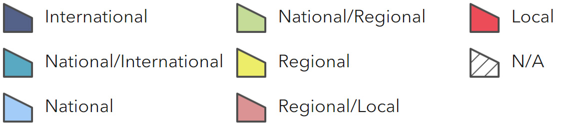
Main Beneficiaries Map
View Main Beneficiaries Map full screen in a new tab View Interactive Map HelpEcosystem service analysis
The following sections show the analysis used to determine key Ecosystem Service opportunities within the area. These opportunities have been combined with the analysis of landscape opportunities to create Statements of Environmental Opportunity. Please note that the following analysis is based upon available data and current understanding of ecosystem services. It does not represent a comprehensive local assessment. Quality and quantity of data for each service is variable locally and many of the services listed are not yet fully researched or understood. Therefore analysis and opportunities may change upon publication of further evidence and better understanding of the inter-relationship between services at a local level.
Note that numbers and figures in the body of the text are based on the 2014 profiles, unless otherwise stated.
Provisioning Services
Food provision
Assets/attributes: main contributors to service –
- Agricultural land
- Soils
- Grasslands and grazing marsh
- Tidal waters and intertidal habitats supporting shellfish populations
State – 9 per cent (as a proportion of the total land area) is Grade 1 agricultural land (837 ha), with another 16 per cent Grade 2 (1,470 ha), giving rise to productive cropping, including horticultural produce.
Holdings are predominantly split between general cropping (33 per cent of the total farmed area), lowland grazing livestock, mainly cattle (17 per cent) and ‘other’ types (30 per cent) (‘other’ includes horse grazing).
There are also low numbers of cereal, horticulture and specialist pig holdings.
A complex land drainage network has been created in the coastal hinterland to support agricultural production.
Some agricultural land is extensively used by wildfowl and waders for roosting and feeding.
The very sandy soils along the coast are internationally and nationally recognised as important nature conservation sites and tend to be in non-agricultural uses. Grazing is used for habitat management in some areas.
Around Formby, the sandy soils suit a small area of very specialist production of asparagus.
A number of commercial fisheries operate within Liverpool Bay.
Main beneficiary – Regional
Analysis – Agriculture is an important element of land management.
Potential for increasing food production is likely to be limited, with issues around land drainage and soil erosion. While intensive drainage provides short-term productivity benefits, the longer term impact on ground levels and associated drainage impairment will reduce the effectiveness of the drainage system and may reduce agricultural productivity overall.
The expectation is that climate change will result in a greater variability in rainfall through the year, with wetter winters and drier summers predicted. This will place further challenges on the existing systems (Lower Alt with Crossens Pumped Drainage Catchment Draft Flood Risk Management Strategic Plan: Consultation Document, Environment Agency).
Agricultural practices in the hinterland can affect the nature and wildlife of the coast. In a climate of changing farming practices there may be opportunities to work with farmers to manage change, such as establishing wetland areas.
The former growing of asparagus, which was cultivated in small fields or ‘pieces’ enclosed by fences of scrap timber and driftwood, has created a unique landscape.
Common or brown shrimp are caught in a number of shallow waters, including in the Penfold Channel off Southport and in Formby Pool. The shrimp fisheries are carried out at different intensity, varying from trawls and push nets, to tractor-towed nets. When shrimps are out of season, cockles and mussels are sometimes gathered by hand, such as at Blundellsands and Formby.
Inshore trawlers also take a variety of white fish from further offshore. Trawlers often fish off the Sefton Coast in the main white fishing grounds, north of Taylor’s Bank, offshore from Ainsdale.
Opportunities – Work with the farming community to encourage sustainable agricultural practice, while delivering other benefits such as maintaining soil and water quality, managing flood risk, providing habitats for wildlife and recreational benefits.
Encourage agricultural practices that reduce diffuse pollution and eutrophication.
Interpret long established land uses such as asparagus farming.
Work with the local fishing community to promote sustainable fishing practices.
Promote sensitive bait digging and shellfish gathering practices to maintain sustainable fisheries, while minimising disturbance to important waterfowl populations.
Principal services offered by opportunities –
- Food provision
- Water availability
- Regulating water quality
- Regulating water flow
- Regulating soil quality
- Regulating soil erosion
- Sense of history
- Biodiversity
Timber provision
Assets/attributes: main contributors to service –
- Woodland cover
- Plantation woodland
- Mersey Community Forest
State – Woodland cover is nearly 8 per cent of the NCA including 262 ha broadleaf woodland, 307 ha coniferous woodland, 47 ha mixed woodland.
There are large conifer plantations around Formby. Plantation woodland was introduced into the landscape by local estate owners from the 18th century. The main woodland species is Corsican pine.
The Mersey Community Forest covers 90 per cent of the area.
Main beneficiary – Local
Analysis – The conifer plantations are similar in age, so that they are now all moving simultaneously towards the end of their lifespan. They provide habitat for red squirrel, so that their renewal needs to be carefully managed.
Continued coastal sand dune erosion at Formby Point is occurring. The natural landward movement of habitats in response to coastal change is constrained. Wind and sand blow affect the woodland edge along the coast. Some open areas are important for pink-footed goose feeding. This limits potential for increased timber production.
Sefton Coast Woodlands Forest Plan sets out to take a joined-up approach to the management of the areas woodlands, including sustainable management of the woodlands, red squirrel conservation and supporting recreation and tourism.
The woodlands have generated sustainable wood products and provide training opportunities.
Opportunities – Encourage the appropriate management of woodland, diversifying age structure of woodlands, to provide multiple benefits including timber provision, red squirrel conservation and recreation.
Principal services offered by opportunities –
- Timber provision
- Biomass energy
- Sense of place/inspiration
- Sense of history
- Recreation
- Biodiversity
Water availability
Assets/attributes: main contributors to service –
- Semi-natural habitats
- Rivers Alt and Crossens
- Rainfall Dune aquifer
State – The Alt Crossens catchment drains low-lying land between the Ribble and Mersey estuaries.
Within the Crossens area, the majority of surface water and some of the groundwater abstraction are for agriculture (Ribble, Douglas and Crossens abstraction licensing strategy, Environment Agency, 2013). The Crossens supports a coarse fishery.
Water is abstracted in the Alt catchment from both surface and groundwater sources, for a variety of purposes including public and private water supply, spray irrigation, industry and golf courses (Lower Mersey and Alt abstraction licensing strategy, Environment Agency, 2013).
The Alt and Crossens catchments also support a population of water vole.
The sand dunes are a minor aquifer and dune water level is dependent on rainfall. There are some abstractions from the dune aquifer, for example for the golf courses. The natural groundwater reservoir is an essential element of the dune ecosystem, with several habitats and species dependant on natural fluctuations in water levels
Main beneficiary – Local
Analysis – The network of pumping stations manages land drainage for agriculture while maintaining higher water levels during summer months to provide water for irrigation of the agricultural crops grown in the area.
Climate change predictions show that pressure on water resources is likely to increase in the future.
The dune water table can be reduced by abstraction, drainage, coastal erosion, and trees and shrubs which intercept a proportion of the rainfall. Water quality, quantity and seasonal fluctuations are all important in maintaining habitats such as dune slacks. Natural fluctuation in the dune water table contributes to dynamic dune processes such as the formation of blow outs and wet slacks. In the long-term climate change may result in a lowering of the water table and this would have implications for the current dune slack system.
Opportunities – Ensure the land drainage network is managed in an environmentally sustainable manner.
Work with farmers and land managers to manage demand for water, promoting the sustainable use of water in terms of water use and water conservation.
Seek opportunities to create water storage areas, which will also increase semi-natural habitats.
Encourage farmers to use best practice in soil management, in order to increase infiltration rates and water-holding capacity and slow run off using techniques such as minimum tillage and controlled farm traffic to protect soil structure.
Ensure that plans are in place to adapt water supply systems to expected climate change.
Maintain the natural functioning of the dune aquifer to support characteristic sand dune habitats. Monitor water levels in the dune system to improve understanding of the dune aquifer and the effects of water abstraction. Protect groundwater levels in sensitive areas by controlling and monitoring abstraction licences. Work with land managers to find ways of managing demand for abstraction.
Principal services offered by opportunities –
- Water availability
- Food provision
- Regulating water quality
- Regulating water flow
- Biodiversity
Genetic diversity
No information available.
Biomass energy
Assets/attributes: main contributors to service –
- Woodland cover
State – Woodland cover is nearly 8 per cent of the NCA including 262 ha broadleaf woodland, 307 ha coniferous woodland, and 47 ha mixed woodland.
There are four woodfuel boilers and one woodfuel supplier in the area.
The NCA has predominantly medium potential yield for short rotation coppice, although it is low at Formby Point, while potential miscanthus yield is high. For information on the potential landscape impacts of biomass plantings within the NCA, refer to the tables on the Natural England website.
Main beneficiary – Local
Analysis – In this NCA the existing woodland cover offers some potential for the provision of biomass through bringing unmanaged woodland under management.
Some scrub management takes place to conserve coastal sand dune habitats.
More productive uses for scrub could be found, for example as biomass fuel in heating systems.
Some open areas are important for pink- footed goose feeding. Given that short rotation coppice and miscanthus crops occupy land over the winter period, they could have a displacement effect if the land previously supported use by overwintering Special Protection Area (SPA) birds.
In this low-lying flat landscape, generally expansive and open, where urban resorts contrast with the relatively wild natural areas, the mosaic of land uses are all generally unsuited to anything other than very small-scale biomass planting. The strong horizontal nature of the landscape could help to accommodate miscanthus planting but short rotation coppice would be very alien in this sparsely wooded landscape.
Opportunities – Explore opportunities for management of woodlands and scrub to produce surplus timber and biomass for local use, such as wood-fired boilers provide woody biomass, where this is consistent with nature conservation and landscape character objectives.
Principal services offered by opportunities –
- Biomass energy
- Timber provision
- Climate regulation
- Biodiversity
Regulating Services
Climate regulation
Assets/attributes: main contributors to service –
- Soils
- Woodland
State – Soils with a high (or potentially high) peat or organic content include naturally wet very acid sandy and loamy soils (46 per cent of NCA); sand dune soils, (28 per cent); fen peat soils (7 per cent); and raised bog peat soils (6 per cent).
Some of the highest carbon levels are likely to be associated with the coastal marsh and lowland heathland habitats where soils remain undisturbed.
Carbon storage is also provided by the 8 per cent cover of woodland.
Main beneficiary – Local
Analysis – Soil carbon levels are predominantly high (20-50 per cent), as 98 per cent of the area is covered by soils with a high (or potentially high) peat or organic content.
Naturally wet very acid sandy and loamy soils are mostly organic topsoils which are a store of carbon.
Fen peat soils and raised bog peat soils are also important stores of carbon. The immediate hinterland of the coast is the West Lancashire mosslands, containing rich peaty soils, which are vulnerable to erosion. The drainage and cultivation of peat soils can lead to peat shrinkage and wastage thereby contributing to the loss of a valuable soil carbon store.
Opportunities – Conserve soils that sequester and store carbon. Consider scope for maintenance of carbon stores through actions such as reducing cultivation, land use change to pastures, meadows and permanent grassland, and managing water levels to raise them.
Maintain, restore and create coastal and flood plain grazing marsh, increase areas of permanent grassland and allow inundation of grassland in flood plains where this is feasible.
Principal services offered by opportunities –
- Climate regulation
- Regulating coastal erosion and flooding
- Biodiversity
- Regulating soil quality
- Regulating water flow
- Regulating water quality
Regulating coastal erosion and flooding
Assets/attributes: main contributors to service –
- Coastal processes
- Coastal habitats
State – Ongoing coastal change is leading to both losses and gains of habitats. New habitat is forming at Southport (coastal salt marsh) and Birkdale (coastal sand dunes and marshes). At Formby the mobile dunes are migrating landwards in response to coast erosion.
A Shoreline Management Plan (SMP) has been prepared to determine local defence policies (North West England and North Wales Shoreline Management Plan SMP2, North West and North Wales Coastal Group, 2010).
From Seaforth to the River Alt, the long term plan is to manage erosion risk to property and infrastructure if and when threatened by erosion but as far as possible allow natural processes to continue.
Allowing the natural evolution of the Formby dunes area is the long-term plan, with minimal intervention if local problems occur, which may involve dune management or relocation of assets at risk.
The long-term vision for the areas at the mouth of the Ribble Estuary and Southport is to continue to manage risks to the towns and their associated facilities, but achieving this as far as possible through maintaining the naturally functioning systems with minimal interventions. Within the Ribble Estuary the long-term plan is to establish a balance between protection of property, key infrastructure and industries, while creating more space where possible within the estuary systems.
There is tidal flood risk in the Alt Crossens catchment. Flood defences in the form of raised embankments extend along parts of the coast. The pumping stations at Altmouth and Crossens also provide protection against tidal ingress into the network of heavily modified drainage channels.
Main beneficiary – Regional
Analysis – Although the coastal frontage contains the large settlements of Formby and Southport, as well as smaller Hightown, much of the shoreline remains unprotected by defences, with structures concentrated at Southport.
Allowing the natural evolution of much of the coastline is the long term plan, and as such, a policy of managed ‘roll back’ will allow the dune system to behave as naturally as possible, and adapt to coastal change.
Coastal sand dunes provide a natural barrier to sea flooding. Movement of sand dunes is a natural phenomenon. Opportunities for dune ‘roll back’ could be impeded by coastal squeeze, coastal defences and the natural topography of the area. At Formby Point landowners are considering their response to ongoing coastal erosion. The National Trust is making plans to relocate its main car-park and a new route has been found for the Sefton Coastal Path.
The recommended plan for the Ribble Estuary/Southport is for many existing flood defences to be maintained, but there are opportunities for managed realignment of present defence lines, which will be investigated. This could result in some loss of properties and agricultural land but this is balanced against reducing flood levels to larger communities and the need to provide compensatory natural habitats in the long term.
Opportunities – Plan for change at the coast, allowing natural coastal processes to function, ensuring the sediment supply is unimpeded.
Allow beaches/intertidal habitats and the dune system to provide a natural and cost effective means of defence.
Work with local landowners to find ways of adapting to coastal change and enabling ‘roll back’ of the dune system.
Promote research towards gaining a deeper understanding of coastal sedimentary and erosion systems.
Investigate opportunities for the managed realignment of present defence lines, working with local landowners to find suitable compensation areas and ensure that they are managed to support and enhance the biodiversity interest of the coast.
Principal services offered by opportunities –
- Regulating coastal erosion and flooding
- Climate regulation
- Regulating soil erosion
- Biodiversity
- Geodiversity
- Regulating water quality
- Regulating water flow
Regulating water quality
Assets/attributes: main contributors to service –
- Soils
- Bathing waters
- Nitrate vulnerable zone
- Dune aquifer
State – For information regarding the current state of water quality within this NCA, refer to the Environment Agency (Draft river basin management plan maps).
Main beneficiary – Local
Analysis – Water quality in the Alt is affected by historical contamination with heavy metals and chemicals from past industry and contaminated land. The source and upper part of the River Alt is within a culvert under housing development on the outskirts of Liverpool in the Merseyside Conurbation NCA. Historically, many of the houses within these estates have had their waste water wrongly connected into the surface water drainage resulting in waste water flows directly into the river.
Water quality test sites located at on the coast at Formby, Ainsdale and Southport detected faecal indicator organisms which are thought to be related to the sewage treatment works and septic tanks and not from agriculture (Alt Crossens Catchment Summary (CSF027), Natural England, 2013).
Bathing water quality is a major concern for many key tourist locations including Southport. Biodiversity and fisheries also depend upon good water quality.
There is a risk that silt can build up in water courses, which can lead to reduced oxygen concentrations in the water and can also increase the risk of flooding.
The low nutrient status of the water in the dune aquifer is important for the conservation of the characteristic dune slacks at the coast.
Opportunities – Identify and resolve wrong sewerage connections, failing septic tanks and landfill leachate.
Work with water companies to reduce the level of nutrients and other pollutants discharged into watercourses and the sea from wastewater treatment works.
Raise awareness of and explore the role of natural habitats in water treatment, either through formal sites planted with reedbeds, or the use of greenspace within urban areas to absorb run-off from roads and hard infrastructure.
Improve water quality in rivers by reducing pesticide losses during sprayer loading and wash down, matching nutrient inputs to needs as far as possible, and reducing nitrates entering watercourses by establishing buffers of permanent grassland or scrub alongside watercourses.
Protect and enhance groundwater quality in the dune aquifer for example through preventing water pollution.
Principal services offered by opportunities –
- Regulating water quality
- Food provision
- Water availability
- Regulating water flow
- Recreation
- Biodiversity
Regulating water flow
Assets/attributes: main contributors to service –
- Semi-natural habitats
- Coastal processes
State – The Alt Crossens area is low lying, with considerable areas of high grade farmland and urban areas. The hydrology of the area is complex because much of the catchment is at or below sea level.
Inland the area has been extensively developed for agricultural use and a large network of modified watercourses and embanked rivers has been created to support agricultural production. The modified channels act as arterial flow routes to a network of 11 satellite pumping stations and the two main pumping stations (Alt Crossens Catchment Flood Management Plan: Summary Report, Environment Agency, 2009).
Heavy reliance is placed upon the two main pumping stations of Altmouth and Crossens to evacuate water from the Alt and Crossens catchments respectively and protect the area from flooding. There is no capacity for gravity drainage from the Crossens catchment, although within the Alt catchment, there is some scope for gravity drainage during low tide at Altmouth.
Main beneficiary – Local
Analysis – Land drainage in the Alt Crossens catchment is largely managed through artificial means, with substantial intervention to manage water levels. If the network of culverted watercourses fails or becomes blocked during periods of peak flow, there is still a potential risk of fluvial flooding to Southport and Formby and surrounding agricultural land. Climate change may increase the risk, with higher winter rainfall, intense rainfall events, extreme storms and sea level rise predicted. Pumping stations will need to cope with changing rainfall patterns and pumping out against higher sea levels.
Flood storage may sustainably provide flood risk benefit and opportunities for habitat creation or enhancement.
In Sefton, green infrastructure has been identified as an opportunity to help reduce flood risk. Sustainable drainage in developments, increasing semi-natural habitats and using permeable surfacing
can reduce run-off, increase water filtration and slow water entering the system.
Some river restoration projects are being delivered to manage flooding and provide other environmental benefits. At Lunt Meadows next to the Alt north of Liverpool (upstream in the Merseyside Conurbation NCA) wetland habitat is being created on arable farmland including reedbeds, flood plain grazing marsh and hay meadows, providing flood storage.
Opportunities – Recognise and understand the complexity of the drainage and interconnections. Work with land managers to enhance fluvial flood plains by considering ways to sustainably manage water in the catchment. Identify opportunities to re-naturalise drainage as well as expanding or creating flood storage in relevant areas to manage flood risk, while supporting habitat enhancement for wildlife and reducing carbon emissions.
Explore opportunities to expand or establish wetland habitats such as wet pastures and grazing marsh to provide for flood water storage and provide other environmental benefits.
Seek opportunities to promote green infrastructure in urban areas to provide multiple benefits including reducing flood risk. Ensure that new developments incorporate sustainable urban drainage systems and rainwater harvesting and do not exacerbate flooding events by incorporating impermeable surfaces.
Principal services offered by opportunities –
- Regulating water flow
- Food provision
- Water availability
- Regulating water quality
- Regulating coastal erosion and flooding
- Biodiversity
Regulating soil quality
Assets/attributes: main contributors to service –
- Geology
- Soils
State – This NCA has nine main soilscape types:
- Naturally wet very acid sandy and loamy soils, covering 46 per cent of the NCA.
- Sand dune soils (28 per cent).
- Fen peat soils (7 per cent).
- Raised bog peat soils (5 per cent).
- Loamy and clayey soils of coastal flats with naturally high groundwater (4 per cent)
- Loamy and sandy soils with naturally high groundwater and a peaty surface (3 per cent).
- Loamy and clayey flood plain soils with naturally high groundwater (3 per cent).
- Salt marsh soils (2 per cent).
- Slowly permeable seasonally wet slightly acid but base-rich loamy and clayey soils (2 per cent).
Main beneficiary – Local
Analysis – The naturally wet very acid sandy and loamy soils (46 per cent) can have a weak structure but are easily worked. Topsoil compaction can occur as well as cultivation pans. With the sand dune soils (28 per cent), blown sand can be a source of deposited material. The soil system is an essential component of the coastal environment. In the sand dune soils nutrient enrichment can impact upon habitats.
Fen peat soils are at high risk of loss of peat through wastage with peaty layers becoming thinner over underlying mineral layers reducing long term agricultural value; at some locations mineral material is
within plough depth. Wastage also exposes ‘bog oaks’. Where over marine alluvium, drained soils may be extremely acid impacting on land use and management.
Erosion and re-deposition processes in coastal salt marshes are necessary to maintain a succession of diverse habitats. Salt marsh soils protect inland soils from saline intrusion and change in character due to increased wetness/flooding associated with sea level rise.
Opportunities – Improve understanding of coastal soils and their future evolution and the link between soils and the characteristic dune vegetation.
Encourage agricultural practices which enhance and maintain soil structure and organic matter.
Encourage carefully timed activities such as avoiding use of farm machinery, during very wet periods and extensive grazing regimes to reduce soil compaction.
Encourage research to improve understanding of soil changes that may take place in the event of sea level rise and subsequent impact on land use and movement of the salt marsh system.
Principal services offered by opportunities –
- Regulating soil quality
- Food provision
- Climate regulation
- Recreation
- Biodiversity
- Regulating water quality
Regulating soil erosion
Assets/attributes: main contributors to service –
- Soils
- Coastal habitats
State – Most of the soils covering this NCA (91 per cent) are susceptible to erosion including the naturally wet very acid sandy and loamy soils (46 per cent), sand dune soils (28 per cent), salt marsh soils (2 per cent), raised bog peat soils (5 per cent), fen peat soils (7 per cent) and loamy and sandy soils with naturally high groundwater and a peaty surface (3 per cent).
Main beneficiary – Regional
Analysis – Some of the naturally wet very acid sandy and loamy soils are easily eroded if heavily trafficked or after heavy rainfall. They are light soils which are also at risk of wind erosion. Sand dune soils are characteristically very susceptible to drought and unstable.
Erosion and re-deposition processes in dunes are necessary to maintain a succession of diverse habitats. Younger less vegetated dunes constantly change shape.
Coastal salt marsh can dissipate wave energy and reduce the level of flooding.
The raised bog peat soils and fen peat soils are permeable and therefore have a generally low risk of water erosion, except where cultivated land is susceptible to flooding. But there is a risk of wind erosion in these soils, as there is in the loamy and sandy soils with naturally high groundwater and a peaty surface, especially where surfaces are bare or spring crops are grown.
Any loss of, or damage to, soils is likely to have knock-on impacts on habitats and on other services such as farming and carbon storage.
Opportunities – Enable natural movement and succession of sand dune soils and habitats by ensuring the sediment supply is unimpeded, avoiding insensitive developments and finding ways to remove barriers to dune movement.
Consider whether changes in management to protect sand dune soils are desirable, such as in locations where visitor management and erosion is a critical issue.
Encourage research to improve understanding of soil changes that will take place in the event of sea water rise/flooding and subsequent impact on land use and inland movement of the salt marsh system.
Within farmed areas encourage practices that will retain cover on vulnerable sandy and peaty soils, such as overwintering stubbles, or reverting land to permanent grassland.
Principal services offered by opportunities –
- Regulating soil erosion
- Food provision
- Climate regulation
- Regulating soil quality
- Regulating coastal erosion and flooding
- Biodiversity
- Geodiversity
- Sense of place/inspiration
Pollination
Assets/attributes: main contributors to service –
- Horticulture
- Semi-natural habitats
- Gardens
State – The NCA’s coastal dune heathland and dune grassland provide some good quality habitat to support pollinating insects, as do the gardens within the urban areas.
Main beneficiary – Local
Analysis – Habitat for pollinators could be improved in this area through provision of nectar-rich habitats in intensive arable areas (such as pollen and nectar mix areas and flower- rich grassland through agri-environment schemes).
Urban areas could also be managed for the benefit of pollinators, by using nectar- rich plant varieties in municipal planting schemes, encouraging home-owners to grow nectar-rich plants and encouraging use of nectar-rich plants in planting schemes and green roofs within new developments.
Opportunities – Protect areas of semi-natural habitats.
Establish species-rich grass margins to fields within the farmed areas, and link to permanent grassland strips alongside water courses to create a network of nectar-rich habitat to support pollinating insects.
Encourage use of nectar-rich plant varieties in municipal planting schemes, private gardens and new development.
Principal services offered by opportunities –
- Pollination
- Food provision
- Biodiversity
Pest regulation
Assets/attributes: main contributors to service –
- Semi-natural habitats
State – The habitats in the area support a variety of species, such as beetles, which can regulate populations of pests such as aphids.
Main beneficiary – Local
Analysis – There is some evidence to suggest that certain habitats can support populations of beneficial predator species which can help control common agricultural pests (for example, ladybirds can help control aphids).
Habitats which provide a nectar source, shelter and additional prey species all have the potential to increase beneficial predator numbers. There are potential nectar sources from the semi-natural habitats, marginal riparian habitats along the rivers and drainage network.
Where pest regulation services are provided by semi-natural habitats and associated species, this could reduce the need for pesticides, thereby affording benefits for water quality, soil quality and wider biodiversity.
Opportunities – Encourage sustainable farming practices to manage existing semi- natural habitats and create new areas of habitat; flood plain grazing marsh and riparian grassland along waterways, to provide a strong network of habitats to bring benefits for pest regulation as well as pollination, biodiversity and other services.
Communicate any clear benefits of natural pest control to farmers and provide information on how to manage crops and adjacent land to maximise beneficial predator numbers.
Principal services offered by opportunities –
- Pest regulation
- Food provision
- Biodiversity
Cultural Services
Sense of place/inspiration
Assets/attributes: main contributors to service –
- Dynamic coastal landscapes
- Habitats and species
State – Sense of place is provided by the broad-scale, open, low-lying and distinctive coastal landscape of coastal sand dunes, coastal dune heathland, sandy beaches, intertidal mudflats and coastal salt marshes with areas of pine plantations.
The coastal strip has a wealth of internationally important habitats. Many habitats provide important nesting and overwintering sites for birds, as well as nationally important populations of sand lizard, natterjack toad and red squirrel.
Although likely to be constrained to some extent by extensive urban development along large stretches of coastline, senses of inspiration and escapism are still likely to be associated with the flat, low-lying land providing atmospheric views across the sea, mudflats, sand banks, dunes and inland across the Lancashire Plain.
Main beneficiary – Regional
Analysis – Feelings of escapism and tranquillity are associated with quiet, undeveloped areas along some parts of the coast.
Sefton’s beaches and dunes convey a special sense of wilderness, with wide panoramic views, high mobile dunes and a maze of dune ridges and hollows. The Sefton Coast is rich in natural history.
The area’s vulnerability to climate change, its popularity and pressure for development and related infrastructure, present challenges.
The coast makes a strong contribution to sense of place, and measures that help coastal habitats to ‘roll back’ as the coast changes and that facilitate coastal access and recreation while minimising disturbance or damage, will help to conserve sense of place.
The ordered agricultural landscapes contrast with the wilder and more dynamic landscapes associated with the coast.
Opportunities – Maintain the senses of inspiration and escapism that are associated with the coastline such as the flat, low-lying land providing atmospheric views across the sea, mudflats, sand banks, dunes.
Conserve and enhance the natural beauty and natural heritage of the coast, including its characteristic wildlife, natural processes, geomorphology, landscape and heritage features.
Enhance people’s understanding and appreciation of the Sefton Coast by extending opportunities for education.
Develop links between the ordered inland and urban areas and the dynamic coast.
Promote public understanding of the conservation of coastal habitats. Promote interpretation to help visitors and local people gain an improved awareness and understanding of the key nature conservation features within the area.
Seek opportunities to work with the farming community by encouraging the maintenance and creation of habitats that contribute to the coastal hinterland.
Principal services offered by opportunities –
- Sense of place/inspiration
- Sense of history
- Tranquillity
- Recreation
- Biodiversity
- Geodiversity
Sense of history
Assets/attributes: main contributors to service –
- Coastal towns
- Four Registered Parks and Gardens
- Evidence of prehistoric settlement
State – Aspects of history likely to be particularly evident to the general public include the Victorian seaside town of Southport and county parks and gardens including Hesketh Park, King’s Garden and South Marine Garden, Churchtown Botanic Gardens, as well as the parkland at Ince Blundell which includes pockets of woodland.
At Formby Point, coastal erosion of the foreshore has revealed the footprints of humans, animals and wading birds preserved in laminated silts dated to a period some 7,000-5,000 years ago.
Early settlement was limited. Exceptions include a number of Norman abbeys and chapels, reflecting the introduction of Christianity into the area, some ridge and furrow earthworks and other relict field systems, for instance to the eastern side of Formby, and small fishing hamlets forming the core to large settlements such as Formby and Hightown.
More recent sites include the remains of Formby Lifeboat station, the original Formby promenade and military structures such as Second World War bunkers.
Main beneficiary – Local
Analysis – The impact of 19th- and 20th-century development contributes to a dynamic coastline, with rich archaeological evidence and potential for human settlement and activity.
The coast is a dynamic, rapidly changing environment within which archaeological remains can be exposed for a short period before being either reburied or destroyed by erosion. Archaeological sites along the coast are vulnerable to loss through coastal erosion.
Archaeology enables insight into the processes of coastal change and its causes and reveals past human activity in the coastal area.
Interpret the history and architecture of Southport.
Opportunities – Seek opportunities to manage and maintain historic and archaeological features.
Where coastal processes reveal historic sites, encourage the capture and recording of historic and archaeological information for future study.
Seek ways to protect, conserve, manage and interpret the area’s historic and cultural identity to ensure a better understanding of past land use and retain evidence of the relationships between features for the future.
Protect historic buildings and structures such as parkland features, Second World War structures and traditional buildings.
Raise awareness and increase public engagement, enjoyment and understanding of the historic environment, especially linking to coastal change.
Principal services offered by opportunities –
- Sense of history
- Regulating soil erosion
- Regulating coastal erosion and flooding
- Sense of place/inspiration
- Tranquillity
- Biodiversity
- Geodiversity
Tranquility
Assets/attributes: main contributors to service –
- Semi-natural habitats
- Wide expanses of coastline
State – Tranquillity has declined dramatically in the past 50 years, with the total area of the NCA classified as ‘undisturbed’ having decreased from just under 32 per cent in the 1960s to 0.13 per cent in 2007 (the tiny ‘undisturbed’ pocket remaining to the west of Hightown).
Main beneficiary – Local
Analysis – Tranquillity is likely to be associated with intimate-scale sand dune systems contrasting with wide expanses of coastline with sea views punctuated by embankments and sea defences, and wild untouched intertidal mudflats and sand flats and salt marshes.
Pressure on the landscape from visitors, noise, erosion, and disturbance can be a risk to some of the sensitive habitats and species.
High number of visitors in honeypot areas or inappropriate behaviour by visitors can disturb the experience of others seeking relaxation and peaceful reflection.
Military land at Altcar and at Woodvale leads to noise, aircraft and munitions disturbance. However these areas are also an opportunity for wildlife and habitats as other forms of human disturbance are restricted.
Opportunities – Protect the sense of remoteness, ‘wildness’ and tranquillity particularly along the coastline.
Manage recreation and access opportunities in a way that enables quiet enjoyment, while conserving habitats and species.
Principal services offered by opportunities –
- Tranquillity
- Sense of place/inspiration
- Recreation
- Biodiversity
Recreation
Assets/attributes: main contributors to service –
- Three National Nature Reserves
- Two Local Nature Reserves
- Other wildlife sites
- 30 km rights of way network
- England Coast Path National Trail and the Trans Pennine Trail
- The Mersey Forest
- Golf courses
- Coastal habitats
- Wildlife
State – There is a limited rights of way network; however, the coastline, coastal resorts and historic towns offer recreation opportunities for local communities and visitors.
There are a series of nature reserves along the coast, as well as the National Trust reserve at Formby, the Wildlife Trust for Lancashire, Manchester and North Merseyside’s Freshfield Dune Heath, RSPB Marshside to the north of Southport Pier and the red squirrels are a popular attraction. Some have visitor centres/facilities.
There are opportunities for recreation, including wildlife watching, volunteering and education and are well used. There are many access points to the beach.
Main beneficiary – Regional
Analysis – There are a diverse range of recreational activities associated with this area, including the use of microlites, power boats and jet skis, particularly in estuarine locations, as well as facilities at Southport, chalet and caravan sites, and internationally renowned golf links. Recreational activities include also include water sports, sea bathing, kite flying, horse riding and dog walking.
Some 9 per cent out of the 10 per cent of accessible land within this NCA is provided by National Nature Reserves and Local Nature Reserves. This is a key asset and there are opportunities provided by offering high-quality engagement with nature, along with interpretation at the nature reserves.
There is increasing evidence that open spaces and nature can make a positive contribution to health and wellbeing.
Volunteering plays an important role at many locations along the coast, providing multiple benefits for wildlife and for people.
Recreation is supported by the area’s rights of way. The condition of some paths and coastal squeeze may reduce adaptive capacity at some locations along the coast. Footpaths on sandy soil are particularly sensitive to erosion.
A new National Trail, the England Coast Path, will for the first time give people the right of access around all of England’s open coast, including ‘where appropriate’ ‘spreading room’ along the way where they can rest, relax or admire the view. The Coastal Access scheme sets out the methodology for implementation of the England Coast Path and associated coastal margin, and includes details on how it will ensure there will be no impact on sensitive features found on and along the coast.
Recreation can provide open/disturbed ground for annuals and invertebrates. However, in some instances recreation can cause disturbance to nesting and roosting birds. Green infrastructure provision in areas where there are recreational pressures on coastal habitats could help to provide alternative areas of recreational greenspace
Opportunities – Manage recreation and access opportunities in ways that conserve the special qualities and features of the area.
Provide opportunities for people to engage with nature at the series of nature reserves along the coast.
Promote active involvement through a wide range of volunteering opportunities and other activities to benefit coastal management any provide other benefits such as improving health and wellbeing, social inclusion, learning and personal development.
Provide opportunities for people to enjoy the natural values of the Sefton Coast, through walking, cycling and other quiet recreation, with interpretation provided to improve their understanding and enjoyment of the landscape and its wildlife.
Support sustainable tourism activity which promotes the natural values of the coast. Monitor recreational and tourism use of the coast, such as information on total numbers, levels of erosion and damage, and conflict.
Support the development of the England Coastal Path National Trail, so that more people can enjoy the natural coast, with its historic features and abundant wildlife, while ensuring that no sensitive features found on and along the coast are impacted.
Plan and manage visitor access to coastal areas, so that visitor pressure does not result in damage to coastal habitats or species
Providing green infrastructure as alternative areas of recreational greenspace particularly in areas where there are recreational pressures on coastal habitats.
Principal services offered by opportunities –
- Recreation
- Regulating soil erosion
- Regulating coast erosion and flooding
- Sense of place/inspiration
- Sense of history
- Tranquillity
- Biodiversity
- Geodiversity
Biodiversity
Assets/attributes: main contributors to service –
- Semi-natural habitats
- Designated sites
- Local Wildlife Sites
- Species
State – The NCA has a significant extent of priority habitats, notably coastal sand dunes, lowland dry acid grassland, coastal and flood plain grazing marsh, lowland meadows, purple moor grass and rush pasture, broadleaved mixed and yew woodland (broad habitat) and lowland heathland.
The NCA contains one Special Area of Conservation (SAC), one Special Protection Area (SPA) and one Ramsar site, and 2,200 ha are nationally designated as SSSI.
There are 29 Local Wildlife Sites, covering 25 per cent of the NCA.
The Sefton Coast SAC is of international importance for intertidal mudflats and sand flats, embryonic shifting dunes, mobile dunes, dunes with creeping willow, humid dune slacks, fixed dunes, dune grasslands and dune heathland. Small areas of coastal salt marsh are also present. Its populations of sand lizard, natterjack toad and great-crested newt are also of special interest.
The Ribble and Alt Estuaries Ramsar site and SPA are internationally important for a wide range of bird species and other wetland species. The estuarine habitats are of major importance as staging posts for migratory birds in spring and autumn.
In winter they provide essential feeding and roosting areas for large populations of wading birds and wildfowl.
Inland areas can provide supporting habitat for species such as pink-footed goose, which feed largely on farmland and grazing land in the surrounding area.
There are significant populations of many internationally, nationally and regionally important species.
Assemblages of vascular and non- vascular plants, including dune helleborine and a liverwort known as petalwort.
The Sefton dunes have a rich invertebrate fauna. Notable invertebrate species include the sandhill rustic moth.
There are important populations of red squirrel.
Main beneficiary – International
Analysis – The coastline has a rich diversity of fauna and flora. Many of the habitats are vulnerable to the impacts of climate change, such as lowering of the water table, and changes in the shoreline position.
The extent and connectivity of habitats on the Sefton Coast has been significantly altered by the consequences of fragmentation by roads, railway and plantations. Climate change may cause changes in habitats, so
species will need habitat corridors and stepping stones to be able to move in response to changes.
The Sefton Coast Nature Conservation Strategy (The Sefton Coast Nature Conservation Strategy, 2008) identified that the most challenging issues, requiring a co- ordinated response are:
- The need to reduce the fragmentation of habitats, and the impact of fragmentation, to provide stepping stones for the movement of species.
- The need to counter negative changes to low-nutrient habitats resulting from atmospheric nutrient deposition.
- The continuing coastal erosion at Formby Point which leads to a squeeze on habitats (resulting in a loss of coastal habitats when these cannot ‘roll back’).
- The need to consider the potential impact of climate change on shorelines, wetlands and dunes.
- The need to develop and maintain management practices which sustain the conservation value of the area.
Some agricultural land supports breeding populations of farmland birds, especially lapwing, as well as internationally important overwintering flocks of pink- footed goose. The importance of feeding overwintering flocks of protected species highlights nature conservation issues affecting agricultural land. Inland areas outside of designated site boundaries are also important as high tide roost sites for many species.
The Sefton coastal dunes sustain isolated populations of natterjack toad and sand lizard. The former requires shallow open pools in which to spawn; the lizard favours dry dune grassland. The great crested newt is also well-represented in the dune systems.
Vegetation overgrowth and rapid scrub development in the coastal sand dunes can pose a threat to the specialist flora and fauna. The management of coastal sand dune systems should take into account the need to maintain the range of habitats and associated species reflecting the different stages of succession, by maintaining (or restoring where necessary) the natural processes and dynamics of dune development and succession.
The red squirrel occupies the pine plantations which now represents a refuge for this species.
Opportunities – Maintain the exceptional biodiversity of the Sefton Coast, with its nationally and internationally important habitats and species, as well as the network of Local Wildlife Sites. Manage and restore habitats including wet grassland, coastal flood plain and grazing marsh, coastal salt marsh and coastal sand dune habitat. Enable habitats to adapt to coastal change and climate change.
Prevent further fragmentation of coastal sand dune systems and the important habitat types within them. Seek opportunities to link fragmented habitats increasing the connectivity of semi-natural habitats, by providing corridors or stepping stones, enabling connectivity of coastal sand dune habitats and links between the foreshore and the hinterland, to enable species to move in response to habitat changes.
Monitor pollution and improve pollution controls where necessary. Improve the condition of the coastal sand dune habitats through management such as grazing and mowing.
Seek opportunities to allow natural ‘roll back’ of coastal sand dunes.
Allow the natural processes (sediment erosion, transport and depositional patterns) to occur.
Monitor trends in plant communities, developing practical solutions to managing the mosaic of habitats.
Maintain and, where appropriate, expand the populations of, and enhance habitat for, key species, such as natterjack toad and sand lizard. Research into the habitat requirements of key species with the intention of targeting habitat management most effectively.
Ensure conditions are suitable for maintaining and, expanding the populations of key wildfowl and waders by providing a mosaic of habitats for feeding and roosting, such as intertidal mudflats and sand flats and coastal salt marsh, and minimise disturbance.
Support farmland practices where they support species such as feeding and roosting waders and wildfowl.
Maintain the population of red squirrels by appropriate management of their woodland habitat.
Principal services offered by opportunities –
- Biodiversity
- Climate regulation
- Regulating coastal erosion and flooding
- Sense of place/inspiration
- Tranquillity
- Recreation
- Geodiversity
Geodiversity
Assets/attributes: main contributors to service –
- Geology and geomorphological processes
- SSSI
- Soils
State – The Sefton Coast is of special interest for the diversity of coastal landforms that occur here, in particular for the large, mobile dune system. Part of the coast is a nationally designated
a SSSI for coastal geomorphology, in particular for the large, mobile dune system and the multiple sand bars that occur on the foreshore.
The dune complex is complemented by features of deposition and erosion on the foreshore including multiple sand bars, relatively stable bar features in the intertidal zone and many different types of sedimentary structures formed by tidal and current action.
Buried geological layers (layers of sand, silt and peat) also form part of the archaeological record of the Holocene evolution of the Sefton Coast from about 11,500 years ago to the present day. These form part of the proposed Marine Conservation Zone interest features (Features of Conservation Importance/Species of Conservation Importance) – ‘exposed peat and clay beds’ including the piddocks that live within this habitat.
Main beneficiary – Regional
Analysis – The zone of coastal sand dunes around Formby Point has been eroding since 1906 while areas north and south of this zone are accreting (where the nature of the coast allows). The rapid erosion is therefore reducing the area of shifting dunes at Formby, and high, steep eroding dunes abut the beach with extensive areas of wind-blown sand immediately inland.
Improving interpretation of and access to geodiversity would enhance public understanding and enjoyment of the area and strengthen sense of place.
Opportunities – Maintain the function of geomorphological processes; allow natural evolution of the coast, as well as the dynamic process of erosion and accretion to continue where possible.
Allow for the exposure and interpretation of the nationally important geological formations and coastal geomorphological processes.
Conserve national and local sites that have been identified for their geological interest; where possible providing opportunities to view them and for further research and understanding of the area’s geology.
Through imaginative interpretation, deepen appreciation among landowners and the public, of the links between geology, landscape and wildlife habitat and their relevance to conserving biodiversity and to sustainable development.
Principal services offered by opportunities –
- Geodiversity
- Regulating coastal erosion
- Sense of place/inspiration
- Sense of history
- Recreation
- Biodiversity