

National Character Area 22
Pennine Dales Fringe - Analysis: Ecosystem Services
Analysis supporting Statements of Environmental Opportunity
The following analysis section focuses on a selection of the key provisioning, regulating and cultural ecosystem goods and services for this NCA. These are underpinned by supporting services such as photosynthesis, nutrient cycling, soil formation and evapo-transpiration. Supporting services perform an essential role in ensuring the availability of all ecosystem services.
Bodiversity and geodiversity are crucial in supporting the full range of ecosystem services provided by this landscape. Wildlife and geologically-rich landscapes are also of cultural value and are included in this section of the analysis. This analysis shows the projected impact of Statements of Environmental Opportunity on the value of nominated ecosystem services within this landscape.
Further analysis on landscape attributes and opportunities for this NCA is contained in the Analysis: Landscape Attributes & Opportunities section.
Natural Capital
Further information on Natural Capital within this NCA is contained in the Natural Capital and Key Ecosystem Services section.
The Pennine Dales Fringe NCA provides a wide range of benefits to society. Each is derived from the attributes and processes (both natural and cultural features) within the area. These benefits are realised through the ‘ecosystem services’ that flow from the ‘ecosystem assets’ or ‘natural capital’ of a place.
Natural capital means ‘the elements of nature that directly or indirectly produce value to people, including ecosystems, species, freshwater, land, minerals, the air and oceans, as well as natural processes and functions’ (Natural Capital Committee, 2017).
Ecosystem Services Main Beneficiaries
The below map displays the main beneficiaries of each ecosystem service identified within this NCA and neighbouring NCAs. These range from being of international importance to local importance. Some services have not been assessed within all NCAs, and therefore in some NCAs are displayed as “N/A” (not applicable).
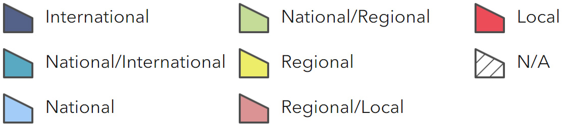
Main Beneficiaries Map
View Main Beneficiaries Map full screen in a new tab View Interactive Map HelpEcosystem service analysis
The following sections show the analysis used to determine key Ecosystem Service opportunities within the area. These opportunities have been combined with the analysis of landscape opportunities to create Statements of Environmental Opportunity. Please note that the following analysis is based upon available data and current understanding of ecosystem services. It does not represent a comprehensive local assessment. Quality and quantity of data for each service is variable locally and many of the services listed are not yet fully researched or understood. Therefore analysis and opportunities may change upon publication of further evidence and better understanding of the inter-relationship between services at a local level.
Note that numbers and figures in the body of the text are based on the 2014 profiles, unless otherwise stated.
Provisioning Services
Food provision
Assets/attributes: main contributors to service –
- Soils
- Semi-natural habitat
State – Only 1.5 per cent of the soils are grade 2, 55 percent of the area is grade 3 and 31 per cent grade 4.
In 2009 the area had:
- 11,131 ha of cereals (15 per cent of NCA)
- 1,580 ha of oilseeds (2 per cent of NCA)
- 1,0 per cent, 7 ha of “other arable crops” (includes field beans, peas, maize, miscanthus and short rotation coppice) (1 per cent of NCA)
- 55,853 ha of “grass and uncropped land” (77 per cent of NCA)
- 80,720 cattle
- 286,016 sheep
- 33,636 pigs
- 21 specialist poultry farms
- 140 dairy farms (down from 234 in 2000).
The area has a good range of outlets which use and sell local produce: from the restaurants and food shops of Richmond, Masham and Harrogate, to a number of well-known dining pubs and the local food centre to fodder, at the Great Yorkshire Showground in Harrogate. A number of livestock and dairy farms sell produce direct to consumers, through farm shops and box schemes.
Unusual specialist food producers include deer and bison farms.
Main beneficiary – Regional
Analysis – Much of the agricultural land in the area is primarily suited to livestock grazing, particularly that on higher ground and with heavy, low grade soils and higher rainfall rates. Much of this land would not be suitable for cultivation to produce other foodstuffs such as cereals, oilseeds or vegetables.
Meat production is very important to the local economy and landscape, helping to maintain the pastoral scenery and giving a reason to retain and repair traditional field boundaries in the form of drystone walls and hedges. Grazing livestock are also crucial for management and retention of many of the area’s priority habitats, particularly acid and neutral grasslands, moorland, hay meadows and some wetlands. Dairy production has been a strong feature of the area, but has declined in recent years, as it has done nationwide.
There is likely to be demand for increased production of food. Where this happens farmers should be encouraged to minimise negative impacts for the local environment and local communities by:
- using best farming practice to protect soil quality, avoid pollution, reduce greenhouse gas emissions, maximise animal welfare;
- retaining landscape features such as hedges, copses, ponds, wetlands etc., particularly where these support food production;
- using modern technology and novel approaches such as precision farming, integrated pest management and minimum tillage cultivation.
Many of these measures will also help to protect or enhance soil quality on agricultural land which can be beneficial for food production, climate regulation, water flow regulation, water quality and biodiversity.
Where farmers are producing food in designated areas (AONB, SSSI, registered Park and Gardens) they should be encouraged to market their produce by linking it to the special environmental qualities of the area.
Opportunities – Encourage farmers to follow best farming practice, to retain natural features and habitats on farms and to use modern technology and techniques to help maximise the value of food production while optimising environmental impact.
Support farmers in using the distinctive characteristics of the area to market their products.
Support continuity of traditional practices such as hay-making where these maintain important landscape features, and use of traditional breeds where these can help maintain wildlife-rich, but agriculturally marginal, habitats.
Principal services offered by opportunities –
- Food provision
- Climate regulation
- Regulating water quality
- Regulating soil quality
- Regulating soil erosion
- Sense of place/inspiration
- Sense of history
- Biodiversity
Timber provision
Assets/attributes: main contributors to service –
- Soils
- Woodland
State – The NCA has nearly 10 per cent woodland cover, including 8,390 ha of woodland (4,550 broadleaved, 2,811 coniferous, large numbers of hedgerow and in-field trees, many veteran in age and one sawmill.
Main beneficiary – Regional
Analysis – Many of the small woodlands on estates are under proactive management for timber production, in addition to management for firewood and shooting.
Forestry activity can present a risk of soil erosion and water pollution, however following best practice guidelines, and using approaches such as continuous vegetation cover management, can avoid these risks.
Forestry Commission research (Woodland for Water, Forestry Commission, 2013) has highlighted several areas within the NCA where new woodland planting could make a particularly valuable contribution to reducing diffuse pollution and flood risk. Woodland planting to address diffuse pollution is highlighted for an area in the far north of the NCA, near the River Tees, and along the River Nidd and Oak Beck. Woodland planting to reduce flood risk is highlighted around the Ure and Swale rivers in particular.
Woodland creation could be accommodated within this area, as there is a local forestry industry to support it and new woodland could contribute to a number of other ecosystem services, such as: creating habitat networks; buffering ancient woodland sites; protecting/enhancing the sense of tranquillity.
Care should also be taken to ensure new woodland planting does not damage existing features and services such as archaeology, existing priority habitats/species, landscape character and amenity value.
Where possible production of hardwood timber from native broadleaved tree species should be encouraged. Where this is not feasible coniferous planting schemes that allow for strips of broadleaves along rides, watercourses and perimeters can help to maximise their environmental, landscape and recreation value.
Opportunities – Target new woodland planting for timber to locations where it can help to reduce flood risk/erosion/pollution, buffer/connect existing woodland, enhance tranquillity and where it will not have a negative impact on archaeology, priority habitats/species or amenity value.
Encourage planting of broadleaved woodland, using native broadleaves where possible, to increase supply of hardwood and for the benefit of wildlife, sense of place and recreation.
Encourage use of best practice forestry techniques, and practices such as continuous cover on sites at particularly high risk of soil erosion or causing pollution of watercourses.
Production of softwood timber could be temporarily increased through restoration of plantations on ancient woodland sites to native broadleaved woodland.
Principal services offered by opportunities –
- Timber provision
- Climate regulation
- Regulating water flow
- Regulating water quality
- Biodiversity
Water availability
Assets/attributes: main contributors to service –
- Topography
- Semi-natural habitats
- Watercourses
- Minor aquifers
- Reservoirs
State – The rocks underlying the area have low porosities; storage and flow is within and through fractures and discontinuities such as joints and faults. The NCA does not overlay a major aquifer, however, the majority of the NCA is underlain by the minor Millstone Grit aquifer, which has good hydrological connectivity with surface water and its resource availability is assessed with surface water resources. North of Richmond, the NCA overlays the minor Carboniferous Limestone aquifer (Swale, Ure, Nidd and Upper Ouse Catchment Abstraction Management Strategy, Environment Agency 2004).
The River Tees and one of its major tributaries, the River Greta, run across the north of the NCA. The availability of water from the River Tees and its tributaries is not assessed because the flow is regulated by the Cow Green Reservoir and Kielder Water (Tees Catchment Abstraction Management Strategy, Environment Agency, 2008).
There is no water available from groundwater or surface water resources in the catchments of the rivers Swale, Ure, and Nidd, in order to maintain flow downstream of the NCA (Swale, Ure, Nidd and Upper Ouse Catchment Abstraction Management Strategy, Environment Agency, 2004).
The River Washburn is assessed as having ‘water available’ at low flows. However, this resource availability status is overridden to ‘no water available’ to ensure adequate flows further downstream, specifically at the ‘critical assessment point’ at Tadcaster (south-east of the NCA). The River Washburn has been dammed at several points in the NCA to create reservoirs providing potable water for Harrogate, Leeds and Bradford.
The River Wharfe has ‘no water available’ along this stretch within the NCA (Wharfe and Lower Ouse Catchment Abstraction Management Strategy, Environment Agency, 2005).
The main water abstractions from the Swale, Ure and Nidd are for public water supply and cross-catchment transfers. In the Tees catchment, abstraction mainly takes place downstream of the NCA and is primarily for industry at Teeside. In the River Wharfe and Upper Ouse catchment the majority of abstractions are for public water supply and for fish farms, such as the trout hatchery at Lindley.
Main beneficiary – Regional
Analysis – The high coverage of grassland, combined with the area’s semi-natural habitat will help to encourage infiltration of rainwater and slow runoff, thereby ensuring minor aquifers an increased period in which to recharge and that water is retained in the NCA for longer before flowing into downstream NCAs.
Where there is new residential, tourism or industrial development, the additional water demand created by these could be moderated by the inclusion of rainwater harvesting systems and features to minimise water use.
Opportunities – Maintain and improve infiltration of rainfall by ensuring that semi-natural habitats are well vegetated, agricultural soils are in good condition, and seek to expand the areas of heathland, woodland and permanent grassland where possible.
Plan for new development to include rainwater harvesting systems and features to minimise water use.
Encourage retro-fitting of features to existing development to maximise efficiency of water use.
Principal services offered by opportunities –
- Water availability
- Regulating water quality
- Regulating water flow
Genetic diversity
Assets/attributes: main contributors to service –
- Traditional breeds
- Semi-natural habitats
State – 5 Environmental Stewardship agreements include the supplement for using native breeds at risk to graze land (142 ha).
The Masham breed of sheep originated in the area. There are some producers of meat, dairy and wool from rare-breed livestock, such as Island Heritage woollen clothing and Brymoor Guernsey ice cream, both at Masham.
Main beneficiary – Local
Analysis – Native breeds could play a useful role in the area for management of marginal sites, particularly wetland and rough grassland, where small size, hardiness and ability to thrive on poor grazing make certain native breeds particularly suitable.
Opportunities – Encourage use of native breeds for grazing on semi-natural habitats of marginal agricultural productivity where this will enhance their biodiversity value.
Encourage and facilitate marketing of products from conservation grazing with traditional breeds.
Principal services offered by opportunities –
- Genetic diversity
- Biodiversity
- Food production
- Sense of place/inspiration
Biomass energy
Assets/attributes: main contributors to service –
- Soils
- Biomass crops
- Woodland
State – The NCA has a medium to high potential yield for short rotation coppice (SRC) throughout the NCA, with higher potential yield around Richmond in the north, and a medium potential yield for miscanthus (Opportunities and optimum sitings for energy crops, Natural England, 2010).
As the area is comparatively well-wooded (9.6 per cent of NCA), there is good potential for woody biomass production. In 2012 there were 4 woodfuel suppliers, and 12 biomass boilers (with a capacity of 5,207 kWh).
Main beneficiary – Local
Analysis – Woodfuel could be generated through clearance/thinning/restocking of conifer plantations, management of plantations specifically for fuel.
There could also be more proactive management of existing woodland, where this would not undermine its wildlife value, particularly on ancient sites.
Opportunities – Encourage positive management of existing woodland to provide woody biomass, where this is consistent with nature conservation objectives and will not be detrimental to public access/recreation.
Encourage use of by-products from timber processing for energy generation, where appropriate.
Principal services offered by opportunities –
- Biomass energy
- Biodiversity
Regulating Services
Climate regulation
Assets/attributes: main contributors to service –
- Soils
- Semi-natural habitats
- Farmland
State – There is generally a low soil carbon content of 0 to 5 per cent throughout the NCA, although there are areas with a very high carbon content of 20 to 50 percent underlying the moorland west of Harrogate and west of Catterick Garrison.
There is higher carbon storage potential associated with 8,390 ha of woodland in the NCA (9.6 per cent of the NCA area), and the more than 1,000 ha of heathland, marsh, grassland, and wetland habitats.
Main beneficiary – Regional
Analysis – Carbon stores in the area are likely to be in peaty soils associated with moorland and wetlands, woodland and its soils, and soils associated with permanent grassland. Existing woodland cover and agricultural land (grassland and arable) could also be managed to further enable carbon sequestration and storage.
As a transitional landscape between lowland and upland areas, with good potential to develop a strong habitat network, the area has a particularly important role to play in helping wild species adapt to climatic change, particularly where conditions necessitate migration to higher land. River valleys could play a critical role as they already provide movement corridors between upland and lowland and they could be strengthened by increasing the width of riparian habitats and filling in gaps between existing semi-natural habitats.
Opportunities – Explore opportunities for tree planting to increase carbon sequestration/storage, where in keeping with landscape character and not detrimental to nature conservation, food production or archaeology.
Create networks of semi-natural habitats and improve existing wildlife corridors (especially along rivers) to facilitate movement of species as the climate changes, particularly by creating good movement corridors between upland and lowland areas.
Encourage farming practices which maximise carbon content of agricultural soils, and minimise greenhouse gas emissions associated with farming activity (such as minimum tillage, incorporation of organic matter, combination machinery, precision targeting of fertiliser).
Protect existing semi-natural habitats such as permanent pasture, heath/moorland and fens, particularly where on peat soils, for their carbon stores and for the contribution to ecological resilience.
Encourage incorporation of features into new development which will minimise resource use, and therefore greenhouse gas production, and help with adaptation to climate change.
Principal services offered by opportunities –
- Climate regulation
- Biodiversity
- Regulating water flow
- Regulating water quality
- Regulating soil quality
- Regulating soil erosion
- Sense of place/inspiration
- Biodiversity
Regulating coastal erosion and flooding
No information available.
Regulating water quality
Assets/attributes: main contributors to service –
- Geology
- Soils
- Semi-natural vegetation
- Watercourses
- Farmland
State – For information regarding the current state of water quality within this NCA, refer to the Environment Agency (Draft river basin management plan maps).
Main beneficiary – Regional
Analysis – Issues affecting water quality include point source discharges from sewage works, water industry storm discharges and diffuse pollution from agriculture.
Run-off of nutrients, sediment and herbicides from farmland are key issues. Watercourses adjacent to livestock farms may be at particular risk where stock have access to watercourses and where farms have insufficient slurry storage and/or poor farm infrastructure. Good farming practice to help reduce the risks of pollution in the NCA could include maintaining good soil structure, appropriate timing and application of slurry/ manure/ fertiliser (not on saturated or frozen ground) and fencing to exclude livestock from watercourses.
In areas with a concentration of dairy farming, maize is a common fodder cop. Maize fields can be at high risk of soil erosion, particularly on sloping land. The risks can be mitigated by planting the crop across slopes, using grass buffer strips to slow and trap run off and by using a cover crop or rough surface cultivation after harvesting to prevent sediment being washed into water courses during winter.
Creation of buffer strips along watercourses and slopes at high risk of surface run-off could help to protect water quality from sediment, nutrient and chemical run off. Buffer strips can either be of grassland or woodland, depending on which is more appropriate in relation to landscape character and riparian/aquatic species.
Forestry Commission research suggests that woodland planting could play a particularly important role in reducing diffuse pollution of watercourses in areas around the Tees and Nidd and Oak Beck.
Creation of sediment traps/ponds and creation of wetlands or reedbeds can also play an important role in intercepting pollutants from agricultural land.
Advice and grants from the Catchment Sensitive Farming programme in the north of the NCA have sought to reduce sedimentation, nutrient and herbicide run-off by encouraging such good farming practice and funding improvements to farmyard infrastructure, cattle drinking/feeding points, and fencing of watercourses.
Opportunities – Encourage adoption of good soil management and good farming practice that reduces sedimentation and run off from arable, mixed and livestock farms, such as incorporation of organic matter, avoiding heavy stocking and machinery use during very wet conditions, creation of buffer strips and keeping livestock away from watercourses.
Encourage farmers and industry to update and improve infrastructure to minimise pollutant load to watercourses and risks of pollution incidents.
Support and encourage the creation of grassland and woodland buffer strips alongside watercourses, especially where adjacent land is improved grassland or arable.
Create sediment traps, ponds and wetland habitats to intercept pollutants from farmland, especially on cultivated land and improved grassland.
Exclude stock from watercourses to avoid bank side erosion and sedimentation.
Encourage inclusion of sustainable drainage systems in new development, and retro-fitting of features to existing development where possible.
Principal services offered by opportunities –
- Regulating water quality
- Biodiversity
- Food production
- Regulating soil quality
- Regulating soil erosion
- Regulating water flow
- Recreation
Regulating water flow
Assets/attributes: main contributors to service –
- Geology
- Soil
- Semi-natural habitat (particularly riparian woodland, permanent grassland and wetlands)
State – Fluvial flooding in this NCA is generated from heavy rainfall in the Pennines where many of its rivers rise. Towns and villages in the NCA with more than 100 properties at risk of river flooding include Masham within the NCA, Ripon, Knaresborough, Catterick, Boroughbridge and York downstream of the NCA.
There are significant storage reservoirs in the NCA and upstream, along the Ure, Nidd, and Washburn. In particular Fewston, Swinsty and Lindley Wood reservoirs, situated upstream of the Washburn’s confluence with the River Wharfe, attenuate flood waters from the Washburn, and reduce flood risk downstream.
Controlled washlands also contribute to flood management: washland along the River Wharfe at Harewood (in the southeast of the NCA) protects arable land in lesser floods, and contributes to flood protection downstream (Ouse Catchment Flood Management Plan, Environment Agency, 2010).
In the north of the NCA, the River Tees runs through a largely rural area and poses a ‘low to moderate’ risk of flooding; however, Barnard Castle and Staindrop are at risk of flooding from the Tees and its tributaries (Tees Catchment Flood Management Plan, Summary Report, Environment Agency, 2009).
Richmond and Catterick Garrisons are at risk of flooding from the River Swale, as levels rise quickly after high rainfall events on the Pennines.
The River Ure also has large flows as a result of heavy rainfall in the Pennines. There are notable areas of agricultural land at risk of flooding, and the village of Masham (containing almost 400 properties) is at risk of flooding from the Ure and its tributary Swinney Beck.
There is a risk of flooding from the Nidd in the area from Clint downstream to Ripley, north-west of Harrogate.
In the south of the NCA, the River Wharfe responds rapidly to rainfall events. Flood peaks are generated by heavy rainfall in the upper catchment, and flood risk can become severe, having particular affect on communities downstream of this NCA.
Major transport links at risk from flooding within the NCA include the A59 to Harrogate from the rivers Washburn and the Nidd, and the A6108 at Richmond and railway south of Catterick from the River Swale.
Main beneficiary – Regional
Analysis – Flooding of residential areas, farmland and roads is a major issue in this NCA, as it has a large number of major rivers draining extensive upland catchments. A number of catchment-based initiatives to address flood risk have been set up in the area in recent years, but the biggest opportunities to resolve flooding within the area lie upstream in the Pennines, particularly in terms of measures to slow run-off, reduce synchronicity of peak flows and increase the water holding capacity of habitats and storage areas.
The Ripon Multi-Objective Project was set up as a pilot, funded by Defra, to look at land use and land management within the catchments of the River Skell, River Laver and Kex Beck that could reduce the risk of flooding in Ripon, while also minimising soil erosion and sedimentation of watercourses. Action encouraged and funded under the scheme included: tree and hedge planting, fencing off woodland and watercourses, grip-blocking and ditch management (Nidderdale AONB, Accessed July 2013).
The Environment Agency aims to promote agricultural land management changes to reduce run-off in the River Tees catchment, such as pond creation, buffer strips, and more sustainable drainage.
In order to address flood risk, the Environment Agency aims to work with local authorities to identify and protect functional flood plains and reconnect flood plains to their rivers so as to reduce the risk of flooding to people and property. They also encourage the re-use of former mineral workings to deliver multi-purpose washlands for wildlife, flood management and local communities; and the creation of winter storage reservoirs by the agricultural sector. They also support moorland grip blocking and gill planting outside the NCA, to reduce the risk of flood generation upstream (Ouse Catchment Flood Management Plan, Environment Agency, 2010).
Forestry Commission research suggests that new woodland planting could be particularly helpful in reducing flood risk if focused around the Ure and Swale rivers. This is likely to be most effective along tributaries to the main rivers, rather than along the main rivers themselves.
A modelling study predicted that planting flood plain woodland at four sites in the River Laver catchment totalling 40 ha in area (<1 per cent of catchment) could delay the progression of a 1 in 100 year flood by around one hour. This had the potential to reduce the flood peak at Ripon by 1 to 2 percent by desynchronising the flood contribution from the adjacent tributary, the River Skell. A much greater reduction was expected with a larger planting area (Woodland for Water: Woodland Measures for meeting Water Framework Directive Objectives, Forest Research, 2011).
Opportunities – Encourage and facilitate work on farms to slow run-off (such as tree planting, grass buffer strips, restoration of hedges, grip-blocking and the creation of water storage reservoirs).
Secure good farming practice to slow run-off by enhancing soil structure, reducing soil erosion and increasing land surface roughness through either land cover or rough cultivation over winter.
Encourage and facilitate creation of flood storage along river corridors, and establish water-holding habitats such as wet woodland, ponds and other wetlands, and manage them so that they provide benefits for biodiversity and enhance local landscape character.
Protect existing flood plains, and where feasible, seek to reconnect them to their rivers, especially where heavily modified, for example along the Tees and Greta.
Principal services offered by opportunities –
- Regulating water flow
- Regulating soil erosion
- Recreation
- Biodiversity
Regulating soil quality
Assets/attributes: main contributors to service –
- Soils
- Soil flora and fauna
- Semi-natural habitat
- Farmland
State – Soil types range from peaty soils on the western upland fringe, heavy to more fertile loamy soils to the east. Glacial till covers much of the area, making the land slow-draining and prone to waterlogging.
55 per cent of the area is Grade 3 agricultural land, and 31 per cent is Grade 4.
Main beneficiary – Local
Analysis – Much of the NCA is covered by soils that are prone to waterlogging, and so are particularly vulnerable to compaction, capping and poaching, all of which in turn can exacerbate run-off and lead to increased soil erosion.
Soils on land used for arable production are at risk of: compaction, capping, reduction in organic matter and decline in soil flora and fauna. However much of this risk can be minimised through good farming practice and adoption of agri-environment options which help to maintain soil structure, organic matter and soil flora and fauna.
Soil organic matter can be improved through measures such as incorporating compost/manure/straw and use of green manures or winter cover crops. Soil structure also benefits from increased organic matter and can be further protected and improved through measures such as minimum tillage techniques, aeration and avoiding heavy stocking and use of machinery on fields during very wet conditions.
Opportunities – Encourage farming practices which protect and enhance soil structure and biodiversity in arable soils, such as minimum tillage techniques, incorporation of organic matter and aeration, and avoiding farm machinery use or heavy grazing levels during very wet conditions.
Principal services offered by opportunities –
- Regulating soil quality
- Regulating soil erosion
- Regulating water quality
- Regulating water flow
- Recreation
- Biodiversity
Regulating soil erosion
Assets/attributes: main contributors to service –
- Soil
- Soil flora and fauna
- Semi-natural habitat
- Farmland
State – Over half of the soils covering this NCA (58 percent) have a low risk of soil erosion, namely the slowly permeable seasonally wet slightly acid but base-rich loamy and clayey soils (41 per cent), the slowly permeable seasonally wet acid loamy and clayey soils (14 per cent) and the freely draining flood plain soils (3 per cent).
The freely draining slightly acid loamy soils (30 per cent) have enhanced risk of soil erosion on moderately or steeply sloping land where cultivated or bare soil is exposed. There is also potential for wind erosion on coarse textured variants.
The slowly permeable wet very acid upland soils with a peaty surface (6 per cent) are at risk of gullying/ hagging (and loss of particulate organic matter) where surface vegetation is damaged or lost.
The very acid loamy upland soils with a wet peaty surface (1 per cent) suffer from a combination of rapid runoff, easily damaged peat layers and steep slopes.
Many of the slightly acid loamy and clayey soils with impeded drainage (3 per cent) are prone to capping/slaking, leading to increased risk of erosion.
The Catchment Sensitive Farming target area that covers the northern section of the NCA has a specific priority to reduce loss of sediment from local farms.
Main beneficiary – Local
Analysis – Lighter soils on more sloping ground, particularly where cultivated, are at most risk of soil erosion. Soils which have low levels of organic matter, or which have been damaged through compaction, capping or poaching, or where they are alongside spatey major rivers are also particularly prone to erosion.
The large number of major rivers running through the NCA means that there are long sections of river banks which are at risk of erosion, particularly where livestock have access. Fencing livestock away from rivers would help to reduce soil erosion risk, although fencing should be focused so as to avoid accelerating the spread of invasive species (such as Himalayan balsam) and reducing the condition of habitats for priority species (such as water vole) by removing grazing. Upstream measures to reduce the velocity of the major rivers would also help and could take the form of tree-planting, habitat restoration to reduce the speed of run-off and increase infiltration, grip blocking and increasing storage capacity in both habitats and reservoirs.
Drainage of upland peaty soils may also result in increased oxidation of the peat and thus loss of carbon and soil wastage. Measures will be beneficial that retain water in situ, ensure good vegetative cover, and avoid over grazing/trampling or damage by mechanised activities.
Soil erosion may be exacerbated by climate change in some areas, particularly where soils are vulnerable to erosion by water during periods of high rainfall. Increased frequency and severity of peak flow events could also accelerate bankside erosion of major rivers, with possible implications for river morphology, sedimentation and loss of riparian habitats and farmland.
Catchment Sensitive Farming priority capital items for 2013/14 grants include watercourse fencing, hard bases for livestock drinkers or feeders and sediment ponds and traps.
Opportunities – Encourage adoption of farm management practices, and agri-environment options, that minimise erosion risk, such as good soil management and incorporation of organic matter.
On arable land encourage creation buffer strips of permanent grassland or scrub and woodland alongside watercourses and in-field grass strips, to slow run-off.
In cases of severe erosion encourage conversion to practices such as spring (rather than winter) cropping, minimum tillage techniques and reversion of arable land to grassland.
Fence livestock away from river banks to reduce erosion, where this will not encourage the spread of invasive species or displace priority native species, or encourage reduced levels of grazing adjacent to watercourses.
Principal services offered by opportunities –
- Regulating soil erosion
- Regulating water quality
- Regulating water flow
- Food production
Pollination
Assets/attributes: main contributors to service –
- Semi-natural habitats (heathland and moorland)
- Pollinator species
State – There is a lack of direct evidence about this service in the NCA. However, the lowland heath, upland moorland, hay meadows, hedgerows and flower-rich road verges will all act as valuable nectar sources for pollinating insects in the NCA. The proximity of these habitats to arable land means that there is good potential for this service to be provided within the NCA.
Between 2005 and 2013 there were 9 Environmental Stewardship agreements in the NCA that included options for creation of nectar-rich and floristically enhanced field margins, covering 16.04 ha (Genesis Schemes Reporting System (GENREP), Natural England, 2013).
Main beneficiary – Local
Analysis – The most significant need for pollination of agricultural crops in this NCA is for the 1,685 ha of oilseeds. The remainder of the arable crops in the area are largely wind or self-pollinated, with the exception of some of the crops grouped into the “other arable crops” category of the June Census, which accounted for 169 ha in 2009 and includes insect-pollinated crops such as beans.
The mixed nature of farmland, interspersed with hedges, in the east of the NCA will have good potential for pollination services.
Hedgerows will be a particularly valuable food source and habitat for pollinating insects if they are left more than 1 year between cutting, and if they have flower rich margins alongside them (Ecosystem Services from Environmental Stewardship that benefit agricultural production, Natural England, 2012). Less frequent cutting of hedges will also allow shrub species to produce more fruit, thereby benefitting a range of insects, mammals and birds.
Creating nectar-rich habitats to support pollinating insects benefits a range of other wildlife, particularly insectivorous small mammals and birds as well as bats.
Opportunities – Protect and restore existing flower-rich habitats, particularly unimproved grassland, meadows and heathland, and create new areas where possible, to provide additional nectar sources and habitat.
Encourage use of integrated crop management techniques, particularly use of biological rather than chemical pest control, to avoid harm to nontarget pollinating insects.
Encourage less frequent cutting of hedges and manage the timing of cuts to road verges to allow more profuse flowering, thereby supporting more nectar feeding insects, and providing fruit for insects, birds and mammals over winter.
Create strips and small areas of nectar-rich habitat on and next to arable land, in the form of nectar flower strips, flower-rich grass buffer strips, beetle banks, arable flora-rich headlands, particularly where these can provide links between isolated flower-rich grasslands and heathlands.
Support research into the extent and value of natural pollination services, and communicate results to farmers.
Principal services offered by opportunities –
- Pollination
- Food production
- Biodiversity
- Regulating water quality
Pest regulation
Assets/attributes: main contributors to service –
- Beneficial predator species
- Semi-natural habitats
State – There is a lack of direct evidence about this service in the NCA. However, good habitat likely to support beneficial predators next to arable crops, such as hedgerows/buffer strips/flower-rich road verges/beetle banks, act as valuable sources for pest regulating species in the NCA. The network of these habitats next to arable land, particularly in the more mixed farming landscape to the east, means that there is good potential for this service to be provided within the NCA.
Main beneficiary – Local
Analysis – There is evidence to suggest that certain habitats (for example hedges, flower-rich buffer strips, unimproved grassland) can support populations of beneficial predator species which can help control common agricultural pests (for example, ladybirds regulating populations of aphids) (Ecosystem Services from Environmental Stewardship that benefit agricultural production, Natural England, 2012).
Habitats which provide a nectar source, shelter and additional prey species, such as the NCA’s hedgerows, grasslands, woodlands and heathlands all have the potential to increase beneficial predator numbers.
Where these, or temporary flower-rich habitats such as buffer strips or beetle banks, occur alongside arable crops, as they do in the east of the NCA, it is likely that they afford some pest control.
If the approach could be built upon in this area, to maximise the agronomic benefits, it could play a valuable role in terms of increasing production of arable crops while reducing the use of pesticides and associated risk to water quality, human health and non-target species.
Opportunities – Encourage less frequent cutting of hedges and manage the timing of cuts to road verges to allow better habitat to develop for species of invertebrate and birds which can control crop pests.
Encourage creation of buffer strips and beetle banks in arable fields, particularly through agri-environment schemes.
Encourage use of integrated crop management techniques, particularly the use of biological rather than chemical control, to avoid harm to non-target beneficial predator species.
Support research into the extent and value of natural pest control services, and communicate results to farmers.
Principal services offered by opportunities –
- Pest regulation
- Food production
- Biodiversity
- Regulating water quality
Cultural Services
Sense of place/inspiration
Assets/attributes: main contributors to service –
- Semi-natural habitat (particularly native woodland and historic parkland)
- Geology
- Rivers
- Topography
State – The area’s sense of place is derived from its position between upland and lowland, its ridges and hills, mixed farming and a well-wooded, traditional rural feel. The noticeable unity of the built environment, predominantly Millstone Grit and limestone, also contribute to this service.
The area provides inspiration to many and its beauty recognised with the inclusion of 20,550 ha (24 per cent) within the Nidderdale and the North Pennines AONB. Senses of inspiration and escapism are provided by the open and expansive moorland tops along the western edge that contrast with the more small-scale, wooded landscapes in the valley bottoms, along with their historic settlements and rivers.
Main beneficiary – Regional
Analysis – The sense of place varies somewhat throughout the character area: more upland, pastoral and treeless on the hill tops in the west, more mixed/arable and well-wooded on the side slopes, with lowland farmland with hedges in the east. The whole area is united by its location on the eastern flanks of the Pennine uplands and its tranquil, rural character, which sets it apart from its more industrial neighbours to the north and south.
Many of the vistas within the NCA are very picturesque – in the common sense of the word, but also in an academic sense in relation to “The Picturesque” art movement of the 18th century. William Gilpin, an 18thcentury scholar who wrote widely about “The Picturesque”, referred to the view from Mowbray Point at Hackfall Woods as “one of the grandest and most beautiful bursts of country that the imagination can form.”
One of the best known visitors to take inspiration from the area was the artist J M Turner who often stayed at Farnley Hall in Wharfedale; the River Greta was a favourite location for him to sketch.
Opportunities – Protect the area’s well-wooded, pastoral and mixed farming character by:
- Ensuring retention and sympathetic management/renewal of hedgerows, hedgerow trees and woodland.
- Communicate the importance of sympathetic management of veteran trees on both arable and pastoral land, and encourage planting of replacement trees.
- Restore and manage historic estates and parkland, including restoring features like vistas and parkland trees.
- Encourage retention of permanent pasture.
- Encourage re-stocking of conifer woodland with broadleaved species.
- Encourage new woodland planting where it is in keeping with landscape character and does not undermine nature conservation, food production or archaeology.
Protect the unity of the built environment, particularly in conservation areas and the AONB, by encouraging use of traditional materials and techniques, while allowing for innovative and sustainable design.
Protect the rural, tranquil and ancient character of some parts of the NCA by managing development pressure and increasing levels of traffic to minimise their impact.
Principal services offered by opportunities –
- Sense of place/inspiration
- Tranquillity
- Sense of history
- Biodiversity
- Recreation
Sense of history
Assets/attributes: main contributors to service –
- Buildings
- Earthworks
- Field boundaries
- Veteran trees, ancient woodland and parkland
- Geology
State – The NCA has:
- 15 Registered Parks and Gardens, covering 1,770 ha;
- 151 Scheduled Monuments;
- 2,622 Listed Buildings;
- 1 World Heritage Site.
There are currently 92 designated monuments at risk in the Pennine Dales Fringe.
Important concentrations of pre-historic carved rocks can be found in the upland areas in the south-east of the NCA.
Main beneficiary – International
Analysis – This area is rich in historic remains from many different periods of history. From its valuable collection of pre-historic carved rocks, through Roman roads (Dere St) and settlements to designed landscapes and grand country houses.
There are several monastic estates and designed landscapes often located at valley openings, including Harewood, Aske, Ripley, Hawnby, Fountains Abbey, Middleham, Norton Conyers and Temple Grounds Richmond, with several originating from medieval hunting grounds or castles.
The sense of history in the area is embodied not just in archaeological sites, listed buildings and historic parkland, but also in the well-preserved stone-built villages and market towns and the traditional hedgerow and stone wall networks that survive relatively intact in some areas.
Opportunities – Protect the unity of the built environment, particularly in conservation areas and the AONB, by encouraging use of traditional materials and techniques, while allowing for innovative and sustainable design.
Ensure protection and sympathetic management of historic parkland, restoring key features, including veteran trees, whilst making them relevant to the needs of 21st century, providing access where possible.
Ensure sympathetic management and high-quality interpretation of historic sites and archaeology, particularly where this protects and explains the wider context of historic landscapes.
Principal services offered by opportunities –
- Sense of history
- Sense of place/inspiration
- Biodiversity
- Recreation
- Tranquility
Tranquility
Assets/attributes: main contributors to service –
- Topography
- Semi-natural habitat (particularly moorland and native woodland)
- Watercourses
State – 65 per cent of the NCA is classified as ‘undisturbed’, a decline from 85 per cent in the 1960s.
Scores for tranquillity in the area range from 50 to -66, with an average of 5.
Main beneficiary – Local
Analysis – Tranquillity is most significantly affected in the south by Harrogate and the roads connecting it and rural commuter settlements to Leeds. In the north of the NCA Richmond, Gatterick Garrison, Barnard Castle and surrounding A-roads and the main A1 trunk road impact on tranquillity.
Traffic pressure on main commuter routes around Leeds and Harrogate is increasing with negative implications for tranquillity, as well as safety of recreational users. Changing working patterns may help to alleviate some of this pressure, particularly if communication links, such as high speed broadband to rural areas can be improved to encourage more people to work from home.
A sense of tranquillity is thus most likely to be found away from these areas, particularly within the wooded river valleys and where pastoral landscapes are reinforced by thick hedgerows and traditional features.
Opportunities – Protect the most tranquil areas from intrusion and inappropriate development.
Manage increasing traffic levels to minimise intrusion through noise pollution and risk to other road users.
Support improvement of communication links, particularly broadband, to maximise possibilities for people to work from home rather than commuting by car.
Principal services offered by opportunities –
- Tranquillity
- Sense of place/inspiration
- Sense of history
Recreation
Assets/attributes: main contributors to service –
- Rights of way
- Watercourses
- Reservoirs
- Semi-natural habitat (particularly woodland and parkland)
State – Recreation and access are supported by 1,425 km of rights of way (equivalent to 1.63 km per km2), including the Coast to Coast path, Ebor Way, Nidderdale Way, Way of the Roses, Walney to Wear or Whitby and Teesdale Way long-distance paths. Overall there are 2,456 ha of accessible land.
Opportunities for angling are provided by the string of reservoirs along the Washburn valley in the south of the NCA, and some stretches of the major rivers.
The NCA’s numerous major rivers also provide additional high-quality opportunities for canoeing, kayaking and swimming and wildlife watching
Main beneficiary – Regional
Analysis – The area provides a pleasant setting for various forms of recreation. The verdant, well-wooded landscape is an attraction in its own right; the area also has many valuable assets for recreation in the form of historic parklands and country houses and major rivers and reservoirs. The Nidderdale AONB covers 24 per cent of the NCA and attracts many visitors and provides information about the area’s special qualities.
Cycling is a very popular sport in the area, with the national Cyclists Touring Club originally forming in Harrogate. The area is particularly well-suited to road biking because of its network of quiet lanes and many moderate to challenging hills.
The River Washburn Valley, encompassing the reservoirs of Thruscross, Swinsty, Fewston and Lindley Wood is particularly important for water-based recreation. The reservoirs are open to the public with a variety of footpaths and picnic facilities for visitors. Bird watching is popular, with the reservoirs and the mixed plantations in the lower part of the valley supporting a variety of woodland birds and wintering wildfowl including mallard, teal and pochard. Thruscross Reservoir provides sailing facilities and an outdoor centre. Below the dam wall in the Washburn Valley, canoeists have an agreement with Yorkshire Water Services Limited whereby controlled releases allow canoe and kayak events to be held on a river course modified for the purpose.
Opportunities – Manage increasing traffic levels, particularly around towns/cities and on main commuter routes, to minimise risk to recreational road users (walkers, cyclists and horseriders).
Enhance provision of new linear and circular off-road routes suitable for cyclists, horseriders and walkers, and increase promotion of existing off-road routes, to further promote outdoor recreation in the area.
Improve access by ensuring that paths are well maintained and signposted and that some surfaced paths are provided to ensure easy access walks.
Seek to further improve and protect water quality, particularly in the main rivers, to enhance the enjoyment and safety of recreational river users.
Principal services offered by opportunities –
- Recreation
- Biodiversity
- Tranquillity
- Regulating water quality
Biodiversity
Assets/attributes: main contributors to service –
- Geology
- Soils
- Watercourses
- Semi-natural habitats (esp. native woodland and species-rich grassland)
State – There are two internationally designated sites within the NCA: a relatively small portion (less than 1 per cent) of the North Pennine Moors SPA/SAC, which holds much of the upland heathland and the major extent of blanket bog in England and is of International importance for several upland breeding bird species; and the North Pennine Dales Meadows SAC around Richmond, designated for its hay meadows.
There are also 19 SSSI in the NCA, the largest of which is the West Nidderdale, Barden & Blubberhouses Moors SSSI in the north of the NCA, designated for its nationally important assemblage of moorland breeding birds including merlin, golden plover, snipe, curlew, redshank, teal and short-eared owl (SSSI Citation, Natural England Website, 2010). The majority of the other SSSI in the NCA are designated for their woodland, neutral grassland and fen.
There is over 3,000 ha of BAP priority habitat within the NCA (3 per cent of the NCA), 40 per cent of which is comprised of lowland mixed deciduous woodland. Other BAP habitats include upland heathland, upland hay meadows and wet woodland.
The NCA also has 177 Local Wildlife Sites, covering 2,496 ha (3 per cent of the NCA).
The major rivers, along with associated river valleys, wetlands and reservoirs, are major wildlife assets. The rivers support populations of otter, water vole, trout, lamprey, white-clawed crayfish and freshwater mussel. The wooded river corridors are also important for bat species. The wet grassland alongside rivers in some of the more open valleys, particularly the Wharfe Valley, are important winter feeding grounds for wading birds, which nest in the Yorkshire Dales and Pennines to the west of the NCA.
The Harewood Estate has been the location for a very successful red kite reintroduction project.
Higher ground in the north and west parts of the NCA is home to black grouse. The NCA is ranked by Natural England specialists as in the top 5 in the country for hen harrier and top 10 for lapwing.
Main beneficiary – National
Analysis – The quality of rivers and riparian habitats are of critical importance to the biodiversity of the area. These areas are also particularly vulnerable to the spread of non-native invasive species, for example Himalayan balsam along the River Ure.
River corridors also host a number of valuable habitats. The ancient woodland sheltered by the river valleys is a priority habitat in its own right, with some stretches designated as SSSI (including Lower Swaledale Woods and Grasslands, Hackfall Woods and Brignall Banks) as well as providing corridors for wildlife to move through. The wet grasslands, fen and meadows alongside some of the rivers are also some of the most valuable wildlife sites in the NCA, both for plants and birds.
Woodlands are a very valuable wildlife resource in the area and could be enhanced through: appropriate management of existing woodland; restocking of conifer plantations with broadleaves (especially on PAWS sites); creation of buffers around ancient woodland sites; tree-planting to connect isolated fragments of woodland and extend existing sites.
Veteran trees are a notable component of the area’s biodiversity, providing nesting/roosting sites and food for a large number of species including barn owls, tawny owls and species of, bat and rare deadwood eating insects. Livestock and arable farming can have detrimental effects on veteran trees that can shorten their life expectancy.
Soil compaction, nutrient/herbicide application, cultivation and grazing and rubbing by livestock can all be very damaging. Arable farmers should be strongly encouraged to leave a large uncultivated buffer around trees (at least the extent of the canopy) where nutrients and agricultural chemicals are not applied. Livestock farmers should be encouraged not to apply nutrients or herbicides around the base of trees, and to avoid compaction by fencing off particularly sensitive trees where possible. On some estates young trees are being planted near veteran trees to replace them when they die.
Hedgerows provide vital cover, nesting sites and food for wildlife in the NCA, particularly in arable and intensive dairy farming areas. Some hedgerows in the area are cut very short each year. The wildlife value of such hedgerows could be greatly increased by the addition of hedgerow trees and by being cut every third year, as flowers and fruit only occur on second year growth and less regular cutting would allow them to become taller and thicker and therefore more valuable as wildlife movement corridors.
Hay meadows and unimproved grasslands are an important resource in the area, both for maintaining populations of rare plant species, but also supporting nectar-feeding insects as well as populations of ground nesting birds. Rough grazing land on the edge of Pennine moorlands is particularly important as breeding and feeding grounds for wading birds.
Opportunities – Create new broadleaved woodland where it will buffer, connect and extend existing sites (particularly ancient woodland) and where it can deliver benefits for water quality, flood risk reduction and recreation, without undermining archaeology, species of open ground or landscape character.
Improve management of existing woodland for the benefit of wildlife and restock conifer plantations (particularly plantations on ancient woodland sites) with broadleaves.
Incorporate broadleaved species into key areas within existing and new coniferous plantations to maximise their wildlife, landscape and recreation value.
Create new wetland areas where they will connect, buffer or extend existing sites, and where they can help to reduce flood risk and pollution of watercourses.
Create new grassland where they will connect, buffer or extend existing sites and where they will contribute to water quality, flood alleviation and landscape character.
Ensure positive management of existing grassland to maintain diversity of flora and fauna species.
Create key linkages in semi-natural habitats where they will help wildlife move and adapt to a changing climate.
Encourage less frequent cutting of hedges, preferably every third year, to increase flowering and berry production to provide food for insects, birds and small mammals, and to increase their size.
Support restoration of hedgerows along old hedge lines, particularly where these connect up isolated patches of woodland, and gapping up of existing hedges.
Control non-native invasive species to reduce the threat to priority habitats and species, particularly Himalayan balsam along major rivers.
Encourage creation of flood storage areas in river valleys, and establish wet grassland and other wetland habitats with appropriate management to create favourable condition for priority species such as a wading birds and rare flowering plants, and to strengthen local landscape character.
Allow rivers to follow more natural courses, to improve in-stream ecological diversity and create a range of fresh water habitats such as oxbow lakes and wetlands.
Encourage best farming practice to protect/enhance soil quality, minimise soil erosion and minimise water pollution.
Create buffer strips of grassland, scrub and woodland alongside watercourses to provide wildlife movement corridors and to protect watercourses from diffuse pollution from agriculture.
Remove artificial barriers to fish migration and install fish passes where removal of barriers is not possible.
Principal services offered by opportunities –
- Biodiversity
- Climate regulation
- Regulating water flow
- Regulating water quality
- Regulating soil quality
- Regulating soil erosion
- Sense of place/inspiration
- Recreation
- Tranquillity
Geodiversity
Assets/attributes: main contributors to service –
- Geology
State – The NCA has 1 geological SSSI (Great Almscliff Crag), and 7 candidate Local Geological sites, in which all of the groups are exposed (Craven, Yoredale, Millstone Grit, Pennine Coal Measures and Zechstein) with several of the exposures representing British Geological Society type or reference sites.
Main beneficiary – Local
Analysis – Very little bedrock is exposed but distinctive outcrops occur at Norwood and at Almscliff Crag, which is designated as a geological SSSI. Limited exposures of Carboniferous Limestone occur near Leyburn and Richmond.
Opportunities – Allow rivers to return to more natural courses, where feasible, enabling natural geomorphological processes to resume.
Ensure sympathetic management, and high-quality interpretation, of geological sites.
Principal services offered by opportunities –
- Geodiversity
- Recreation
- Sense of place/inspiration