

National Character Area 45
Northern Lincolnshire Edge with Coversands - Summary and Headline Statements of Environmental Opportunity
Summary
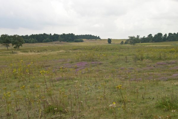
The Northern Lincolnshire Edge with Coversands National Character Area (NCA) comprises a ridge of Jurassic limestone running north from Lincoln to the Humber Estuary. The scarp slope rises prominently from adjacent low-lying land, forming the Edge or Cliff, and giving panoramic views out, in particular to the west. In the north is a second, lower scarp of ironstone. In the vicinity of Scunthorpe are the Coversands, post-glacial wind-blown sands which have given rise to mosaics of heathland, acid grassland and oak/birch woodland, supporting rare plant and animal communities akin to the Brecklands. Risby Warren, historically used as a rabbit warren, reveals the distinctive formation of inland dunes. Several of these sandy sites are designated as Sites of Special Scientific Interest, along with a number of disused limestone, ironstone and sand extraction sites, which comprise geological exposures alongside calcareous grassland, open water and other semi-natural habitats. At the northern boundary the limestone drops below the River Humber.
The soils of the limestone plateau are of good agricultural quality and support the cultivation of cereals, oilseeds, root crops and potatoes, along with pig and poultry rearing. Farmsteads of large buildings and sheltering copses are dispersed along the plateau, where there is a sense of openness with large fields and tightly clipped hedges. There are more woodlands in the north of the area, on the sandy soils east of Scunthorpe and on the scarp slopes in the west, and more mixed farming on the lower-lying land to the west, along with further woodlands on sandy deposits. Land on the lower dip slope to the east has been drained and is now productive farmland with fields bounded by ditches.
Ermine Street, a key Roman route from Lincoln to a crossing point on the Humber, follows the higher, drier land of the limestone plateau. Built in Norman times, the magnificent Lincoln Cathedral occupies a commanding position on top of the Edge, and is visible from far around. Exploiting the local ironstone and limestone, a steel making industry developed at Scunthorpe, along with associated engineering and manufacturing. First World War airfields are a feature along the top of the scarp, with RAF Scampton still active and home to the Red Arrows, while other airfields are now used for agriculture or industry and retail.
The Edge forms a watershed between the major catchments of the Trent and Ancholme, both of which flow into the Humber, and the Witham, which flows into The Wash. There is a principal aquifer within the underlying limestone, so that the protection of water quality and improvement of water availability are key issues. While the majority of soils are good quality, they can be prone to erosion, so that measures need to be taken to improve their structure and reduce sediment run-off. The formations and habitats of the Coversands are significant landscape features, and there are opportunities to extend the mosaics of heathland, grassland and woodland.
Headline Statements of Environmental Opportunity (SEO)
See the Statements of Environmental Opportunity section for more details on the headlines listed below.
SEO 1
On the limestone plateau, manage the high-quality farmland and maintain agricultural productivity, establishing networks of linking habitats to strengthen landscape character and enhance biodiversity, especially farmland birds, while also protecting the underlying aquifer, reducing soil erosion and improving soil and water quality.
SEO 2
On the sandy soils of the Coversands, protect the distinctive dune formations and expand, buffer and connect the key habitats, providing access and interpretation where possible, and addressing climate regulation, soil erosion and water availability.
SEO 3
Maintain the sense of place and the diversity of settlements and landscape features through expanding semi-natural habitats, managing the restoration of extraction sites, retaining the inspirational long views, ensuring that development is sustainable and well integrated into the landscape, and providing more interpretation and access through good green infrastructure links.
SEO 4
Protect and manage sites and features of historic, geological and geomorphological interest, such as sand dune formations and rock exposures, Roman roads, stone walls and vernacular architecture, and Lincoln’s historic centre, to strengthen sense of place and history, enhance biodiversity and improve understanding of how the landscape has developed over time.