

National Character Area 56
Lancashire Coal Measures - Analysis: Ecosystem Services
Analysis supporting Statements of Environmental Opportunity
The following analysis section focuses on a selection of the key provisioning, regulating and cultural ecosystem goods and services for this NCA. These are underpinned by supporting services such as photosynthesis, nutrient cycling, soil formation and evapo-transpiration. Supporting services perform an essential role in ensuring the availability of all ecosystem services.
Bodiversity and geodiversity are crucial in supporting the full range of ecosystem services provided by this landscape. Wildlife and geologically-rich landscapes are also of cultural value and are included in this section of the analysis. This analysis shows the projected impact of Statements of Environmental Opportunity on the value of nominated ecosystem services within this landscape.
Further analysis on landscape attributes and opportunities for this NCA is contained in the Analysis: Landscape Attributes & Opportunities section.
Natural Capital
Further information on Natural Capital within this NCA is contained in the Natural Capital and Key Ecosystem Services section.
The Lancashire Coal Measures NCA provides a wide range of benefits to society. Each is derived from the attributes and processes (both natural and cultural features) within the area. These benefits are realised through the ‘ecosystem services’ that flow from the ‘ecosystem assets’ or ‘natural capital’ of a place.
Natural capital means ‘the elements of nature that directly or indirectly produce value to people, including ecosystems, species, freshwater, land, minerals, the air and oceans, as well as natural processes and functions’ (Natural Capital Committee, 2017).
Ecosystem Services Main Beneficiaries
The below map displays the main beneficiaries of each ecosystem service identified within this NCA and neighbouring NCAs. These range from being of international importance to local importance. Some services have not been assessed within all NCAs, and therefore in some NCAs are displayed as “N/A” (not applicable).
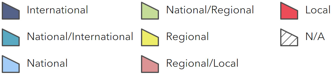
Main Beneficiaries Map
View Main Beneficiaries Map full screen in a new tab View Interactive Map HelpEcosystem service analysis
The following sections show the analysis used to determine key Ecosystem Service opportunities within the area. These opportunities have been combined with the analysis of landscape opportunities to create Statements of Environmental Opportunity. Please note that the following analysis is based upon available data and current understanding of ecosystem services. It does not represent a comprehensive local assessment. Quality and quantity of data for each service is variable locally and many of the services listed are not yet fully researched or understood. Therefore analysis and opportunities may change upon publication of further evidence and better understanding of the inter-relationship between services at a local level.
Note that numbers and figures in the body of the text are based on the 2014 profiles, unless otherwise stated.
Provisioning Services
Food provision
Assets/attributes: main contributors to service –
- Mixed arable, lowland grazing livestock and dairy
- Specialist poultry
- Horticulture soils
State – The predominant grades of agricultural land are Grade 2 (5 per cent), Grade 3 (57 per cent), and Grade 4 (3 per cent).
Main farm types are cereals holdings (26 per cent), lowland grazing livestock holdings (20 per cent), dairy holdings (7 per cent), mixed holdings (6 per cent), general cropping holdings (6 per cent), specialist poultry holdings (3 per cent) and horticulture holdings (3 per cent).
Nearly a third of holdings (29 per cent) are classed as ‘other’ which includes holdings with only horses, with only grass, or fodder crops or with only fallow land or buildings, and holdings with unknown activity
Main beneficiary – Local
Analysis – Food production remains an important service to the area. However, 33 per cent of the NCA is developed and development pressure is continuing, which is reducing land available for food production, particularly around the towns, villages and urban fringe.
Mining subsidence has impacted on drainage of agricultural land and many areas are not fully utilised for food production but are developing as valuable wildlife habitats.
Numbers of cattle, sheep and dairy have declined in recent years.
On mixed farms there has been some diversification of crop/cereal production and specialised poultry units have been introduced.
Remaining farmland is often fragmented, and in small pockets between settlements and industry. There may be opportunities to bring sustainable food production back into some areas, improving sense of place and the quality of the landscape.
Good farm management and animal husbandry practices can help to reduce soil erosion and regulate run-off, and improve soil quality.
Opportunities – Encourage good agricultural management of remaining farmland for food production and grazing to improve its long term viability.
Work with the local farming community to seek opportunities and consider how food production can be managed sustainably in urban fringe and marginal areas.
Explore and promote the marketing of quality local produce to nearby extensive urban populations.
Principal services offered by opportunities –
- Food provision
- Biodiversity
- Sense of place/inspiration
- Regulating soil erosion
- Regulating soil quality
- Regulating water flow
Timber provision
Assets/attributes: main contributors to service –
- Broadleaved woodland
State – 3,498 ha (9 per cent) of the total area is woodland.
2,810 ha (80 per cent) of the woodlands are broadleaved, 93 ha (3 per cent) are conifer and 198 ha (6 per cent) are mixed. There are 174 ha of ancient semi-natural woodland and 7 ha of plantations on ancient woodland sites (PAWS).
The Red Rose and the Mersey Community Forests cover 87 per cent of the NCA.
Main beneficiary – Local
Analysis – Across most of the area, woodland cover is very limited except to the north and west of Wigan (where the undulating land form and small scattered woodlands and hedgerow trees provide a greater sense of enclosure).
There are opportunities for woodland creation.
Increasing woodland cover in suitable locations and improving management of existing woodlands would provide opportunities to create innovative woodfuel, timber and forest industries. This is beneficial for mitigating climate change as well as providing improved sense of place and more habitats for wildlife and recreational use, and can also assist with assimilating new development into the landscape.
Opportunities – Encourage the appropriate management of existing woodlands and create new woodlands for multi-purpose use as part of the Community Forest initiative including innovative woodfuel, timber and forest industries, and enhancement of recreation, landscape and biodiversity interests, benefits for water quality, soil quality and flood risk management.
Ensure that new woodlands and hedgerow trees are planted to enhance the local landscape character in terms of typical scale, type and location and avoid impacting on existing features of historic interest or isolated semi-natural habitats.
Principal services offered by opportunities –
- Timber provision
- Sense of place/inspiration
- Biodiversity
- Recreation
- Biomass energy
Water availability
Assets/attributes: main contributors to service –
- Rivers
- Flashes
State – In the north, the Douglas catchment has ‘water available’ with the exception of the upper reaches of the Douglas north of Wigan and west of Horwich which have ‘no water available’.
The Wigan Flashes which are a series of wetland sites important for their biodiversity and amenity value are not thought to be adversely affected by abstraction.
In the south, tributary streams of the Mersey have ‘water available’ with the exception of the West Sankey unit in the area of St Helens and Prescot, which has ‘no water available’.
Main beneficiary – Local
Analysis – Across the NCA, abstracted water is used for industry, agriculture and public water supply although in the south this is abstracted from groundwater due to water quality issues with surface waters (The Lower Mersey and Alt Catchment Abstraction Management Strategy, Environment Agency, March 2008).
Establishing land management practices that improve infiltration and storing surface water run-off should be encouraged. Urban and developed areas contribute to these problems.
It is important to minimise compaction and/or capping risk on wet soils, which can arise from over-grazing, trafficking or other mechanised activities. These will tend to exacerbate run-off problems as well as damaging soil structure.
Increasing water availability and improving the management of abstraction in areas such as the Wigan Flashes is likely to increase wetland biodiversity and improve habitat quality in these and other areas.
Opportunities – Plan to manage over-abstraction from groundwater and rivers through careful and efficient use of water.
Encourage opportunities to work with land owners and managers to sustainably manage pastures to improve water infiltration and slow down water run-off, as well as ensure water quality is protected.
Encourage opportunities to work with land owners and managers to sustainably manage arable field and field margins, to improve infiltration and reduce soil erosion.
Encourage and promote opportunities to ensure grassland and wetland habitats, especially those within developed areas are under good environmental management, increasing their capacity to retain water, reduce run- off and improve water infiltration.
Principal services offered by opportunities –
- Water availability
- Regulating water quality
- Regulating soil erosion
- Biodiversity
Genetic diversity
No information available.
Biomass energy
Assets/attributes: main contributors to service –
- Broadleaved woodland
- Red Rose and Mersey Community
- Forest Initiatives
State – Existing woodland cover (9 per cent).
There are 15 woodfuel boilers and 1 woodfuel supplier.
For information on the potential landscape impacts of biomass plantings within the NCA, refer to the tables on the Natural England website.
Main beneficiary – Regional
Analysis – The potential yield for short rotation coppice (SRC) is high across the north of the NCA, medium in the south and low in the middle. The potential for miscanthus yield is high.
Increased provision of SRC and miscanthus as a source of renewable energy could contribute towards addressing climate regulation, but could also decrease provision of food if grown on farmland. There may be degraded and scattered parcels of land that are not suitable for agriculture such as spoil heaps and closed landfill sites, which would be suitable for planting.
Major expansion could also affect the sense of place if SRC and miscanthus became a major component of the landscape because the use of existing land is dominated by housing, industrial development and farming.
Although existing woodland provides only limited scope for woodfuel biomass, there is potential from urban tree management and new woodlands for local small scale woodfuel heat. The use of locally grown woodfuel for heating provides a resource efficient way of reducing reliance on fossil fuels.
Appropriately managed woodlands within the Community Forests offer a significant resource for woodfuel. Adjacent urban settlements and industry provide a potentially high local demand for biomass energy such as for wood-fired boilers.
Opportunities – Seek opportunities for new short rotation coppice and miscanthus planting and biomass production in appropriate locations, including small parcels of land isolated by development that are not suitable for agriculture such as spoil heaps and closed landfill sites.
Seek opportunities to encourage sustainable management of existing woodlands in appropriate locations to produce surplus timber and biomass for local use, for example for wood fired boilers.
Promote opportunities to establish new woodlands where appropriate, especially on reclaimed or restored land to supply locally grown woodfuel.
Principal services offered by opportunities –
- Biomass energy
- Biodiversity
Regulating Services
Climate regulation
Assets/attributes: main contributors to service –
- Existing woodland
- Existing wetland
- Soils
State – Carbon storage is also provided by the woodland within the NCA (9 per cent of the NCA).
Lowland raised bog (126 ha).
In this NCA, soil carbon levels are generally low (mainly 0-5 per cent carbon with areas of 5-10 per cent), reflecting the 93 per cent coverage of the NCA’s area with mineral soils, which can be low in organic content.
A few very small areas of higher carbon content occur in the north-east (20-50 per cent), likely to be associated with the NCA’s naturally wet very acid sandy and loamy soils (3 per cent of NCA) and its loamy and clayey floodplain soils with naturally high groundwater (1 per cent of NCA). These soils can provide a rich store of carbon.
Main beneficiary – Local
Analysis – Carbon storage within this NCA is provided by woodland, small areas of soils with higher carbon content, and pockets of lowland raised bog habitat. These habitats should be protected, managed and enhanced and expanded where possible. Areas of other wetland habitats could also be expanded where possible and appropriate.
The slowly permeable, seasonally wet, slightly acid but base-rich loamy and clayey soils and the slowly permeable, seasonally wet, acid loamy and clayey soils may both have potential for improved carbon sequestration by increasing organic matter content, introducing low input grassland management systems and converting to grassland or woodland.
Soils can be managed through sustainable agricultural practices to protect and bind the soil (such as the management of hedgerows, good grazing regimes and minimal tillage where soils are suitable) to help them retain their soil carbon levels.
Opportunities – Encourage the management and enhancement of areas of lowland raised bog to increase their ability to actively store and sequester carbon.
Seek opportunities to extend areas of wetland and wet grassland along rivers and in valley bottoms.
Seek opportunities to increase the carbon storage potential of the area through the management of woodlands and the planting of new woodland where appropriate.
Encourage the introduction and adoption of low input grassland management to promote carbon sequestration, such as the creation of grassland buffer strips in arable areas and restoration of permanent grassland through reclamation works.
Principal services offered by opportunities –
- Climate regulation
- Regulating water flow
- Regulating water quality
- Regulating soil quality
- Biodiversity
Regulating coastal erosion and flooding
No information available.
Regulating water quality
Assets/attributes: main contributors to service –
- Rivers and canals
- Semi-natural habitats
State – For information regarding the current state of water quality within this NCA, refer to the Environment Agency (Draft river basin management plan maps).
Main beneficiary – Regional
Analysis – Improvements could be made to water quality through selective reduction in inputs from point source pollution and diffuse pollution.
On agricultural land this might be achieved through the introduction of improved land management practices, such as the buffering of water courses to address specific pollutant issues, altering the timing of fertiliser and manure applications to grassland and restricting livestock access to streams and rivers.
Due to the large urban and industrial areas of the NCA, water runoff can contain pollutants and chemicals which enter into the waterways. Sustainable urban drainage systems, which can include swales and porous surfaces, can be introduced in urban areas to improve water quality.
Woodland cover can stabilise contaminated brownfield land.
There are some issues with minewater rebound and there are currently treatment schemes in operation at Hindley Deep Pit and Quakerhouse Colliery.
Other specific pollutants in the area include waste calcium sulphate from the glass industry, leachate from landfill sites, and other contaminants from the heavy industrialised areas.
Opportunities – Promote and work with farmers to encourage adoption of improved land management to address water quality issues across river catchments, in particular through the creation of grassland buffer strips alongside watercourses and restricting livestock access to watercourses.
Seek opportunities to manage and expand wetland habitats adjacent to watercourses, such as reedbeds that help to filter water.
Promote opportunities to develop sustainable urban drainage systems (SUDS) in new development to improving infiltration and water quality.
Encourage restoration of mineral spoil heaps to reduce run off and pollution sources.
Principal services offered by opportunities –
- Regulating water quality
- Biodiversity
- Regulating water flow
- Regulating soil erosion
- Regulating soil quality
Regulating water flow
Assets/attributes: main contributors to service –
- Woodland
- Wetlands
- Other semi natural habitats
- Rivers
- Canals
State – The principal river within the NCA is a section of the River Douglas, which flows on to the Lancashire and Amounderness Plain NCA. The River Douglas also serves to connect the Leeds and Liverpool Canal, which passes through the NCA, to the sea.
The main area of fluvial flood risk within the NCA is in Wigan (on the River Douglas), with Horwich and Appley Bridge also at risk from upper sections of the Douglas.
There is also flood risk from the Leeds and Liverpool Canal in some places where it is above the level of the surrounding properties.
The Environment Agency’s preferred approach to managing these risks includes investigating alternative sustainable flood risk measures for Appley Bridge (such as the extension of a current temporary scheme to divert a brook to a local quarry for storage) and encouraging the use of appropriately designed sustainable urban drainage systems (SUDS) to control run-off at source.
In the southern part of the NCA, fluvial flood risk also exists from tributaries of the River Mersey. The principal settlements affected are St Helens and Ashton-in- Makerfield (from Sankey Brook) and Leigh, Hindley Atherton and Westhoughton (from Glaze Brook) (River Douglas Catchment Flood Management Plan Summary Report, Environment Agency, 2009; Mersey Estuary Catchment Flood Management Plan Summary Report, Environment Agency, 2009).
Main beneficiary – Regional
Analysis – Original drainage is disturbed in many areas from mining subsidence and urban development, and watercourses are heavily modified with flood risks downstream both within and beyond the NCA.
Land management which increases vegetation cover can slow flood flows, due to increased roughness, infiltration and evapo-transpiration.
The River Douglas rises in the higher rainfall area of the west Pennines where reservoirs and water management affect flow, but levels can rise quickly. There is some potential for increasing water storage and regulating flows in floodplains and farmland, but action is also needed in upland areas outside the NCA.
The slowly permeable, seasonally wet, slightly acid but base-rich loamy and clayey soils and the slowly permeable, seasonally wet, acid loamy and clayey soils will tend to have poor water infiltration with potential for rapid water run-off, especially on sloping land, due to clay subsurface layers.
Flash flooding and subsequent run off can be exacerbated by the extensive hard surfaces of urban and industrial areas. Use of SUDS in development can increase water infiltration, to slow surface water run-off.
Opportunities – Promote opportunities to increase water storage and alleviate speed of run-off through the expansion of wetlands and other habitats such as reedbeds and wet woodland in floodplains.
Seek opportunities to extend and manage areas of floodplain, introducing permanent grassland, woodland and wet pastures to improve soil quality and water retention, especially on reclaimed land.
Investigate opportunities for alternative sustainable flood risk measures, such as SUDS.
Seek opportunities to increase urban greenspace to aid interception and infiltration of rainfall and slow run-off into the rivers.
Principal services offered by opportunities –
- Regulating water flow
- Regulating water quality
- Water availability
- Regulating soil quality
- Regulating soil erosion
- Biodiversity
Regulating soil quality
Assets/attributes: main contributors to service –
- Soils
- Geology
State – This NCA has 8 main soilscape types. 2 key soil types cover 81 per cent of the NCA. The slowly permeable seasonally wet slightly acid but base-rich loamy and clayey soils (45 per cent) and the slowly permeable seasonally wet acid loamy and clayey soils (36 per cent).
Main beneficiary – Regional
Analysis – Soils may suffer compaction and/or capping as they are easily damaged when wet. In turn this may lead to increasingly poor water infiltration and diffuse pollution as a result of surface water run-off.
Adjusting management of the slowly permeable seasonally wet slightly acid but base-rich loamy and clayey soils to encourage the build up of organic matter will improve overall soil structure and aid water infiltration.
Slowly permeable, seasonally wet, acid loamy and clayey soils are easily damaged when wet or after heavy rain. It is important to minimise compaction and/or capping risk on wet soils, which can arise from over-grazing, trafficking or other mechanised activities. Management measures that increase organic matter levels and maintain good vegetation cover will help to alleviate problems such as poor water infiltration and diffuse pollution.
There are some areas of restored soils mostly from quarry and opencast spoil (4 per cent).
Opportunities – Encourage sound land management practices which minimise/reduce negative impacts of soil structural deterioration for example careful planning of cultivations, minimum tillage techniques on arable land, appropriate stocking densities and extensive grazing, and recreational management techniques to avoid compaction, poaching or puddling of soils.
Encourage management practices to build up organic matter levels where low in soils under arable cultivation and permanent grassland.
Encourage restoration of permanent grassland or pasture where appropriate.
Avoid carrying out mechanised activities such as trafficking that will cause compaction of soils, especially in wet conditions.
Seek opportunities to manage reclaimed and restored mineral soils in appropriate areas.
Principal services offered by opportunities –
- Regulating soil quality
- Regulating water quality
- Regulating water flow
- Regulating soil erosion
Regulating soil erosion
Assets/attributes: main contributors to service –
- Semi-natural vegetation cover
- Woodland
- Slowly permeable soil types (82 per cent)
State – The soils covering 82 per cent of this NCA, notably slowly permeable soil types, are not susceptible to erosion.
Soils in this NCA at risk from erosion issues include: freely draining slightly acid loamy soils (1 per cent); freely draining slightly acid sandy soils (5 per cent); naturally wet very acid sandy and loamy soils (3 per cent); restored soils mostly from quarry and opencast spoil (4 per cent); slightly acid loamy and clayey soils with impeded drainage (2 per cent).
Main beneficiary – Local
Analysis – The freely draining, slightly acid, loamy soils and the freely draining, slightly acid, sandy soils are prone to erosion especially where vegetation is removed or where organic matter levels are low after continuous cultivation. The naturally wet very acid sandy and loamy soils can also be prone to erosion if heavily trafficked or after heavy rain. All of these soil types are light and at risk of wind erosion, especially where coarse textured (freely draining slightly acid loamy soils), cultivated or left bare.
The slightly acid loamy and clayey soils with impeded drainage are easily compacted by machinery or livestock if accessed when wet and are prone to capping or slaking, increasing the risks
of soil erosion by surface water run-off, especially on steeper slopes.
It is important to minimise compaction and/or capping risk on wet soils, which can arise from over-grazing, trafficking or other mechanised activities. This will reduce soil erosion as well as improve soil structure and run-off problems.
Management of the freely draining soils to encourage the build up of organic matter will not only reduce erosion problems, but will also improve soil structure and aid water infiltration.
Appropriately managing woodland and grassland, particularly on steeper slopes and near watercourses, will also reduce the risk of soil erosion.
The restored soils mostly from quarry and opencast spoil are highly variable and often compacted with an absence of top soil and organic matter which can make them difficult to manage. Rainfall cannot infiltrate, and they are often subject to drought in summer and very wet in winter. They are susceptible to erosion from surface run-off especially on steeper slopes.
Opportunities – Seek opportunities to manage, protect and increase areas of woodland and permanent grassland especially on steeper slopes and on reclaimed mineral soils in appropriate areas.
Encourage opportunities to manage pastures in ways that build up organic matter and avoid compaction, for example by reducing grazing pressures, thus slowing down run-off.
Manage and enhance riparian habitats to reduce soil erosion rates and trap soils before they enter into the streams.
Encourage restoration and management of ‘gappy’ hedgerows in poor condition to act as a wind break and bind/filter out the soil in times of flood.
Promote and encourage the introduction of field margins, grass buffer strips and winter stubble alongside watercourses to trap sediment.
Principal services offered by opportunities –
- Regulating soil erosion
- Regulating soil quality
- Regulating water quality
- Regulating water flow
- Biodiversity
Pollination
Assets/attributes: main contributors to service –
- Areas of semi-natural habitats
- General cropping holdings (7 per cent), horticulture holdings (3 per cent) of farmland
State – Some holdings are farmed for general crops and horticulture.
Arable field margins are a valuable habitat for a range of wild flower species.
Uncultivated field margins form a linear habitat particularly valuable for both food and wildlife cover.
Main beneficiary – Local
Analysis – Natural pollination is beneficial to some crops including horticulture.
Semi-natural habitats are scattered and dispersed across the landscape. Increases in semi-natural habitats would provide corridors and habitats for pollinators.
Arable field margins are fragmented but important for pollination. Better management, expansion of margins and the introduction of buffer strips in cropped areas would benefit pollination and wildlife.
Improvements to grass margins, hedgerow management, road verges, river corridors and other suitable locations could provide improved nectar sources.
Opportunities – Seek opportunities to introduce pollen and nectar strips, margins and buffer strips alongside watercourses and within the agricultural landscape, to encourage and support pollinating insects.
Encourage and promote opportunities to expand permanent grassland and/or improve areas of species-rich grassland.
Manage and enhance the diversity and extent of hedgerows and their margins.
Seek and manage opportunities to improve road verge, parks and urban greenspace management so that they provide greater nectar sources.
Seek opportunities to link areas of scattered semi-natural habitats and provide wildlife corridors through introduction of green infrastructure projects within new development.
Principal services offered by opportunities –
- Pollination
- Biodiversity
Pest regulation
No information available.
Cultural Services
Sense of place/inspiration
Assets/attributes: main contributors to service –
- Varied topography of gentle hills and valleys
- Densely populated scattered settlement pattern
- Long history and legacy of mining and heavy industry
- Wetlands
- Open arable farmland to the north of St Helens
- More wooded character to the north-west of Wigan
State – A fragmented landscape created by a complex pattern of mining and industrial activity intermixed with housing and urban areas set within a gentle but varied topography.
Although much of the NCA is still agricultural, its character is strongly influenced by past mining activity, industry, urban/housing areas, and the significant transport infrastructure, leading to an interesting urban and semi-rural mix.
The area is dominated by a legacy of mineral extraction; derelict and reclaimed mineral workings, particularly around Wigan and St Helens.
Past mining activity has created a number of subsidence flashes which now provide important wetland habitats including open water, fen, swamp and grasslands.
Main beneficiary – Regional
Analysis – The complex pattern of dense settlement and past land uses, notably mining, has created a very fragmented landscape strongly linked to its mining and industrial heritage.
There has been development of a significant transport infrastructure (road and rail).
Sites of nature conservation interest have formed on many former industrial sites and are bringing nature back into the urban fabric. Sites such as the Wigan Flashes are popular with nearby residents for recreation and relaxation.
There is strong cultural association with the past mining history and local identity is often related to individual pits and workings. Land reclamation and restoration needs to strengthen and enhance landscape character, still retaining some evidence of the industrial heritage.
The mix of urban and rural is important to help retain local identity of developments and to help maintain access to open space.
There are examples where cultural heritage of the area is promoted, such as in Bold Forest Park, where the Sutton Manor Colliery closed in 1991 but has been transformed into community woodland, including the landmark sculpture ‘Dream’.
Whilst most of the colliery waste sites have been transformed for example into community woodlands or country parks, they are not integrated into the surrounding landscape and can appear to be imposed upon it. Community woodlands can form a setting for communities to engage with culture, heritage and the arts.
Billinge Hill is a dominant landscape feature between St Helens and Wigan and has great cultural, recreational and heritage significance to the community.
Opportunities – Seek opportunities to protect, increase awareness of and interpret the industrial heritage and features of the NCA.
Encourage farmers and land owners to conserve and enhance the patchwork of landscape features and, habitats and heritage features within the NCA. For example, manage and restore hedgerows to enhance farmed landscape, link habitats and improve green infrastructure for visual and recreational benefit.
Seek opportunities to encourage urban communities to engage with the natural environment.
Improve the urban-rural fringe through careful design and integration of green infrastructure with housing and industry, linking new developments with the wider countryside and assisting with assimilating new development into the landscape.
Consider how restored colliery waste sites might be better integrated into the wider landscape, for example through tree and hedge planting that links with local patterns of hedgerows and woodlands.
Maintain visibility and views from the summit of Billinge Hill, as well as conserving and promoting the heritage of this important feature.
Principal services offered by opportunities –
- Sense of place/inspiration
- Sense of history
- Recreation
- Biodiversity
Sense of history
Assets/attributes: main contributors to service –
- Historic industrial/mining infrastructure including derelict colliery buildings, spoil heaps
- Peat deposits
- 5 Registered Parks and Gardens
- 29 Scheduled Monuments
- 743 Listed Buildings
- Traditional churches and red-brick terraces
State – The history of the landscape is evident from the area’s strong cultural identity and links to heavy industry as well as coal mining.
Little evidence of the pre-18th century landscape remains.
Earlier settlement patterns are obscured by later developments but may be spotted in the old village cores visible in the distribution of churches, moated sites and place names with the element ‘green’.
The older farming regimes are characterised by dispersed and loose courtyard farmsteads, typically dating from 18th and 19th centuries and with 2-storey combination barns.
Coal mining, glass and copper production combined with diverse manufacturing has led to a densely settled landscape of traditional red-brick terraces, and in some areas local sandstones.
Historic buildings and sites evident to the general public include the Hulton, Taylor and Mesnes Parks, Knowsley Hall and Borough Cemetery, St Helens, as well as the area’s traditional buildings such as its churches and red-brick terraces.
Main beneficiary – Regional
Analysis – There is a strong connection between geology and the industrial heritage, linking coal mining and the underlying Coal Measures.
There are examples of historic industrial buildings such as at the Wigan Pier complex and Trencherfield Mill.
Increasing the sense of history has the potential to increase the sense of place. This could in turn lead to an increase in biodiversity and create recreational opportunities by reinforcing the historic character of the landscape.
Areas of peat, including lowland raised bog, have the potential to preserve organic remains including pollen. As peat dries out, the organic resource will deteriorate, leading to degradation in the archaeological resource. Sympathetic management of areas with surviving peat should prevent this.
Opportunities – Seek ways to protect, conserve, manage and interpret the area’s historic and cultural identity, in particular the town parks and greenspace, historic village cores, traditional buildings and farmsteads, industrial features, and the area’s coal mining heritage to ensure a better understanding of past land use and retain evidence of the relationships between features for the future.
Encourage opportunities to use the public rights of way and access network to allow communities to gain access to, reveal, interpret and enjoy the area’s rich history.
Raise awareness and increase understanding of the local history of the area and the importance of this at a national level.
Sympathetically manage areas with potentially high archaeological resource.
Principal services offered by opportunities –
- Sense of history
- Sense of place/inspiration
- Recreation
- Geodiversity
Tranquility
Assets/attributes: main contributors to service –
- Woodlands Wigan ‘flashes’
- Rivers
- Agricultural land
- Parks, gardens and urban greenspace
State – The amount of the NCA classified as ‘undisturbed’ has decreased from just over 15 per cent in the 1960s to 0.5 per cent in 2007.
The area of greatest tranquillity is associated with the pockets of woodland and smaller settlements to the north-west of Wigan around Appley Bridge and Horrock Hill.
The NCA has high levels of intrusion from urban / housing development, industry and noise, in particular it being a communications hub (M6, M61, M58, A580, mainline railways) and part of the new town of Skelmersdale.
Main beneficiary – Local
Analysis – This NCA has experienced a significant reduction in tranquillity and undisturbed areas.
Despite the overall low levels of tranquillity within this NCA, the parks, woodlands, urban green space, subsidence flashes and new reclaimed landscapes of mineral workings are an important source of perceived tranquillity in the local area and are highly valued for the relative tranquillity they provide.
Providing increased opportunities and access to a tranquil environment through management, enhancement and expansion of existing and new woodlands and habitats will help to ease the pressure and reduce numbers at current key sites to ensure that they can remain tranquil and contribute to biodiversity, sense of place and recreation and improve local health and wellbeing.
Opportunities – Seek opportunities to protect and enhance remaining areas of undisturbed or less disturbed land from inappropriate development.
Encourage opportunities to improve, maintain and expand habitats such as woodlands and wetlands which may increase the sense of tranquillity in the urban fringes, for example, by planting woodlands and shelter belts and ensuring any new developments are sensitively designed to reduce visual and infrastructure impacts.
The Red Rose and the Mersey Community Forests provide opportunities to increase woodland and other habitats, to create tranquil areas for people to enjoy.
There are opportunities for regeneration and mineral reclamation projects and new housing or industrial developments to provide quiet enjoyment through additional managed green spaces for people.
Principal services offered by opportunities –
- Tranquillity
- Sense of place/inspiration
- Recreation
- Biodiversity
Recreation
Assets/attributes: main contributors to service –
- Network of footpaths
- Open access land
- Mersey and Red Rose Community Forests
- Flashes and water bodies
- Country parks
- Local Nature Reserves
- Registered Parks and Gardens
State – 805 km public rights of way (density of nearly 2 km per km), cycle routes, together with open access land (550 ha), public forest estate (446 ha), country parks (513 ha), Local Nature Reserves (382 ha) and 5 Registered Parks and Gardens provides recreational access and facilities for quiet enjoyment.
This is supported significantly by the initiatives of the Mersey and Red Rose Forests, both Community Forests which cover just less than 88 per cent of the NCA.
Main beneficiary – Local
Analysis – Only 6 per cent of the Lancashire Coal Measures is classified as being publically accessible. There are large populations locally both within the many towns of the Lancashire Coal Measures and the two adjacent conurbations.
Communities value their local greenspaces as places of local distinctiveness that provide opportunities to engage with nature close to where they live and work to improve physical and mental health and encourage a sense of community.
While the extent of open access land is limited, the large population within the Lancashire Coal Measures has access to many public rights of way, as well as Community Forest areas, country parks, Local Nature Reserves, and urban greenspaces. These are being linked to the developing recreational potential of the flashes, water bodies and significant areas of reclaimed mineral workings and old railway lines which are providing a new and emerging network of open space. Similarly, the canal network is used for coarse fishing as well as recreational boating, while the towpath is used for walking, cycling and horse riding on some sections of the Leeds and Liverpool Canal.
New recreational opportunities could be developed in some areas enabling people to enjoy the natural environment sustainably without significant effects on other services.
Local woodlands and the two community forests have generated local interest to increase woodland habitats, create wildlife corridors and access for people.
Opportunities – Seek opportunities to improve access by ensuring that paths are maintained and well signposted, creating new/circular routes, and some surfaced paths suitable for all levels of ability and interest at key locations.
Seek opportunities to provide increased access to green spaces, especially within urban areas, new developments and urban fringe so communities can connect with their local green spaces.
Seek opportunities to increase recreation provision through access to and interpretation of historical mineral and industrial sites and their restoration.
Provide interpretation of the landscape, its history and its features.
Principal services offered by opportunities –
- Recreation
- Sense of place/inspiration
- Sense of history
- Biodiversity
- Geodiversity
Biodiversity
Assets/attributes: main contributors to service –
- Semi-natural habitats
- Sites of Special Scientific Interest (SSSI) and Local Wildlife Sites
- Flashes, wetlands and ponds
- Rivers Species
State – The NCA has a limited extent of biodiversity priority habitats, the most significant being; small areas of lowland raised bog, purple moor grass and rush pasture, lowland meadows, reedbeds, lowland dry acid grassland and broadleaved, mixed and yew woodland (broad habitat).
It contains no internationally designated sites and only 200 ha are nationally designated as SSSI.
There are 256 Local sites covering 2,673 ha (7 per cent of NCA).
Main beneficiary – Regional
Analysis – Designated sites make up only a small percentage of the NCA, however, conservation, management and enhancement of priority habitats outside of these areas is very important for biodiversity and nature conservation in the countryside and urban fringe.
Many habitats and species are of local conservation importance and require action in order to conserve them.
Conserving and enhancing the network of local wildlife sites, improving their biological condition through land management activities will also help species to adapt to climate change, link habitats and allow species movement to strengthen populations.
Highfield Moss SSSI is significant for its wet heath/mire and is the only site for marsh gentians in Lancashire, Greater Manchester, Cheshire, and Merseyside. Populations of water vole are found at many wetland sites such as Red Moss and the Wigan flashes. Management and enhancement of the subsidence wetlands is important for overwintering wildfowl, breeding birds including willow tit, bittern, gadwall and several species of dragonfly.
Conservation of field ponds is important to maintain breeding sites for amphibians, such as great crested newt. Ponds may also serve as habitat “stepping stones” assisting local wildlife migrations and increasing the variety of species on farmland and in urban areas.
There is a small, but important, ancient woodland resource.
Pockets of habitats are often fragmented by housing and industrial land use.
Post-industrial sites are developing into important habitats for wildlife.
Consideration should be given to surrounding areas to promote linking of habitats and populations to provide a more integrated approach, for example, managing and restoring field margins; providing buffers along watercourses; planting new woodlands; creating linear wildlife corridors along rivers, railways and roads; managing and extending green spaces within urban areas to improve connectivity.
Connectivity is important, particularly north-south as the area lies in a corridor between two major conurbations.
The urban fringe location of many species and habitats enables people to experience and enjoy biodiversity close to home at country parks, Local Nature Reserves and other local green spaces.
The improved management of arable farmland and grassland with its open fields, hedgerows, uncut grass and small woodlands would benefit brown hares and also provide year-round habitat for many arable and farmland birds.
Opportunities – Encourage improved management to bring and maintain priority habitats, into favourable condition.
Encourage opportunities to expand and extend habitats such as woodlands, wetlands and ponds.
Seek ways to manage land adjacent to the isolated pockets and linear habitats to ensure that they are protected, expanded, buffered and linked, to increase habitat connectivity and allow species movement especially along rivers, water bodies, road verges and ponds.
Encourage and seek local/ community opportunities to promote sustainable recreation, public understanding and enjoyment and educational opportunities linked to biodiversity.
Encourage improved management of arable farmland and grassland through increased uptake of environmental incentive schemes to provide a mixed landscape of open fields, well-managed hedgerows, mosaics of uncut grass, stubbles and margins and small woodlands to benefit species such as arable and farmland birds and brown hare.
Seek to protect the ancient woodland resource.
Seek to improve restoration of mineral sites and subsidence flashes, maintaining their water flow and quality to maximise their value to wildlife and biodiversity.
Encourage opportunities to incorporate green infrastructure projects into new developments especially on the urban fringe to enhance sense of place, recreational and biodiversity value and to make a positive contribution to health and well being.
Seek to restore hedges and hedgerow trees, establish woodland where appropriate and expand riparian planting along water courses.
Diversifying the landscape will support hare populations.
Principal services offered by opportunities –
- Biodiversity
- Sense of place/inspiration
- Regulating water quality
- Regulating water flow
- Recreation
Geodiversity
Assets/attributes: main contributors to service –
- Ravenhead Brickworks SSSI
- 45 Local Geological Sites
State – The Lancashire Coal Measures are mantled by a patchy layer of glacial deposits. The Upholland Ridge forms the western boundary to this area and is formed from an upstanding faulted slice of resistant Millstone Grit within the Coal Measures.
There is currently 1 nationally designated geological SSSI within the NCA and 45 Local Geological Sites.
Main beneficiary – Regional
Analysis – This NCA includes important sites for Carboniferous stratigraphy and fossils. The Lancashire Coal Measures contains once economically important coal seams used in local industries.
Geological sites provide important and often publicly accessible rock sections allowing the interpretation, understanding and continued research into the geodiversity of the NCA.
The successions at Ravenhead Brickworks SSSI are of vital importance to improve our understanding of the environment and the deposition of the Productive Coal Formation, not only within the Pennine Basin, but also within the UK as a whole.
The reclamation of mineral workings and restoration of extraction sites, spoil heaps and subsidence flashes, provides opportunities to link human activities with a sense of place and history while increasing habitats for wildlife.
Opportunities – Encourage and seek opportunities to maintain the diversity and integrity of geological and geomorphological features within the NCA link them to the history of the area and enhance their value for interpretation, education, recreation and visual amenity.
Encourage initiatives to improve public access to and understanding and enjoyment of the area’s geology.
Principal services offered by opportunities –
- Geodiversity
- Biodiversity
- Sense of place/inspiration
- Sense of history
- Recreation