

National Character Area 105
Forest of Dean and Lower Wye - Analysis: Ecosystem Services
Analysis supporting Statements of Environmental Opportunity
The following analysis section focuses on a selection of the key provisioning, regulating and cultural ecosystem goods and services for this NCA. These are underpinned by supporting services such as photosynthesis, nutrient cycling, soil formation and evapo-transpiration. Supporting services perform an essential role in ensuring the availability of all ecosystem services.
Bodiversity and geodiversity are crucial in supporting the full range of ecosystem services provided by this landscape. Wildlife and geologically-rich landscapes are also of cultural value and are included in this section of the analysis. This analysis shows the projected impact of Statements of Environmental Opportunity on the value of nominated ecosystem services within this landscape.
Further analysis on landscape attributes and opportunities for this NCA is contained in the Analysis: Landscape Attributes & Opportunities section.
Natural Capital
Further information on Natural Capital within this NCA is contained in the Natural Capital and Key Ecosystem Services section.
The Forest of Dean and Lower Wye Valley NCA provides a wide range of benefits to society. Each is derived from the attributes and processes (both natural and cultural features) within the area. These benefits are realised through the ‘ecosystem services’ that flow from the ‘ecosystem assets’ or ‘natural capital’ of a place.
Natural capital means ‘the elements of nature that directly or indirectly produce value to people, including ecosystems, species, freshwater, land, minerals, the air and oceans, as well as natural processes and functions’ (Natural Capital Committee, 2017).
Ecosystem Services Main Beneficiaries
The below map displays the main beneficiaries of each ecosystem service identified within this NCA and neighbouring NCAs. These range from being of international importance to local importance. Some services have not been assessed within all NCAs, and therefore in some NCAs are displayed as “N/A” (not applicable).
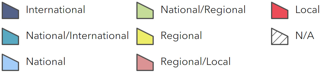
Main Beneficiaries Map
View Main Beneficiaries Map full screen in a new tab View Interactive Map HelpEcosystem service analysis
The following sections show the analysis used to determine key Ecosystem Service opportunities within the area. These opportunities have been combined with the analysis of landscape opportunities to create Statements of Environmental Opportunity. Please note that the following analysis is based upon available data and current understanding of ecosystem services. It does not represent a comprehensive local assessment. Quality and quantity of data for each service is variable locally and many of the services listed are not yet fully researched or understood. Therefore analysis and opportunities may change upon publication of further evidence and better understanding of the inter-relationship between services at a local level.
Note that numbers and figures in the body of the text are based on the 2014 profiles, unless otherwise stated.
Provisioning Services
Food provision
Assets/attributes: main contributors to service –
- Agri environment schemes
- Naturally fertile soils
- Water availability
State – The Forest of Dean and Lower Wye Valley supports a small amount of mixed farming, sheep dominate the livestock, there is just under 10,500 ha of grass or uncropped land and a small area, 2,000ha, laid to cereal. The area also provides a range of market gardening and produce from traditional orchards. The central forest also supplies an amount of venison and more recently, wild boar.
Main beneficiary – Local
Analysis – The statutory forest is currently under -grazed so there is scope to increase the livestock numbers in the area which would also benefit the biodiversity and some heritage features by maintaining open areas.
Traditional orchards are in decline, trees often not being replaced potentially resulting in the loss of local varieties. The sensitive restoration of traditional orchards could benefit local food production, biodiversity, culture and tourism.
Opportunities – Opportunity to work with local graziers to increase livestock numbers within the statutory forest.
Traditional orchards provide opportunity for high quality local produce, which could link in with tourism initiatives such as orchard history, tasting events, seasonal celebrations and walking routes.
Principal services offered by opportunities –
- Food provision
- Culture
- Biodiversity
- Sense of place/inspiration
- Sense of history
Timber provision
Assets/attributes: main contributors to service –
- Area of existing woodland
State – 40 percent of the area (12,918 ha) is woodland, much of the central plateaux is managed for timber production. Annual timber production from the Statutory Forest of Dean and Forestry Commission woodlands to the south of the Dean totals approximately 50,000 m3. Approximately 40,000 m3 conifer production split equally between felling & thinning with the remaining 10,000 m3 coming from broadleaved thinning. There is also in the region of an additional 20,000 m3 of timber production from private woodland (Figures supplied by the Forestry Commission).
Main beneficiary – National
Analysis – Due to the already extensive woodland cover there is little opportunity for expansion due to the impact it would have on valued open habitats and agricultural land, however the emphasis on the type of timber production could be altered. Species composition is approximately 37 percent conifer, 51 percent broadleaves, but for the period 2009 – 2028 the proportion of broadleaves in Forestry Commission managed woodlands is planned to increase by 1,000 ha through plantations on ancient woodland sites (PAWS) restoration and the replacement of conifers by broadleaves.
Overall tree cover has a positive impact on alleviating flooding as it slows the rate of water reaching the ground, enables water to permeate the soil and slows the flow of water across the land. Changes in management practice from clear fell to continuous cover should reduce runoff having a positive effect on reducing flooding and soil erosion.
However, the incidence of diseases such as red band needle blight affecting Corsican pine and Phytophthora which is now affecting larch in the Dean will result in an increase in felling that could adversely impact the incidence of flooding. Phytophthora also affects other species such as oak and sweet chestnut and together with other fungal diseases which thrive in the current damp summers may have a future impact on the species structure of the woodland.
Grey squirrel are a problem in the Forest of Dean where they have a detrimental effect on tree growth through bark stripping and impact the commercial value of the wood.
Opportunities – Increase the area of managed broadleaf woodland on Forestry Commission land through PAWS restoration and the replacement of conifers by broadleaves, planning and managing the woodland and open habitat network at a landscape scale.
Principal services offered by opportunities –
- Timber Provision
- Biomass energy
- Regulating soil erosion
- Climate regulation
- Regulating water flow
- Biodiversity
- Sense of place/inspiration
Water availability
Assets/attributes: main contributors to service –
- Abstraction
- The River Wye receives a high volume of fresh water from the extensive catchment including Welsh uplands
- High rainfall area
State – The main rivers in this NCA are the River Wye and the River Lyd while the Severn Estuary lies immediately to the east of the NCA, with east flowing streams flowing into the estuary. The NCA overlies an outcrop of sandstone, although around the central basin and under the central plateau are older rocks including limestones (Forest of Dean Character Area profile). Groundwater within all bedrock strata and drift deposits provides important baseflow support to surface water features especially during dry periods (The Wye Catchment Abstraction Management Strategy).
Main beneficiary – Regional
Analysis – Overall, most of the NCA is classed as having either ‘no water available’ for further abstraction or as ‘over licensed’. Groundwater within the area is classified as having ‘no water available’ (The Wye Catchment Abstraction Management Strategy) as are the waters of the Wye which is a main source of water for public water supply and agriculture. The area is subject to a ‘hands-off flow condition’ when water is scarce (Severn Vale Catchment Abstraction Management Strategy).
The Wye is of international importance as a SAC and maintenance of high spate flows and high base flows are essential to maintain its ecological importance, valued for its largely unmodified physical and undisturbed physical character (River Wye Core Management Plan (Special Area of Conservation) CCW, 2008). The rivers support resident brown trout and coarse fish populations, migratory eels and salmon and low flows are thought to be adversely affecting these fish populations, particularly spawning and nursery areas (Severn Vale Catchment Abstraction Management Strategy).
Measures to reduce abstraction by retaining more water on the land, both in this NCA and throughout the Wye catchment, through water storage reservoirs and semi-natural wetland habitat and better soil quality (increased permeability) can potentially alleviate dips in river flow.
Opportunities – Maintain ecological flow levels in water courses by managing abstraction so as to avoid over abstraction resulting in low flow levels.
Well designed winter water storage reservoirs on farms both within the NCA and across the Wye catchment could help alleviate the levels of abstraction for water used on farmland.
Slow the flow of water across the landscape to maintain more constant river levels through ponds, scrapes and more naturalised drainage within the NCA and across the Wye catchment. Hedgerows across steeper slopes will also help to slow the flow of water from the land.
Support measures to maintain and improve soil structure to increase permeability and water retention by the soil.
Principal services offered by opportunities –
- Water availability
- Food provision
- Biomass energy
- Regulating water flow
- Regulating water quality
- Regulating soil erosion
- Regulating soil quality
- Climate regulation
- Recreation
- Geodiversity
Genetic diversity
Assets/attributes: main contributors to service –
- Orchard fruit varieties
State – This and the surrounding NCAs of the major fruit producing counties of Gloucestershire Herefordshire and Worcestershire retain a wide range of local varieties of orchard fruit cultivated over hundreds of years.
Main beneficiary – National
Analysis – Genetic diversity of orchard fruit varieties are important to maintain in order to safeguard food provision, and afford increased resilience to climate change and disease. Examples of local varieties from this NCA include Evans’ Kernel, a general purpose apple variety from Ruardean; Blaisdon Red Plum which originated in the village of Blaisdon and was used for jam- making until the jam factories made use of freezing; Merrylegs pear, a variety found on the eastern fringe of the Forest of Dean, producing sweet tasting fruits.
Opportunities – Maintain county orchard variety collections such as the Perry pear collection at Hartpury, Gloucestershire.
Raise awareness of local varieties and link owners with suppliers.
Encourage regeneration and planting of local varieties.
Principal services offered by opportunities –
- Genetic diversity
- Climate regulation
- Pollination
- Biodiversity
- Sense of place/inspiration
- Sense of history
Biomass energy
Assets/attributes: main contributors to service –
- Coppiced woodland
State – This NCA has one of the highest woodland covers of any NCA, with woodland covering 40 percent of the area (of which 15 percent is coniferous).
Main beneficiary – Regional
Analysis – Currently the woodland is largely managed for timber production. Large areas of woodland were historically coppiced for charcoal production during the areas industrial past, much of this management has ceased but could be reinstated providing wood fuel and improved biodiversity habitat.
Opportunities – Significant opportunity for the production of biomass as a by-product of commercial timber operations and by bringing unmanaged and under managed woodland back into appropriate management. Reintroduction of coppicing may be appropriate in some sections.
Principal services offered by opportunities –
- Biomass energy
- Biodiversity
- Sense of place/inspiration
- Sense of history
Regulating Services
Climate regulation
Assets/attributes: main contributors to service –
- Extensive semi-natural and conifer woodland
- Extensive ancient hedgerows networks and traditional orchards
- Soil carbon and stable microbial community under unimproved permanent pasture
State – The high amount of woodland cover (12,918 ha) plays an important role in carbon sequestration and storage. Orchard trees, ancient hedgerows and the small amount of parkland present in this NCA also contribute.
The surface layers of the soils in the centre of the NCA generally have a carbon content of 5 -10 percent, while around the fringes of the NCA and in the east the carbon content is low at 0-5 percent. These are predominantly mineral soils which can be low in organic matter where under continuous arable cultivation, although carbon sequestration can be increased by increasing organic matter inputs and by reducing the frequency / area of cultivation.
There are small pockets of peaty soils where the carbon content rises to 20- 50 percent, likely to be associated with the freely draining acid loamy soils over rock (13 percent), which include some organic top soils that are a store of carbon, making it important to conserve them.
Main beneficiary – National
Analysis – High concentrations of permanent pasture also retain carbon, an increased proportion of which would be released through microbial action if the soil was ploughed and exposed to air.
Production of inorganic fertilizer is particularly energy intensive and large volumes of greenhouse gases emitted during production, soil testing enables farmers to calculate the optimal fertilise application rates, so reducing excess use of fertiliser, saving energy, money and benefiting water quality.
Increasing organic inputs into cultivated mineral soils would increase the overall carbon content of these soils, contributing slightly to carbon storage, soil condition, water retention and infiltration.
Opportunities – Maintain levels of carbon sequestration through sustainably managing the extensive woodland.
Prevent CO2 release by maintaining permanent pasture and ensuring it is managed within a sustainable regime.
Encourage incorporation of organic matter into cultivated mineral soils.
Maintaining the hedgerow network, traditional orchards and wood pasture and parkland, which store carbon both through the trees themselves and the permanent grassland beneath.
Work with the farming community to ensure they have adequate access to soil analysis to enable the calculation of appropriate levels of fertilizer inputs to reduce energy wastage and benefit water quality.
Principal services offered by opportunities –
- Climate regulation
- Regulating water flow
- Regulating water quality
- Biodiversity
Regulating coastal erosion and flooding
Assets/attributes: main contributors to service –
- Limestone gorge
- Existing flood defences
State – The estuarine Wye extends to Bigsweir. High ground and the rocky nature of the gorge limit the flood risk along much of this stretch.
Main beneficiary – Local
Analysis – The current coastal management plan suggests that there is very limited erosion and flood risk and that no active intervention is required as the existing defences are expected to remain in place and the natural high ground limits the flood risk.
Opportunities – There are no additional opportunities in this NCA.
Principal services offered by opportunities –
- Regulating coastal flooding and erosion
Regulating water quality
Assets/attributes: main contributors to service –
- Hedgerows and buffer strips across steeper slopes
- Permanent grassland particularly low input.
- Semi-natural habitats
- Extensive semi-natural and conifer woodland
- Appropriate tillage
- Good livestock management
- Buffer strips alongside water courses
- Diffuse and point source pollution prevention
- Sustainable urban drainage
State – For information regarding the current state of water quality within this NCA, refer to the Environment Agency (Draft river basin management plan maps).
Main beneficiary – National
Analysis – Priorities, under the Catchment Sensitive Farming initiative for the River Wye Priority Catchment are to: reduce the loss of sediment, nutrients and pesticides in the catchment and to reduce run-off from agricultural fields, the pathways that run-off takes through gates and down tracks and the poaching of river banks by livestock (Capital Grant Scheme – Funding Priority Statement 2012/13, Catchment 23: The River Wye, Natural England). Although there is some scope for work within the NCA, much of the water quality issues rely on catchment sensitive farming upstream of the NCA.
Opportunities – Maintain ecological flow levels in water courses by managing abstraction to avoid over abstraction.
Maintain and expand the network of semi-natural habitats adjacent to watercourses. Maintain and restore hedgerows across slopes within river catchments
Work with farmers across the Wye catchment, to improve soil quality to reduce runoff, and fence water courses to prevent excessive poaching of the river bank by livestock.
Create grassland buffer strips within arable farming systems and adjacent to water courses to intercept soil run off pesticides and nutrients and reduce the volumes entering directly into river systems.
Principal services offered by opportunities –
- Regulating water quality
- Regulating soil erosion
- Biodiversity
- Climate regulation
Regulating water flow
Assets/attributes: main contributors to service –
- High coverage of Existing semi-natural habitat
- Extensive semi-natural ad conifer woodland
- Sustainable urban drainage
State – While there is little or no risk of flooding across most of the NCA there is a risk of flooding in settlements on the fringes of the NCA, such as Lydney, and settlements immediately beside the Wye (beyond the boundary of the NCA), such as Chepstow (Forest of Dean District Council Flood Risk Assessment Sept 2008) which, despite the construction of flood defence measures in 2001, has experienced further flooding as have Walford, Lydbrook, Symonds Yat, Redbrook and Brockweir.
Main beneficiary – Regional
Analysis – Although currently the risk from flooding across the NCA is low, flood threats are likely to increase with climate change. The entire Forest of Dean is characterised by steep sided valleys with fast flowing streams. It has numerous groundwater springs which make a significant contribution to the flow in many streams. Man-made structures spanning rivers and streams are prone to being blocked by waterborne debris and here there is an above-average chance of fluvial flooding, largely because the rivers can be particularly fast flowing (Severn Tidal Tributaries Catchment Flood Management Plan). Overall though, the NCA offers opportunities to increase floodwater storage on the undeveloped floodplain to increase flood attenuation and so reduce flood risk to communities bringing benefit to communities locally and downstream (Ibid).
The risk of surface water flooding may also increase with more frequent extreme weather events and more regular heavy downpours. Managing the soil quality to maintain or improve its porosity, and soft landscaping and sustainable urban drainage schemes (SUDS) incorporated into new developments or implementation of rural SUDS can help to alleviate surface water flooding.
The large woodland area also helps to alleviate the effects of floods by slowing the rate water reaches the ground, increasing soil infiltration so reducing the amount of runoff, improving flood storage and slowing the overall rate of flood water movement.
Opportunities – Seek to restore semi-natural habitats, thus utilising natural processes to regulate surface water flow across the landscape.
Reduce the speed of water flow through river/stream channels through re-profiling and re- naturalising.
Realise opportunities for flood water storage where they are identified.
Seek opportunities to incorporate grass buffer strips and restore hedgerows across slopes within river catchments.
Improve soil quality to increase water retention and reduce runoff.
Principal services offered by opportunities –
- Regulating water flow
- Regulating water quality
- Biodiversity
- Regulating soil erosion
- Regulating soil quality
- Climate regulation
Regulating soil quality
Assets/attributes: main contributors to service –
- Unimproved pastures
- Appropriate tillage
- Appropriate stocking levels
- Deciduous woodland cover
- Semi-natural habitats
State – There are 5 main soilscape types in this NCA:
- Freely draining slightly acid loamy soils, covering 42 percent.
- Freely draining slightly acid but base-rich soils (18 percent).
- Slowly permeable seasonally wet slightly acid but base-rich loamy and clayey soils (16 percent).
- Freely draining acid loamy soils over rock (13 percent).
- Slightly acid loamy and clayey soils with impeded drainage (10 percent).
Main beneficiary – National
Analysis – The amount of semi-natural habitat and tree cover in this NCA means that much of the soil is maintained in good condition. However, where the soil under agricultural use, maintaining and improving the soil quality will safeguard and retain productive food provision in the long term and increase the soils resilience to climatic change and extreme weather events.
The freely draining slightly acid loamy soils, which largely lie over the Devonian sandstone, may be valuable for aquifer recharge, requiring the maintenance of good structural conditions to aid water infiltration and requiring the matching of nutrients to needs to prevent pollution of the underlying aquifer.
The freely draining slightly acid but base-rich soils, over the limestone areas, may have calcareous layers (horizons) near the surface that help provide some natural resilience and enhanced workability, although some component soils are at risk from topsoil compaction and poaching, while development of iron pans can also occur. Careful management of weak topsoils can help to maintain a good soil structure, for example minimum tillage, such as direct drilling, working well on some of these soils. Soil condition in both of these soils could be improved through incorporation of organic matter to increase water retention and percolation.
The slowly permeable seasonally wet slightly acid but base-rich loamy and clayey soils may suffer compaction and/or capping as they are easily damaged when wet. In turn this may lead to increasingly poor water infiltration and diffuse pollution as a result of surface water run-off. However, they are found in the central Coal Measures within the forested area of the NCA so are not under farming pressure. Recreational pressures and felling activity may cause localised issues.
Management of the freely draining acid loamy soils over rock is difficult due to the steep, often very stony land. While these soils are generally at low risk of poaching, organic topsoils can poach when wet leading to a short grazing season. However, in this NCA these soils are largely found in the outer area of the Coal Measures and are not under intensive farming pressures.
The slightly acid loamy and clayey soils with impeded drainage along the eastern edge of the NCA are by contrast easily poached by livestock and compacted by machinery when the soil is wet, with weak topsoil structures easily damaged. These soils lie in the more agricultural landscape that blends into the Severn Vale; careful timing of activities is required to reduce the likelihood of soil compaction.
Opportunities – Support measures which employ minimal tillage and organic matter incorporation to increase soil organic matter and also relieve soil compaction on a landscape scale.
Work with the farming community to achieve appropriate stocking regimes which avoid poaching and reduce erosion.
Support measures which increase the volume of organic matter within worked soil to improve soil structure and conditions for soil fauna, increasing water infiltration.
Principal services offered by opportunities –
- Regulating soil quality
- Climate regulation
- Regulating water quality
- Biodiversity
Regulating soil erosion
Assets/attributes: main contributors to service –
- Hedgerows and buffer strips across steeper slopes
- Permanent grassland
- Sustainable systems of arable cultivation
- well managed livestock systems
State – The majority of the NCA’s soils (83 percent) are at some risk of erosion.
The freely draining slightly acid loamy soils (42 percent) found largely over the sandstone areas, have enhanced risk of soil erosion on moderately or steeply sloping land where cultivated or bare soil is exposed, exacerbated where organic matter levels are low after continuous arable cultivation or where soils are compacted. There is also the potential for wind erosion on some coarse textured cultivated variants.
The freely draining acid loamy soils over rock (13 percent) covering the outer area of the Coal Measures are at inherent risk of erosion where they are found on steep land over which rainfall will flow.
The freely draining slightly acid but base-rich soils (18 percent) found over the limestone area and the slightly acid loamy and clayey soils with impeded drainage (10 percent) down the eastern side of the NCA, may be susceptible to capping and slaking, increasing the risk of soil erosion. The latter soils are easily compacted by machinery or livestock if accessed when wet, increasing the risks of soil erosion by surface water run-off, especially on steeper slopes. Soils need to be managed carefully to reduce risks with careful timing of cultivations and maintenance of vegetation cover.
The slowly permeable seasonally wet slightly acid but base-rich loamy and clayey soils (16 percent), concentrated in the central area of the Coal Measures, have a low risk of soil erosion
Main beneficiary – International
Analysis – The NCA falls within the Defra Priority Catchment of the River Wye and its lower catchment. Across the catchment, largely outside of this NCA, there are problems of soil runoff due to intensive land use causing siltation of watercourses (DEFRA catchment priorities identified under the England Catchment Sensitive Farming Delivery initiative).
Opportunities – Work with the farming community within this NCA and further up the Wye catchment, to produce sustainable systems of arable cultivation and well managed livestock to reduce poaching and soil exposure, particularly on the widespread steep sloping ground of this NCA, using measures such as expanding areas of permanent grassland, dense hedgerows and buffer strips across steeper slopes.
Maintain and restore areas of semi-natural habitat and permanent grasslands to minimise soil compaction to improve water retention and reduce soil run-off across the NCA.
Principal services offered by opportunities –
- Regulating soil erosion
- Climate regulation
- Regulating water flow
- Regulating water quality
- Biodiversity
Pollination
Assets/attributes: main contributors to service –
- Existing flower-rich semi-natural habitat
- Traditional orchards
- Flower-rich road verges
State – Pollination of crops in this NCA is required for some market gardening, orchard fruit and arable crops such as varieties of oilseed rape which require insect pollination.
Semi-natural habitats supplying nectar provision for pollinators, including flower-rich hedgerows and road verges, are scattered throughout the agricultural area of the NCA. This is further enhanced by the significant number of traditional orchards to the north and east, and the scattering around the rest of the NCA, which act as important sources of nectar for pollinating insects.
In spring, the woodland ground-flora also bolsters the nectar supply.
Main beneficiary – Local
Analysis – Although there is a reasonable spread of flower-rich semi-natural habitat across the NCA there is scope to improve the condition of this habitat through appropriate management and to extend it where possible particularly to the north and north east of the NCA where priority grassland is currently limited, including through increasing the number of HLS agreements which are currently limited across this NCA.
The area particularly around St Briavels and Hewelsfield Commons is associated with market gardening and also contains a large number of small species-rich priority lowland meadow habitats. Such meadows are at risk from inappropriate management, due to neglect or over-grazing through uses such as pony paddocks.
Loss of lowland meadow would reduce the provision of large expanses of nectar-rich flowers which maintain pollinator populations who also pollinate food crops.
Incorporation of flower rich headlands, hedgerows and buffer strips into agricultural systems maintains a network of nectar sources throughout the farmed landscape, sympathetic management of road verges can be a beneficial addition to this network and also are aesthetically pleasing instilling a sense of place in people.
There are potentially opportunities to restore areas of heathland within the forest, currently under conifer plantation. Heathlands provides an important source of nectar from the late flowering heather.
Opportunities – Increase the area of semi- natural habitats, with particular emphasis on unimproved flower rich grasslands, heathland, traditional orchard and species rich hedgerows. In addition, through mechanisms such as agri-environment schemes, encourage the use of nectar and forage mixes in arable land, to increase the availability of nectar sources in close proximity to food crops requiring pollination.
Support the local meadows groups at St Briavels/Hewelsfield Commons and the newly emerging Forest of Dean meadows group based around Westbury/Blakeney, to enable small landowners to manage their meadows appropriately, including through agri-environment schemes.
Work with, the local authority/parishes to create multi-functional green spaces incorporating sympathetic management for pollination including appropriate management of road verges into cutting regimes, adding to the network of nectar sources close to pollinated food crops.
Principal services offered by opportunities –
- Pollination
- Food provision
- Biodiversity
- Sense of place/inspiration
Pest regulation
Assets/attributes: main contributors to service –
- Existing semi-natural habitat
- Agricultural field margins
- Species-rich hedgerows
- Woodland
State – As described under pollination, there is a reasonable spread of semi -natural habitat throughout the agricultural area of this NCA which will support species that will aid pest regulation.
Main beneficiary – Local
Analysis – As described under pollination, although there is a reasonable spread of rich semi-natural habitat across the NCA there is scope to improve the condition of this habitat through appropriate management and to extend it where possible.
Opportunities – Maintain and expand the area of semi-natural habitats, throughout the NCA to provide a range of niches to support pest regulating species including invertebrates, birds and mammals.
In addition, through mechanisms such as agri-environment schemes, encourage the use of field margins, beetle banks and headlands in arable land, to encourage pest regulating species in close proximity to food crops requiring pollination.
Principal services offered by opportunities –
- Pest regulation
- Pollination
- Biodiversity
- Food production
Cultural Services
Sense of place/inspiration
Assets/attributes: main contributors to service –
- Dramatic Wye gorge and valley
- Stunning views outwards
- Secluded/remote feel created by woodland
- Sense of isolation/remoteness created by the Severn and the Wye with their limited crossing points
- Long industrial/mining history
- Local culture
- Wye Valley AONB
State – Sense of place is provided by the rich and varied woodland mosaic of the enclosed central forest core; a characteristic medieval hunting ground, surrounded by a ring of forest fringes and settlements and open ground of farmland interspersed with semi-natural habitat and smaller blocks of woodland.
The area is edged by the Severn escarpment to the east and the steep sided gorge of the Wye valley to the west, creating a strong sense of remoteness, further enhanced by the sense of seclusion created by the heavily wooded nature of the area.
Strong associations with past mining and the iron industry are often concealed beneath the wooded landscape. Beyond the woodland, the impact of these industries is evident in the settlement pattern and the rich diversity of building materials.
Settlements are often interspersed between areas of open grazing, forest and small holdings with field patterns varying from small, irregular enclosures to rectilinear fields bounded by hedgerows or stone walls with few hedgerow trees.
There are many distinctive semi-natural habitats some of which are of international and national importance including ancient woodland largely on the steep valley sides of the Wye Valley and within the Forest core and scattered patches of heathland, calcareous and acidic grasslands, traditional orchards of apple and pear to the north and east where the blend into the frequent orchards of the Severn and Avon Vales NCA, and species-rich hedgerows and parkland.
Senses of inspiration and escapism are likely to be most particularly associated with the central undulating plateau of ridges and valleys and the gorge of the River Wye, creating a strong sense of isolation. This is deepened further by the extensive broadleaved and coniferous woodland which in itself creates a strong air of secrecy and concealment with glimpses of an industrial past and picturesque views across the ridges to the River Wye and Severn, and out to the Welsh Hills.
For over 250 years tourists, artists, writers and poets have visited the area as part of the Wye Tour. Both Dennis Potter and J K Rowling were brought up in the NCA, the Forest inspiring their works. The gnarled trees twisting round the mossy rocks of Puzzlewood have been used as a filming location for a number of dramas including Merlin and it is thought that it also inspired the forests in J R R Tolkien’s Lord of the Rings.
Main beneficiary – National
Analysis – The Forest of Dean and Lower Wye Valley has a strong isolated secluded character due to the two main tidal rivers and the extensive woodland. Although it exhibits many attractive features, the area is not currently a strong tourist destination but it is widely used for outdoor recreation.
Much of the industrial heritage is hidden, inaccessible both physically and intellectually and would benefit from improved physical management of sites and increased interpretation materials.
Accessibility of biodiversity and geodiversity could also be improved through better interpretation.
Opportunities – Maintain the large wooded areas of the central forest and Wye Valley woodlands with their open access.
Improve the management and accessibility of open habitat and heritage sites within the forest through appropriate grazing management.
Work with partners to improve intellectual access to all aspects of the heritage of the NCA including culture, archaeology, biodiversity and geodiversity, through better interpretation at sites and through accessible media such as leaflets and the internet.
Support the local meadows groups at St Briavels/Hewelsfield Commons and the newly emerging Forest of Dean meadows group based around Westbury/Blakeney, to enable small landowners to manage their meadows appropriately.
Principal services offered by opportunities –
- Sense of place/inspiration
- Sense of history
- Biodiversity
- Geodiversity
- Recreation
Sense of history
Assets/attributes: main contributors to service –
- Abbeys
- Castles
- Offa’s Dyke National Trail
- Historical forest
- Industrial heritage
- Culture
State – In addition to the 754 designated historic assets there are 8,151 undesignated sites and structures recorded in the Gloucestershire Historic Environment Record.
The history of the landscape is linked to the former Royal hunting forest, farming, woodland management, mineral extraction and associated industries.
Iron and coal have been exploited since Roman times with a wealth of tips, shallow small scale iron workings or scowles, quarry faces, horse drawn tram roads and disused railway lines. Some small adit coal mines are still worked by local freeminers and small sandstone quarries remain active. Coppice woodlands provided charcoal for smelting and fuel while the Forest was a major source of wood used in construction and shipbuilding. Other industries including tin plating, machine engineering, brick making, wire works and tanning are evident in remains visible in the numerous derelict industrial buildings and associated infrastructure.
Settlement pattern is varied with scattered farmsteads and hamlets linked by narrow, winding roads as well as larger, former industrial settlements, mining villages and market towns. Settlements are either clustered or linear in form with building materials ranging from sandstone, limestone, brick, and slate to tiles; more recent buildings are of white render with slate or dark pantile roofs.
Most settlements are confined to the margins of the forest core reflecting encroachment onto areas of former Royal Forest commons by squatters during the late 18th and early 19th centuries. Aspects of history likely to be most evident to the general public are iron age hill forts at Symonds Yat and Lydney Park; Norman Castles including Goodrich and St Briavels, medieval mottes and castles; Offa’s Dyke; formerly marking the border between England and Wales, as well as, Flaxley and Abbey Dore abbeys, and Tintern on the Welsh bank of the Wye; reflecting the Cistercian’s influence on the exploitation of ore resources.
Cultural history is instilled in the varied traditions that still continue including commoning, free-mining, the Verderers, and the recording of the local dialect language and music.
Main beneficiary – National
Analysis – The rivers have historically isolated the area due to their limited crossing points and resulted in a strong local culture which has waned more recently as local industry has declined and the majority of workers commute out of the area to the surrounding cities of Cardiff, Newport, Bristol and Gloucester.
The foot and mouth disease outbreak in 2001 resulted in the removal of sheep from the forest and since then they have been brought back in relatively low numbers (about 1,000 animals). This is impacting the management of the open areas of the forest including the maintenance of heritage sites. The Forest of Dean commoners association is also struggling to survive due to lack of interest in commoning by locals.
Lack of interpretation limits the understanding of both local people and visitors of the contribution of the area to the industrial revolution, though some recent improvements have been made through projects in the Wye Valley.
Opportunities – Work with graziers to introduce better management of sites to protect the long historical legacy of the areas industrial past, particularly within the forest, and to produce integrated outcomes for biodiversity, geological and historical features.
Work with the community to maintain the cultural traditions such as commoning, the Verderers and free-mining that have shaped and still shape the landscape and the community, maintaining the link between the local community and direct management of their environment. Also conserve the cultural heritage of music and dialect that are linked with the historical remoteness of the area so that it is recorded for future generations.
Provide high quality recreational and tourism opportunities such as circular trails and themed local and community events linked to the sensitive management and conservation of historic and cultural features to aid understanding, enjoyment and sense of well-being.
Principal services offered by opportunities –
- Sense of history
- Biodiversity
- Geodiversity
- Sense of place/inspiration
- Recreation
Tranquility
Assets/attributes: main contributors to service –
- Isolated character
- Steep-sided valley
- Extensive woodland
- Small dispersed settlements and population size
- Extensive access
State – A sense of tranquillity has declined; undisturbed areas have decreased from 85% in the 1960s to 51% in 2007 with the main areas of disturbance associated with the major road corridors such as the A48 and the A4138 as well as around the main towns of Cinderford, Coleford and Lydney. Nevertheless a strong sense of tranquillity remains associated with the extensive areas of semi-natural woodland largely located within the Wye Valley and Forest Core, the small-scale pastoral landscape around St Briavels and Hewelsfield Commons and the intricate network of small lanes.
Main beneficiary – Regional
Analysis – Development is largely concentrated around the larger towns of Cinderford, and Lydney, in the case of Cinderford the proposed local development area is adjacent to the forest and may have a greater affect on tranquillity than at Lydney.
The visual impacts of development within the NCA are limited around the more undulating wooded central landscape but on the open sloping farmland even a small development can stand out. Other significant visual impacts may occur from large infrastructure development outside of the NCA along the flat Severn Vale overlooked from the Forest of Dean, for example any significant further development at Oldbury power station.
Opportunities – Retain the sense of remoteness and seclusion by protecting this area and the adjacent Severn Vale from inappropriate development.
Principal services offered by opportunities –
- Tranquillity
- Sense of place/inspiration
- Biodiversity
Recreation
Assets/attributes: main contributors to service –
- Offa’s Dyke National trail
- Long distance trails
- National cycle network
- 730 km of public rights of way
- River Wye navigation
- Open access woodland
- Historical features and associations
- Tranquil landscape
- Natural cave and disused ironstone mines
State – Recreation is supported by Offa’s Dyke National Trail (28km lies in this NCA), the Wye Valley Walk, the Gloucestershire Way, Wysis Way and Forestry Commission permissive access trails, the National Cycle Network and a network of 730 km of rights of way with a density of 2.34 km per km2. 35 % of the NCA (11,112 ha) is classified as being publicly accessible. There is a public right of navigation along the Wye although locations to access the river for watersports is limited.
The natural caves and disused ironstone mines are used for recreational caving. Clearwell caves have been developed as a popular visitor attraction.
Main beneficiary – Regional
Analysis – This NCA is quickly accessed by road (and to a lesser extent rail), to much of the south west, west midlands and south Wales. There is scope to increase recreation in a sensitive and sustainable way that recognises the need to mitigate for any significant impacts on other ecosystem services such as soil erosion, water quality, tranquillity and biodiversity, geological and historical features. As mentioned above, both the physical and intellectual access to enhance people’s enjoyment and understanding of the history, landscape, geodiversity and biodiversity of the area is limited and could be improved.
Opportunities – Maintain and improve the public rights of way network through implementation of the Gloucestershire Rights of Way Improvement Plans, particularly to link small villages and settlements to the recreational opportunities and permissive routes offered by the Forestry Estate to widen economic benefit and encourage sustainable travel, ensuring access balances enjoyment of, with the protection of biodiversity, geological and historic features.
Provide appropriate high quality facilities such as interpretation, picnic sites and visitor centres and accommodation.
Principal services offered by opportunities –
- Recreation
- Sense of place/inspiration
- Sense of history
- Biodiversity
- Geodiversity
- Tranquillity
Biodiversity
Assets/attributes: main contributors to service –
- Forest of Dean and Lower Wye Valley Bat SAC
- Wye Valley Woodlands SAC
- River Wye SAC
- SSSI
- Local Sites
- Local Nature Reserves
- Lady Park wood and the Hudnalls NNR
- Wye Valley AONB
State – Priority woodlands dominate the area, covering 35 percent (11,000 ha) of the NCA, including over 10,000 ha of woodland (lowland mixed deciduous, upland oakwoods, wet woodland). There are some smaller priority habitat areas such as floodplain grazing marsh (123 ha) and lowland meadows (112 ha). 1,200 ha of the NCA are designated as SSSI (4 percent of the NCA) and there are 3 SAC.
Main beneficiary – National
Analysis – Given the amount of semi-natural habitat in this NCA, particularly one of the largest blocks of semi-natural woodland in the country, the current coverage of conservation designations is quite low and there is an opportunity to formally recognise the conservation importance of this resource.
All of the SSSI within the NCA are in favourable or unfavourable recovering condition.
Although some of the internationally important lesser and greater horseshoe bat roots are protected by the SAC designation, their flight lines and feeding ground are not protected. The current mechanism for ensuring the survival of these populations is through appropriate management of the surrounding farmland which can be enabled through Environmental and Countryside Stewardship schemes by maintaining hedgerows and more informed use of pesticides and herbicides.
The River Wye and Wye Valley Woodlands SAC for their assemblages of internationally important species and outstanding geology. Activities further up the Wye catchment influence the water quality through this NCA.
Opportunities – Expand the number of nationally designated SSSI through the SSSI review process.
Support the internationally important populations of lesser and greater horseshoe bats through bringing the surrounding farmland under appropriate management through Environmental and Countryside Stewardship.
Increase areas of semi-natural habitat including grassland, heath and traditional orchard, creating extensive and connected areas of semi-natural habitat which are managed in favourable condition, to increase the resilience of these priority habitats to climate change.
Use and expand local work on opportunity mapping to inform landscape scale projects and local development plans/decisions.
Control invasive non-native species, particularly Himalayan balsam on the Wye, to prevent or reduce damage to native species populations and habitats.
Improve the ecological quality of the River Wye through schemes such as catchment sensitive farming across the extensive catchment.
Principal services offered by opportunities –
- Biodiversity
- Climate regulation
- Pollination
- Sense of place/inspiration
- Tranquillity
- Recreation
Geodiversity
Assets/attributes: main contributors to service –
- Quarries
- Mines
- Scowles
- Wye gorge
- River
- Geomorphology
State – There are 12 geological SSSI in this NCA consisting of quarries, cuttings and mines associated with the historical extraction of mineral wealth and building materials.
There are also 62 local geological sites.
Main beneficiary – National
Analysis – The geological SSSI provide important access to geodiversity, enabling the interpretation, understanding and continued research into the geological processes associated with the NCA. Exposure of these features, particularly the quarries, cliffs and mines, make a positive contribution toward sense of place and sense of history.
The mines and caves also act as roost sites for the significant bat populations of the area as well as a recreational caving resource.
Opportunities – Opportunity to improve the interpretation of these sites to increase understanding of both the geological and historical aspects.
Protect mine shafts from being blocked and filled in for both geological and biodiversity benefit.
Principal services offered by opportunities –
- Geodiversity
- Sense of place/inspiration
- Sense of history
- Biodiversity
- Recreation