

National Character Area 147
Blackdowns - Analysis: Ecosystem Services
Analysis supporting Statements of Environmental Opportunity
The following analysis section focuses on a selection of the key provisioning, regulating and cultural ecosystem goods and services for this NCA. These are underpinned by supporting services such as photosynthesis, nutrient cycling, soil formation and evapo-transpiration. Supporting services perform an essential role in ensuring the availability of all ecosystem services.
Bodiversity and geodiversity are crucial in supporting the full range of ecosystem services provided by this landscape. Wildlife and geologically-rich landscapes are also of cultural value and are included in this section of the analysis. This analysis shows the projected impact of Statements of Environmental Opportunity on the value of nominated ecosystem services within this landscape.
Further analysis on landscape attributes and opportunities for this NCA is contained in the Analysis: Landscape Attributes & Opportunities section.
Natural Capital
Further information on Natural Capital within this NCA is contained in the Natural Capital and Key Ecosystem Services section.
The Blackdowns NCA provides a wide range of benefits to society. Each is derived from the attributes and processes (both natural and cultural features) within the area. These benefits are realised through the ‘ecosystem services’ that flow from the ‘ecosystem assets’ or ‘natural capital’ of a place.
Natural capital means ‘the elements of nature that directly or indirectly produce value to people, including ecosystems, species, freshwater, land, minerals, the air and oceans, as well as natural processes and functions’ (Natural Capital Committee, 2017).
Ecosystem Services Main Beneficiaries
The below map displays the main beneficiaries of each ecosystem service identified within this NCA and neighbouring NCAs. These range from being of international importance to local importance. Some services have not been assessed within all NCAs, and therefore in some NCAs are displayed as “N/A” (not applicable).
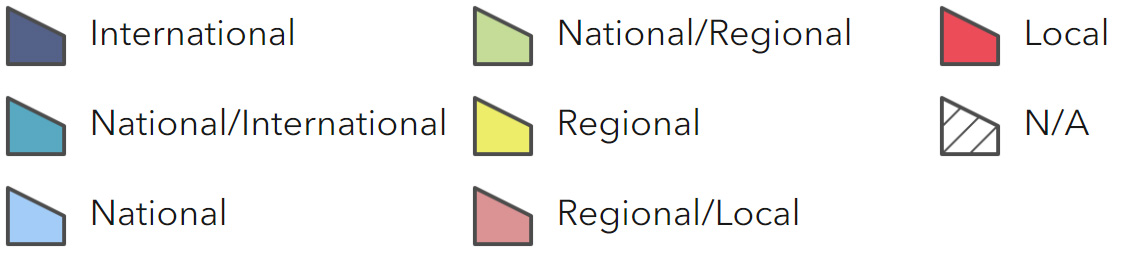
Main Beneficiaries Map
View Main Beneficiaries Map full screen in a new tab View Interactive Map HelpEcosystem service analysis
The following sections show the analysis used to determine key Ecosystem Service opportunities within the area. These opportunities have been combined with the analysis of landscape opportunities to create Statements of Environmental Opportunity. Please note that the following analysis is based upon available data and current understanding of ecosystem services. It does not represent a comprehensive local assessment. Quality and quantity of data for each service is variable locally and many of the services listed are not yet fully researched or understood. Therefore analysis and opportunities may change upon publication of further evidence and better understanding of the inter-relationship between services at a local level.
Note that numbers and figures in the body of the text are based on the 2014 profiles, unless otherwise stated.
Provisioning Services
Food provision
Assets/attributes: main contributors to service –
- Dairy and meat products
- Cereal crops
State – The predominant land use is grassland, with over a third (35 percent) of all holdings classified as livestock farms. Another third (29 percent) are classified as ‘other’ and likely to be small holdings. Between 2000 and 2009 there was a notable drop (32 percent) in the number of dairy farms.
In 2009 there were 194 holdings of more than 100 ha which represented 49 percent of the total farmed area. Small holdings of less than 5 ha accounted for 222 units, but covered less than 1 percent of the total farmed area.
There is increasing interest in apple production for ciders and apple juices in the area.
Main beneficiary – Regional
Analysis – Food production from this mixed farming landscape is a key service in this area. The levels and type of food produced reflects the soil productivity, the favourable climatic conditions and availability of water. Changes in climate and weather patterns may challenge the traditional outputs from the area, but new opportunities may also arise. Maintaining soil structure and condition will also be necessary to maximise adaptability. Such activity must be in a sensitive manner to manage potential impacts on other assets including biodiversity and the historic environment.
Changes in land ownership and the loss of traditional skills will not only impact on food production but on the management and conservation of the area and the benefits it provides for visitors and residents.
With the increase in interest in local produce, apples, apple juice and cider are increasingly being produced. Furthermore, changing ownership of farms has caused a renewal of interest in restoring or replanting orchards on traditional sites with local varieties of fruit trees.
Opportunities – Work with the local farming community to consider how to safeguard food provision while enhancing a range of key ecosystem services.
Work with farmers and local communities to ensure that the necessary skills and knowledge are maintained, shared and enhanced to secure a future for farming.
Support and encourage initiatives that add value to local food products and foster a strong brand, securing a more viable farm business.
Support community-based schemes that provide affordable food for local communities.
Principal services offered by opportunities –
- Food provision
- Biodiversity
- Regulating soil erosion
- Regulating soil quality
- Regulating water quality
- Sense of place/inspiration
Timber provision
Assets/attributes: main contributors to service –
- Existing commercial plantation
- Accessible broadleaved woodland
State – Fourteen percent of the NCA is woodland (11,010 ha) of which 1,676 ha is ancient woodland; much is designated SSSI. Seventy percent of the woodland is broadleaved, notably on the steep, often inaccessible slopes. Just over 20 percent is coniferous woodland, predominantly under commercial operation. Some plantations have undergone wide-scale restructuring and now achieve multi-purpose objectives.
Main beneficiary – Regional
Analysis – Many of the woodlands within the NCA have little value as providers of high-quality timber because of poor management. This may be a consequence of restricted access (for example on steep slopes), cost, the timber market, public relations, or lack of information and knowledge.
Restoration of some of the plantations, particularly those planted on ancient woodland sites, has occurred and is a priority for other such sites.
Invasive species (notably rhododendron and laurel) are impacting on woodland productivity, by restricting natural regeneration or favouring regeneration of undesirable species. Pests and diseases are also affecting woodland productivity; Phytopthora pathogens have already led to the clear-felling of areas within the NCA.
Opportunities – Encourage initiatives that promote the use of local timber and wood products and encourage communication and greater understanding between wood producers (large and small), processors and users.
Work with the local forestry industry and timber processors to ensure that the necessary skills and knowledge are maintained, shared and enhanced to enable sustainable woodland management.
Encourage management practices that produce well-structured woodlands and high-quality timber and, where appropriate, achieve multipurpose objectives. Balance the need for timber production and replanting against the regeneration of semi-natural habitats.
Support community schemes that promote positive woodland management and the use of wood products.
Principal services offered by opportunities –
- Timber provision
- Regulating soil erosion
- Biodiversity
- Regulating water flow
- Sense of place/inspiration
- Tranquillity
- Recreation
Water availability
Assets/attributes: main contributors to service –
- Rivers
- Aquifer
State – Overall the Blackdowns NCA is considered to have further water available for abstraction.
The majority of the area is underlain by the Upper Greensand aquifer, with some smaller areas of limestone aquifer towards the east. The method of abstraction from this aquifer is normally from single boreholes or spring sources for public and private water supply.
Natural springs support the flow of the main rivers of the NCA and associated wetland habitats. The Axe and the Culm are maintained by groundwater, contributing to its base flow during dry weather.
The Luxhay reservoir in the north of the NCA provides compensation flows to the River Tone which also supplies water to the Bridgewater and Taunton Canal.
Main beneficiary – Local
Analysis – Abstraction in this NCA is predominantly for public water supply and agriculture (East Devon WFD Management Area Abstraction Licensing Strategy, Environment Agency, 2012).
Across the NCA many stream headwaters are impounded for shooting and fishing.
Growth largely outside the NCA may affect abstraction levels in the future, such as the growth of Taunton, immediately to the north.
Opportunities – Seek opportunities to maximise the availability of water by reducing the rate that water flows through the area by the reinstatement of natural, meandering drainage patterns and channels and reinstating functional flood meadows adjacent to main water courses.
Promote management at the catchment scale, encouraging good environmental management of semi- natural habitats to aid water retention, increase storage and improve connectivity.
Principal services offered by opportunities –
- Water availability
- Regulating water quality
- Regulating water flow
- Food provision
- Biodiversity
- Recreation
Genetic diversity
Assets/attributes: main contributors to service –
- Fish
- Orchards
State – The Axe is an internationally important habitat, noted for its populations of lamprey, bullhead, otter and salmon. Most rivers support breeding trout populations.
The NCA contains some traditional orchards along river valleys which are a priority habitat and support local varieties of fruit trees.
Main beneficiary – Local
Analysis – Estuaries provide carbon sequestration opportunities as well as opportunities for biodiversity.
Traditional orchards contribute to sense of place and history and can provide high-value end produce.
Opportunities – Work with the local fishing community to consider how to safeguard and sustainably manage the rivers and estuary.
Encourage the expansion of areas of traditional orchards, especially those growing traditional Devon and Somerset varieties of fruit, and ensure that the necessary skills and knowledge are maintained, shared and enhanced to manage these orchards.
Support and encourage initiatives that add value to local food products and foster a strong brand.
Principal services offered by opportunities –
- Genetic diversity
- Biodiversity
- Food production
- Regulating water flow
- Sense of place/inspiration
- Sense of history
Biomass energy
Assets/attributes: main contributors to service –
- Woodland
- Hedgerows
State – Fourteen percent of the NCA is under woodland cover (11,010 ha) of which 7,647 ha is broadleaved and 2,425 ha coniferous. Included within these figures are 1,676 ha of ancient woodland. Hedgerows are a key landscape feature across the NCA.
Main beneficiary – Local
Analysis – Many of the woodlands, particularly those with restricted access due to their location on the steep valley sides, are small scale and are not currently under productive management. However, across the NCA there is some potential for the provision of biomass from some of these woodlands for local use. Similarly there is potential of using by-products from commercial timber production for local use.
With appropriate management it would be possible to produce woodfuel from hedgerows within the NCA for local use.
There is potential for short rotation coppice and miscanthus within the NCA however the benefits of biomass energy production would need to be balanced against biodiversity, landscape character and provision of other ecosystem services (DEFRA).
Opportunities – Support and encourage local initiatives that promote the sustainable management of woodlands and hedgerows for woodfuel production.
Encourage join-up between landowners and local communities, including skills sharing and knowledge transfer.
Identify and consider opportunities for planting of SRC and miscanthus, appropriately sited within the existing pattern of woodland, hedgebanks and semi-natural habitats.
Principal services offered by opportunities –
- Biomass energy
- Biodiversity
- Climate regulation
Regulating Services
Climate regulation
Assets/attributes: main contributors to service –
- Soils
- Floodplain grazing meadows
- Estuarine habitats
- Low input crops/ grassland
- Woodland
State – Carbon storage in the soils of the Blackdowns NCA is low (0-10 percent) apart from small, dispersed pockets where soil carbon may reach 20-50 percent beneath heathland and woodland, predominately in the north of the NCA.
In addition, there will be higher levels of carbon locked up in the soils of the flood plain grazing meadows.
Estuarine mud, silt and fringe habitats, particularly reedbeds and marsh, have a high carbon content. The Axe Estuary within the NCA provides carbon storage opportunities.
Main beneficiary – Local
Analysis – Most of the soils in the Blackdowns NCA offer limited potential to improve climate regulation. Therefore woodland is expected to be the most significant contributor to climate regulation in this NCA.
Expansion of woodland on suitable sites could help increase carbon sequestration while also offering increases in biodiversity, regulating soil erosion and water availability.
Estuarine habitats, particularly mudflats, reedbeds and marsh, have a high carbon content secured in deposits. While expanding the areas of these habitats may be restricted by topographic and fluvial systems, they should be allowed to develop and expand naturally and remain undisturbed.
Reductions of inputs can also play a role and will in turn help improve water quality and aquatic biodiversity services.
Opportunities – Increase sequestration of carbon by increasing woodland area and encouraging sustainable management, restoration and expansion of woodland, heathland and associated mire habitats, and wetland habitats in the river valleys.
Encourage sustainable and extensive grazing regimes on permanent pasture, particularly areas of flood plain and coastal grazing marsh.
Reduce greenhouse gas emissions through reduced fertiliser inputs and anaerobic digestion of farm wastes.
Principal services offered by opportunities –
- Climate regulation
- Regulating soil erosion
- Regulating soil quality
- Water availability
- Biodiversity
Regulating coastal erosion and flooding
Assets/attributes: main contributors to service –
- Shingle ridges, spits and beaches
- Estuaries and estuarine habitats
- Maritime cliff and slopes, coastal saltmarsh, coastal vegetated shingle
State – There have been attempts to manage the challenges of beach loss and coastal erosion through beach stabilisation as part of a number of schemes to protect towns such as Sidmouth and Lyme Regis. The western parts of Lyme Bay consist of cliffs formed of resistant lithology that erode slowly. This western area is also sheltered from south-westerly waves meaning that the shoreline is controlled by waves from the south and east. In the eastern part of Lyme Bay there is little cliff protection and the cliff toe erodes easily, contributing to existing instability of ancient and modern landslides which are driven largely by groundwater. The cliffs are retreating here at a relatively rapid rate.
Main beneficiary – Regional
Analysis – In the Shoreline Management Plan a ‘with present management’ scenario is being considered, involving continued presence of hard defences at Lyme Regis, and a policy of ‘do nothing’ for less developed areas of the coast. Seaton and Sidmouth have a high risk of coastal flooding (in Seaton this is combined with fluvial flooding from the Axe Estuary) with the largest number of properties at risk. There are a range of flood defence schemes in place along this stretch of coast, mainly within settlements.
The route of the South West Coast Path follows the coastline, linking the many beaches along this stretch of coast. Coastal erosion can interfere with access to these features.
Opportunities – Provide space for natural coastal processes where identified by the Shoreline Management Plan and the Estuary Strategy, compensating for loss of habitats by creating new areas of coastal habitat.
Work with local communities and stakeholders to raise awareness of the issues surrounding coastal erosion and flooding and assist them in planning for the future.
Manage natural habitats backing the coast and estuaries, expanding and re-linking (including through managed realignment) to build resilience to future sea level rise.
Manage the nationally and internationally important seacliff and undercliff habitats within the NCA.
Ensure that coastal access opportunities remain while adapting to a dynamic coastline through the provision of roll back land and information and advice to users.
Principal services offered by opportunities –
- Regulating coastal erosion and flooding
- Geodiversity
- Biodiversity
- Sense of place/inspiration
- Sense of history
- Recreation
Regulating water quality
Assets/attributes: main contributors to service –
- Watercourse fencing
- Wooded valleys
- Permanent pasture or woodland on steep slopes
- Cross-field hedgerows in arable areas
State – For information regarding the current state of water quality within this NCA, refer to the Environment Agency (Draft river basin management plan maps).
Main beneficiary – Regional
Analysis – Water quality is particularly important in this NCA due to the relationship between the river catchments and the coastal designated sites.
Improvement of water quality through buffering watercourses, reducing pollution pathways and run-off of both soil and nutrients could have significant impacts on regulating soil erosion, and enhancing biodiversity and soil quality. Additionally these changes could lead to improvements in the water quality status of bathing waters with a positive impact on recreational use of the waters.
The spread of non-native invasive species, especially Himalayan balsam, can lead to greater erosion of river banks and is detrimental to biodiversity.
Opportunities – Increase the amount of farmland managed under principles established under Defra’s Catchment Sensitive Farming initiative.
Restore, extend and create reedbeds and wetland habitats to act as silt traps.
Fencing watercourse and introducing cross-field hedgerows and tree planting, where appropriate, will reduce sedimentation and nutrient loading.
Eradicate non-native invasive species along river corridors.
(See also measures under regulating soil erosion)
Principal services offered by opportunities –
- Regulating water quality
- Regulating soil erosion
- Regulating soil quality
- Biodiversity
- Recreation
Regulating water flow
Assets/attributes: main contributors to service –
- Extensive grazing
- Hedgebanks and hedgerows
- Grazing marsh
State – While most of the area is at little or no risk from flooding because of the hilly topography, there are areas of high flood risk along the rivers Yarty, Otter and Axe. The Axe estuary is influenced by fluvial and tidal flooding; Seaton suffers from flooding from the Axe.
The mudstones, sandstones and pebble beds lying beneath the Otter catchment lead to significant surface run-off. The river responds rapidly to rainfall, and floods are characterised by a very rapid rise and fall in water levels, with high flood peaks.
Beneath the Axe catchment there are calcareous clays and mudstones, and Cretaceous Greensand and Chalk. Because of this mixed geology the river responds more slowly to rainfall than the other East Devon rivers. The flood peaks of the River Axe reduce as they reach the wide flood plain in its lower reaches but here floodwaters are often slow to recede.
Main beneficiary – Regional
Analysis – Flood risk is expected to increase with climate change and changes in land use. Management plans for flood risk reduction seek to: increase flood plain storage and create wetlands; ensure that development does not increase run-off; reconnect estuaries with flood plains, creating habitat and wildlife corridors and therefore enhancing biodiversity; maintain riverbanks; and promote better land management practices. The upper catchments of the rivers have been recognised as the most effective location for changes in land use and land management to reduce peak flows downstream.
Opportunities – Follow the principles described in the Catchment Flood Management Plans for the area: increase flood plain storage and create wetlands; ensure that development (particularly at Chard) does not increase run-off; and reconnect estuaries with flood plains, creating habitat and wildlife corridors.
Support land management practices that reduce flood risk by reducing soil compaction.
Expand areas of semi- natural woodland on steep slopes and extend the network of hedgerows to reduce overland flows.
Principal services offered by opportunities –
- Regulating water flow
- Biodiversity
- Water availability
- Regulating soil erosion
Regulating soil quality
Assets/attributes: main contributors to service –
- Underlying geology
- Soils
- Hedgerows and hedgebanks
- Woodland
- Semi-natural habitats
- Permanent pasture
State – The majority of the soils within the NCA are relatively poor. Over 96 percent of the area is classed as Grade 3 or poorer agricultural land. Soils on the high ground are generally poor and acidic while the valleys have more fertile brown earth and brown clay soils. The flat chalk plateau is more arable.
Organic matter may be being lost through frequent tillage. Lack of organic matter makes soils more susceptible to compaction and erosion.
Main beneficiary – Local
Analysis – Improving soil quality through increasing soil organic matter will have potential benefits for regulating soil erosion. It may also help with climate change regulation, though the capacity of these soils to make a significant contribution is limited.
Opportunities – Support management of soils that encourages the build-up of organic matter, for example through extensive grazing.
Support initiatives that promote awareness and understanding of soil structure and management.
Consider the consequences of mechanised activity and soil compaction, particularly in wet weather.
Promote good management of weak top soils; minimum tillage can help to maintain good soil structure.
Where organic matter is low, carefully increase organic matter inputs to improve soil structure.
Principal services offered by opportunities –
- Regulating soil quality
- Regulating soil erosion
- Regulating water quality
- Regulating water flow
Regulating soil erosion
Assets/attributes: main contributors to service –
- Cross-field hedgerows
- Buffer strips
- Uncultivated areas
- Woodland
- Semi-natural habitats
State – The Blackdowns NCA falls within two Defra priority catchments: the River Exe catchment (which includes the River Culm) and the rivers Axe and Otter catchment (which includes the Upper Axe and Yarty). The rivers Axe, Otter and Yarty are recorded as having high levels of sediments, partly as a result of soil erosion on the steeper slopes of these light sandy soils, especially where under cultivation. The open soils created by arable growing are particularly susceptible to soil erosion.
Main beneficiary – Local
Analysis – Efforts to increase vegetation cover on cultivated or bare soils on steep slopes, for example by reverting to grassland or semi-natural habitats, will help to increase the regulation of soil erosion.
Hedgerows can also help to impede overland flows and subsequent erosion, while having a positive impact on landscape character. In addition, taking measures to avoid bare soil conditions and exposed soils on steep slopes will also be beneficial. This can be achieved through avoiding clear-felling of woodland in sensitive areas.
Opportunities – Strengthen hedgebanks and hedgerows, and create grass buffer strips running at right angles to the slope across steeper slopes under arable cultivation to prevent soil erosion, especially in the Axe and Otter priority catchments. Strengthen the hedgerow network and increase the population of hedgerow trees across the flood plains of the Axe to filter out soils in suspension in times of flood.
Avoid clear-felling areas of woodland on steep slopes, and encourage new woodland planting to impede overland flows.
Encourage change from cultivation on steep slopes to permanent grassland and semi-natural habitats with extensive grazing and low fertiliser inputs.
Provide wide grass buffer strips and reedbeds adjacent to river banks to act as silt traps, and prevent livestock access to the water’s edge.
Plant areas of wet woodland and expand and link existing valley woodlands to further minimise soil erosion.
Support initiatives that promote awareness and understanding of soil structure and management.
Raise public awareness of the consequences of erosion caused by recreational pressure and encourage sustainable use of publicly accessible areas.
Principal services offered by opportunities –
- Regulating soil erosion
- Regulating water quality
- Water availability
- Regulating soil-quality
- Sense of place/inspiration
- Biodiversity
- Recreation
- Food provision
Pollination
Assets/attributes: main contributors to service –
- Heathland
- Hedgerows and hedgebanks
- Orchards
- Species-rich meadows
State – Areas of semi-natural habitat across the NCA, including species-rich grassland and heath provide sources of nectar for pollinating insects.
Dense networks of species- rich hedgerows also provide a source of nectar.
Traditional orchards are still found within the NCA, often adjacent to settlements or farmsteads.
Main beneficiary – Local
Analysis – The species-rich hedgerows and meadows and other areas of semi- natural habitat provide important sources of nectar for pollinating insects, although the contribution of pollination services to food production in this NCA is currently limited.
Over the last 20 years there has been a renewed interest in traditional orchards, with both new orchards being planted and old orchards being restored. Several community orchards have been established.
Opportunities – Increase the areas of semi-natural habitat, especially lowland heathland, coastal saltmarsh, fen and woodland with a diverse ground flora, as well as species-rich hedgerows and hedgebanks, to increase the diversity of flowering plants, and increase the area and diversity of habitat mosaics.
Support and promote sustainable management and planting of traditional orchards, including the use of local varieties. Encourage and support initiatives that provide new markets for apples.
Principal services offered by opportunities –
- Pollination
- Biodiversity
- Sense of place/inspiration
- Food provision
Pest regulation
No information available.
Cultural Services
Sense of place/inspiration
Assets/attributes: main contributors to service –
- Long Greensand Ridges
- Exhilarating views
- Dramatic coastline
- Enclosed pastoral valley landscape
- Densely wooded slopes
- Tranquillity
- Streams and springs with associated habitats
State – A nationally important landscape; 78 percent designated as Areas of Outstanding Natural Beauty.
A landscape of dramatic ridges offering a sense of exposure and opportunities for far-reaching views, incised by steep- sided, enclosed and tranquil valleys of a small scale. A heavily-wooded appearance created by long sinuous woodland along the scarp slopes, including ancient and semi-natural woodland, and an extensive network of hedgerows and hedgerow trees.
The ridge top plateaux are of a uniform and open nature, characterised by regular Parliamentary enclosure of medium- to large-sized fields with low hedgerows and long, straight roads. There is a dominance of beech, including beech avenues and remnant commons of lowland heath and scrub.
Numerous streams rise from the ridges and flow through the valleys, giving rise to wet pasture and carr woodlands as well as springline mires and rush pasture. The medieval irregular field pattern is delineated by dense, species-rich hedgerows, with a change in notable species to oak and ash. The winding and narrow road network sits deep within the hedgebanks.
At the coast the area’s diverse geology is dramatically evident through the tall cliffs, landslips, and sand and shingle beaches. The vibrant red sandstone starkly contrasts with the adjoining white Chalk. The significance of the coast is recognised by the entire length of the NCA being inscribed as a natural World Heritage Site. The exposed cliff top plateaux offer exhilarating views for miles along the coast and, from high peaks, extensive views inland. Steep-sided pastoral combes dissect the plateaux and, by contrast, provide sheltered and tranquil areas. The Axe Estuary contributes to the area’s sense of place and creates a zone of maritime influence inland.
The landscape of this NCA has inspired writers including John Fowles.
Main beneficiary – National
Analysis – The significance and scale of ‘sense of place’ for this NCA is reflected by 78 percent of the area being designated as Areas of Outstanding Natural Beauty. Most residents and visitors value and appreciate the attributes that combine to create the area’s sense of place; and there is a need for appropriate management to ensure that it is sustained for future generations.
Changes to landscape character through development or agriculture, and consequently potential impacts on the Blackdowns’ strong sense of place, need to be monitored, planned and managed.
Traditional land management practices and the associated skills and knowledge to enable these practices are essential to ensure the maintenance and enhancement of the distinctive landscape character.
Opportunities – Promote the use of landscape character guidance and other landscape tools to ensure that the key characteristics are protected and reinforced through land management and development.
Promote and manage sustainable recreation to ensure that experiential qualities are maintained.
Maintain and enhance tranquillity and dark skies, and their appreciation, minimising the impact of lighting and noise.
Work with land managers and local communities to ensure that the necessary skills and knowledge for the management of key landscape features, such as coppicing and hedge-laying, are maintained, shared and enhanced.
Principal services offered by opportunities –
- Sense of place/inspiration
- Sense of history
- Recreation
- Tranquillity
- Biodiversity
Sense of history
Assets/attributes: main contributors to service –
- Historic settlements and buildings
- Vernacular architecture
- A wealth of heritage assets
- Long-established farming culture and tradition
State – A sense of history is associated with a wealth of archaeological remains, including iron-age hill forts such as Membury and Castle Neroche, bronze- age barrows predominately between Gittisham Hill and Blackdown, and Second World War defences ranging from pillboxes, anti-tank cubes, rail- and road-block plinths and machine gun emplacements to military airfield landscapes at Upottery, Culmhead and Dunkeswell.
The historic character of the landscape is further reinforced by a sharply defined settlement pattern: sparse settlement on higher ground with farm buildings following straight enclosure roads contrasts with several settlements, many medieval in origin, lying along the springlines at the foot of escarpments or at river-crossing points. Buildings are constructed using a wide variety of traditional building materials including cob, sandstone, chalk, chert, flint, slate and thatch, with older colour- washed buildings along the coastline. Threshing barns, open-fronted linhays, ancient orchards, a number of manor houses including Cricket House and Rousdon, and masonry bridges are all characteristic features of the landscape.
Main beneficiary – National
Analysis – Archaeological remains are at risk of decay and damage because of a lack of knowledge and awareness. Some medieval buildings are at risk due to inappropriate maintenance techniques and lack of traditional skills, understanding, and knowledge.
A decline in farming families has resulted in a change of use of some traditional farm buildings and farmsteads, impacting on the sense of history.
Recreational pressure damages some archaeological and historic assets. Erosion, through heavy recreational use, causes some damage while lack of knowledge and understanding causes unintentional ‘vandalism’.
A change in farming practices has resulted in an increase in large sheds being built, sometimes out of scale with adjoining historic farmsteads.
Overhead cables and a proliferation of road signs can impact on the sense of history in towns and villages.
Opportunities – Support opportunities to enhance understanding of the historic environment resource through research and conservation.
Promote and support initiatives that provide educational and awareness opportunities for visitors and local communities.
Encourage and support initiatives that develop and enhance the traditional skills and understanding required to maintain and manage historic features.
Promote and support the significance of historic landscape character in development management.
Support audits of roadside signage and encourage a ‘decluttering’ where possible.
Support opportunities to put cables underground where there is not likely to damage the historic environment.
Principal services offered by opportunities –
- Sense of history
- Sense of place/inspiration
- Recreation
- Biodiversity
- Climate regulation
- Regulating soil erosion
Tranquility
Assets/attributes: main contributors to service –
- Wooded scarps and slopes
- Small-scale pastoral landscape
- Sunken, narrow, winding country lanes enclosed by hedgerows
- Dramatic coastline and coastal combes
- Rivers and estuary
State – The NCA has experienced a significant decline in tranquillity since the 1960s. Undisturbed areas have decreased from 97 percent in the 1960s to 61 percent in 2007 (CPRE Intrusion Map, 2007). Areas of low tranquillity are around the main towns (Honiton, Sidmouth, Seaton, Lyme Regis, Axminster and Chard) and along the main roads (A303, A30, A35 and A3052) and railway line.
Main beneficiary – Regional
Analysis – Much of the area remains undeveloped, uncluttered and free from recent development, particularly away from the coast and A35 corridor.
Seasonally, the coast can become a little less tranquil due to the many tourists and visitors to the area.
Opportunities – Maintain the current settlement pattern and seek to minimise the impacts of light and noise pollution.
Soften the edges of urban areas to incorporate development into the landscape setting and provide a network of green spaces and routes.
Support sustainable transport options to visitor destinations.
Support opportunities to put cables underground where this will not damage the historic environment.
Promote awareness of dark night skies and encourage and support initiatives that reduce light pollution.
Principal services offered by opportunities –
- Tranquillity
- Recreation
- Sense of history
- Sense of place/inspiration
Recreation
Assets/attributes: main contributors to service –
- Coast and estuaries
- South West Coast Path
- Regional routes
- Cycle trails
- Public rights of way
- Open access land/commons
State – The NCA offers an extensive network of rights of way totalling 1,100 km at a density of nearly 1.4 km per km2, as well as open access land covering 850 ha or just over 1 percent of the NCA. In addition, 34 km of the South West Coast Path National Trail, together with the National Cycle Network, East Devon Way, Blackdown Hills Valleyheads Way, the circular Herepaths and other local routes, provide a wealth of recreational opportunities.
Main beneficiary – National
Analysis – The coastal strip of this NCA has been popular with tourists and visitors since the Victorian times, both land-based visitors attracted by the beaches, surrounding countryside and often milder climate, and water-based users.
The public rights of way network inland of the coast is often considered fragmented with limited off-road routes for horse riders and cyclists; however, there have been some successes in developing promoted circular routes. The local road network provides other opportunities but the twisting, narrow lanes raise safety concerns for walkers, cyclists and horse riders.
The National Cycle Network Southern Coastal route (NCN Route 2, promoted as part of the Tour de Manche through the Cycle West Interreg project) and the Stop Line Way (NCN 33) running north from Seaton, are currently being developed. The latter offers potential as a green tourism trail linked with the developing the Axe Wetland and Natural Seaton initiatives.
Opportunities – Maintain and improve the quality of recreational assets, including the South West Coast Path National Trail, and other recreational routes, by supporting opportunities to connect and link with new multi-user routes, urban green spaces extending from built-up areas, and sustainable transport schemes, particularly in areas close to where people live.
Support proposals in the Devon, Somerset and Dorset Rights of Way Improvement Plans and in the various Green Infrastructure Delivery Plans.
Water-based recreation can provide close access to natural assets, both biodiversity and geodiversity, reducing the need for land-based infrastructure and vehicle movements. Balancing the increasing demand for water- based leisure with any potential resulting disturbance should be given careful consideration.
Principal services offered by opportunities –
- Recreation
- Sense of place/inspiration
- Biodiversity
- Geodiversity
Biodiversity
Assets/attributes: main contributors to service –
- Special Areas of Conservation
- Sites of Special Scientific Interest
- National Nature Reserves
- Semi-natural habitats
- Local wildlife sites
State – The NCA supports a range of priority habitats including 6,030 ha of woodland, 882 ha of coastal and flood plain grazing marsh, lowland meadows (658 ha) and maritime cliff and slope (606 ha).
1,533 ha (2 percent) of the NCA is designated as SSSI.
At present 36 percent of the designated resource is in favourable condition and a further 46 percent is in unfavourable but recovering condition.
Main beneficiary – National
Analysis – Improvement in the condition of designated sites, principally SSSI, is likely to have a positive impact on biodiversity over all, as well as other services.
Improvement in the condition of coastal habitats will also assist in the storage of carbon.
Connectivity of habitats and the current mosaic of habitats are essential to supporting and maintaining populations of the more mobile species found in the area (mammals, birds and many invertebrates). Less mobile species (many plants, lichens and mosses, and some invertebrates) will benefit from new and permanent opportunities to extend their current range, particularly in the face of climate change.
Opportunities – Maintain and where necessary improve the condition of all designated sites and priority habitats.
Encourage and support the maintenance and expansion of semi-natural woodland, particularly through natural regeneration along river valleys.
Promote management at a landscape scale, encouraging the extension and linking of habitats, the creation of new habitats and increased species diversity.
Support the restoration and improvement of plantations on ancient woodland sites for the benefit of biodiversity and a range of ecosystem services.
Work with land managers and local communities to ensure that the necessary skills and knowledge are maintained, shared and enhanced to secure a future for traditional farming and forestry and the habitats associated with them.
Promote and increase knowledge and understanding of the NCA’s biodiversity amongst those who influence, or are engaged in, the management of the landscape.
Principal services offered by opportunities –
- Biodiversity
- Sense of place/inspiration
- Climate regulation
- Pollination
Geodiversity
Assets/attributes: main contributors to service –
- Jurassic Coast World Heritage Site
- Geological and geomorphology interest SSSI
- Local Geological Sites
- Cliffs and geological exposures
- Coastal geomorphology
- Triassic red sandstones and mudstone
- Upper Cretaceous Chalk
- Lower Cretaceous Upper Greensand and Gault Clay
State – The importance of the NCA’s geodiversity is recognised internationally by inclusion of the entire coastline as part of the Dorset and East Devon Coast World Heritage Site (Jurassic Coast).
The significance of the site is derived from the exceptional rock record, fossil record and geomorphological processes. Each of these elements is exemplified within the NCA boundaries including the fossil rich sites around Sidmouth and Lyme Regis, stratigraphy that includes the Triassic-Jurassic boundary and geomorphology that includes some of the largest and most-studied coastal landslide complexes in Europe.
Historically these features have been the source of significant developments in the Earth Sciences since the early 1800s, including the first scientific recording of a landslide and the earliest artistic re-creation of a prehistoric environment (Durior Antiquior).
The coast is also designated a Special Area of Conservation and SSSI, for features including geodiversity.
There are 7 geological SSSI across the NCA and a further 5 mixed interest SSSI.
Beer Quarry and Caves is also designated a Special Area of Conservation and SSSI.
The alternating periods of marine incursion and mountain building can be observed both in the topography of the area and the coastal and inland exposures (cliffs, quarries and road cuttings).
More recent coastal geomorphological features, including sand and shingle spits and beaches, are present.
Main beneficiary – International
Analysis – Geodiversity sites and features occur across the area with concentrations and particular features of interest along the coast, including hard rock features and coastal processes.
The underlying geology, particularly the red Permo- Triassic sandstones, Greensand and flint gravels have influenced the biodiversity, agriculture, industry, building materials, culture and traditions across the area.
The geology and geomorphology across this area allows for the study and interpretation of earth sciences up to the earliest occupation of the landscape by man.
Opportunities – Identify and realise opportunities for enhanced access to, and recognition and understanding of, the internationally important geodiversity of the area.
Maintain natural geomorphological processes, particularly along rivers, estuaries and at the coast, that contribute to the regulation of coastal erosion and flooding.
Maintain vernacular buildings using local stone wherever possible and support the use of local stone in new development to reinforce links with the underlying geology.
Principal services offered by opportunities –
- Geodiversity
- Regulating coastal erosion and flooding
- Food provision
- Biodiversity
- Regulating soil quality
- Sense of place/inspiration
- Sense of history