

National Character Area 90
Bedfordshire Greensand Ridge - Analysis: Ecosystem Services
Analysis supporting Statements of Environmental Opportunity
The following analysis section focuses on a selection of the key provisioning, regulating and cultural ecosystem goods and services for this NCA. These are underpinned by supporting services such as photosynthesis, nutrient cycling, soil formation and evapo-transpiration. Supporting services perform an essential role in ensuring the availability of all ecosystem services.
Bodiversity and geodiversity are crucial in supporting the full range of ecosystem services provided by this landscape. Wildlife and geologically-rich landscapes are also of cultural value and are included in this section of the analysis. This analysis shows the projected impact of Statements of Environmental Opportunity on the value of nominated ecosystem services within this landscape.
Further analysis on landscape attributes and opportunities for this NCA is contained in the Analysis: Landscape Attributes & Opportunities section.
Natural Capital
Further information on Natural Capital within this NCA is contained in the Natural Capital and Key Ecosystem Services section.
The Bedfordshire Greensand Ridge NCA provides a wide range of benefits to society. Each is derived from the attributes and processes (both natural and cultural features) within the area. These benefits are realised through the ‘ecosystem services’ that flow from the ‘ecosystem assets’ or ‘natural capital’ of a place.
Natural capital means ‘the elements of nature that directly or indirectly produce value to people, including ecosystems, species, freshwater, land, minerals, the air and oceans, as well as natural processes and functions’ (Natural Capital Committee, 2017).
Ecosystem Services Main Beneficiaries
The below map displays the main beneficiaries of each ecosystem service identified within this NCA and neighbouring NCAs. These range from being of international importance to local importance. Some services have not been assessed within all NCAs, and therefore in some NCAs are displayed as “N/A” (not applicable).
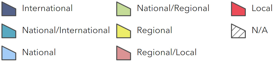
Main Beneficiaries Map
View Main Beneficiaries Map full screen in a new tab View Interactive Map HelpEcosystem service analysis
The following sections show the analysis used to determine key Ecosystem Service opportunities within the area. These opportunities have been combined with the analysis of landscape opportunities to create Statements of Environmental Opportunity. Please note that the following analysis is based upon available data and current understanding of ecosystem services. It does not represent a comprehensive local assessment. Quality and quantity of data for each service is variable locally and many of the services listed are not yet fully researched or understood. Therefore analysis and opportunities may change upon publication of further evidence and better understanding of the inter-relationship between services at a local level.
Note that numbers and figures in the body of the text are based on the 2014 profiles, unless otherwise stated.
Provisioning Services
Food provision
Assets/attributes: main contributors to service
Soils
Mixed pastoral and arable farming
Woburn Deer Park
State – The Ridge supports a mixed pastoral/ arable (mostly cereals with some vegetable crops) farmed landscape.
46 per cent of the agricultural land was classified as Grade 3 under the Provisional ALC Survey, and a further 20 per cent as Grade 2.
Venison from Woburn Deer Park is a local delicacy but is not marketed widely.
Main beneficiary – Regional
Analysis – The Ridge supports mixed pastoral and arable agriculture but the statistics indicate a decrease in farmed area, cropping and livestock numbers since 2000.
Within the historic parklands the farmed landscape is perhaps less likely to be influenced by changes in the market than is the case for other NCAs.
Population increase is likely to drive the pressure for increased yields locally and this will place further demands on ecosystem services such as regulation of soil erosion, soil quality and water quality
Opportunities – Promote best practice principles, through agri-environment schemes, including the establishment of wide buffer strips and tall hedgerows, to help address soil erosion, soil quality, water quality and water availability issues.
Secure opportunities to encourage sustainable farming to enhance biodiversity by, for instance, reducing herbicide/ pesticide use, providing uncultivated strips around field margins and retaining winter stubble.
Promote the sale of locally sourced high-quality venison from Woburn Deer Park.
Principal services offered by opportunities –
- Food provision
- Biodiversity
- Regulating soil erosion
- Regulating soil quality
- Water availability
- Pollination
- Sense of place / inspiration
- Sense of history
Timber provision
Assets/attributes: main contributors to service
Areas of conifer plantation woodland
Wet woodland and mire at Flitwick Moor
State – There is a high proportion of coniferous and deciduous woods, heath and pasture on the scarp slope and woodlands plus medium-scale arable farming on the dip slope.
There are areas of Forestry Commission land within the NCA with, for instance, Maulden Wood and Rowney Warren being the largest at 182 and 114 ha respectively.
Main beneficiary – Regional
Analysis – There is scope to increase timber production but this would have to be balanced against other ecosystem services including biodiversity and food production.
One third of the woodland is ancient semi-natural woodland and not suitable / available for timber provision.A Working Woodland Centre has been established to promote woodland business and education.
The creation of the Forest of Marston Vale across part of the NCA will yield increased woodland cover (up to 500 ha or more) and future timber supply.
Opportunities – Promote sustainable forestry with replanting to replace harvested trees.
Promote awareness of woodland and its associated industries
and purposes via the Working Woodland Centre.
Support the work of The Marston Vale Trust in creating the Forest of Marston Vale.
Principal services offered by opportunities –
- Timber provision
- Biodiversity
- Recreation
- Climate regulation
- Regulating water flow
- Sense of place / inspiration
Water availability
Assets/attributes: main contributors to service
Aquifer
Rivers Flit, Ivel and Ouzel
State – Due to the porous nature of the underlying geology, the Ridge is an aquifer and
groundwater abstraction is a significant local resource.
The main watercourses are the River, Flit, Ouzel and Ivel.
The whole of the NCA is classed as a Nitrate Vulnerable Zone (NVZ).
Main beneficiary – Groundwater availability is good across the NCA.
The Woburn Sands Aquifer is extracted both with the NCA and for at least 13 km beyond its boundaries; many of these abstractions are for agricultural or industrial uses rather than for potable water.
Anglian Water has several large public water supply abstractions from the aquifer.
Increased storminess and drought resulting from climate change are likely to increase and measures needed to be taken in preparation for this.
Flood plain grazing marsh and wet woodland habitats are particularly sensitive to water availability.
Analysis – Regional
Opportunities – Promote the sustainable use of local water resources by both commercial and domestic users.
Work to maintain and improve, as appropriate water quality in local watercourses.
Encourage water efficiency measures in the design of any new development.
Work with the Environment Agency and the water industry to ensure that abstraction does not damage or cause loss of semi-natural habitats.
Address the issues of over abstraction which can have an impact on river flows affecting the ecology during low flow periods
Principal services offered by opportunities –
- Water availability
- Regulating water quality
- Regulating water flow
- Climate regulation
- Biodiversity
- Sense of place / inspiration
Genetic diversity
No information available.
Biomass energy
Assets/attributes: main contributors to service
Existing woodland and new plantations
State – There is significant biomass provision for wood chip and similar products from the Bedford Estate (Woburn) and elsewhere with local markets.
Main beneficiary – Regional
Analysis – It would be possible to increase biomass provision from this NCA by appropriate traditional coppice management of existing woodland and as a by-product of the Ridge’s timber production.
Miscanthus could be grown in pockets on the dip slope but could have a detrimental impact on land use and agriculture.
Opportunities – Secure opportunities to increase further and small-scale biomass production on the dip slope including wood chips as a result of active woodland management.
Principal services offered by opportunities –
- Biomass energy
- Biodiversity
Regulating Services
Climate regulation
Assets/attributes: main contributors to service
Woodland including wet woodland
Semi-natural grassland
Heathland
Unimproved pasture
Soils
State – The wooded nature of the NCA heightens the role that it plays in the sequestration and storage of carbon, especially where the woodland is under management.
The soils also have a role in carbon storage, especially the areas of peat in the Flit valley, as do the limestone strata where these exist.
Main beneficiary – Local
Analysis – The Ridge is well-wooded with areas of deciduous trees as well as coniferous plantations. In addition to the commercial forestry there are many mature trees in the NCA’s parklands.
There is potential for further woodland planting which would increase the carbon storage potential further as long as this results in a net increase of the woodland cover.
The enhancement of semi-natural habitats such as grassland and heathland would improve the NCA’s ability to sequester and store carbon.
Carbon is locked up in peat and, to a lesser extent, in other habitats including woodland, grasslands and heathland and continued careful management, and even expansion where appropriate, would enhance the ability to sequester and store carbon.
Where the Ridge is underlain by limestone, for example, the Shenley Limestone Formation, carbon was locked up in its formation.
Opportunities – Increase the area under woodland for commercial, conservation and recreational purposes as well as to mitigate climate change.
There are opportunities to extend and improve the condition of semi-natural habitats to increase their carbon absorption capacity.
There are opportunities to encourage sustainable farming to support soil carbon storage capacity by, for example, ploughing less frequently and adding organic matter as appropriate.
There are opportunities to protect the peats in the Flit valley.
Explore opportunities to promote biomass fuel from forestry operations.
There are opportunities to increase soil organic matter helping carbon retention as well as the drought-tolerance of crops in the short term.
Principal services offered by opportunities –
- Climate regulation
- Biomass provision
- Biodiversity
- Sense of place / inspiration
- Sense of history
Regulating coastal erosion and flooding
No information available.
Regulating water quality
Assets/attributes: main contributors to service
Aquifer and rivers
Soils
Woodland including wet woodland and mire
Semi-natural grassland
Hedgerows
State – For information regarding the current state of water quality within this NCA, refer to the Environment Agency (Draft river basin management plan maps).
Main beneficiary – Regional
Analysis – The underlying geology, woodland, grassland and similarly-functioning semi- natural habitats have the potential to filter out pollutants This ability could be greatly strengthened by linking or expanding existing fragments of these habitats.
Waterbodies in the rivers Ouzel, Flit and Ivel catchments are under investigation by the Environment Agency to establish reasons for failure to achieve good ecological status and to identify actions that should be taken to improve the situation. This work is required by the EU Water Framework Directive. Reasons for failure can be one of a combination of pressures, for example, lack of flow, the impact of point sources such as treated sewage effluent discharges, diffuse pollution from agricultural and urban land, poor river bed and bank condition and the impact from non-native invasive species such as signal crayfish and Himalayan balsam.
Many wetland habitats are sensitive to poor water quality.
There are problems with sewage effluent at Flitwick
Catchment-sensitive farming helps reduce the inputs of phosphates and nitrates to watercourses.
Opportunities – Work with public bodies, farmers and non-government organisations to reduce surface and groundwater pollution at a catchment scale by using fertilisers strategic
Manage farmland under the principles established under the England Catchment Sensitive Farming Delivery Initiative.
Encourage landowners and managers to manage land to prevent the drying out of peat. Encourage the establishment of increased areas of semi-natural habitat such as flood plain grazing marsh and reedbed which slow the passage of water through the hydrological system.
Encourage the reversion from arable to species-rich acid grassland where appropriate close to sensitive semi- natural habitats.
There are opportunities to work with farmers to reduce surface and groundwater pollution at a catchment scale by using fertilisers more strategically and maintaining good quality water in the aquifer.
Expanded areas of woodland and grassland could also act as filters and would also help to improve biodiversity.
Seek opportunities to manage and treat effluent.
Principal services offered by opportunities –
- Regulating water quality
- Biodiversity
- Regulating soil quality
- Regulating soil erosion
- Sense of place / inspiration
- Pollination
Regulating water flow
Assets/attributes: main contributors to service
Bedrock/aquifer
Rivers
Woodland including wet woodland and mire
Hedgerows
Soils
State – The bedrock and its aquifer absorb much meteoric water and prevent flooding that would otherwise be caused by runoff. Some of this water flows out through the springs and thence into the rivers rather than being stored in the aquifer.
Much water also flows through the NCAs from higher up the rivers’ courses.
Main beneficiary – Local
Analysis – The expected changes in rainfall pattern due to climate change with more rainfall in winter and more intense rainfall in summer could exacerbate flooding events.
Good flow regulation within the NCA would be helpful in preventing erosion of the banks of watercourses.
The woodlands of the Ridge affect its hydrology as they take up large quantities of water and their roots act as a physical barrier.
There have been hard flood defences around Flitwick, where hard engineering has consequently taken place. There are still traditional flood meadows in the valley floors which form corridors of riparian habitat linking the Greensand Ridge and the Bedfordshire and Cambridgeshire Claylands NCAs.
There has been major work to link wetland habitats along the Flit valley, especially between Flitwick Moor and Flitton Moor.
Opportunities – Increase the current flood storage capacity by creating or increasing areas of flood plain grazing marsh reedbeds, concentrating on areas at risk.
Implement the recommendations from the EA Anglian Habitat Restoration Programme.
Produce a strategy to develop a sustainable, integrated and long term flood risk management approach.
Use hedgerows and buffer strips to protect semi-natural habitats.
Explore opportunities to work to reduce over abstractions and their effect on water flow.
Principal services offered by opportunities –
- Regulating water flow
- Regulating soil quality
- Regulating soil erosion
Regulating soil quality
Assets/attributes: main contributors to service
Soils
Woodland
Semi-natural habitats
Unimproved pasture
State – The Ridge has a mixture of soil types, with loams and sandy soils predominating. Areas of clays resist water infiltration and can be a source of diffuse pollution as a result of surface run-off.
Only 2 per cent of the NCA’s soils were classified as Grade 1 under the Provisional Agricultural Land Classification Survey and 20 per cent as Grade 2; 46 per cent was classified as Grade 3.
The remaining 32 per cent was of lower grade or non-agricultural (for example under woodland) or urban.
There is a mosaic of semi-natural habitats and unimproved pasture where soils are not (directly) subject to agricultural inputs.
Main beneficiary – Local
Analysis – Most of the non-arable land is of low quality and supports pastoral agriculture.
Areas under woodland or permanent vegetation result in stability in soil quality or increases in organic material and soil fauna.
In the main, continuing pastoral land use will maintain the current condition of soils. Localised compaction and erosion may occur in areas with high levels of visitor access; on or around marked routes and in areas of open access. Current levels of grazing are unlikely to cause negative impacts in soil quality.
Where land is in arable use, there are more risks to soil quality.
Opportunities – Encourage best practice grazing regimes to avoid localised areas of poaching and compaction.
Manage areas with high levels of visitors and recreational use that result in localised soil compaction to avoid further impacts on soil quality or relieve current negative impacts.
Any increase in the area under cropping should aim to use soil- friendly cultivation techniques.
There may be opportunities for local composting to provide increased soil carbon at selected spots.
Opportunities to work to keep the soil on the land by reducing erosion.
Encourage the adoption of the Defra Code for Good Agricultural Practice (2009) and Environment Agency’s Think Soils’ manual (2008) to avoid soil compaction and maintain good soil structure.
Principal services offered by opportunities –
- Regulating soil quality
- Regulating soil erosion
- Food provision
- Biodiversity
- Climate regulation
- Sense of history
- Sense of place / inspiration
Regulating soil erosion
Assets/attributes: main contributors to service
Soils with high organic matter
Semi-natural habitats
Extensively grazed permanent grassland
Trees and woodland
Hedgerows
State – The acidic, nutrient- poor, free draining soils are less fertile than the surrounding Claylands. This has influenced the vegetation and agricultural activities of the area, making it more suitable for the establishment of hunting estates comprised of heath and mixed woodland than for agriculture, reducing soil erosion.
Main beneficiary – Local
Analysis – Use of heavy high-powered equipment increases the risk of soil compaction and consequently incidence of enhanced run- off and erosion by water. For mineral soils, management to build up soil organics reduces the chance of soil compaction and therefore erosion.
Preventing soil erosion would greatly benefit food production but would also help semi- natural wetland habitats such as the fens in the areas which are sensitive to sediment run-off. Soil erosion, (by water or wind) from cultivated and unvegetated land has an important link with pollution to surface waters, particularly from pesticides and phosphates although the latter originate significantly more from sewage than from agriculture.
Erosion on the Ridge also occurs as a result of mountain biking, especially at Rowney Warren and Aspley Heath.
Opportunities – Encourage landowners and managers to use farming methods that protect the soil, such as maintaining vegetative cover or improving the soil structure with organic matter. Use of grass buffer strips in areas of arable land can reduce soil erosion from susceptible arable fields in the
autumn and winter.
Encourage the adoption by farmers and landowners of the Environment Agency’s ‘Think Soils’ manual (2008).
Seek opportunities to work to keep the soil on the land.
Consider laying tall hedgerows, where appropriate, to restrict the transport of sediment by wind and water and reinstate hedgerows where also appropriate and in keeping with the character of the landscape.
Principal services offered by opportunities –
- Regulating soil erosion
- Regulating soil quality
- Food provision
- Biodiversity
- Climate regulation
- Sense of history
- Sense of place
Pollination
Assets/attributes: main contributors to service
Heathland
Grassland
Gardens
Field margins
State – Lowland meadows, lowland heathland and flood plain grazing marsh jointly make up approximately 3 per cent of the NCA’s area.
Main beneficiary – Local
Analysis – Habitat for pollinating insects includes small areas of lowland meadows, lowland heathland, and flood plain grazing marsh. Increasing and securing pollinator numbers increases food security.
Opportunities – There are opportunities to restore areas of semi-natural habitats
Use the environmental stewardship scheme (for example pollen and nectar mixes for field margins) to enhance landscape character and increase landscape connectivity. This would increase the ability of the pollinators to service nominated food crops.
Principal services offered by opportunities –
- Pollination
- Food provision
- Biodiversity
- Sense of place / inspiration
Pest regulation
No information available.
Cultural Services
Sense of place/inspiration
Assets/attributes: main contributors to service
The Greensand Ridge, rising from the surrounding lowland
Wooded horizons and the wooded ridgeline
Distinctive Geodiversity
Long views over the surrounding rural landscape
Traditional building material, and ‘Arts and Crafts’ architecture
A high concentration of parkland and large houses
State – The Bedfordshire Greensand Ridge has a strong and distinct sense of place.The scarp and dip slopes have a distinct but only slightly different character. The orange colour of the exposed faces of quarries such as those at Sandy contrasts strongly with the colours of the surrounding Claylands.
The pattern of woodlands, especially around Sandy and heathland in the NCA, add to this. The woodlands are a distinct contrast to the Claylands around the Ridge.
The views across the surrounding Claylands and to the Chilterns also contribute to the sense of place as do the traditional building material, nucleated settlement pattern, ‘Arts and Crafts’ architecture and other vernacular building materials and styles , which are strongly evocative of the time they were built and is locally distinctive.
Older buildings constructed with local materials – sandstone, ironstone, brick, thatch and render add to this distinctiveness.
Main beneficiary – Regional
Analysis – The main pressures which could affect the sense of place and inspiration of the Greensand Ridge include development that could obscure the landform, imported and bland building materials such as corrugated metals for industrial units.
Development of inappropriate style could also damage the sense of community on the ridge.
Opportunities – There are opportunities to prevent inappropriate development and to maintain the parklands and estates.
There are opportunities to maintain the distinctive character of local buildings and villages.
Opportunities to promote distinctive local recreation such as the Greensand Ridge Walk.
Principal services offered by opportunities –
- Sense of place / inspiration
- Sense of history
- Recreation
- Tranquillity
Sense of history
Assets/attributes: main contributors to service
Historic settlements, farmsteads and buildings
Fine examples of Arts and Crafts vernacular
Country Houses and associated Parklands
‘Capability Brown’ plantings
Ridge and furrow
State – This NCA has many historic structures and contains more country houses than any other NCA area for area.
There is a wealth of historic farm buildings and churches.
Nationally important examples of ridge and furrow survive at Hockliffe and Potsgrove.
Main beneficiary – Regional
Analysis – The many heritage assets, including the country houses, Woburn Abbey and Deer Park and the many properties in “Arts and Crafts” style contribute to the sense of local history as much as they do to the sense of place. The great majority of farm buildings are unconverted and intact and historic churches are ‘stand-out’ features in the landscape.
The ridge and furrow at Hockliffe and Postsgrove, surviving under grassland, is of national importance.
The main pressures on the sense of history are, or would result from, inappropriate development either destroying or obscuring historic features.
Opportunities – Use agri-environment agreements where possible to protect historic farmsteads and buildings and features including ridge and furrow and other earthworks.
Promote and use local building materials – brick, thatch and render and, locally around Ampthill, ironstone, and use local styles when restoring existing structures or building new developments.
Put in place design and conservation plans to guide and inform new development to ensure it respects intrinsic character.
The landscapes designed and planted by Capability Brown are ideally placed for continuing conservation.
Seek opportunities to preserve the history and living history of the great houses and parklands.
Principal services offered by opportunities –
- Sense of history
- Tranquillity
- Sense of place / inspiration
Tranquility
Assets/attributes: main contributors to service
Areas of woodland and heathland
Historic parkland and country parks
Rivers, flood plains
Greenbelt
State – The more tranquil areas of the Ridge are found in the north-west of the NCA.
There are numerous areas of woodland and heathland along the Ridge as well as areas of historic parkland and country parks.
The southern boundary of the NCA is marked by the River Flit.
The greenbelt proportion of the NCA provides tranquillity in the areas it covers.
Main beneficiary – Local
Analysis – The growth in road and rail traffic since the 1960s, and the development of the settlements within the NCA, has contributed to the decrease in areas free from intrusion.
Intrusion by light and noise pollution has increased considerably since the 1960s when only Leighton Buzzard and major transport routes were intruded.
Woodland and heathland provide recreation away from the hustle and bustle of everyday life.
Opportunities – There are opportunities to work with local authorities and Railtrack to minimise noise and light pollution, for example by ‘screening’ major transport routes by hard landscaping or by the planting and/or screening hedgerows.
Seek opportunities to protect woodlands and to manage recreation sites in such a way that sound from them does not carry further afield.
Principal services offered by opportunities –
- Tranquillity
- Sense of place / inspiration
- Recreation
Recreation
Assets/attributes: main contributors to service
Country parks and Woburn Safari Park
Historic country houses and associated parkland
Right of way networks and footpaths including the Greensand Ridge Walk
Grand Union Canal
State – The Woburn estate and its associated Safari Park and Deer Park, and other historic houses, are major draws for tourists offering history and wildlife.
The rights of way and the Greensand Ridge Walk offer good opportunities for long-distance walking.
Boating is popular on the Grand Union Canal which cuts though the NCA and the towpath acts as another long-distance path.
The grounds of the RSPB’s headquarters at Sandy provide important tranquillity with high biodiversity.
Main beneficiary – Regional
Analysis – Increased public access through the creation of country parks, Forestry Commission woodland and the Greensand Ridge Way, which follows the length of the ridge, has widened the public perception of this relatively private landscape.
Pressures on the NCA’s recreational facilities include, especially in the case of Woburn Abbey and its parks, over-use and congestion, traffic noise and pollution.
While there is little pressure on the designed walking routes, there is much boating and recreational pressure on the Grand Union Canal.
While the grounds of the Lodge are tranquil, there is a danger of pressure on the loading leading to it from Sandy. There are numerous cycling routes – including circular ones – along the Ridge.
A Centre Parc holiday village is currently under construction; Rowney Warren Wood Forestry Commission/Southill Estate are popular for walking and cycling;
At Old Warden/Shuttleworth, there are an aircraft museum, Swiss gardens, and a birds of prey centre.
Opportunities – There are opportunities to increase the availability of ‘green’ transport to the country parks and stately homes.
There are opportunities to manage the parks while balancing their use with the protection of their historical quality and character
There are opportunities to maintain and extend rights of way along the Ridge both for local usage and tourists. Also to manage the use of bicycles and to minimise soil erosion resulting from their use.
There are also opportunities to increase sustainable recreation and tourism including walking along the Greensand Walk. Also to increase access to, and promotion of, ‘free’ resources such as views
Explore opportunities to provide sustainable transport options to increase access to woodland sites.
Seek opportunities to encourage users of the Grand Union Canal to leave their boats temporarily and explore the local area
Principal services offered by opportunities –
- Recreation
- Sense of place / inspiration
Biodiversity
Assets/attributes: main contributors to service
Semi-natural habitats
Ancient woodlands
Rivers and wetlands
Wildlife
Historic Parklands with veteran trees
Greenbelt
State – The Greensand Ridge has a wealth of semi-natural habitats.
There are a number of ancient woodlands within the NCA.
Priority habitats including lowland heathland and flood plain grazing marshes are scattered throughout the NCA.
Rivers and wetlands here support a wide range of species including, lower plants including liverworts, and fungi. The wetlands include former quarries restored under the Nature After Minerals scheme.
Adders have been reintroduced and supported at isolated locations along the Ridge.
A large part of the western end of the NCA is classified as greenbelt.
Main beneficiary –
Analysis – The priority habitats of the Ridge, resulting largely from the geology and hydrology, support a wide range of flora and fauna.
Ancient, semi-natural woodland is found on a mix of soil types ranging from heavy poorly drained clays to acid well drained soils associated with the Lower Greensand.
Lowland heathland usually found on outcrops of Greensand and typified by heather and wavy hair-grass supports a characteristic mix of species, which along the Ridge includes notables such as the natterjack toad, nightjar, adder and proliferous pink.
Open sandy areas provide excellent conditions for a range of specialised invertebrates, especially bees and wasps and spiders.
Lowland acid grassland is restricted to well-drained Greensand soils. The sward is characterised by fine-leaved grasses such as fescues and bents, with a range of plants such as tormentil, heath bedstraw, shepherd’s cress and clovers.
Bryophytes, rare/scarce macrofungi and lichens can be a special feature. Common blue and small copper butterflies can be abundant and there are records for bugs such as the bishops mitre shield bug. Some of the best remaining areas of acid grassland in the county are at places such as Ampthill Park and Woburn Park.
The acidic waters rising from the Greensand aquifers supports a mix of different wetland habitats including acid mire, flood plain grazing marsh and wet woodland. These have a rich assemblage of specialised wildlife, especially sedges, lower plants such as bog-mosses and liverworts, and invertebrates. The wet woodlands are characterised by alder, birch and willow, providing shady conditions for specialised fungi and liverwort species. The rare black poplar can also be found. There are also some areas of marsh and fen on more calcareous soils, with species like greater tussock sedge, and jointed rush.
Remaining areas of wood pasture and parkland are characteristic and significant in Bedfordshire. Many contain extensive areas of lowland grassland and are especially rich in mature and veteran trees.
Opportunities – Designated sites could be managed, protected and extended and fragmented habitats connected and expanded.
Buffer strips could be created around field margins.
There are opportunities to ensure that any development in the NCA is sustainable.
Awareness of local, important species can be raised and measures to protect them and increased their range/numbers put in place.
Continue to value and retain the Greenbelt.
Prevent the introduction and spread of non-native invasive species (plants and animals) that have an adverse impact on river life biodiversity and ecological status
Principal services offered by opportunities –
- Biodiversity
- Regulating Water Quality
- Regulating Water Flow
- Sense of place/ Inspiring Places
- Sense of Tranquillity
- Recreation
Geodiversity
Assets/attributes: main contributors to service
Striking landform that clearly reveals geological processes
Natural exposures
Geological and mixed interest SSSI and Local Geological Sites
Quarries – fuller’s earth and high- quality sands
Vernacular building stone
State – The geological importance of the Greensand Ridge is underlined by the SSSI designated for their geological interest and by 15 Local Geological Sites.
The bedrock geology dates from the Cretaceous Period but two of the Local Geological Sites also have Quaternary interest.
The Greensands include a thin layer, the famous Shenley Limestone, at their top; this is extraordinarily rich in fossil marine shell species, especially brachiopods.
High-quality sands from the Ridge are used for glassmaking and fuller’s earth, originally used to remove grease from sheep’s wool, is currently used in a variety of chemical processes.
Local stone is important here as a distinctive building material.
Main beneficiary – National
Analysis – The underlying Cretaceous geology of the Lower Greensand Group gives the Ridge its distinctive landform and has influenced the NCA’s social and economic history and provides the route for the Greensand Walk.
Exposures of rock, especially those designated as SSSI or Local Geological Sites, are important for the geology and geological processes they reveal. The fossil fauna of the Shenley Limestone is important for the biology it reveals.
Local stone is an important resource – vernacular buildings such as churches would be difficult to repair or renovate without bringing stone long distances.
Opportunities – There are opportunities to maintain views of and access to geological features and exposures where appropriate, improving access to cuttings, quarries and other exposures of geological features for increased understanding and enjoyment of geodiversity as well as for uncovering fossils and stratigraphy of major importance.
Seek opportunities to interpret the geology to enhance the Greensand Ridge Walk.
Maintain resources such as small-scale quarries for the repair and renovation of local vernacular buildings.
Principal services offered by opportunities –
- Geodiversity
- Sense of place/ inspiration
- Sense of history
- Recreation