National Character Area 128
South Hampshire Lowlands - Key Characteristics
-
Low-lying, undulating plain abutting the chalk downs to the north and the coastal plain and Southampton Water to the south. An underlying geology of open marine, estuarine and freshwater Tertiary gravels. Soils over much of the area are heavy and clayey with localised pockets of more freely draining soils on higher land.
-
Fast-flowing chalk rivers in wide, open valleys with watermeadows and riparian vegetation that provide valuable wildlife habitats for species such as breeding and overwintering birds, otter, water vole, Atlantic salmon, brown trout and the endangered, native whiteclawed crayfish.
-
Well-wooded farmed landscape (particularly to the east of Southampton), characterised by ancient woodland such as Botley Wood and West Walk, the remnants of the Royal Hunting Forest of Bere.
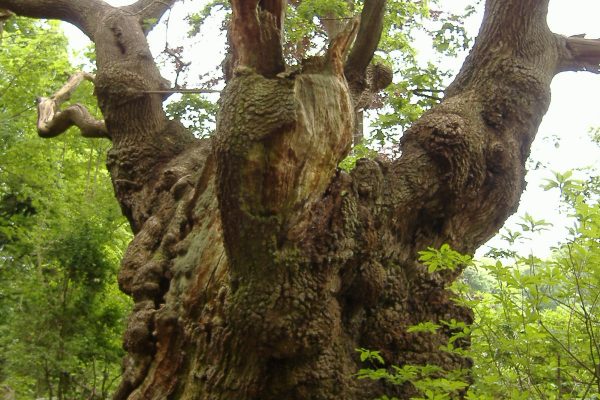
A veteran oak tree at Creech wood.~Forestry Commission -
Mixed agricultural landscape dominated by pasture with small pockets of horticulture and arable.
-
An intimate and enclosed field pattern with many small and irregular fields generally bounded by mixed-species hedgerows or woodland.
-
In parts, a very urban NCA dominated by the city and port of Southampton and other large towns such as Waterlooville and Havant. The more rural hinterland is characterised by small, loosely clustered or dispersed settlements, intermixed with isolated farmsteads.
-
Fragmented by major transport links, including the M3 to London and the M27 to Portsmouth which cross the NCA.
Relationship with the coast
The adjacent coastline is covered by the following Shoreline Management Plans:
- Selsey Bill to Hurst Spit
The adjacent coastline includes the following Marine Plan – Marine Character Areas (MCAs):
- The Solent
Selsey Bill to Hurst Spit Shoreline Management Plan
Shoreline Management Plans are developed by Coastal Groups with members mainly from local authorities and the Environment Agency. They identify the most sustainable approach to managing the flood and coastal erosion risks to the coastline in the short, medium and long term. This could inform actions within the NCA.

Description for the The Solent Marine Character Area
Seascape Character Assessments have been produced for all marine plan areas in England, extending along the coast to the High Water Mark. Information in the Seascape Character Assessments could inform actions along the coastline of the NCA.